International Journal of Emerging Technology and Advanced Engineering
Website: www.ijetae.com (ISSN 2250-2459, Volume 2, Issue 10, October 2012)295
Comparative Analysis of Spatial Rainfall-Runoff Estimation
Using Advance Geospatial Tools, ANN & Empirical approach
RK Suryawanshi
1, SS Gedam
1, RN Sankhua
21
Center of Studies for Resource Engineering, IIT Bombay, India
2National Water Academy, Pune, India
Abstract - Hydrologic parameters such as rainfall, runoff etc vary both in space and time. For most of the hydrological models, one of the main elements involved is rainfall-runoff process. Determination of the amount of average rainfall or runoff that a given storm event will produce on each sub-basin is of prime importance as it is major cause of error in the applied hydrology. To take care of the spatial variability, the watershed is divided into various sub-basins with hydro meteorologically homogeneous characteristics like rainfall pattern to arrive at representative spatial runoff. Larger the number of sub-basins, better is the accuracy. Using modern tools of geospatial technology(SRS,GIS) as well as Artificial Neural Networks (ANN), it is possible to achieve the objectives of representative as well as more accurate spatial rainfall and concurrent runoff. This paper discusses Digital Rainfall Modelling- an innovative tool for estimation of spatial rainfall for the storm event with the objective of more accurate assessment of the spatial rainfall distribution. For spatial runoff estimation, hydrologic models such as AGricultural Non Point Source [AGNPS] model, HEC-1, HEC GEOHMS, ILWIS, SWAT, as well as Arc-CN Runoff tools of ESRI at Arc GIS are reported. Estimation of spatially varied runoff depths using Arc-CN Runoff tools -Digital Runoff modeling, is discussed. Land use and soil map of the catchment are used as inputs. The digital runoff thus obtained for the event is compared with the same obtained using ANN and rational formula with respect to the observed runoff for the events occurred in Panshet reservoir catchment within Krishna river basin in India.
Keywords - ANN, Digital Rainfall, Digital Runoff, GIS, SRS,
I. INTRODUCTION
For most of the hydrological models, one of the main elements involved are rainfall-runoff process. A watershed is usually a complex heterogeneous system. Hydrologic processes vary both in space and time.
To take care of the spatial variability, the watershed is divided into various sub-basins with hydro meteorologically homogeneous characteristics like rainfall pattern to arrive at representative spatial runoff. Larger the number of sub-basins better is the accuracy. Determination of the amount of average rainfall or runoff that a given storm event will produce on each sub-basin is of prime importance as it is major cause of error in the applied hydrology.
Using modern tools of geospatial technology as well as artificial neural networks it is possible to achieve the objectives of representative as well as more accurate spatial rainfall and concurrent runoff.
II. THE STUDY AREA
The study area is the Panshet reservoir catchment within Krishna river basin in India. The study basin has rainfall network of four stations namely at Mangaon Koshimgarh, Shikholi, & Panshet. The location of these stations is digitized & the layer is depicted at Fig.1. The rainfall events details are as per Table1.
Fig.1Panshet rainfall network
Table1 Rainfall events
Sr. No. Beginning of event Ending of event Time step
Date Time Date Time Hrs
1 18 July-87 1200 20 July 87 2100 3
2 23 July-89 1800 29 July89 0900 3
International Journal of Emerging Technology and Advanced Engineering
Website: www.ijetae.com (ISSN 2250-2459, Volume 2, Issue 10, October 2012)296
III. DIGITAL RAINFALL ESTIMATIONRainfall hyetographs are required for each sub basin at desirable shorter intervals. The mean areal value (R) of rainfall over a basin area A, can be algebraically expressed as
--- (1)
Where r(x, y) is the rainfall surface function which is never known but can be approximated from the point rainfall values r1, r2, --- rN measured by gauges. The simplified results for average areal rainfall can be obtained using geospatial tools[7][8]. D.K.Christian et al (2000) [1] tried rainfall disaggregation using Poisson cluster model. James E. Ball and Kin Chai Luk also reported modelling spatial variability of rainfall over a catchment.
In this study the point rainfall of the four stations collected for the study area is distributed spatially using the innovative concept of Digital Rainfall Model (DRM). The four station point rainfall is distributed spatially using the innovative concept of Digital Rainfall Model (DRM). The concept is similar to Digital Elevation Model (DEM). The pixel wise spatial distribution of the rainfall is achieved for each of the three hourly spell of the rainfall using Inverse Distance Weights (IDW) available in spatial analysis in ARC-GIS tools. The sample pixel wise variation of rainfall in the study basin for the duration is depicted in Fig.2 Finally the combined digital average rainfall for the event in the basin is computed. Accordingly the hyetographs computed are shown in Fig.3
Fig.2 Digital Rainfall Model (DRM)
Fig.3 Event Hyetograph Using DRM
IV. DIGITAL RUNOFF ESTIMATION
For estimation of spatially distributed runoff forms the crucial exercise in hydrologic modeling.[2] The runoff curve number (CN) method developed by the Soil Conversation Services (SCS) with CN values for Indian conditions are used for the purpose. The objective is to estimate direct runoff depth from storm rainfall depth based on the parameter referred to as “Curve Number” which are estimated on the information obtained from various thematic maps of the catchment such as land use, land cover/ soils, as well as antecedent moisture condition using following equation.
Q = [CN (P-2) –200]2/CN [CN (P-8) + 800] --- (2) Subject to P > (200/CN)-2, else Q = 0
Where, P = Total Precipitation Q = Direct runoff
CN =Curve Number (0-100)
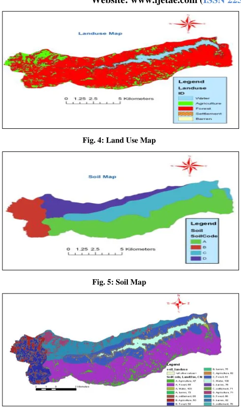
The SCS have classified various soils characteristics on the basis of infiltration rate and the runoff curve numbers for various combinations of soils and covers.[3][4] The curve numbers are assessed using the clip layer obtained using land use and hydrologic soil group layer respectively with appropriate antecedent moisture conditions using ARC-CN.The satellite image (IRS -LISS-III) of the study area has been used for getting classified into land use groups (Fig.4) using ERDAS IMAGINE. Soil map of the study area (Fig.5) is based on the All India Soil Survey Map.[5] [6]
0 20 40 60 80 100 120 140
International Journal of Emerging Technology and Advanced Engineering
Website: www.ijetae.com (ISSN 2250-2459, Volume 2, Issue 10, October 2012) [image:3.612.47.292.125.546.2]297
Fig. 4: Land Use Map [image:3.612.326.559.127.301.2]Fig. 5: Soil Map
Fig.6: Soil- Land Use Intersection Map
The clip intersection layer of land use and soil map is obtained using ARC-CN (Fig.6). [9]Using these layers and the lookup table for AMC –II conditions, the CN for each land use category & in turn digital runoff depths for each rainfall depths of the storm event are computed. The Digital Runoff with respect to each of the digital rainfall are plotted. The computed value of each of the three hourly average of the digital runoff is shown in Fig. 7
Fig.7 Digital Runoff Results
V. RUNOFF ESTIMATION USING ANN
For estimation of spatially distributed runoff has also been tried using Artificial Neural Networks (ANN). Using the most commonly used sigmoidal transfer function, the output of typical neuron can be written as follows :
y = 1/ ( 1+ w –ax ) ---- (3)
Where x is the input, y is the output, w is the weight and a is the coefficient or gain which adjusts the slope of the sigmoidal function that changes between the two asymptotic values (0 and +1). NeuroIntelligence (neural network software) is used in this study to gain the maximum productivity in preprocessing data, efficient network architecture, analyze performance. Network with four input layers, one hidden layer and one output has been adopted for the study (Fig.8). For estimation of three hourly runoff depths for the values of corresponding rainfall depths of four rain gauge stations in the study area have been used as input. Training, testing & validation have been carried out using the observed events. [10][11]
[image:3.612.342.545.548.643.2]International Journal of Emerging Technology and Advanced Engineering
Website: www.ijetae.com (ISSN 2250-2459, Volume 2, Issue 10, October 2012)298
The ANN model results obtained as computed runoff depths are compared the observed runoff depths. The same are depicted in Fig. 9,Fig.9: ANN Runoff Results
The model results as shown in Fig.9 indicate that the observed and computed runoff depths are more or less matching with respect to peaks as well as time. Hence it can be inferred that the ANN model can be very well used for runoff forecasting with more accuracy and very short processing time.
VI. RUNOFF ESTIMATION USING EMPIRICAL TECHNIQUE
Determination of peak runoff for a basin can be determined using the Rational Formula. The Rational Formula states:
Q= C*I*A --- (4)
Where Q= Peak runoff rate (m³/sec), C =Runoff coefficient, I = Rainfall intensity (mm/hr), A = Drainage area (km²)
The digital rainfall depths for 3 hrly durations as obtained earlier are used as input for the rational formula. The variable runoff coefficient has been used for various events. The time duration of 3hrs, which is approximately same as the time of concentration for the catchment, estimated using California Equation. Since the runoff depths need to be compared, the peak discharges per unit area are computed & the results obtained are indicated in Fig.10.
Fig.10: Empirical Runoff Results
VII. RESULTS & CONCLUSION
The digital runoff results, ANN runoff depths & empirical runoff depths are compared with the observed runoff depths. The relative error graph for all three methods have been plotted and depicted in Fig.11
Fig.11 Relative Error Analysis
While comparing the relative errors with respect to the observed runoff depths, it is seen that the results are more or less similar for digital runoff & ANN runoff. It is seen that the during many of the event time the digital runoff depths are less estimated compared to observed values whereas it is other way in case of results obtained for ANN runoff. Relative errors are on negative side in case of empirical & ANN runoff & on positive side in case of digital runoff. It can be concluded that the results obtained using digital rainfall model can be very well used for runoff estimation with more accuracy and very short processing time.
REFERENCES
International Journal of Emerging Technology and Advanced Engineering
Website: www.ijetae.com (ISSN 2250-2459, Volume 2, Issue 10, October 2012)299
[2 ] A.H. Schumann , RFunke G.A. Schultz (1999) “Application of GISfor conceptual rainfall runoff modelling “ Journal of Hydrology 240 (2000) 45-61 Ministry of Agriculture, Govt. of India “Estimation of Direct runoff from rainfall ’’ Handbook of Hydrology, Ch.5 [3 ] Xiaoyong Zhan et al(2004) “An application example for a watershed
in Lyon County and Osage County” Kansas, USA, is presented. 23 # 2004 Elsevier Ltd.
[4 ] Xiaoyong Zhan ArcCN-Runoff: (2004) “An ArcGIS tool for generating curve number and runoff maps” February 2004 Environmental Modeling & Software (2004)
[5 ] G. Aronica & M. Cannarozzo (1999) “Studying the hydrological response of urban catchmets using a semi distributed linear, non linear model’’ Journal of Hydrology 238 (2000) 35-43.
[6 ] Brand I., P. Fernandez, F. Bokraoui (1999), “Study of rainfall – runoff process in the Andes region using a continuous distributed model” Journal of Hydrology 216 (1999) 155-171
[7 ] James E. Ball and Kin Chai Luk (1998) “Modeling Spatial Variability of rainfall over a catchment” – Journal of Hydrologic Engineering ASCE, April 1998, 122-130
[8 ] Kohler M.A. and R.K. Linsley (1951), “Predicting runoff from Storm Rainfall” Res Paper No.34, Weather Bureau, US. Dept. of Comm. W.
[9 ] Vijay P. Singh(1989), “Hydrologic Systems – Watershed Modelling” Vol.I and II (1989) Prentice Hall Inc.
[10 ]A.Sezin Tokar, Peggy A. Johnson (1999), “Rainfall – Runoff Modelling using Artificial Neural Network”, - ASCE Journal of Hydrologic Engineering Vol4 No.3 (July 1999) Paper No. 14723 (232-239)
[11 ]Cameron M. Zealand, Donald H. Burn Slobodan, P. Simonovie (1999), “Short Term Streamflow forecasting using artificial neural networks” Journal of Hydrology 214 (1999) 32-48
Websites:
http:/www.eusoils,jrc.it/esdb_archive/EuDASM/Asia/lists/cin.htm
http:/www.water.usgs.gov/wid/FS
http:/www.agu.org/eos
http:/www.susquehannafloodforecasting.org
http:/www.nidm.gov.in/idmc/Proceedings