Appendix A
Methodology
Methodology for Strategic Housing Land Availability
Assessment
Weymouth and Dorchester Housing Market Area
December 2009 Update
1.0 Introduction
1.1 Planning Policy Statement 3: Housing (PPS3) sets out an approach for planning for housing, in response to recommendations in the Barker Review of Housing Supply published in March 2004. In particular it sets out a framework to improve affordability and supply of houses in all communities by ensuring that land availability is not a constraint on the delivery of homes. These changes include the requirement for Local Planning Authorities (LPAs) to identify and maintain firstly a rolling five-year supply of deliverable land for housing, and, secondly, to identify sufficient developable land for at least a 15 year period in their forthcoming planning documents.
1.2 In order to reinforce the „plan, monitor, manage‟ approach to planning while being more responsive to land supply issues, PPS3 sets out that LPAs should be informed by a robust evidence base to aid in the formulation of local planning policies and the determination of planning applications. In particular, PPS3 states that LPAs should undertake a Strategic Housing Market Area (HMA) Assessment1 to assess local housing need and demand, and a Strategic Housing Land Availability Assessment (SHLAA)2 to identify and monitor current and future land availability for housing based on agreed HMA boundaries.
2.0 What is a HMA?
2.1 Strategic HMA Assessments will form a major part of the evidence base for the production of future planning documents which concern housing issues, allowing LPAs to understand the dynamic and complex housing markets which operate in their area. The main outcome of undertaking this work at the sub-regional level is to provide a valuable insight into how housing markets operate both now and in the future, including an assessment of local housing need, demand and market conditions.
2.2 In Dorset partnership working is being undertaken to inform housing policy formulation at the sub-regional and local levels. The HMA work has identified that there are two broad housing markets operating in Dorset, the Bournemouth & Poole HMA and the Weymouth and Dorchester HMA.
2.3 The Practice Guidance for undertaking SHLAA2 (the „Practice Guidance‟) recommends that the study area should be set at the HMA level. Therefore, two SHLAAs will be undertaken within the county and agreement to work in partnership has already been made between the Councils in Dorset.
2.4 This methodology document relates to the SHLAA that will be undertaken by the Partnership of Councils in the Weymouth and Dorchester HMA (the Partnership). This will cover the administrative areas covered by Weymouth and Portland Borough Council and West Dorset District Council.
3.0 What is a SHLAA?
3.1 The primary role of a SHLAA is to:
Identify sites with potential for housing Assess their housing potential
Assess when they are likely to be developed
3.2 One of the key requirements of the SHLAA will therefore be to identify and assess the deliverability and developability of sites that have the potential for new housing development. The SHLAA will need to identify sufficient specific sites to meet the strategic housing requirement within a LPA area for at least the first 10 years of a plan, but preferably for at least 15 years.
3.3 The SHLAA will be a technical document only but, once completed and approved by each LPA within the Partnership, will form a key component of each Authority‟s evidence base, being used to inform judgements on the future pattern of development and the allocation of land for housing. Judgements concerning whether sites should be allocated in future planning documents will be made through the statutory plan process, which will further test the suitability of any sites identified in a SHLAA which may be proposed for housing development.
3.4 To remain a useful tool in planning for the delivery of housing, the SHLAA will need to be comprehensive in its identification and assessment of sites and updated on an annual basis. It will be reported through the Annual Monitoring Reports, which are produced each year by each respective LPA.
3.5 The SHLAA will be undertaken by West Dorset District Council and Weymouth and Portland Borough Council on a joint basis and there will be one final report issued on behalf of both authorities. Each authority will also produce a separate report detailing the information for that particular local authority area.
4.0 Core Requirements and Outputs of a SHLAA
4.1 In order that a SHLAA can be used as a robust and credible evidence base, the Practice Guidance sets out some minimum requirements. The SHLAA should:
Set out a list of sites, cross referenced to maps showing locations and boundaries of specific sites (and showing broad locations, where necessary)
Assess the deliverability/developability of each identified site (i.e. in terms of its suitability, availability and achievability) to determine when an identified site is realistically expected to be developed Identify potential quantity of housing that could be delivered on each
identified site or within each identified broad location (where necessary) or on windfall sites (where justified)
Set out constraints on the delivery of identified sites
Make recommendations on how these constraints could be overcome and when
4.2 Together with the general methodology, set out in the Practice Guidance, these core requirements have been used to develop the proposed methodology, as set out below.
5.0 The Methodology
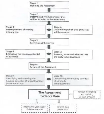
5.1 The Government‟s Practice Guidance sets out eight stages for the preparation of a SHLAA, with two further stages that may be undertaken if it is not possible for a LPA to identify an adequate supply of specific deliverable or developable sites for housing. The stages of the SHLAA are set out in Figure 1.
Stage 1: Planning the Assessment
5.2 There is agreement between the two Planning Authorities within the Weymouth and Dorchester HMA that the Assessment should be undertaken jointly in order to provide a robust and credible source of evidence for the production of future local planning policies.
5.3 In addition to the partnership of Planning Authorities, key stakeholders (listed in Appendix A) have been invited to join a SHLAA Panel.
5.4 In terms of resources it is proposed that Planning Officers will undertake the majority of the work. The Partnership of LPAs has current experience of undertaking similar joint assessments, in terms of the outgoing „Urban Capacity Studies‟, as well as continuing experience from evidence gathering for the production of a range of future planning documents. Therefore, the Partnership should be able to meet the requirements of the SHLAA.
5.5 It has been agreed that each Council will provide adequate resources to undertake the study. In addition to Planning Officers working on the preparation of planning policies, officers from Development Control, GIS, Tree and Landscape, Design, Land Management, etc. teams will also be involved in the production of the SHLAA.
5.6 It is anticipated that all members of the SHLAA Panel will contribute towards the initial identification of sites, as well as advising the Partnership on their „availability‟ and „achievability‟, as set out in Stage 7 of the methodology.
5.7 Each Planning Authority will be responsible for undertaking the Assessment for their administrative area, following the confirmed methodology. In terms of quality assurance, the assessment of sites will be presented to the SHLAA Panel in order to agree the findings, or to recommend changes. As a technical document produced as evidence for the production of future planning documents, the SHLAA will be scrutinised by each Authority through its own Committee procedures or relevant steering groups.
5.8 A broad timetable of key milestones for the SHLAA is proposed in Appendix B.
Stage 2: Determining which sources of sites will be included
in the Assessment
5.9 The Practice Guidance identifies examples of the sources of sites that have the potential for housing and which should be covered in the Assessment:
Table 1: Sources of sites
Sites in the Planning Process
Land allocated (or with permission) for employment or other land uses which are no longer required for those uses
Existing housing allocations and site development briefs Unimplemented/outstanding planning permissions for housing Planning permissions for housing that are under construction Sites not currently in the planning process
Examples:
Vacant and derelict land and buildings Surplus public sector land
Land in non-residential use which may be suitable for re-development for housing, such as commercial buildings or car parks, including as part of mixed-use development
Additional housing opportunities in established residential areas, such as under-used garage blocks
Large scale redevelopment and re-design of existing residential areas
Sites in rural settlements and rural exception sites Urban extensions
New free standing settlements
5.10 The Partnership proposes to categorise these sources in a similar way to that set out in existing Urban Capacity Studies in the county. However, some refinement of the UCS categories has taken place to accommodate the differences between the UCS and SHLAA processes. The new categories are set out in Appendix C.
5.11 The Practice Guidance states that “particular types of land or areas may be excluded from the Assessment. Where this is the case, the reasons for doing so will need to be justified and agreed by the members of the partnership.”3
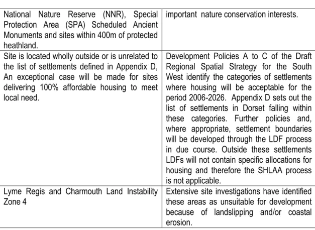
It is proposed that if sites are identified which fall within the designations listed below, they will be assigned a nil housing potential, due to their inappropriateness as potential housing sites:
Table 2: Land to be excluded from SHLAA
Sites to be excluded from SHLAA Justification
Site of Special Scientific Interest (SSSI), Special Area of Conservation (SAC), Ramsar site (wetlands of international importance),
National Policy advices against development that would have an adverse impact on national and internationally
National Nature Reserve (NNR), Special Protection Area (SPA) Scheduled Ancient Monuments and sites within 400m of protected heathland.
important nature conservation interests.
Site is located wholly outside or is unrelated to the list of settlements defined in Appendix D, An exceptional case will be made for sites delivering 100% affordable housing to meet local need.
Development Policies A to C of the Draft Regional Spatial Strategy for the South West identify the categories of settlements where housing will be acceptable for the period 2006-2026. Appendix D sets out the list of settlements in Dorset falling within these categories. Further policies and, where appropriate, settlement boundaries will be developed through the LDF process in due course. Outside these settlements LDFs will not contain specific allocations for housing and therefore the SHLAA process is not applicable.
Lyme Regis and Charmouth Land Instability
Zone 4 Extensive site investigations have identified these areas as unsuitable for development because of landslipping and/or coastal erosion.
Stage 3: Desktop Review of Existing Information
5.12 An initial desk top review will be undertaken in order to identify sites with potential for housing. The Government‟s Practice Guidance sets out some of the data sources that can be used to identify sites with potential for housing (Table 3). Information identified at this stage of the Assessment will be used to plan for the site survey stage.
Table 3: Sources of Information
Sites in the planning process Purpose
Site allocations not yet the subject of planning permission
To identify sites Planning permissions/sites under
construction (particularly those being developed in phases)
To identify sites
Site specific development briefs To identify sites and any constraints to delivery
Planning application refusals To identify sites – particularly those applications rejected on grounds of prematurity, overdevelopment or poor design
Dwelling starts and completion records
To identify the current development progress on sites with planning permission
Other sources of information that may help to identify sites
Capacity Study any constraints to delivery Local planning authority Empty
Property Register
To identify vacant buildings English House Condition Survey To identify buildings
National Land Use Database To identify buildings and land, and any constraints to delivery
Surplus Public Sector Land To identify buildings and land Local planning authority Employment
Land Review
To identify surplus employment buildings and land
Valuation Office database To identify vacant buildings Local planning authority vacant
property registers (industrial and commercial)
To identify vacant buildings
Commercial property databases eg estate agents and property agents
To identify vacant buildings and land Ordnance Survey maps To identify land
Aerial photography To identify land
5.13 During this stage a pro forma will be sent out to all stakeholders within the Weymouth and Dorchester HMA, and an advert will be placed in the local newspapers, requesting the formal proposal of potential sites. A copy of this „new sites‟ pro forma is attached as Appendix E.
5.14 The owners or agents of sites which already have the benefit of an outstanding planning permission will be separately contacted to assess when or whether their site is likely to come forward for housing. A copy of this pro forma is attached as Appendix F. Both of these forms are available to download on the relevant planning page of each LPA‟s website, additionally, forms will be sent out to those requesting them.
Stage 4: Determining which sites and areas will be surveyed
5.15 The Practice Guidance states that all sites identified by the desk-top review and from stakeholders should be visited. This will aid in the robustness of the Assessment, particularly where currently held information on the site held may be inconsistent or incomplete. Site surveys will also identify any possible constraints. Those sites which have been granted planning permission will not need to be surveyed, as the potential and constraints on these sites will have already been identified.
5.16 Although the need to survey each new site is likely to have huge resource implications, it will be a necessary part of the Assessment and will aid in providing adequate evidence that there is a reasonable chance of a site being developed for housing.
5.17 The Practice Guidance indicates that the following factors should be taken into consideration when determining how „comprehensive‟ (in
terms of geographic coverage) and „intensive‟ (in terms of the minimum size of site surveyed) the survey element of a SHLAA should be:
The nature of the housing challenge – assessments will need to
be more comprehensive and intensive where existing or emerging housing provision targets in the study area are high and/or where housing market conditions signal worsening affordability, reflecting the need to identify more sites for housing;
The nature of the area – in areas dominated by smaller rural
settlements, it may be necessary to identify all the sites with potential for housing, whereas this may not be necessary or feasible in more urbanised areas;
The nature of land supply – where a large proportion of housing is
expected to be delivered on small sites this may mean that the survey needs to identify smaller sites than would be necessary in an area where larger sites are likely to make up the bulk of supply; and,
The resources available to the partnership – which can be
brought together for best effect and should reflect the scale of the task. The methodology provides different approaches for some stages to reflect any differences in resources.
Stage 5: Carrying out the survey
5.19 Following the desktop survey, all sites identified will be visited by officers of the relevant LPA in order to make an informed judgement as to the likelihood of residential development on each site.
Stage 6: Estimating the housing potential of each site
5.20 The Practice Guidance recommends that the estimate of housing potential on each site surveyed should be guided by the existing or emerging development plan, particularly in terms of local policies towards housing densities.
5.21 It is proposed that density assumptions will be consistent throughout the Weymouth and Dorchester HMA, based on national guidance and regional and local planning policies.
5.22 To produce an estimate of the number of dwellings that could be provided on each identified site, a three stage process is proposed (See Appendix G). Additionally, the Practice Guidance recommends the use of design exercises to assist estimation of site potential. Resources permitting, comparison will be made with sample schemes from elsewhere in the study area which are deemed to represent a form of development appropriate to the site under consideration. In some cases it may be appropriate to sketch a scheme from scratch in order to visualise the site's potential.
Stage 7: Assessing when and whether sites are likely to be
developed
5.23 PPS3 requires LPAs to identify sufficient and specific „deliverable‟ sites to deliver housing within a five year period and longer-term „developable‟ sites. It also requires LPAs to identify those sites which are regarded as „not currently developable‟, stating the current constraints affecting their developability.
5.24 To be considered „deliverable‟, sites are required to be:
Suitable – the site offers a suitable location for development now and would contribute to the creation of sustainable communities Available – the site is available now
Achievable – there is a reasonable prospect that housing will be delivered on the site within five years
5.26 The final part of Stage 7 requires an assessment to be made for those sites which are found to be „not currently developable‟, as to what action would be needed to overcome those constraints. A separate statement will be produced on how constraints could be overcome on a site-by-site basis.
Stage 8: Review of the Assessment
5.27 The initial survey of sites and the assessment of their deliverability/developability will enable the housing potential in each Planning Authority to be made, this will allow a housing trajectory for each LPA to be produced. Once all of the surveys and assessments in the Partnership are complete, the total housing potential for the Weymouth and Dorchester HMA will be collected to produce an indicative housing trajectory, setting out how much housing can be provided, and at what point in the future.
5.28 The Practice Guidance recommends that a risk assessment should be made at the review stage in order to assess the risk of sites not coming forward as anticipated. If insufficient sites are identified in order to meet the strategic housing targets for a Planning Authority, it will be necessary to investigate how this shortfall should best be planned for. 5.29 Where there is an identified shortfall in deliverable/developable sites for
housing within a LPA area, it is proposed that one or both of the options set out in Stages 9 and 10 will need to be undertaken.
Stage 9: Identifying and assessing the housing potential of
broad locations (where necessary)
5.30 This is an optional stage that may be undertaken by one or more of the LPAs in the partnership, where an adequate supply of sites with housing potential cannot be identified.
5.31 Broad locations, where further housing development is considered feasible and will be encouraged, but where specific sites cannot yet be identified, may be identified in a SHLAA, in order to provide a level of certainty to communities and developers concerning future patterns of development. Examples of broad locations include land:
Within and adjoining settlements – where housing development could be encouraged or small extensions to existing settlements Outside settlements
5.32 It is proposed that if a Planning Authority is required to identify broad locations, consultation with the SHLAA Panel will be made in order to establish the criteria to assess these locations both within and outside existing built up areas and subsequently the housing potential within those locations.
Stage 10: Determining the housing potential of windfall (where
justified)
5.33 While PPS3 sets a clear expectation that the supply of land for housing should be based on specific sites and, where necessary, broad locations, it also recognises that in some circumstances a windfall allowance may be justified.
5.34 Where it is decided that a LPA is required to undertake an assessment of windfall, in order to meet its strategic housing requirements, this will need to be based on recent historic completion rates for each source of housing potential – as identified in Stage 2. This assessment will need to consider whether the annual rate of supply is likely to increase or decrease, whether the pattern of redevelopment is likely to remain the same or change, and whether current market conditions are likely to stay the same, worsen, or improve in the future.
5.35 It is proposed that where a LPA cannot identify enough specific potential housing sites to meet their strategic housing requirement they will determine housing potential from recent historic windfall levels, excluding any sites already counted in their Assessment. It is proposed that where this requirement is necessary the method for determining a historic windfall rate will be discussed with the SHLAA Panel.
Appendix A List of key stakeholders invited to join the SHLAA Panel
Betterment Properties Ltd FH Cummings
Lomand Homes
Magna Housing Association Synergy Housing Association Pro Vision Planning
Hull Gregson & Hull Environment Agency Natural England
West Dorset District Council Councillor
Appendix B Timetable and Key Milestones
Task Date
Site request public consultation
Submission of Annual Monitoring Report (including 5 year land supply calculation
Final Report
January – February 2010
31st December 2010
Appendix C
Site Classifications and definitions
SHLAA Category Definition
Estimate of theoretical capacity Subdivision of existing housing, Redevelopment of existing housing or Intensification (SRI)
Large dwellings or large plots where the existing dwelling could either be subdivided or redeveloped or additional dwellings could be built on the plot
Based on site area and density assumptions in
appendix G
Flats over shops (FOS) Reuse of the upper floors of buildings where the lower floors are used for retail purposes
Count
Empty homes (EHS) Based on the Empty Homes Strategy Constrained yield taken from Empty Homes Strategy.
Previously developed vacant / derelict land and buildings (non housing) (PDL)
Previously-developed land, often called brownfield land, is land that was developed but is now vacant or derelict. This category includes NLUD categories (a) previously developed land now vacant, and (c) derelict land and buildings.
Based on site area and density assumptions in
appendix G
Redevelopment or Conversion of other uses (RXO)
Category includes all non-residential uses not assessed as part of Flats Over Shops.
Public open space is also not included in this category.
Based on site area and density assumptions in
appendix G
Redevelopment of car parks (RCP)
Public and private car parks Based on site area and density assumptions in
appendix G
Review of existing housing allocations in plans (RHA)
Sites allocated for housing within the adopted Local Plan not benefiting from a planning permission
Based on site area and density assumptions in
appendix G
Review of other allocations in plans (ROA)
All allocations within suitable areas that are not benefiting from planning permission.
Based on site area and density assumptions in
appendix G
Vacant land not previously developed (GRE)
Land which has not previously been developed or which has returned to Greenfield status over time, includes agricultural and forestry buildings.
Based on site area and density assumptions in
appendix G
Existing Planning Permissions (EPP)
Remaining uncompleted units on sites with planning permission
Remaining
uncompleted units on sites with planning permission. Rural Exception Sites
(REX)(West Dorset
Sites in rural areas that would not be considered except to supply 100% affordable housing to meet need
Based on site area and density assumptions in
Appendix D Settlements where sites will be surveyed West Dorset District Council
Sites within or related to the following towns and villages
Dorchester, Bridport, Sherborne, Chickerell, Lyme Regis, Beaminster, Bishops Caundle, Bradford Abbas, Broadmayne and West Knighton,
Broadwindsor, Buckland Newton, Burton Bradstock, Cerne Abbas, Charlton Down, Charminster, Charmouth, Crossways, Evershot, Littlemoor, Maiden Newton & Higher Frome Vauchurch, Mosterton, Piddletrenthide, Portesham, Puddletown, Salway Ash, Thornford, Trent, Winterbourne Abbas &
Winterbourne Steepleton, Yetminster
Sites for 100% affordable housing will be also considered within or adjoining the villages of: Abbotsbury, Bradford Peverell, Cattistock, Cheselbourne, Chetnole, Chideock, Corscombe, Dewlish, Drimpton, Frampton, Halstock, Langton Herring, Leigh, Litton Cheney, Loders, Longburton, Melcombe Bingham, Netherbury, Nether Compton, Osmington, Owermoigne, Piddlehinton, Puncknowle, Shipton Gorge, Stratton, Sydling St Nicholas, Symondsbury, Thorncombe, Toller Porcorum, Tolpuddle, Uploders, West Stafford, White Lackington and Winterborne St Martin. Other sustainable locations adjacent to settlements will be considered.
Weymouth and Portland Borough Council Sites within or adjacent to the following:
The built up area of Weymouth and the settlements of Upwey, Broadwey, Sutton Poyntz, Southwell, Easton, Weston, Fortuneswell and Grove
Appendix E: „new sites‟ Pro Forma
SHLAA 2 – Potential New Housing Site
Weymouth and Portland Borough Council and West Dorset District Council
Strategic Housing Land Availability Assessment Guidance Notes
Local planning authorities are required to undertake a Strategic Housing Land Availability Assessment to provide the evidence base to support the delivery of sufficient land to meet the community’s need for more homes. This exercise is being undertaken jointly by Weymouth and Portland Borough Council and West Dorset District Council
Weymouth and Portland Borough Council and West Dorset District Council have carried out the SHLAA exercise for 2008/09 and these can be viewed at
http://www.weymouth.gov.uk/home.asp?sv=661and
http://www.dorsetforyou.com/index.jsp?articleid=376162 respectively. We are now looking to produce the report for 2009/10.
If you wish to suggest a potential site and feel that it may make a
contribution to the overall housing land supply, please use the following form and return it to:
For sites in West Dorset: For sites in Weymouth and Portland:
Strategic Policy Forward Planning
West Dorset District Council Weymouth and Portland BC Stratton House Council Offices
58/60 High West Street North Quay Dorchester Weymouth DT1 1UZ DT4 8TA
Or electronically to : West Dorset: [email protected] Weymouth and Portland: [email protected]
Sites that were submitted for this exercise last year should not be re-submitted unless there have been significant changes to the status of the site.
Please ensure your form is returned by 22nd February 2010.
Before completing your form, please read the following guidance notes: Use a separate form for each site (additional forms may be downloaded by accessing the following webpage http://www.weymouth.gov.uk and entering SHLAA in the search function box or you may prefer to photocopy this form) Only information supplied on a form can be considered
Without this mapped information we are unable to register the site. You may obtain a base-map from:
West Dorset:
http://salisbury.westdorset-dc.gov.uk/LocalPlan/LPR1/InteractiveMap.htm
or phone: 01305 252433 or email: [email protected]
Weymouth: Go to website:
http://www.addresscafe.com/weymouth.aspx
or phone: 01305 838263 or email: [email protected] There is no threshold for sites.
Submit only sites:
Within or related to the existing settlements of: Dorchester, Bridport, Sherborne, Chickerell, Lyme Regis, Beaminster, Bishops Caundle, Bradford Abbas, Broadmayne and West Knighton, Broadwindsor, Buckland Newton, Burton Bradstock, Cerne Abbas, Charlton Down, Charminster, Charmouth, Crossways, Evershot, Littlemoor, Maiden Newton & Higher Frome Vauchurch, Mosterton, Piddletrenthide, Portesham, Puddletown, Salway Ash, Thornford, Trent, Winterbourne Abbas & Winterbourne Steepleton, Yetminster
Within or related to the built up area of Weymouth and the settlements of Upwey, Broadwey, Sutton Poyntz, Southwell, Easton, Weston, Fortuneswell and Grove
Sites for 100% affordable housing will also be considered within or adjoining the villages of: Abbotsbury, Bradford Peverell, Cattistock, Cheselbourne, Chetnole, Chideock, Corscombe, Dewlish, Drimpton, Frampton, Halstock, Langton Herring, Leigh, Litton Cheney, Loders, Longburton, Melcombe Bingham, Netherbury, Nether Compton, Osmington, Owermoigne, Piddlehinton, Puncknowle, Shipton Gorge, Stratton, Sydling St Nicholas, Symondsbury, Thorncombe, Toller Porcorum, Tolpuddle, Uploders, West Stafford, White Lackington and Winterborne St Martin. Other sustainable locations adjacent to settlements will be considered for 100% affordable housing.
Do not submit sites that already have planning permission for residential use, unless different proposals are identified. Do not submit sites which are allocated for housing in a local plan.
Ensure that your site is located within West Dorset or Weymouth and Portland.
If you are unsure about the suitability of a site that you have in mind, you may prefer to have a brief informal word with a planning officer before submitting a form. Please call 01305 252433 for sites in West Dorset and 01305 838214 for sites in Weymouth and Portland.
Please note that although all proposals will be considered, suggesting a site at this first stage does not guarantee that the land will be included for housing development in the final analysis.
Strategic Housing Land Availability Assessment
Potential New Housing Site
January 2010
Please complete the form clearly and legibly and to the best of your knowledge. You must give your name and address for your comments to be considered. You must attach a map showing the precise boundaries of the site
This form should be received by 22nd February 2010.
DATA PROTECTION AND FREEDOM OF INFORMATION
The information collected in this response form will be used by your local planning authority to inform the Strategic Housing Land Availability Assessment and subsequent components of the Local
Development Framework.
By responding you are accepting that your response and the information within it will be in the public domain, and that it may be disclosed if requested under the Freedom of Information Act. However, any published information will not contain personal details of individuals.
Your details
Name
Company / agent
Representing
Is your business housing development ? Yes No Your address Telephone Number email
For official use only:
Reference _________________ Received _________________ Acknowledged _________________
Site details
Site address
Site postcode
OS grid reference
Please attach a map outlining the precise boundaries of the site in its entirety and the part which may be suitable for housing (if this is less than the whole). Without this mapped information we are unable to register the site. If you are able to provide this information in GIS format we would be grateful.
Ownership of Site Are you the landowner of the site ?
Yes No
If ‘yes’, are you ? Sole owner
Part owner
Please list other owners:
If you’re not the owner, who is ? (please list if more than one)
CURRENT AND POTENTIAL USE
What is the site currently used for ?
In your view, what type and number of dwellings would you envisage for the site ?
Number of houses (or bungalows)
Number of flats
Would the site be solely for affordable housing ? If „yes‟ please tick: POSSIBLE CONSTRAINTS
To the best of your knowledge are there any constraints that may prevent development on the site? Please provide brief details where known.
Access difficulties Infrastructural requirements Topography or ground conditions Hazardous risks Contamination / pollution Flood risk Legal issues Other considerations
Do you believe constraints on the site could be overcome? If so, please explain.
AVAILABILITY
Over what broad timeframe would you anticipate the site could first become available for development:
Within the next 5 years i.e. by the end of March 2015
Within a period 5-10 years hence i.e. between 2015 and 2020 Within a period 10-15 years hence i.e. between 2020 -2025 After 15 years hence i.e. after 2025
If you anticipate the site could become available for development within the next five years, what would be your best estimate of a more precise year for commencement:
Before the end of March 2010
Between April 2010 and March 2011 Between April 2011 and March 2012 Between April 2012 and March 2013 Between April 2013 and March 2014 Between April 2014 and March 2015
Once commenced, how many years do you think it would take to develop the site ?
Number of years
If the site is likely to require phasing of development, could you please explain the likely timing of the phases and number of dwellings to be delivered at each phase
SURVEY ISSUES
In identifying such a site you are giving permission for an officer of the council to access the site in order to ascertain site suitability. In this context would there be any access issues to the site?
If yes, please provide contact details of the person who should be contacted to arrange a site visit.
Do you know of any other issues that we should be aware of (including any issues not covered above which might delay the site coming forward for development) ?
Please return this form together with a map which clearly identifies the boundary of the site by 22nd February to:
For sites in West Dorset: For sites in Weymouth and Portland
Strategic Policy Forward Planning
West Dorset District Council Weymouth and Portland BC Stratton House Council Offices
58/60 High West Street North Quay Dorchester Weymouth DT1 1UZ DT4 8TA
Appendix F – Existing sites pro-forma SHLAA 1 – Site with Existing Planning Permission
Weymouth and Portland Borough Council and West Dorset District Council
Strategic Housing Land Availability Assessment Guidance Notes
Local planning authorities are required to undertake a Strategic Housing Land Availability Assessment to provide the evidence base to support the delivery of sufficient land to meet the community’s need for more homes. This exercise is being undertaken jointly by Weymouth and Portland Borough Council and West Dorset District Council
The first stage is to identify as many sites as possible with potential for housing. Our records show that you hold a current planning permission(s) to develop land for housing. This land will therefore be included in the availability assessment but it would be most helpful if you could spend a moment to answer the following questions about the site and your intentions.
If you have permission to develop more than one site, please respond on a separate form for each site. Additional forms may be downloaded by accessing the following webpage http://www.weymouth.gov.uk and entering SHLAA in the
search function box, or from your local council office or you may prefer to simply photocopy this form.
Please return the form by 22nd February 2010 using Freepost envelope
supplied
Or electronically to : West Dorset: [email protected] Weymouth and Portland: [email protected]
Strategic Housing Land Availability Assessment
January 2010
Site with Existing Planning Permission
DATA PROTECTION AND FREEDOM OF INFORMATIONThe information collected in this response form will be used by your local planning authority to inform the Strategic Housing Land Availability Assessment and subsequent components of the Local
Development Framework.
By responding you are accepting that your response and the information within it will be in the public domain, and that it may be disclosed if requested under the Freedom of Information Act. However, any published information will not contain personal details of individuals.
Please confirm your details
Name
Company / agent
Representing
Is your business housing development ? Yes No Your address Telephone Number email
Please confirm site details
Site address
Planning permission number(s)
Ownership of Site
Are you the landowner of the Yes
For official use only:
Reference _________________ Received _________________ Acknowledged _________________
If ‘yes’, are you ? Sole owner Part owner
Please list other owners:
If you’re not the owner, who is ? (please list if more than one)
Over what broad timeframe would you anticipate the site could first become available for development:
Within the next 5 years i.e. by the end of March 2014
Within a period 5-10 years hence i.e. between 2014 and 2019 Within a period 10-15 years hence i.e. between 2019-2023 After 15 years hence i.e. after 2023
If you anticipate the site could become available for development within the next five years, what would be your best estimate of a more precise year for commencement:
Before the end of March 2009
Between April 2009 and March 2010 Between April 2010 and March 2011 Between April 2011 and March 2012 Between April 2012 and March 2013 Between April 2013 and March 2014
Once commenced, how many years do you think it will take to develop the site ?
If the site requires phasing of development, could you please explain/ confirm the likely timing of the phases and number of dwellings to be delivered at each phase
Do you feel the site has potential for an alternative housing proposal (alternative to the existing permission) in terms of the number or type of housing ? Please specify:
Do you know of any other issues that we should be aware of (including any issues not covered above which might delay the site coming forward for development) ?
Appendix G Estimating the Housing Potential of Each Site
Stage A – Calculating the theoretical site potential
Analysis of the density of new developments since 2001 has shown that in the majority of areas development has been above 30dph and in some areas over 100dph. These densities will be applied to give a theoretical capacity for each site. This will not take into account any reductions due to policy constraints, access, slope etc.
Density Zone Theoretical Density (dwellings per hectare) Definition
Town Centre At least 100 dph The centre of a town as defined in Local Plans plus a zone up to 400m from the edge of this town centre area. Suburban At least 50 dph The remainder of the built up urban
area
Village/Rural At least 30 dph All other areas outside of the main urban areas
Stage B – Onsite Estimate of Potential
The guidance states that as a minimum all sites identified in the desk-top review should be visited. At the time of the site survey, an estimate of the number of units that could be accommodated on a site should be made to aid in the final assessment of the site potential. This should be based on the character of the surrounding area, make allowances for access roads and other physical constraints observed on site and have regard to existing or emerging local planning policies.
For example, if a site is within an area of predominantly flatted development then it may be fair to assume that the site will also be developed for flats and therefore an assessment should make allowance for this. Conversely a site in a suburban area of a town with many detached/semi detached dwellings is less likely to be developed for flats.
If there are any existing dwellings on the site this should be documented to enable the net number of dwellings to be recorded.
Stage C – Final Assessment of Potential
This stage will pull together all the desktop and constraints information gathered on a site to make an assessment of the number of dwellings that could be provided on a site. Sample schemes that have been developed previously will be used to give an idea of the type of development that is viable and therefore inform the assessment of potential.
The final assessment should be undertaken using all of the constraint / site character information to arrive at a total. This constraint information should be used along side the initial theoretical assessment and the on site assessment produced in Stages 1 and 2 respectively. In addition, the sites identified by developers and land owners should contain their estimate of how many
dwellings they want to provide on the site which should be considered when arriving at the final estimate of the site potential.