© 2019, IRJET | Impact Factor value: 7.211 | ISO 9001:2008 Certified Journal | Page 7619
Technical paper on use of smart urban simulation software – ‘CitySIM’
for creation of smart cities in developing countries.
Shubham.S.Nayak
1, Vaishanavi Sharma
21,2Student,Dept. of Civil Engineering, Dr.D.Y. Patil Institute of Technology,Pimpri,Pune,India
---***---Abstract – As that smart cities are on nascent stage across
the developing countries. the role of urban simulation models and their visualization are used to help regional planning agencies evaluate alternative transportation investments, land use regulations, and environmental protection policies. Typical urban simulations provide spatially distributed data about number of inhabitants, land prices, traffic, and other variables for ex- “CitySIM” is to support more sustainable planning of urban settlements. This first version focuses on simulating buildings’ energy flows, but work is also under way to model energy embodied in materials and the flows of water and waste and inter-relationships between these flows; likewise their dependence on the urban climate. CitySIM software aims to provide a decision support at the urban scale.
Key Words: CitySIM,
1.INTRODUCTION
Nowadays, there is a huge increase in urban population and it is predicted to increase 70% by 2050. According to UN and IEA forecasts (UN, 2011) and (IEA, 2008), the urbanized population is expected to grow tremendously in the future. Thus, there will be enormous energy consumption and emission of greenhouse gases. It is necessary to identify solutions which will lead to significant reductions of resource and energy consumption while maintaining good quality of life standards for urban inhabitants. CitySim is a valuable decision support tool for urban planners and designers. This data involves weather conditions, solar panels, building properties, it’s components and occupancy. An efficient storage of the significant quantity of data is thus, needed and produced by the simulation of hundreds or thousands of shelters that can be realized by the use of databases (MySQL, PostgreSQL, Access or others).
1.1CitySIM
In common with its forerunner SUN tool (Robinson et al, 2007) the employment of CitySIM’s Java-based user interface to simulate and optimise building-related resource flows proceeds consistently with four key step –
-Meaning of site area and related atmosphere information.
- Choice and change of default datasets for the
types and age classes of structures to be contemplated.
- Definition of 3D type of structures; meaning of vitality supply and capacity frameworks to be demonstrated; refinement of structure and frameworks traits.
- Parsing of information in XML position from the GUI to the C++ solver for recreation of hourly asset streams; examination of results spilled back to the GUI.
The size of investigation may fluctuate from a neighborhood of only a couple of structures, however a area of a few hundred to a whole city of many thousand. Be that as it may, for each situation the center displaying ability and the information needs of these models is comparable. In the accompanying we depict this displaying ability and how this is being reached out to encourage altogether far reaching reproductions of urban asset streams and how these may be improved.
1.2 Methodology
This software is freely available on EPFL university website. This can be downloaded and used by logging in through email.
The first step of the simulation is to create a 3D of the location using 3D modelling programs as such SketchUp or AutoCADand then import the model in CitySim.
There are several parts in this software such as the canvas, district properties which enables to choose annual data of weather station, building properties, solar panels and the occupancy.
© 2019, IRJET | Impact Factor value: 7.211 | ISO 9001:2008 Certified Journal | Page 7620 Fig 1- CitySIM simulation of a city in progress
Finally, the results of simulation are displayed which can be altered by changing the values of parameters such as irradiation, temperature, solar production and heating and cooling demand.
1.2 CitySIM Tools
For the purposes of urban scale simulation, it is important to achieve a good compromise between modelling accuracy, computational overheads and data availability. In all cases these have been the criteria applied in the selection of an appropriate modelling methodology.
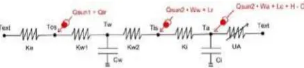
Thermal Model-
criteria it was decided to develop a model based on analogy with an electrical circuit; more specifically based on a resistor-capacitor network. In this case a conducting wall can be represented by one or more temperature nodes (Lefebvre, 1997).The heat flow between a wall and the outside air can be represented by an electric current through a resistor linking the two corresponding nodes and the wall’s inertia can be represented by a capacitance linked at that node. In our model (Kämpf and Robinson, 2007), which is a refinement of that due to Nielsen (2005), an external air temperature node Text is connected with
an outside surface temperature node Tos via an
external film conductance Ke, which varies according
to wind speed and direction (Figure 1). Tos, which
also experiences heat fluxes due to shortwave and long wave exchange, is connected to a wall node Tw
of capacitance Cw via a conductance defined by the
external part of the wall. In fact this node resembles a mirror plane, so that we have similar connections to an internal air node Ta of capacitance Ci via an
internal surface node Tis. Tis may also experience
shortwave flux due to transmitted solar radiation and a longwave flux due to radiant heat gains from internal sources (people and appliances) and Ta may
experience convective gains due to absorbed shortwave radiation, internal casual gains and heating / cooling systems. Finally, our internal air node may be connected with our external air temperature node via a variable resistance due to infiltration and ventilation.
Figure2: Monozone form of the CitySim thermal model.
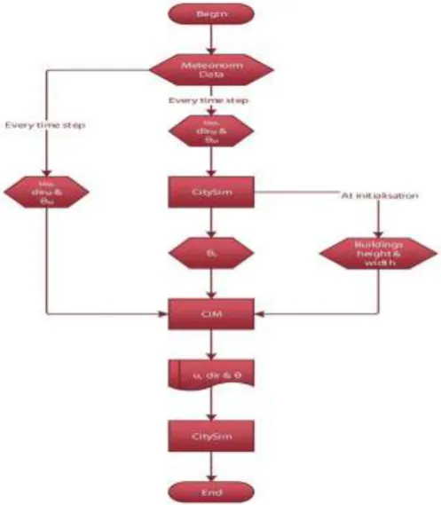
© 2019, IRJET | Impact Factor value: 7.211 | ISO 9001:2008 Certified Journal | Page 7621 Figure 3 – CitySIM workinging chart
3. CASE STUDIES
The following is the case study of a city in Switzerland. The Alt-Wiedikon residential neighborhood in Zurich (Switzerland) was selected as case study. In order to obtain a description of the 123 buildings in the zone of Alt-Wiedikon in a reasonable time, the following data sources were used: - Cadastral maps, usually available in digital format, provide reliable 2D representations of buildings' footprints and were thus used as a basis to define the building entities to be modeled. The altitude and average height of each building was extracted from digital surface and terrain models (DSM and DTM).
The buildings' register contains varying quality data about the geographical location, address, main allocation, construction date, renovation date, energy systems, etc. of buildings. In the absence of more detailed knowledge, the construction characteristics can be extrapolated from these parameters.
A company census, containing sensitive data related to the kind, location, activity and number of employees of all firms in the area will be used in the future to estimate the number of occupants in buildings.
A visual survey helped complete the physical model of the buildings in the area with estimates of the glazing ratio, window type and frame material of each building and allowed us to check the status and relevance for simulation of each building (demolished, garage, etc.).
It appears that sufficient data is available to create a first rough but extensive model of any urban zone in Switzerland. However, organising this data into a coherent simulation model is a highly time-consuming task if no appropriate tools are used, and research simulation tools are usually not adapted to perform this task
The CitySIM software has been used to examine the urban growth patterns in Quanzhou City based on remote sensing images over the period 1993-2008. It simulates two typical scenarios of urban development: the self-organizing expansion and planning oriented growth in Quanzhou. The observations seen in this were:
The CitySIM model could be a great tool to predict urban growth patterns beneath totally different situations.
Four landscape metrics, i.e., MPS, ED, AWMSI and MPI, for the planning-oriented growth state of affairs area unit considerably larger than those derived from self-organizing enlargement state of affairs. the look orienting state of affairs is additionally characterized by higher property and integrity of urban growth patches. This additional demonstrates that the urban designing, if with efficiency enforced, will facilitate to realize the goal of compact and property development.
[image:3.595.310.557.595.773.2]© 2019, IRJET | Impact Factor value: 7.211 | ISO 9001:2008 Certified Journal | Page 7622 It discover that urban enlargement rate and
special aggregation within the study space area unit weakening additionally the} hotspots of urban growth also changes as follows.
The "CitySIM practicableness study" was conducted with the funding of Ministry of Trade and business in Finland. The aim of the study was to research potentialities to develop a comprehensive modeling system, which may be utilized in order to judge the traffic volumes, emissions, atmospherical dispersion and noise among cities. The requirement for such operative tools is most imperative within the developing countries. The cities of the globe ought to improve considerably their understanding of the traffic systems and their impacts on the urban setting within the future.
3. CONCLUSIONS
The software CitySIM is aiming to provide a decision
support for urban energy planners and stakeholders to minimize the net use of non-renewable energy sources as well as the associated emissions of greenhouse gases. In developing and testing this software several ambitious aims were reached in order:
To support the software users to describe, in
an appropriate way, the 3D geometrical buildings forms at the scale of an urban district (comprising several hundreds of buildings) and to attribute these buildings thermo-physical
properties in an efficient way using a dedicated XML file format;
To simulate the energy demand of these
buildings, respecting the stochastic nature of occupants’ presence and behaviour and accounting for a range of commonly used heating, ventilation and air conditioning systems (HVAC systems);
To determine the energy supplies of these
buildings issued from renewable sources, including the radiation exchange driven by the urban environment, generated by a range of commonly used energy conversion systems;
To export standard text files (TSV) to allow the
software users to support the analysis of energy performance data in order to identify scope for improving upon buildings’ performance using their favourite graphical tool.
The software CitySim comprises CitySim Solver, a command-line Integrated Solver for simulating the energy demand and supply of buildings for space conditioning, together with the specification of the input buildings’ characteristics (in CitySim XML file format) and the climate files (Meteonorm CLI file format).
Field surveys within residential and non-residential buildings, as well as World-class building energy analysis software such as ESP-r, were used to proceed to the validation of the novel models and algorithms implemented in CitySim. The IEA BESTEST was passed with success.
REFERENCES
[1] Darren Robinson, Haldi F., Kämpf J., Leroux P.,
Perez D., Rasheed A., Wilke U, “Citysim: comprehensive micro-simulation of resource flows for sustainable urban planning,” Eleventh International IBPSA Conference, Glasgow, Scotland, June 27-30,2009.
[2] Daren Thomas, Clayton Miller, Jerome K¨ampf, and
Arno Schlueter,”Multiscale co-simulation of energyplus and citysim models derived from a building information model,” Fifth German-Austrian IBPSA Conference, BauSIM 2014.
[3] CITYSIM SIMULATION: THE CASE STUDY OF
© 2019, IRJET | Impact Factor value: 7.211 | ISO 9001:2008 Certified Journal | Page 7623
[4] https://www.epfl.ch/labs/leso/transfer/software/
citysim/
[5] CITYSIM - Validated assessment tool for simulating
urban traffic and environmental impacts.Jarkko Niittymaki (*), An Karppinen, Jaakko Kukkonen, Pekko
Ilvessalo C^), Erkki Bjork.
[6] Scenario simulation and changes of urban growth
patterns in central cities: A case study of Quanzhou, China,WU Wei1, ZHOU Shenglu1, WEI Yehua2, LIU Kehua3, CHEN Jianglong4, GUAN Weihua5.
[7] SCSimulator:AnOpenSource,ScalableSmartCitySimu