The state of gray forest soils, conditioned
by microclimatic variability, in the south
of the forest-steppe of the Central Russian
Upland
Natalya S. Kukharuk, Lidia G. Smirnova, Svetlana V. Kalugina,
Marina A. Polschina, Vladimir I. Chernyavsky
Department of Laboratory of Adaptive Plant Production and Agroecology, Belgorod Research Institute of Agriculture, Belgorod State University, Pobedy Str. 85, Belgorod, Russia
Abstract
Aim: The present study aimed to address the issues, relating to indicators of the soils state in conditions of climatic dynamics for the forest type phytocenoses of the south of the forest-steppe of the Central Russian Upland. Materials and Methods: The terrain of the studied area is a river valley of the Seversky Donets. A field study of soils and laboratory soil diagnostics were the basis of the research methodology. Soil survey data were analyzed for the period from 2011 to 2014. Chemical analysis of soil samples was carried out at the Federal State Funded Research Institution “Belgorod Agricultural Research Institute.” The geoinformational system ArcGis (in ArcMap software) with satellite mapping was used to prepare the map of the study area on the right bank of the river Seversky Donets 9. Results and Discussion: In the south of the forest-steppe of the Central Russian Upland, on the right bank of the river Seversky Donets, a certain regularity in the spatial arrangement of the subtypes of gray forest soils is observed: Gray forest soils are formed on the steep slopes (from 5° to 18°) of the north-eastern, north-north-eastern, and eastern exposures, in forest phytocenoses; and dark gray forest soils are formed on the upland and upper slope territories (from 0° to 5°). When calculating microclimatic parameters, it was established that the amount of multiyear temperatures over 10°C on slopes decreases with increasing their steepness. Humidity factor increases with the steepness of the slope in the northeast and north-north-east directions; the reverse pattern is noted for the eastern slope. Conclusion: Dark gray forest soils have a thickness of humus horizon from 42 to 52 cm. They have a higher level of fertility that is expressed in a low value of hydrolytic acidity, in a higher content of calcium and magnesium in the absorbing complex, compared to gray forest soils under the conditions of given forest phytocenosis. In both soil subtypes, a very low content of liable phosphorus, mobile potassium, and nitrate nitrogen was observed. Key words: Climatic dynamics, ecological conditions of the territory, gray forest soils, oak forest ecosystem, soil fertility indicators, soils diagnostics, southern forest-steppe of the Central Russian Upland
Address for correspondence:
Lidia G. Smirnova, Doctor of Biological Sciences, Head of the Laboratory of Adaptive Plant Production and Agroecology in the Belgorod Research Institute of Agriculture, Belgorod State University, Pobedy Street 85, Belgorod, Russia. E-mail: [email protected] Received: 09-09-2017
Revised: 16-09-2017 Accepted: 19-09-2017
INTRODUCTION
T
he forecast of climate change in the Russian Federation shows, that in fact, the observed trend in the warming in Russia will continue in the future.[1] Expected further climate changes can have both positive and negative effects.It is important to understand that climate transformation has significant regional features.[2] Therefore, the development of adaptation strategies requires an individual approach to each individual industry and each individual region, taking into account its natural and socioeconomic characteristics.
An assessment of current trends of observed climatic changes in the south of the Central Russian Upland, where the Belgorod region is located, shows that, in general, there is the aridization of climate. Hence, climatic changes are
ORIGINAL
AR
expressed in the following: The air temperature in winter has significantly increased; during the century, the winters became shorter by 10 days; the duration of spring period has increased, both due to the reduction of winter season, and due to some reduction of summer; agroclimatic conditions have improved; the duration of growing season increased for 7 days with an average daily air temperature of more than + 5°C, against the background of the increased total amount of precipitation in summer; the nature of humidification has changed; the probability of shower rains has increased; and the probability of prolonged extreme droughts has decreased.[3]
Soil as a component of the environment, of course, undergoes transformation under the influence of changing climatic parameters,[4] so its study is relevant and has practical significance. In the oak forest ecosystems of the forest-steppe, one of the main factors, determining their resource potential, is the fertility of soils, expressed through a system of diagnostic indicators.[5]
To achieve this goal, the following tasks were solved: To consider the main microclimatic characteristics of the gray forest soils formation in the subzone of a typical forest-steppe, on the right bank of the Seversky Donets River; to analyze the state of fertility of the investigated gray forest soils.
MATERIALS AND METHODS
The research area is located within the Oskol-Donetsk physical and geographical region of the subzone of a typical forest-steppe on the right bank of the river Seversky Donets (Shebekinsky district of the Belgorod region).
The terrain of the studied area is a river valley of the Seversky Donets. It has a well-defined asymmetry, the right slope is steeply elevated, and the left one is more gentle with two sandy upland fringes. The slopes of valleys and narrow watershed uplands are cut by short circus draws, which are characteristic forms of relief in the areas of distribution of Marly-Chalk rocks. There are small circus landslides in the upper reaches of the draws and hollows.[6]
The vegetation cover of the territory reflects the features of the northern forest-steppe, which is characterized by the alternation of forests with meadow steppe, represented by zonal and intrazonal types of vegetation and 7 phytocenotic types: Forest species (19.9%), shrubs and fringes species (3.15%), meadow species (21.6%), steppe species (17.6%), wetland and coastal communities (15.5%), chalky denudation (7.2%), and synanthropic species (14.9%). Chalky bores were saved rarely, and now, they are unique.[7]
On the watershed of the Seversky Donets River, there are upland oak forests. The main forest-forming species are
ash, oak, maple, and linden. Hazel, spindle, and thorn are in the underbrush. There is a well-developed undergrowth of various shrubby species and herbaceous layer in the forests. Their composition is determined by the quality of the forest, moisture conditions, the nature of the soil-forming and underlying rocks, and the meso- and micro-relief conditions.[8]
Field study of soils and laboratory soil diagnostics were the basis of the research methodology. Soil survey data were analyzed for the period from 2011 to 2014.
Chemical analysis of soil samples was carried out at the Federal State Funded Research Institution “Belgorod Agricultural Research Institute.”
The geoinformational system ArcGis (in ArcMap software) with satellite mapping was used to prepare the map of the study area on the right bank of the river Seversky Donets.[9]
Experimental
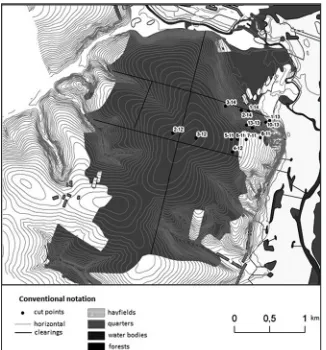
The points of the sections location on gray forest soils are reflected on the map of the territory of the soil survey [Figure 1]. The numbering of the sections reflects the year of the study of the soil section (for example, point 2-14 - is the second section in the order, established in 2014). Thus, the study used the following methods: Geoinformation mapping, as a cross-cutting at all stages; overlay analysis; and methods of automatic classification.
In parallel, the positional classifier was filled, and a matrix-legend was created with the usual text description of each classifier.
An assessment of the relief, ecological, and geological conditions of the studied area was carried out at the initial
Figure 1: Map of the studied area on the right bank of the
stage of the study, for the analysis of the state and dynamics of the fertility of gray forest soils in the subzone of a typical forest-steppe on the right bank of the Seversky Donets River. Based on the topographic map of the profiled section, a complex profile was compiled. To describe the terrain of the studied area, 3 hypsometric profiles were created as follows: A-B profile of the north-eastern exposure, E-G profile of the eastern exposure, and C-D profile of the north-north-eastern exposure. Determination of the slope steepness was carried out according to the procedure.[6] The terrain of the studied area is represented by the convex complex slopes.
RESULTS
The slope surface of the north-eastern exposure, profile A-B, varies from (1° to 18°), while the slope surface of the eastern exposure, profile E-G has a convex surface, the steepness varies from 0° to 18° and the slope profile of C-D north-north-eastern exposure has a convex surface, with the steepness varies from 0° to 18°.
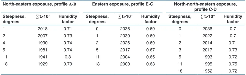
Karmanov’s and Bulgakov formula was used for calculating the transformation of temperature amount >10°, due to the redistribution of sunlight by the terrain.[10] The indicators of temperature amount and humidity factor for the profiles of different exposures are given in Table 1.
The evaluation of A-B profile of the north-eastern exposure showed that the greater the slope steepness, the higher the humidity factor (0.71-0.8); on the contrary, the amount of temperature >10° decreased from 2018 to 1929°. The slope of the north-eastern exposure is the wettest by the humidity factor. With an increase of the slope steepness of the eastern exposure of E-G profile, the humidity factor decreases (0.69-0.63) and the amount of temperature >10° decreases from 2036° to 2000°.
With an increase of the slope steepness of the north-north-eastern exposure of C-D profile to 2°, the amount of
temperature >10° for many years decreases from 2036° to 2014°; with an increase of the slope steepness from 2° to 3° the index value increases (from 2014° to 2017°), then again goes on decline; with an increase of the slope steepness from 5° to 11°, the index value increases (from 1993° to 1995°), and with an increase of the slope steepness more than 11°, the amount of temperature >10° decreases from 1995° to 1952°. The humidity factor increases with the slope steepness (0.7-0.75), and only at the end of the profile, it decreases to 0.72.
Thus, the distribution of the amount of multiyear temperatures >10°C under the conditions of the north-eastern slope has an inverse dependence, and the humidity factor shows a direct dependence. There is a decrease of the amount of multiyear temperatures >10°C and the humidity factor on the slope of the eastern exposure. The slope profile of the north-north-eastern exposure shows that the distribution of the temperature amount >10°C varies depending on the steepness, while the humidity factor varies insignificantly.
Upland and slope areas have a thick cover of loess-like loam, beneath them there are red-colored clays of the lower parts of the weathering crust.[11] Below there are gray-green clays with interlayers of loam, sand, and quartzite slabs. These deposits were formed on dense chalk.
Morphological properties of soils reflect the soil-forming process of gray forest soils in the south of the forest-steppe of the Central Russian Upland. Studied area refers to two types of terrain: Upland and slope. The soil cover is represented by dark gray and gray forest soils of heavy loamy and medium loamy granulometric composition. The confinedness of dark gray forest soils to upland and upper slope parts of the profiles is observed. The thickness of the humus horizon varies in the range from 42 cm to 52 cm. Silica powdering in the profile of dark gray soils is not pronounced. These soils were formed on loess-like loam and clays.
Gray forest soils were formed on slopes >5°. The thickness of the humus horizon decreased in accordance with the
Table 1: The indicators of temperature amount and humidity factor for the profiles of different exposures
Slope exposure
North-eastern exposure, profile А-В Eastern exposure, profile E-G North-north-eastern exposure,
profile C-D Steepness,
degrees ∑t>10° Humidity factor Steepness, degrees ∑t>10° Humidity factor Steepness, degrees ∑t>10° Humidity factor
1 2018 0.71 0 2036 0.69 0 2036 0.7
2 2007 0.73 1 2030 0.69 1 2022 0.7
4 1990 0.74 2 2026 0.69 2 2014 0.71
5 1981 0.74 5 2017 0.67 3 2017 0.73
11 1941 0.8 11 2004 0.65 5 1993 0.72
18 1929 0.79 18 2000 0.63 11 1995 0.75
increase of the slope steepness to 23 cm (on the slope with the steepness 18°). A clear diagnostic sign of these soils is the presence of silica powdering in the profile. The change in the granulometric composition from heavy loam to medium is observed.
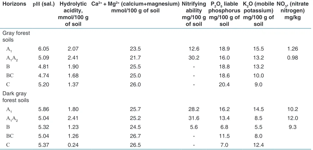
The dynamics of indicators, characterizing the fertility of the studied subtypes of dark gray and gray forest soils, are presented as averaged values for soil horizons [Table 2]. The fertility analysis of the studied subtypes of soils revealed that the pH (sal.) values in gray forest soils vary in the profile from 6.05 to 4.74 units. In the horizons B and BC, these indicators are the lowest and are equal to 4.81 and 4.74 units. These values indicate the medium acidity of the soil. In dark gray forest soils, pH (sal.) varies from 5.86 to 5.04 that indicates neutral and slightly acidity. The variation of the sign is insignificant. Hydrolytic acidity in gray forest soils of the profile decreases from 2.07 mmol/100 g of soil in the upper horizon (A1A2) to 1.37 mmol/100 g of soil in the lower horizon. Higher value of this indicator (2.41 mmol/100 g of soil) is fixed in the horizon A1A2. In the profile of dark gray forest soils, this value varies from 1.8 to 0.24 mmol/100 g of soil that is lower in absolute values than the previously subtype. A similar regularity can be seen in the increase of hydrolytic acidity values in the humus-eluvial horizon (2.41 mmol/100 g of soil).
The content of Ca2+ + Mg2+ is important for soils of the forest-steppe zone among the exchangeable cations. In the profile of gray forest soils, this value varies from 23.5 mmol/100 g of soil to 26.0 mmol/100 g of soil. Dark gray forest soils are characterized by a more uniform content of these cations in the soil profile (from 25.7 to 26.5 mmol/100 g of soil).
The nitrifying ability in dark gray forest soils in the upper horizons is 28.2 and 31.6 mg/100 g of soil, and in gray forest soil, this index varies from 12.6 to 30.2 mg/100 g of soil.
The content of fertilizer elements in gray forest soils is as follows: The content of liable phosphorus is in the range from 18.9 to 20.4 mg/100 g of soil, and the content of mobile potassium is from 15.5 to 9.0 mg/100 g of soil. In dark gray forest soils, the above indices are distributed as follows: Liable phosphorus - from 16.2 to 7.0 mg/100 g of soil and mobile potassium - from 14.5 to 5.5 mg/100 g of soil. The content of nitrate nitrogen in the gray forest soil in the upper horizon is much smaller than in the dark gray forest soil (1.26 and 10.2 mg/kg of soil, respectively).
DISCUSSION
The analysis of microclimatic characteristics of the type formation of gray forest soils in the subzone of typical forest-steppe on the right bank of the river Seversky Donets showed that the distribution of the temperature amount over 10°C by the hypsometric profile on the slope of the northeastern, eastern, and north-north-eastern exposure decreases with increasing the slope steepness. The humidity factor increases with the slope steepness in the north-eastern and north-north-eastern directions; the reverse pattern is noted for the north-north-eastern slope.
There is a definite regularity in the spatial arrangement of gray forest soils subtypes on the studied area. Dark-gray forest soils, formed in the upland and upper slope areas, with a thickness of humus horizon up to 52 cm, have a higher level of fertility. That is expressed in lower values of hydrolytic acidity (1.8
Table 2: Indicators of fertility of the studied soils
Horizons рН (sal.) Hydrolytic
acidity,
mmol/100 g
of soil
Ca2+ + Mg2+ (calcium+magnesium)
mmol/100 g of soil Nitrifying ability
mg/100 g
of soil
P2O5 liable
phosphorus
mg/100 g of
soil
K2O (mobile
potassium)
mg/100 g of
soil
NO3, (nitrate
nitrogen) mg/kg
Gray forest soils
А1 6.05 2.07 23.5 12.6 18.9 15.5 1.26
А1А2 5.09 2.41 21.7 30.2 16.0 13.2 0.98
В 4.81 1.90 25.5 ‑ 18.8 13.2
ВС 4.74 1.68 25.0 ‑ 18.6 10.0
С 5.20 1.37 26.0 ‑ 20.4 9.0
Dark gray forest soils
А1 5.86 1.80 25.7 28.2 16.2 14.5 10.2
А1А2 5.04 2.41 25.2 31.6 13.4 8.5 12.0
В 5.32 1.23 24.5 5.6 6.8 5.5 9.3
ВС 5.04 1.26 26.7 ‑ 11.5 8.0
mmol/100 g of soil), close to neutral reaction of the medium (5.86), a higher content of calcium and magnesium in the absorbing complex (25.7 mmol/100 g of oil). However, there is a very low content of liable phosphorus (16.2 mg/100 g of soil), mobile potassium (14.5 mg/100 g of soil), and nitrate nitrogen (10.2 mg/kg of soil).
Gray forest soils were formed on the steep slopes (from 5° to 18°). They have a lower thickness of humus horizon to 33 cm, and with the increase of the slope steepness, their granulometric composition varies from heavy loamy to medium loamy. The fertility of gray forest soils is characterized by a higher hydrolytic acidity (2.07 mmol/100 g of soil), and the content of calcium and magnesium is lower than in dark gray forest soils in the absorbing complex (23.5 mmol/100 g of soil). The degree of acidity is neutral (6.05). The contents of liable phosphorus (18.9 mg/100 g of soil) and mobile potassium (15.5 mg/100 g of soil) in gray forest soils are also very low, as the content of nitrate nitrogen (1.26 mg/kg of soil).
Thus, soil transformations, occurring against the background of one of the leading factors of soil formation - the climate, undoubtedly require further research in the conditions of the south of the Central Russian Upland forest-steppe, on the objects of gray forest soils, adapting to climatic changes.
CONCLUSIONS
1. The amount of active temperatures and humidity factor are the main microclimatic characteristics of gray forest soils formation in the subzone of typical forest-steppe, on the right bank of the river Seversky Donets. There is the decrease in the amount of multiyear temperature >10°C on the studied slopes, with an increase of their steepness, regardless of the exposure. The variation range of this value is from 2036° to 1929°. The humidity factor varies depending on the exposure of the slope. In the conditions of the slope of the north-eastern and north-north-eastern exposure, these values tend to increase from 0.70 to 0.80. On the slope of the eastern exposure, humidity factor decreases from 0.69 to 0.63, depending on the steepness of the surface.
2. The analysis of indicators, determining the general level of fertility of gray forest soils, shows their genesis and taxonomic affiliation. Dark gray forest soils, formed in the upland and upper slope areas, differ from gray forest soils by the thickness of the humus horizon (A1 + A1A2) - 52 cm (23 cm); hydrolytic acidity - 2.11 mmol/100 g of soil (2.24 mmol/100 g of soil); by the content of Ca2+ + Mg2+ - 25.5
mmol/100 g of soil (22.6 mmol/100 g of soil); nitrifying
ability - 29.9 mg/100 g of soil (21.4 mg/100 g of soil); and nitrate nitrogen - 11.1 mg/kg of soil (1.12 mg/kg of soil), respectively (based on the average values of the horizons A1 + A1A2).
REFERENCES
1. Porfiriev B.N. Climate Change and International Security. Moscow: LLC RIF “D’ART”; 2011. p. 290. 2. Akulov VV, Lebedeva MG, Krymskaya OV. Indicative
Properties of the Main Forest - Forming Species of the Belgorod Region and Regional Climatic Changes. In the Book: Regional Effects of Global Climate Change (Causes, Consequences, and Forecasts). Collection of Reports of the International Scientific Conference (Voronezh); 2012. p. 279.
3. Lebedeva MG, Krymskaya OV. The displaying of modern climatic changes in the Belgorod region. Belgorod State Univ Sci Bull Nat Sci 2008;3:188-97. 4. Smirnova LG, Chendev YG, Kukharuk NS, Tkachenko AV.
PH dynamics of typical chernozem under conditions of short-term climatic variability in agro landscapes of the south of the forest-steppe of the central Russian upland. Belgorod State Univ Sci Bull Nat Sci 2015;15:156-63. 5. Rysin LP, Rysin SL. Urban Forestry. Moscow:
Kottonmouth Kings (KMK); 2012. p. 240.
6. Smirnova LG, Narozhnyaya AG, Kukharuk NS, Ukrainskiy PA. Practical Work on Landscape Agriculture. Belgorod: Publishing House of BelSU; 2009. p. 63. 7. Dunaev AV, Dunaeva EN, Kalugina SV. Comparative
ecological assessment of the pediculate oak persistence to some diseases of trunk in the oak forests of the southern forest-steppe. Belgorod State Univ Sci Bull Nat Sci 2011;3:49-58.
8. Dunaev AV, Dunaeva EN, Kalugina SV. Forest and people: Anthropogenic loss of positional stability by the oak forests of the forest-steppe. Belgorod State Univ Sci Bull Nat Sci 2014;10:34-42.
9. Smirnova LG, Kukharuk NS, Lisetskiy FN. Database of soil survey of the “Nezhegol” nature park, using geoinformatics and remote sensing methods. № 8423. May 31, 2007. Application software. Database. Topologies Integr Circuits 2007;2:375.
10. Karmanov II, Bulgakov DS. Landscaping and agricultural typification of the territory. Method Book. Moscow: Russian Academy of Agricultural Sciences; 1997. p. 110.