AUTUMN 2017, Vol 3, No 2, JOURNAL OF HYDRAULIC STRUCTURES Shahid Chamran University of Ahvaz
Journal of Hydraulic Structures J. Hydraul. Struct., 2017; 3(2):32-46
DOI: 10.22055/jhs.2018.24900.1065
Experimental Study of the Effect of Base-level fall at the
Beginning of the Bend on Reduction of Scour around a
Rectangular Bridge Pier Located in the 180 Degree Sharp Bend
Mohammad Vaghefi1 Mohammad Moghanloo2 Danesh Dehghan2 Arsalan Keshavarz2
Abstract
Base-level fall in river beds occurs due to varying natural or unnatural causes. Base-level fall causes the change in the behavior of flow at the location of drop in base-level. In such situations, most of scour occur at the foot of the slope, and slope wall retreats in the upstream direction. This phenomenon widens the wall of the river bank, thus leading to its destruction. The amount of bed topography variations and scour around a rectangular bridge pier with an oblong nose located in the 90 degree angle of a 180 degree sharp bend was studied in this work by generating base-level fall at the beginning of the 180 degree sharp bend, and it was compared with a case without a base-level fall. The results indicated that in the case of base-level fall at the upstream side of the bridge pier, increase in flow depth, as well as reduction in velocity at the area around the pier, is observed, and the maximum depth of scour hole and the volume of scour hole around the pier respectively reduce by 73 and 97% in comparison with those in the case where no base-level fall occurs.
Keywords:180 degree sharp bend, base-level fall, scour, bridge pier, topography.
Received: 18 October 2017; Accepted: 25 November 2017
1. Introduction
As in all the other natural phenomena, rivers tend to preserve their sustainability system. Hence, any geometric or hydraulic change in rivers entails a dynamic response from the river in order to restore equilibrium. Such a response is at times too widespread and uncontrollable. Base-level drop and bed erosion in rivers result in an abrupt change in bed slope and generation of knickpoints, all leading to base-level fall. In geomorphology, knickpoints are a part of rivers
1 Civil Engineering Department, Persian Gulf University, Bushehr, Iran. [email protected]
(Corresponding author)
AUTUMN 2017, Vol 3, No 2, JOURNAL OF HYDRAULIC STRUCTURES Shahid Chamran University of Ahvaz
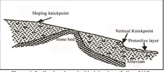
or channels, causing discontinuities on the slope and bed level of channels, and they occur vertically or inclined on channel bed.
Figure 1. Inclined and vertical knickpoints (Julien, 2002)
Knickpoints make river beds unstable. River system confronts bed degradation and erosion at the upstream, and sedimentation at the downstream sides of the knickpoint. This process means expansion and migration of the knickpoint, damage to surrounding structures and lands, and bed topography variations. Several studies have been conducted on bed level variations before, a summary of which is presented in the following:
AUTUMN 2017, Vol 3, No 2, JOURNAL OF HYDRAULIC STRUCTURES Shahid Chamran University of Ahvaz
migrating upstream. The drop caused numerous staircase knickpoints on the bed of the channel, all of which retreated in upstream direction, and a hydraulic jump occurred on every stair. The results indicated that an abrupt change in base-level led to conversion of the supercritical flow into a subcritical flow at the downstream side of the slope, thus reducing bed shear stress of the flow at the downstream side of the slope. Grimaud et al (2016) experimentally examined the profile of river and knickpoint, and concluded that for a constant rate of base-level fall, knickpoints of similar forms occur. Retreat velocity, the front slope angle, and the hole depth at the downstream side of the knickpoint highly depend upon the structure of bed material. Also, time intervals between knickpoint formations depend on bed thickness and rate of base-level drop. Meandering rivers are the most common type of rivers in plan. However, a comprehensive study is yet required to be conducted on base-level variations in a bend.
The current study experimentally addresses a method of preventing destruction of downstream structures, and retreating erosion. In this method, the amount of local scour around a rectangular bridge pier with an oblong nose located in the 90 degree position is examined by dropping base level at the beginning of a 180 degree sharp bend and creating a base-level fall. Bed topography variations, material displacement at the beginning of the bend and the sideway banks, and the difference in the maximum scour, dimensions, and the volume of scour hole were studied.
2. Materials and Methods
Experiments were carried out in a bended channel with a 180 degree bend. Figure (2) depicts the channel. This rectangular channel is 1 meter wide and 70 cm high at the section. The straight upstream- and downstream-directed paths are respectively 6.5, and 5 meters long. The central curvature radius of the bend is 2 meters. With a ratio of R/B=2, according to classification proposed by Leschziner & Rodi (1979), this channel falls into the category of sharp bends, where R denotes the central radius of the bend, and B the channel width. Considering the research efforts by Chiew & Melville (1987), the standard deviation of sediment particles must be less than 1.3 in order to preserve the effect of non-uniformity of particles on scour. Also, according to experiments conducted by Raudkivi & Ettema (1983) aiming at prevention of ripple formation upstream, the average diameter of the particles must not be smaller than 0.7 mm. Hence, particles with an average diameter of 1.5 mm and standard deviation of 1.14 were employed in this laboratory. All the experiments were conducted under inception motion conditions with a ratio of flow velocity to critical velocity (U/Uc) equal to 0.97.According to Oliveto & Hager (2002), in order to prevent
AUTUMN 2017, Vol 3, No 2, JOURNAL OF HYDRAULIC STRUCTURES Shahid Chamran University of Ahvaz
Figure 2. Laboratory flume employed by Vaghefi et al (2016)
As suggested by Chiew & Melville (1987), pier diameter must not exceed 10% of channel width, so that the effect of walls on local scour around the pier will fade. Additionally, as recommended by Melvill & Sutherland (1988), the length of the rectangular pier must be at least 3 times its width. Therefore, a 20 cm long, and 5 cm wide pier (L/b=4) was used for the experiments, where L denotes length and b is the pier width. The pier is made of PVC, and cut by CNC. Prior to the experiments, the whole bed was cleared by a metal plate connected to a cart moving on the rail, so that the upstream straight channel was covered by 30 cm of material, and the bed from the beginning of the bend to the end of the downstream straight path was covered by 20 cm of material. Then, the pump was turned on, and water was slowly let into the channel. As water level rose, when the sediments were evidently wet, and in a period of about 40 minutes, the motor rotation was gradually increased up to 70 liters per second. Also, at the end of the experiment, when the pump was turned off, and after 2 hours of full drainage, bed topography was collected by using ±1 mm laser meter. Figure (3) illustrates base-level drop at the beginning of the bend. Such a drop encompasses the beginning of the bend to the end of the downstream straight path. Base-level drop was achieved with a 20 degree angle (slope of 36%) in proportion to horizon, and a 30-meter-long sloped.
AUTUMN 2017, Vol 3, No 2, JOURNAL OF HYDRAULIC STRUCTURES Shahid Chamran University of Ahvaz
Figure 4. A view of the rectangular pier with an oblong nose, located in the 90 degree position in the 180 degree sharp bend
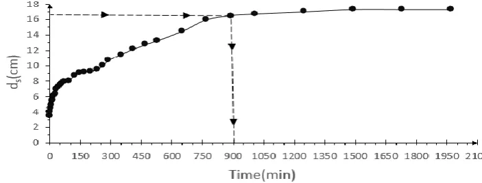
In the first stage, a 34-hour-long equilibrium time test was carried out on the oblong-nosed rectangular pier located in the 90 degree bend without changing the base level in order to determine the relative equilibrium time for conducting the experiments. In the equilibrium time test, increase in the maximum scour depth (ds) was continuously measured in time.
Measurement lasted until 4 hours of consecutive intervals did not reveal any perceptible change in the maximum scour depth. As is observed in Figure (5), approximately 95% of the maximum scour occurred in the first 15 hours of the experiment, which is in agreement with the results of Melville & Chiew (1999). Therefore, 15 hours was selected as the relative equilibrium time for conducting each experiment.
Figure 5. Variations of the maximum scour depth in time in the test on equilibrium time
Three tests were run in order to conduct the experiments and study the effect of base-level fall on reduction of scour around the rectangular bridge pier, and bed topography variations. First, a test was conducted in order to investigate bed topography variations in the bed without creating base-level fall, and with a bend empty of pier along the flow. This aimed to help identify the behavior of the bend when there are no base-level changes or existing hydraulic structures, under the influence of hydraulic conditions. The second test was run in order to examine bed topography variations in the bend by placing the rectangular bridge pier with an oblong nose in the 90 degree position of the bend without creating base-level fall.
AUTUMN 2017, Vol 3, No 2, JOURNAL OF HYDRAULIC STRUCTURES Shahid Chamran University of Ahvaz
without a pier. The third test was conducted with the aim of examining the effect of drop on bed topography of the bend and scour around the rectangular bridge pier. The results are addressed in the following section.
3. Results and Discussion
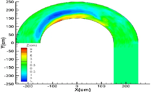
After determination of the relative equilibrium time, the experiment was conducted in an empty bend without a pier in order to provide a better understanding of flow behavior and bed topography variations in the bend. Bed topography after equilibrium time is presented in Figure (6). As is evident in the figure, bed topography in the bend is accompanied by sedimentation at the inner bank as well as erosion at the outer bank, due to formation of helical flows.
Figure 6. Bed topography variations in the case of empty bend (without a pier)
AUTUMN 2017, Vol 3, No 2, JOURNAL OF HYDRAULIC STRUCTURES Shahid Chamran University of Ahvaz
(
a
)
(
b
)
(
c
)
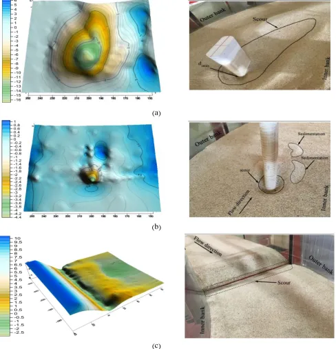
Figure 7. bed topography variations of the experiment on the oblong-nosed rectangular pier in the 90 degree position of the bend a) without base-level drop, b) with base-level drop, and c) for the hole created at the
beginning of the bend due to water crossing the inclined surface
As is seen in Figures 7-a, and 7-b, the maximum scour at the pier nose (the 87 degree angle) occurred in both experiments. This maximum scour depth in the case of no base-level fall was equal to 3.3 times the pier width, and it was equal to 0.9 times the pier width in the case of base-level fall. Comparison reveals a 73% reduction in the maximum scour depth due to base-base-level drop. This could be due to the fact that, according to continuity equation, with base-level drop and raise in water depth, the velocity of water reduces upon entering the bend, thus reducing the strength of horseshoe vortices generated as a result of the collision of water with the pier and helical flows. This has led to a significant reduction in the maximum depth and width of scour hole, and decrease in sediments advancing towards the downstream side of the pier in the case of base-level drop. It should be noted that at the onset of the experiment at the beginning of the bend, a hole with the maximum depth of 0.6 times the pier width is created due to water crossing an inclined surface with formation of falling submerged flows (Figure 7-c).
AUTUMN 2017, Vol 3, No 2, JOURNAL OF HYDRAULIC STRUCTURES Shahid Chamran University of Ahvaz
more precise calculations in measuring the volume of the hole, and drawing the figures. As presented in Figures 8-a and 8-b, the volume of the hole created around the pier in the case of no base-level drop and in the case of base-level drop, is respectively around 28750 and 750 𝑐𝑚3, equal to 230 and 6 times the third power of the pier width. Also, according to Figure 8-c, due to falling submerged flow crossing the knick point and the inclined surface, a wide hole of 3500𝑐𝑚3, equal to 28 times the third power of the pier width, is formed at the beginning of the bend.
AUTUMN 2017, Vol 3, No 2, JOURNAL OF HYDRAULIC STRUCTURES Shahid Chamran University of Ahvaz
(
a
)
(
b
)
(
c
)
Figure 8. Scour holes created a) around the bridge pier in the case of no base-level drop, b) around the bridge pier in the case of level drop, and c) at the beginning of the bend in the case of
base-level drop
AUTUMN 2017, Vol 3, No 2, JOURNAL OF HYDRAULIC STRUCTURES Shahid Chamran University of Ahvaz
the pier width in the case of base-level drop. However, in the case of no base-level drop, in the same situation, the scour hole lasts at a depth equal to 2.22 times the pier width. The maximum sedimentation at this section in the case of an empty bend has occurred 1.06 times the pier depth at a distance of 0.05 times the channel width from the inner bank. At a distance of 17 times the pier width downstream, at the 115 degree section, as in Figure 9-f, in the case of no base-level drop, sedimentation piles are formed at intervals equal to 0.1 and 0.6 times the channel width from the inner bank with a height of 1.28 and 0.86 times the pier width. Also, presence of secondary flows leads to creation of the secondary scour hole as deep as 0.66 times the pier width at a distance of 0.22 times the channel width from the outer bank. Under the empty bend conditions, the sediment pile is formed with a height of 0.6 times the pier width at a distance of 0.025 times the channel width from the inner bank, and the scour hole occurs as deep as 0.28 times the pier width at a distance of 0.3 times the channel width from the inner bank.
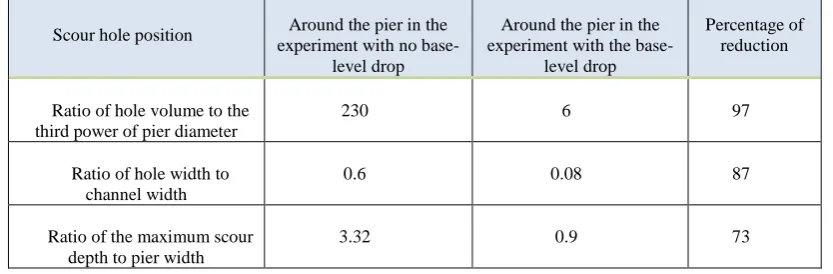
Table (1) presents the size of the scour hole nondimensionalized with the third power of the pier diameter, and the width of scour hole nondimensionalized with the channel width. According to this table, due to the base-level drop, the size and maximum width of the scour hole have reduced by respectively 97 and 87% in comparison to the case of no base-level drop.
Table 1. The volume of the scour hole nondimensionalized with the third power of the pier diameter, and the width of the scour hole nondimensionalized with the channel width
Scour hole position Around the pier in the experiment with no
base-level drop
Around the pier in the experiment with the
base-level drop
Percentage of reduction
Ratio of hole volume to the third power of pier diameter
230 6 97
Ratio of hole width to channel width
0.6 0.08 87
Ratio of the maximum scour depth to pier width
3.32 0.9 73
AUTUMN 2017, Vol 3, No 2, JOURNAL OF HYDRAULIC STRUCTURES Shahid Chamran University of Ahvaz
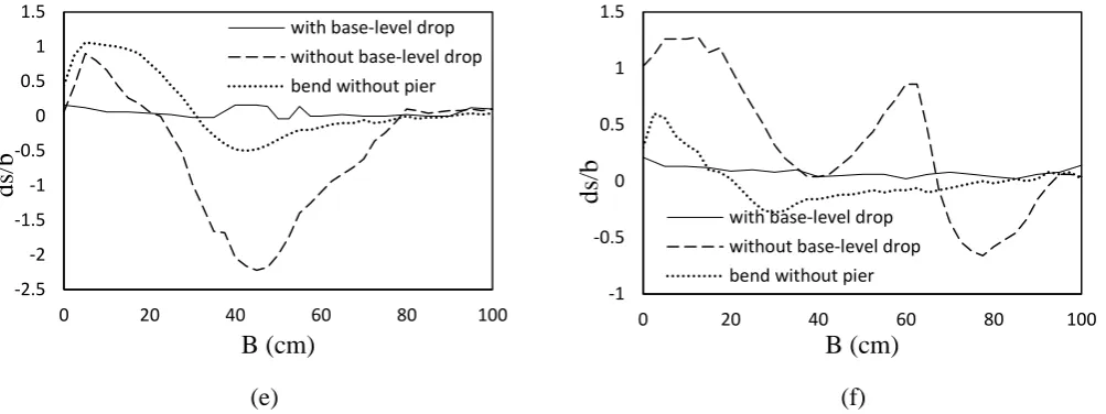
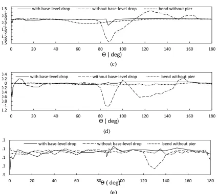
is formed from the 75 to 110 degree sections of the bend. The maximum depth of this scour is 3.32 times the pier width in the 87 degree section of the bend (the pier nose). The sediments washed at the pier nose are piled up from the 115 to 145 degree sections of the bend. The maximum height of sedimentation is equal to 1.24 times the pier width in the 125 degree section of the bend. However, in the case of base-level drop, the scour hole is formed from the 85 to 95 degree sections of the bend. Also, the maximum depth of this scour occurs in the 87 degree section of the bend (the pier nose), as large as 0.9 times the pier width. In the case of empty bend, the maximum scour depth of 0.66 times the pier width occurred in the 75 degree section of the bend. As is evident in Figure 10-e, in the case of no base-level drop, after the main scour hole, a secondary scour hole is formed at the distance between the 110 and 145 degree angles due to water falling from sediment piles.
(
b)
(
a)
(
d)
(
c)
-1 -0.5 0 0.5 1 1.5 20 20 40 60 80 100
ds/b
B (cm)
with base-level drop without base-level drop bend without pier
-0.7 -0.5 -0.3 -0.1 0.1 0.3
0 20 40 60 80 100
ds/b
B (cm)
with base-level drop without base-level drop bend without pier
-3.5 -3 -2.5 -2 -1.5 -1 -0.5 0 0.5 1
0 20 40 60 80 100
ds/b
B (cm)
with base-level drop without base-level drop bend without pier
-3 -2.5 -2 -1.5 -1 -0.5 0 0.5 1 1.5
0 20 40 60 80 100
ds/b
B (cm)
AUTUMN 2017, Vol 3, No 2, JOURNAL OF HYDRAULIC STRUCTURES Shahid Chamran University of Ahvaz
(f) (e)
Figure 9. cross sections of a) the beginning of the bend, b) 17 times the pier width at the upstream side of the pier (65 degrees), c) 3 times the pier width at the upstream side of the pier (85 degrees), d) the pier nose, e) 3 times the pier width at
the downstream side of the pier (95 degrees), and f) 17 times the pier width at the downstream side of the pier (115 degrees)
(
a)
(
b)
-1 -0.5 0 0.5 1 1.50 20 40 60 80 100
ds/b
B (cm)
with base-level drop without base-level drop bend without pier -2.5 -2 -1.5 -1 -0.5 0 0.5 1 1.5
0 20 40 60 80 100
ds/b
B (cm)
with base-level drop without base-level drop bend without pier
-0.5 -0.1 0.3 0.7 1.1 1.5 1.9
0 20 40 60 80 100 120 140 160 180
ds/b
Ɵ
( deg)
with base-level drop without base-level drop bend without pier
-1 0 1 2
0 20 40 60 80 100 120 140 160 180
ds/b
Ɵ
( deg)
AUTUMN 2017, Vol 3, No 2, JOURNAL OF HYDRAULIC STRUCTURES Shahid Chamran University of Ahvaz
(
c
)
(
d
)
(
e
)
Figure 10. longitudinal sections at distances of a) 5, b) 25, c) 50, d) 75, and e) 95% of the channel width from the inner bank
The maximum depth of the secondary scour hole, equal to 0.6 times the pier width, occurred in the 115 degree section. In the case of base-level drop at the beginning of the bend, a scour hole is created with the maximum depth of 0.56 times the pier width. In addition, the sediment pile with a height of 0.2 times the pier width is formed in the 7 degree section of the bend. In the case of empty bend, the bed variations along the bend are insignificant. According to Figure 10-d, in the case of no base-level drop, a scour hole with the maximum depth of 0.36 times the pier width is created in the 130 degree section of the bend, in the vicinity of the outer bank, under the influence of the secondary flows, and their interaction with the longitudinal flow and formation of a helical flow. In the case of base-level drop at the beginning of the bend, a scour hole has occurred with a depth of 0.38 times the pier width, and bed variations after this scour hole are insignificant to the end of the bend. Also, there have been few changes in the case of empty bend.
-3.5-3 -2.5-2 -1.5-1 -0.50 0.51 1.5
0 20 40 60 80 100 120 140 160 180
ds/b
Ɵ
( deg)
with base-level drop without base-level drop bend without pier
-1.2-1 -0.8 -0.6 -0.4 -0.20 0.2 0.4
0 20 40 60 80 100 120 140 160 180
ds/b
Ɵ
( deg)
with base-level drop without base-level drop bend without pier
-0.5 -0.3 -0.1 0.1 0.3
0 20 40 60 80 100 120 140 160 180
ds/b
Ɵ
( deg)
AUTUMN 2017, Vol 3, No 2, JOURNAL OF HYDRAULIC STRUCTURES Shahid Chamran University of Ahvaz
4. Conclusion
This paper addressed the effect of base-level fall on scour around a rectangular bridge pier located in the 90 degree angle of a 180 degree sharp bend. The most important findings are as follows:
The maximum scour occurred for 16.6 cm, equal to 3.32 times the pier width at the pier nose after installation of the pier in the intended position. However, with the position of the pier, after applying base-level fall, the maximum scour depth occurred for 4.5 cm, equal to 0.9 times the pier width, the fact which indicates a 73% reduction in the scour hole around the pier. In both cases, the maximum scour depth occurred at the nose of the pier. After creating a base-level drop, the volume of scour hole around the pier reduced by 97%, and a wide scour hole with a size of 28 times the third power of the pier width, and the maximum depth of 0.6 times the pier width formed at the downstream side of the slope.
5. Reference
1. Begin, Z. E. B., Schumm, S. A. and Meyer, D. F. (1980). "Knickpoint migration due to base
level lowering." Journal of the Waterway, Port, Coastal and Ocean Division, 106(3), 369-388.
2. Brush, L.M. and Wolman, M.G. (1960(. Knickpoint behavior in non-cohesive material: A " laboratory study." Geological Society of America Bulletin, 71: 59-74.
3. Cantelli, A. and Muto T. (2014). "Multiple knickpoints in an alluvial river generated by a single instantaneous drop in base level: experimental investigation." Earth Surf. Dynam, 2: 271–278.
4. Chiew, Y.M. and Melville, B.W. (1987). "Local scour around bridge piers." Journal of Hydraulic Research, 25 (1), 15–26.
5. Garcia, M. H. and G. Parker. )1993(."Experimental on the entailment of sediment into suspention by a dense bottom current." J. Geophys.Res. (Oceans) 98:4793-4807.
6. Grimaud, J.L., Paola1, C. and Voller, V. (2016). "Experimental migration of knickpoints: influence of style of base-level fall and bed lithology." Earth Surf. Dynam, 4: 11–23.
7. Holland, W.N. and Pickup, G. (1976). "Flume study of knickpoint development in stratified sediment." Geological Society of America Bulletin, 87: 76-82.
8. Julien, P. Y. (2002). "River mechanics." Cambridge University Press.
9. Leschziner, M. A. and Rodi, W. (1979). "Calculation of strongly curved open channel flow." Journal of the Hydraulics Division, 105 (10), 1297–1314.
10. May, J.H. (1989). "Report 4: Geologic and hydrodynamic controls on the mechanics of knickpoint migration." U.S. Army Engineer Waterways Experiment Station, Vicksburg, MS. 11. Melville, B.W. and Chiew, Y.M., (1999), "Time Scale for Local Scour Depth at Bridge
Piers." Journal of Hydraulic Engineering, ASCE, Vol.125, No.1, 59-65.
12. Melville B. W. and Sutherland A. J. (1988). "Design method for local scour at bridge piers." American Society of Civil Engineering. Journal of the Hydraulics Division, Vol. 114, No. 10, pp. 1210–1225.
13. Migeon, S., T. Mulder., B. Savoye. and F. Sage. (2011). "Hydrodynamic processes, velocity structure and stratification in natural turbidity currents: results inferred from field data in the turbidite system." J. Sedimen Geo. 245:48-62.
14. Oliveto, G. and Hager, W.H., (2002). "Temporal evolution of clear-water pier and abutment scour." Journal of Hydraulic Engineering, 128 (9), 811–820.
AUTUMN 2017, Vol 3, No 2, JOURNAL OF HYDRAULIC STRUCTURES Shahid Chamran University of Ahvaz
16. Turmel, D., Locat, J. and Parker, G. (2012). "Upstream migration of knickpoints: geotechnical considerations." In Submarine Mass Movements and Their Consequences (pp. 123-132).