Volume 6, Issue 6 [June. 2017] PP: 22-26
Accessibility Settlements at the Tallo River Estuary in
Makassar City South Sulawesi Province
Rani Maulina Delima
1,Shirly Wunas
2,M. Yamin Jinca
31Master Degree Of Transportation Planning, Faculty Of Postgraduate, Hasanuddin University, 2
Professor, Urban And Regional Planning, Hasanuddin University, Makassar-Indonesia 2Professor, For Infrastructure And Transportation Planning, Hasanuddin University,
Makassar - Indonesia
Abstract:
Land transfer functions of the settlements into warehouses and industrial estates have increased very strongly in the last 10-15 years of the Tallo River Estuary. Currently the Tallo River Watershed is directed as a strategic area of the water transport development. This research aims to: 1) identify the conditions of settlements and road networks at the Tallo River Estuary; 2) analyze the accessibility of land and river transportation services to reach the estuary and 3) propose the concept of integration between residential settlements and transportation network systems at the Tallo River Estuary. The research was conducted by survey technique, direct observation and interviews of residents within the estuary. This analysis is quantitative-descriptive and spatial. The research sites are located in the administrative area of Tallo sub-district and Buloa sub-districts in Makassar City. The analysis is divided into 3 segments: buildings on water, buildings on the river boundary (0-15 m from the riverbanks) and buildings located on land (15-270 m from the riverbank). The results of the analysis show that: 1) the condition of the settlement at the Tallo River Estuary, which is on the water, the shape of the building is a stage house served by the road network of the (wood/bamboo). The settlements within the river border area, the shape of the building is in the form of houses on stilts that have been built under the pavement, served by paving blocks, and settlements of the mainland, the form of stone houses on the ground, served by the paving block. 2) Access to the Tallo River Estuary settlement area, can be reached by land and river route. 3) The concept of integration can be directed by a modal displacement node in the space connecting the settlement with the road and dock networks.Keywords:
Accessibility, Settlement, Transportation, Tallo RiverI.
INTRODUCTION
Provision of regional infrastructure and structure of transportation should be able to provide increased accessibility and mobility of the community in supporting the improvement of regional economic development and local communities. Accessibility is a concept that incorporates a land use arrangement system with a transport network system. Accessibility is an interaction of inter-land use interacting with each other, and it can be assessed to be 'easy' or 'difficult' the location is achieved through a transport network system. Accessibility is a measure of ease of reaching a place [1].
The Tallo River has a function and a very important role in the development of Makassar city, so it must be preserved and improved river functions. For the land use at the river estuary in addition to the settlement there is a complex of Tallo King’s Tomb which is a historical heritage used as a tourist attraction. As urban growth and population increases, new settlements grow uncontrollably along the river, so that some rivers lose their function and degrade their environmental quality [2,3].
The regulation of Public Works and Housing No. 28/PRT/M/2015 describes the determination of the river boundary line, that in the case of river utilization, the prohibition of building as protection of embankment that functions as flood control, but some facts show the development of fishermen settlements, embankment farmers and laborers informally in the area, with a disorganized and disorganized building structure. In addition, unsuitable land use, lack of service centers in residential areas and limited accessibility have become a problem in the estuary of the Tallo River [4,5].
II.
METDHOLOGY
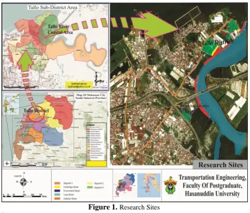
The location of the research was conducted on the settlements at the Tallo River Estuary, which is administratively located in Tallo and Buloa Sub-districts as shown in Figure 1.
Figure 1.
Research SitesSource:
The results of analysis, 2017Data were obtained from survey techniques, direct observation and in-depth interviews of residents within the Tallo River estuary estates. Document data obtained from the related institution in the form of location data and status of Sub-District in Tallo District. The report of Action Plans for Settlement Environment Arrangements (APFSEA) is a Priority Area of Tallo sub-district, Spatial Plans of Makassar City and Local Transportation in Makassar City and Ministerial Regulation about the river boundary line. This research uses descriptive-quantitative analysis techniques and to identify the condition of settlements and road networks at the Tallo River Estuary. Spatial analysis and accessibility to identify land and river transport networks to reach Tallo River estuary settlements, and to direct the concept of integration between residential and transport network systems. The settlement of the Tallo River Estuary was analyzed by descriptive analysis and accessibility index.
III.
RESULTS AND DISCUSSION
Identification of Settlement and Road Network Conditions of the Tallo River Estuary
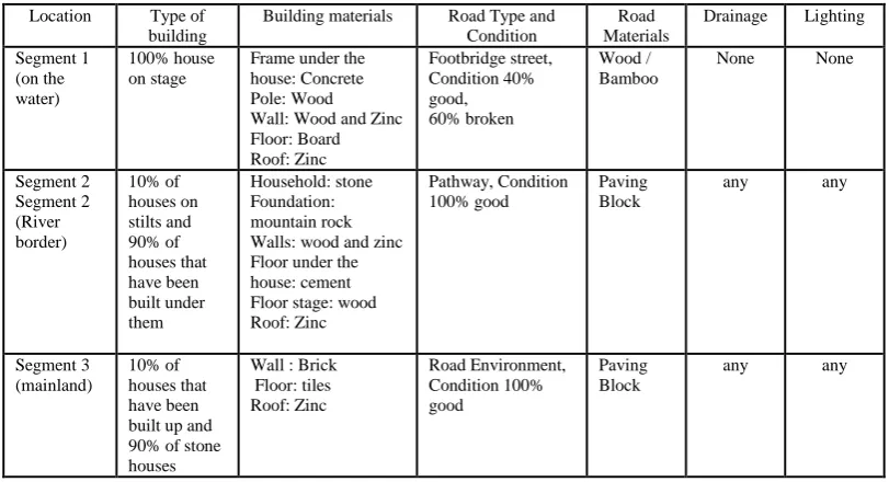
1-2 m with good 100% road condition. There are drainage and street lights whose cables come from inside the house.
The type of building on the segment 3 (mainland) is 90% stone houses built above ground, brick wall, tile floor and zinc roof. The settlement is served by an environmental road made of paving block with the width of 1-3 m with good 100% road condition. There are drainage and street lights. In general the conditions of settlements and road networks can be seen in Table 2.
Table 2.
Condition of settlements and road networksLocation Type of building
Building materials Road Type and Condition
Road Materials
Drainage Lighting
Segment 1 (on the water)
100% house on stage
Frame under the house: Concrete Pole: Wood Wall: Wood and Zinc Floor: Board Roof: Zinc Footbridge street, Condition 40% good, 60% broken Wood / Bamboo
None None
Segment 2 Segment 2 (River border) 10% of houses on stilts and 90% of houses that have been built under them Household: stone Foundation: mountain rock Walls: wood and zinc Floor under the house: cement Floor stage: wood Roof: Zinc
Pathway, Condition 100% good
Paving Block
any any
Segment 3 (mainland)
10% of houses that have been built up and 90% of stone houses
Wall : Brick Floor: tiles Roof: Zinc Road Environment, Condition 100% good Paving Block
any any
Source:
The results of the analysis, 2017There is no service center such as education, health and office facilities in the settlement area at the Tallo River Estuary, so people tend to use public transport and private vehicles as the main transportation to reach the facility compared to walking.
Accessibility of the Land and River Transport Service to Reach the Settlement Area at the Tallo
River Estuary
Tallo District is 8.75 km², with a population of 138,000, and population density of 15,771 people/km² (>5,000 souls/km²). The entire road length of Tallo District is 27.097 km, with the accessibility index of 3.09 so that it has qualified for the Minimum Service Standards (MSS) accessibility >1,5. This shows that the road network service in Tallo District has a high accessibility index, indicating the distance between the service centers and the condition of the road network infrastructure is very good. In general, the Tallo River Estuary settlement area is accessible by the land and river routes. The land route is served by two road networks of collectors, namely the road of Sultan Abdullah Raya and Teuku Umar Street. Both roads are traversed by city transport (public transport 'route C (Makassar Mall-Tallo)). The river route can be accessed through 4 docks in the Tallo watershed, serving as a location for inter-modal transportation (inland transport modes to the river transportation modes and otherwise). The settlements at the Tallo Estuary are served by Tallo Pier and Buloa Pier, by transport routes from the estuary of the Tallo River to Lakkang Island and Kera-Kera Island [6].
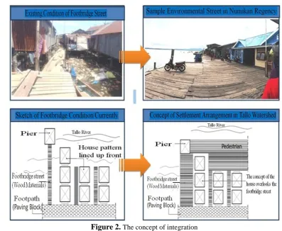
Integration Concept
Figure 2.
The concept of integrationAccording to the analysis, there are some access to the settlement, but there is no transportation as terminal or halt, which can facilitate the population to do the mode transfer, then the concept of improvement of transportation systems as shown in Figure 3, can be made a halt and signpost (location of tourism potential) So that people are more aware of the existence of a tourist attraction at the Tallo River Estuary in Makassar City.
Figure 3.
The concept of halts and signpostsIV.
CONCLUSION
connecting the settlement with the road and pier network in the form of making pedestrian lines along the settlement and arranging the facade of the building facing the path of the bridge for easy access in and out of the house.
REFERENCES
[1]. Awaluddin A., 2010. Developing Accessibility of Underdeveloped Regions in North Luwu Regency. Hasanuddin University Makassar.
[2]. Ali M. et al, 2016. Study of Tallo River Potential of Makassar City as Tourism Attractions with Revitalization Concept. IPLBI Scientific Meeting 2016. Makassar
[3]. Goenmiandari B., 2010. Concept of Settlement Arrangement in Banjarmasin City based on Local Culture. National Seminar on Housing in Urban Development
[4]. Regulation of the Minister of Public Works and Housing No. 28/PRT/M/2015 Year 2015 on Stipulation of River Border Line and Border Line Lake, 2015, Indonesia.
[5]. Arifuddin, et al. 2013. Tallo River Region Development: An Effort to Improve Quality of Makassar City. Proceeding of the PLBI Scientific Meeting in 2013. Makassar.