0468
A RACE WITH TIME IN THE EASTERN MEDITERRANEAN REGION
Walter W HAYS1
SUMMARY
The August 17, 1999 Izmit, Turkey earthquake disaster demonstrated the need for accelerating regional programs such as, “Reduction of Earthquake Losses in the Eastern Mediterranean Region” (RELEMR), in order to win the race with time. RELEMR has been sustained since 1993 under the coordination of the U.S. Geological Survey (USGS) and the United Nations Educational, Scientific and Cultural Organization (UNESCO). Technical assistance has been provided by the European-Mediterranean Seismological Center (EMSC) and, since 1996, by the Lawrence Livermore National Laboratory (LLNL). The goal of RELEMR is to promote collaboration between all EMR countries, earth science organizations, seismic network operators, urban planners, engineers as they work together to improve the capacity to create and enforce modern building codes based on modern ground shaking hazard maps in the race with time to achieve sustainable development in a geographic region facing future earthquake disasters. Initially, the program focused on the Eastern Mediterranean Region (EMR) comprised of Turkey, Lebanon, Cyprus, Syria, Jordan, Israel, Palestinian Authority, Egypt, Saudi Arabia, and Yemen, but it has been extended to include the Palestinian Authority and now the entire Mediterranean region, involving France, Algeria, Tunisia, Morocco, Italy, and Spain. Because of the geological setting and regional tectonics, the Mediterranean region has been subjected to many damaging earthquakes, with great loss of life and property. In the EMR, earthquakes are associated mainly with the northward movement of the Arabian plate and its collision with the Eurasian plate; in the WMR, with the collision of the African and Eurasian plate. The seismicity, geologic field studies, and post-earthquake studies, in the region all indicate that the EMR and the WMR will again experience damaging earthquakes.
INTRODUCTION
The Arabian plate is the dominant geological feature in the Eastern Mediterranean Region (EMR) (Figure 1). The 1,000 km-long Dead Sea transform fault system, a part of the complex western boundary of the Arabian plate, and the 1,000 km-long North Anatolian fault system, a part of the complex northern plate boundary, are two of the world’s most notable strike-slip faults. Although not the only sources of earthquakes in the EMR, both features are principal sources of the earthquake activity. The western boundary of the Arabian plate is complex, encompassing zones of sea-floor spreading in the Red Sea, the Dead Sea transform, and a zone of plate convergence in Turkey. The Dead Sea transform fault system exhibits left-lateral slip, with the east side moving northward relative to the west side. Total displacement is estimated at about 107 km since Oligocene time, with an annual rate of about 0.5 cm over the last 7 to 10 million years.
In the Western Mediterranean region (WMR), the earthquake activity is associated with the ongoing collision in the vicinity of the Mediterranean Sea of the northward moving African plate and the southward moving Eurasian plate.
RECENT DAMAGING EARTHQUAKES IN THE REGION
Eight damaging earthquakes having epicenters in Turkey, offshore Cyprus, Egypt, and the central Gulf of Aqaba have occurred in the region since RELEMR was initiated in 1993. The two largest—the August 17, 1999 Izmit
earthquake and the November 22, 1995 Gulf of Aqaba earthquake—are reminders of how large and how devastating EMR earthquakes can be to people and regional development. The magnitude 7.8 Izmit earthquake [ASCE, 1999] struck the most populous region of Turkey at 3:02 a m on August 17, 1999. Towns near the epicenter, such as Izmit, Yolova, Golcuk, Derince, Akarya , and other towns and cities along the Izmit Korfexi Bay in the Sea of Marmara, southeast of Istanbul, were hit hard. Strong ground shaking generated by the main shock and aftershock sequence, ground failure, and tsunami wave run up damaged or destroyed more than one hundred thousand homes and buildings in the region along with community infrastructure providing the essential services of supply, disposal, transportation, and communication. Current estimates indicate that the death toll may exceed 35,000, which would make the Izmit earthquake the fourteenth most destructive earthquake disaster this century. Estimates of the costs of recovery and reconstruction currently reach $ 25 billion. The magnitude 7.2 Gulf of Aqaba event caused damage in nearby communities in Jordan, Egypt, Israel, and Saudi Arabia, and was felt for more than 700 km from the epicenter. An aftershock sequence lasted for more than 1 year with numerous shocks exceeding Ms 5.0.
REGIONAL COLLLABORATION
The program, “Reduction of Earthquake Losses in the Eastern Mediterranean Region,” (hereafter referenced as RELEMR) was created in October 1993 after a year of visits, planning, and dialogue between the United States Geological Survey (USGS), United Nations Educational Scientific and Cultural Organization (UNESCO) and earth science organizations in Turkey, Lebanon, Cyprus, Syria, Jordan, Israel, Egypt, Saudi Arabia, and Yemen, Since its formation in 1993, USGS and UNESCO have coordinated the program which has the goal of promoting regional collaboration and providing specialized technical assistance to all EMR countries in order to improve their regional cooperation (Figure 2) and capacity to cope with future potential earthquake disasters. Technical assistance for RELEMR countries has been provided since 1993 by the European-Mediterranean Seismological Centre (EMSC) and, since 1996, by the Lawrence Livermore National Laboratory (LLNL). RELEMR was expanded to include the entire Mediterranean region in 1999, in some ways a rebirth of the SEISMED program [Hays, van Essche, and Maranzana, 1991]. The goal of SEISMED was to reduce earthquake risk in the entire Mediterranean region.
With technical and administrative assistance from USGS, UNESCO, EMSC, and LLNL, the region’s scientists, planners, and engineers have focused on the implementation of seven program elements since 1993. They are: 1. Geologic, geophysical, seismological, paleoseismology, and geotechnical studies supported within each
country to characterize the tectonic framework of the Arabian plate.
2. Seismic monitoring using seismicity networks and strong motion arrays established in each country within the past two decades through funding provided before RELEMR by US AID and the Arab Fund.
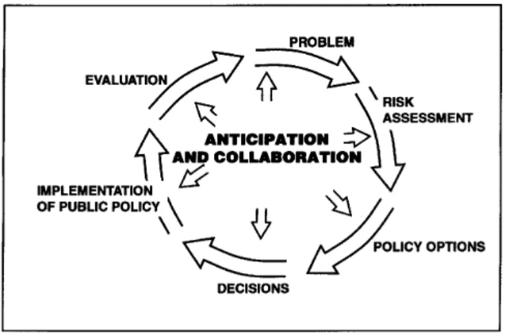
3. Hazard assessments to find answers to the questions: Where are future earthquakes likely to occur? How big, are they likely to be? How severe will ground shaking and ground failure likely be? and How often will earthquakes of various magnitudes likely occur?
4. Risk assessments to determine: What can happen? What are the odds of it happening” and "What are the likely consequences and losses when it does occur?"
5. Risk management (i.e., mitigation, preparedness, emergency response, and recovery and reconstruction measures and regulations) to reduce unacceptable risk.
6. Hazard awareness campaigns to inform all sectors of the public of the potential threat and ways to cope. 7. Education and training to increase professional capacity.
The Palestinian Authority, which had participating informally since 1994, was officially added to RELEMR following the peace treaty between Jordan and Israel and the peace talks between the Palestinian Authority and
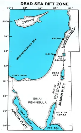
Figure 1: Map of the Arabian tectonic plate, the dominant geologic feature of the EMR. The Arabian plate is colliding with the Eurasian plate. Slip on the North Anatolian fault zone, the northern boundary,
generated the August 17, 1999 Izmit, Turkey earthquake.
Figure 2: Regional cooperation is a basic requirement to win the race with time in the EMR and WMR.
JOINT SEISMIC OBSERVING PERIOD
The seismic network operators of the EMR recognized the value of sharing the information recorded on each country’s seismic network and agreed to initiate a Joint Seismic Observing Period in 1994 to develop experience and processes on the best ways to share. The EMSC and the USGS’s National Earthquake Information Center provided technical assistance. Through this process, which ultimately was adopted as an ongoing activity of RELEMR, each country hadreliable and ready access to all the earthquake data recorded throughout the EMR. Because the Gulf ofAqaba event occurred during the second Joint Seismic Observing Period (JSOP-II) and earthquakes was greatly enhanced. In October 1997, a workshop was hosted by the Cyprus Geological Survey Department to locate this event and approximately ten of the largest aftershocks that were recorded on the EMR network. This activity marked the first time all of the seismic network operators had joined together to analyze EMR data together. The technical assistance of EMSC and LLNL greatly facilitated this endeavor which resulted in a precise location of the main shock that was impossible to attain by any seismic network operator working alone.
Figure 3: Map showing the Dead Sea transform system. Sharing network data provides all countries with access to near real-time data for the entire region.
Figure 4: Elements of a risk assessment. The input parameters include answers to the questions: Where are future earthquakes likely to occur? How big, are they likely to be? How severe will ground shaking
and ground failure likely be? and How often will earthquakes of various magnitudes likely occur?
A risk assessment provides policy makers with answers to the following kinds of questions: What are the likely consequences (i.e., losses) when an earthquake does occur? and what are the policy implications in terms of benefits and costs?
PROFESSIONAL SKILL ENHANCEMENT
training on paleoseismology for Egyptian scientists by USGS in Egypt, 5) a workshop on use of the computer to locate earthquakes convened in Nicosia, Cyprus, 6) training on emergency response for Saudi Arabian professionals in Jeddah and Yanbu, Saudi Arabia, and 7) a workshop on probabilistic ground shaking hazard maps and their applications in building codes convened in Nicosia, Cyprus.
In addition, several other activities having benefit for EMR and WMR professionals were organized. They include: 1) a workshop on seismic zonation; a policy tool for linking earthquake risk assessment with earthquake risk management [Hays, et. al, 1998] convened in Barcelona, Spain, 2) a forum on RELEMR convened in Thessoloniki, Greece in conjunction with IASPEI 97, 3) a workshop on seismic zonation of Grand Tunis, convened in Tunis, Tunisia, and 4) a program review for potential donors convened in Paris by UNESCO and USGS.
RISK ASSESMENT (MAPS) AND RISK MANAGEMENT(CODES AND LAND USE)
Since 1993, all activities of RELEMR have been focused on developing two urgently needed technical products for the benefit of the entire EMR—probabilistic ground shaking hazard maps and a modern building code having seismic design provisions based on the maps. At present, neither probabilistic grounds shaking hazard maps nor building codes having seismic design provisions are available in individual countries or the region. The occurrence of strong earthquakes along the North Anatolian fault and the Dead Sea transform fault system represents a major threat to the safety, social integrity and economic fabric for the peoples of the Middle East. Future earthquakes in the EMR are expected to impact people, property, and infrastructure without regard to political boundaries, season of the year, time of day, social status, and state-of-preparedness in the stricken country. The problem is exacerbated over time because of the increasing vulnerability of community development and the expansion of new community development into new geographic areas that are susceptible to ground shaking, ground failure, surface faulting, regional tectonic deformation, tsunamis flood wave run up, and the aftershock sequence.
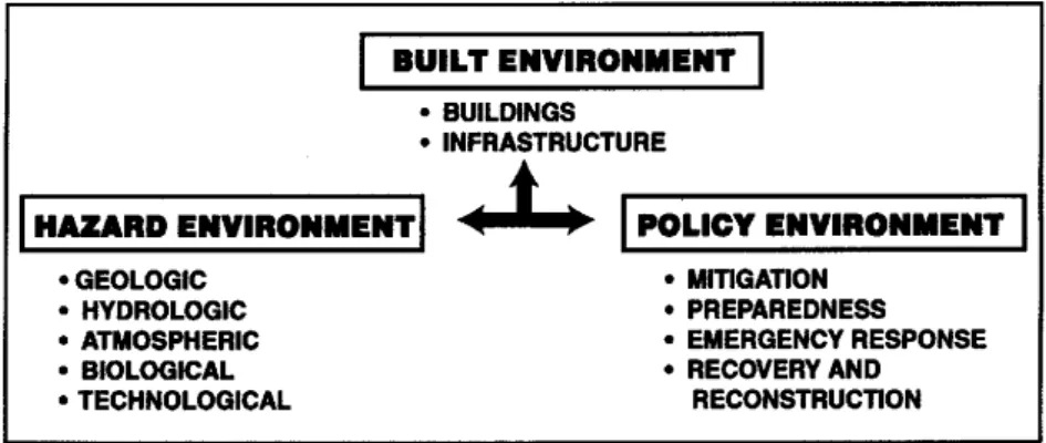
Economic losses and the numbers of deaths, injuries, homeless, jobless, and displaced peoples could be unacceptably high, as they have been in some of the historic earthquakes in past centuries. The only remedy is to reduce community vulnerability through improved public policies and professional practices planning, siting, design quality control, and construction. To reduce the existing vulnerability and the potential losses, scientists, engineers, and planners in each country must work with policy makers to integrate knowledge and experience on the hazard, built, and policy environments (Figure 5). Vulnerability reduction is urgent because the potential for the occurrence of another catastrophe, like the Izmit earthquake, affecting each EMR country is increasing with time.
Figure 5: Reduction of community vulnerability and the attainment of sustainable development calls for integrated strategies that consider all aspects of the community’s hazard, built, and policy environments.
Cooperative efforts are now underway to construct a probabilistic ground shaking hazard map of the EMR. The first step was completed in 1999. Both the EMR and the WMR contributed to the ground shaking hazard map of the world compiled by the Global Seismic Hazard Assessment Program (GSHAP). State-of-the-art earthquake hazard assessment no longer refers to single parameters such as the horizontal peak ground acceleration (PGA) as a quantifier of the hazard. The modern construction engineer requires information about the expected accelerations at frequencies similar to the natural frequencies of the building under design. In order to provide this information, we have to know (even at the most simplified level) the attenuation laws of ground motions at different frequency bands. These attenuation laws should preferably be obtained experimentally. However,
empirical attenuation functions can only be developed in regions that are well instrumented and are exposed to frequent occurrence of relatively strong earthquakes. The seismicity of the Middle East is relatively low and in great parts of the region there are no strong motion instruments. Consequently, the development of region-specific empirical attenuation functions is impractical, and alternative methods are necessary.
Cooperative projects are being planned to develop an EMR-wide building code having aseismic design provisions based on the EMR probabilistic hazard maps now being developed. The starting point will be Jordan, Israel, and the Palestinian Authority. Relevant governmental institutions in Israel and in Jordan are already in the process of preparing and/or updating their building codes. The Palestinian Authority will coordinate its regulations with those of Jordan and Israel. An EMR-wide building code does not exist and is urgently needed to stabilize the impending economic development in the region. Seismic design provisions of building code requirements are based on geological and seismological studies to quantify the spatially distributed seismic hazard parameters concerning location, maximum magnitude, frequency, and probability of occurrence. However, a building code has more than technical elements; it also encompasses social, administrative, political, legal, and economic considerations in each country. The fact is, “ Earthquakes do not kill people – buildings that are not earthquake resistant do! ” And the government has a moral imperative to protect the people by providing safe buildings.
Proper planning of community development (i.e., land use), a critically important risk management strategy, is also important for ensuring stability of future development in the EMR and is much easier to enforce if probabilistic hazard maps and aseismic building codes are available. This means that each country will soon be able to pay close attention to the ways houses, commercial buildings, schools, and hospitals to form communities and integrated with infrastructure providing the essential services of supply, disposal, transportation, and communication are sited, designed, quality controlled, and constructed.
A RACE WITH TIME
It is urgent that EMR professionals and policy makers join forces in a concerted, ongoing, collaborative to update and quantify the regional earthquake threat that all EMR peoples face. It is clear that the EMR is in a race with time. That is the reason for marshaling the region’s resources and focusing on sharing regional network data, to quantifying the seismic hazard, and preparation of probabilistic ground shaking maps and aseismic building codes.
No country in the EMR can solve the issues posed by the earthquake threat alone. The ONLY way to address the problem of earthquake hazard assessment is through genuine collaboration. By collaboration we mean: a) joint validation and verification of existing data, linkage of monitoring systems, agreeable definitions of seismological parameters, b) unification of evaluation procedures, and c) joint interpretation of the data and information. These tasks require collaboration on all working levels; from technical fieldwork, through routine data analysis to high level seismological modeling and statistical analysis. It should be emphasized that even the most elementary seismological information such as the location of an earthquake, can not be determined accurately enough by any single institution’s seismic network to justify working alone. Long-term, sustained collaboration with other institutions in the region is essential for realizing the benefits that sustainable development would provide for the EMR and the WMR.
It should be mentioned that one of the first cooperative acts after the signing of the peace treaty between Jordan and Israel was the linking of the national seismic networks. The wisdom of this action is clear; the most heavily populated areas of Jordan, Israel and the Palestinian Authority are in close proximity to the Dead Sea transform. Today, there is on-going cooperation between the seismologists, planners, and engineers of the region, either as be-lateral (e.g., Jordan - Israel), or multi-lateral agreements (e.g., through RELEMR). They are working together to find practical answers to the question, “What makes a community in the EMR vulnerable to earthquakes?” The answer is that many factors combine to make a community vulnerable to the physical effects of earthquakes. They range from the ways engineered and non-engineered buildings and infrastructure performing the essential functions of supply, disposal, transportation, and communication are combined to form the community to the
quality control, and use of individual elements of the built environment (i.e., single family dwellings, commercial buildings, schools, hospitals, government buildings, highway structures, bridges, underground pipelines, dams, power plants, airports, ports, railways).
Comprehensive studies following damaging earthquakes including the August 17, 1999 Izmit earthquake have isolated the principal factors that increase the vulnerability of a community. They include:
1. Older, non-engineered residential and commercial buildings typically constructed of un-reinforced masonry or other construction materials having little or no resistance to the lateral forces of ground shaking.
2. Older infrastructure constructed at one time to conform with a seismic code or standard that is now considered to be outdated and inadequate as a result of changes in the state-of-the art or state-of-practice. 3. Non-engineered residential and commercial buildings that are vulnerable to fire following an earthquake. 4. New buildings and /or infrastructure that have been sited, designed, and constructed without adequate
consideration of the proximity to the fault.
5. Communities sited at the water’s edge or in low-lying or coastal areas that are susceptible to tsunami flood wave run up.
6. Buildings or lifeline systems sited on or encased within poor soils that either enhance ground shaking or fail through permanent displacements (e.g. liquefaction, lateral spreading, falls, topples, slides, and flows of soil and rock).
7. Buildings having irregularities in plan and elevation and vertical and/or horizontal discontinuities in mass, strength, and stiffness.
8. Schools and hospitals—a community’s “safe haven” facilities--that have been designed and constructed with materials having low resistance to lateral forces and with irregularities in plan and elevation and vertical and horizontal discontinuities in mass, strength, and stiffness.
9. Communities having their communication facilities and disaster response control centers concentrated in the most hazardous areas instead of being widely distributed geographically to spread the risk.
10. Bridges and viaducts with high public use having outdated designs.
11. Underground utilities for electricity, gas, water, and sewage that fail due to liquefaction.
Although mitigation (e.g., building codes and land use regulations) has been recognized during the past decade as the key to becoming an earthquake resistant community, all nations throughout the world have been slow in investing in modern building codes, code enforcement, and land use regulations. The economic cost of not adopting and implementing earthquake mitigation measures and regulations has been high--on the average of $4 billion/year now in the United States, and in the order of at least $20 billion/year throughout the world. In the past decade, policy makers have learned repeatedly from each earthquake disaster that a community’s long-term investment in mitigation is the only way to prevent earthquake disasters and become earthquake resistant. Earthquake disasters (e.g., Kobe, Japan in 1995, Northridge and Loma Prieta, California in 1994 and 1989; Spitak, Armenia in 1988, Mexico in 1985, and Campania-Basilicata, Italy in 1980) have continued to produce the “expected” along with the “unexpected” (i.e., “surprises”). Because each disaster is now being used as a “laboratory,” we have significantly increased our level of understanding of earthquakes and their consequences and our capability to implement realistic, cost-effective mitigation measures and regulations. However, along with these advances, has come a sobering new awareness of the increasing vulnerability and unacceptable risk of every community’s built environment (i.e., buildings and infrastructure) over time, as understanding increases and building codes and standards for lifeline systems are improved.
Community policy makers worldwide have also learned during the past decade that they need a mix of public policies to justify investments in risk management and to optimize or balance the community’s benefit/cost. They need to invest in mitigation, while continuing to plan for the inevitable earthquake. This means that EMR policy makers in every country should consider all the mitigation options at their disposal and adopt and enforce public policies to:
1) Stop siting, designing, and constructing new buildings and lifelines systems that do not comply with current building regulations, lifeline guidelines and standards, and land –use ordinances.
2) Stop siting buildings and lifeline systems in close proximity to the causative fault,
3) Stop siting buildings and lifelines on poor soils that either enhance ground shaking or fail through permanent displacements (e.g., liquefaction, lateral spreading, and landslides),
4) Stop siting buildings and lifelines in low lying or coastal areas susceptible to tsunamis,
5) Stop designing and constructing modern buildings having irregularities and asymmetry in design and poor quality of construction,
6) Stop building any structure with inadequate earthquake resistance.
DEDICATION
This paper is dedicated to all who suffered in the August 17, 1999 Izmit earthquake disaster. We also dedicate the activities being implemented under the auspices of RELEMR by earth science organizations, network operators, urban planners, engineers, and policy makers in the EMR and WMR to them. Many colleagues are now working together in a race with time. Their goal is to: 1) promote sustainable development as a public value in every country [Tudor Rose Holdings, Ltd., 1999], 2) make the entire Mediterranean region resilient to future earthquakes, and 3) take actions that will keep earthquake disasters like that in Izmit from happening again..
REFERENCES
American Society of Civil Engineers, 1999, Civil Engineering, v. 24, no. 10.
Global Seismic Hazard Assessment Programme, 1999, A World Seismic Hazard Map, International Decade for Natural Disaster Reduction Program Forum, Geneva, July 5-9, 1999.
Hays, W., W., L. van Essche, and F. Maranzana, 1991, SEISMED and the IDNDR: Opportunities to Reduce the Risk from Earthquakes and Other Natural Hazards: in Episodes, v. 14, no. 1., pp. 13-18.
Hays, W. W., B. Mohammadious, and J. Mohammadioun, 1998, Seismic Zonation: A Framework for Linking
Earthquake Risk Assessment with Earthquake Risk Management, A monograph, Ouest Editions,
Nantes, France, 147 p. 1999.
Tudor Rose Holdings Ltd., 1999, Natural Disaster Management, England, 320 p.
United States Geological Survey, 1993, A Program to Reduce Earthquake Losses in the Eastern Mediterranean Region (RELEMR), Administrative Report, Reston, VA, 87 p.