Zurich Open Repository and Archive University of Zurich Main Library Strickhofstrasse 39 CH-8057 Zurich www.zora.uzh.ch Year: 2017
Let’s put the skyscrapers on the display—decoupling spatial learning from
working memory
Credé, Sascha ; Fabrikant, Sara I
Abstract: Driven by the increasing evidence of negative effects on spatial learning when using automated navigation systems, the academic and private sectors have become interested in strategies to improve users spatial awareness when relying on such devices during navigation. Global landmarks have been found to support orientation when using navigation devices, particularly for individuals with low spatial abilities. However, there is no empirical evidence on how global landmarks differ from local landmarks when processed and stored in working memory during navigation, and how cognitive demands from concurrent tasks might interfere with learning. In the proposed study, we aim to contribute to the understanding of these processes by investigating how local and global landmarks are mentally processed and integrated into a coherent cognitive map. We observe participants solving assisted navigation tasks with different levels of working memory load in a virtual urban environment. Insights into the efficiency of learning local and global landmarks under high concurrent task demands will be beneficial to develop future design guidelines that improve spatial learning in general, and more particularly in stressful navigation situations.
DOI: https://doi.org/10.1007/978-3-319-63946-8_31
Posted at the Zurich Open Repository and Archive, University of Zurich ZORA URL: https://doi.org/10.5167/uzh-145431
Conference or Workshop Item Accepted Version
Originally published at:
Credé, Sascha; Fabrikant, Sara I (2017). Let’s put the skyscrapers on the display—decoupling spatial learning from working memory. In: COSIT 2017: International Conference on Spatial Information Theory, L’Aquila (I), 4 September 2017 - 8 September 2017, 163-170.
decoupling spatial learning from working
memory
Sascha Cred´e , Sara Irina Fabrikant
AbstractDriven by the increasing evidence of negative effects on spatial learning when using automated navigation systems, the academic and private sectors have become interested in strategies to improve users spatial awareness when relying on such devices during navigation. Global landmarks have been found to support ori-entation when using navigation devices, particularly for individuals with low spatial abilities. However, there is no empirical evidence on how global landmarks differ from local landmarks when processed and stored in working memory during naviga-tion, and how cognitive demands from concurrent tasks might interfere with learn-ing. In the proposed study, we aim to contribute to the understanding of these pro-cesses by investigating how local and global landmarks are mentally processed and integrated into a coherent cognitive map. We observe participants solving assisted navigation tasks with different levels of working memory load in a virtual urban en-vironment. Insights into the efficiency of learning local and global landmarks under high concurrent task demands will be beneficial to develop future design guidelines that improve spatial learning in general, and more particularly in stressful navigation situations.
1 Introduction
Technological advances in mobile information technology and humancomputer in-teraction has significantly increased the multi-tasking during navigation. During as-sisted navigation users typically need to perform a variety of concurrent tasks.
Be-Sascha Cred´e
Department of Geography, Geographic Information Visualization and Analysis, University of Zurich, Switzerland e-mail: [email protected]
Sara Irina Fabrikant
Department of Geography, Geographic Information Visualization and Analysis, University of Zurich, Switzerland e-mail: [email protected]
2 Sascha Cred´e , Sara Irina Fabrikant
side reading and understanding navigation instructions of an employed system, mo-bile users also require to match this information with their perceptions of the physi-cal surroundings, while having to monitor proximal pedestrians or physiphysi-cal objects to avoid collisions, just to name a couple of relevant concurrent tasks involved in as-sisted navigation and wayfinding. Given the complexity of the parallel cognitive pro-cessing involved during assisted navigation, it can be considered as an intrinsically demanding task, and this task often imposes elevated workloads on users working memory. Importantly, prior findings indicate that under high working memory load, spatial memory performance is impaired when learning from map representations [1] and when learning from direct experiences during a navigation task [9]. Based on prior work in cognitive psychology we argue why global landmarks should be learned more efficiently, compared to local landmarks, specifically in situations of high working memory load. Building on this theoretical line of thought, we propose an ongoing empirical navigation study in a virtual urban environment that aims to investigate our contention.
1.1 Working Memory and Spatial Learning
Working memory is conceptualized as the cognitive structures responsible for main-taining, updating, and manipulating information over time [18]. It has been ap-praised as a central factor in learning about the spatial configuration of environ-mental spaces from direct experience [10]. Unfortunately, the limited resources of working memory need to be shared out dynamically between the different task de-mands. Cognitive performance in a primary task can be drastically impaired by a concurrent task which occupies attention. Prior research in psychology could show that with increasing temporal intervals between storage and recall cognitive per-formance decreased [20]. In the so called time-based resource sharing model of working memory (TBRS), researchers argue that the refreshing of information in working memory over time requires attentional resources. Any concurrent activity that occupies attention for protracted and frequent periods of time prevents the re-freshing of decaying memory [4].
We argue that temporal constraints and related spatial updating processes in working memory are also important aspects during the mental formation of large-scale spaces. Large-large-scale spaces cannot be perceived from a single viewpoint, but naturally require users to change their location and relate multiple views experi-enced during locomotion [16]. In this case, some type of temporal mental record is required, which has to maintain information over the course of several seconds or minutes. Likewise, when navigating with digital navigation assistants, temporal storage is important, because navigators need to match the represented (typically exocentric) spatial information displayed on the mobile map device with the env-iornmental information directly perceived from an egocentric perspective [13].
Given that enough processing resources are available for refreshing memories, differently acquired pieces of spatial information (e.g., vista spaces, information
ex-tracted from a map) can be integrated sequentially into a more coherent mental rep-resentation in working memory. This integrated type of spatial knowledge is often referred to as survey knowledge and mentally represents the different environmental aspects within a single reference frame. It allows users to master more complicated spatial tasks such as e.g., shortcutting, pointing or distance estimations [14]. Most likely it is survey knowledge which lacks after digital navigation system use, as contemporary navigation aids typically rely on turn-by-turn instructions, which re-inforce route perspective.
How can survey knowledge be successfully formed when attentional resources are split due to activities concurrent to spatial learning during navigation? TBRS as-sumes that activities that frequently allocate attention for refreshing memory traces should have little impact [4]. Indeed TBRS predicts that memory performance in tasks that involve both storage and processing depend on the balance between pe-riods during which memory traces decay, because attention is occupied by concur-rent processing, and those periods during which attention is available for refreshing memory traces [4].
Given negative effects of concurrent processing tasks on refreshing temporal in-formation in working memory, we aim to investigate how split attentional resources might affect the learning of local and global landmark configurations, during navi-gation in a virtual urban environment.
1.2 Global Landmarks
Landmarks are important environmental components that are used to assist navi-gation and play a critical role in spatial knowledge acquisition. Prior research in the context of mobile navigation assistance focused mostly on landmarks for the purpose of supporting the processes of route choice and local reorientation [5, 15]. Only recently, the highlighting of global landmarks on mobile map displays was recognized and investigated concerning its influence on spatial knowledge acquisi-tion [11, 12]. In their empirical study, Li and colleagues (2014) took participants to different locations in an urban district where they gained spatial knowledge using a mobile navigation device. While one experimental group had mobile devices vi-sualizing distant off-screen landmarks, the display of the control group visualized only those landmarks that fell into the mapped area. In a subsequent spatial memory task, the authors observed that individuals who reported high spatial abilities did not benefit much when learning with the visible global landmarks, compared to when only local landmarks were visible. By contrast, individuals who reported low spa-tial abilities had significant better memory when global landmarks were highlighted [12]. This evidence is especially interesting for the present study idea, because it in-dicates that global landmarks might be unequally beneficial, depending on the users cognitive processing capabilities.
4 Sascha Cred´e , Sara Irina Fabrikant
2 Empirical Study Proposal
We propose a navigation study in a virtual urban environment, in which we aim to observe the spatial knowledge acquisition performance of participants learning local and global landmarks during an assisted navigation task with different levels of working memory load requirements. Relying on evidence from prior research that found visual spatial working memory as particularly crucial for spatial updating performance during navigation [9] and for the mental representation of space in a survey manner [2], we introduce a spatial concurrent task.
2.1 Experiment Design
We developed a 2x2 mixed factorial design for 48 participants. Two groups of
par-ticipants (high|low workload) perform assisted navigation tasks in a virtual urban
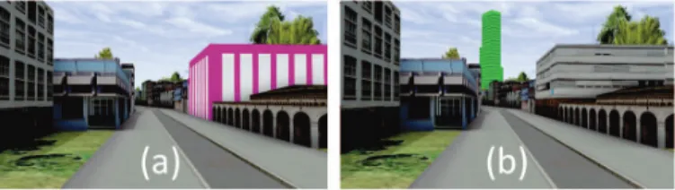
environment. Both groups are instructed to learn the configurations of landmarks which are highlighted in the environment (within-participant factor). Figure 1 shows examples of both types of highlighted local (1a) and global (1b) landmarks.
Fig. 1 Participants are asked to learn either (a) highlighted local landmarks along a route, or (b) highlighted global landmarks visible in the distance during navigation in a virtual urban environ-ment
Each trial will have four differently colored highlighted landmarks of the same type (local or global). Using a virtual reality setup, we can ensure that perused local and global landmark configurations are identical, comparable between trials, and equally distributed within trials. While the landmark type will be the within par-ticipant factor, the introduction of a concurrent task will be realized as a between subject factor. Participants in the high workload group are asked to solve a concur-rent attention-demanding task during assisted navigation. In the spatial concurconcur-rent task, participants need to indicate from which direction a sound is coming (e.g., left, right, front, or back) by pressing the a key [14]. By contrast, the control group will do the same navigation trials without the interference of a concurrent task. Still, to ensure equally timed learning periods, both groups need to solve the navigation task within an identical, moderate time constraint. Subsequent to the learning phase, we propose to test navigators spatial knowledge with a landmark-placement task [8].
Participants get a rectangular panel (30x30 cm) made out of metal and will be asked to place labeled magnets on it, representing the learned landmarks, the starting point, and the destination. Participants pick the labeled magnets one after another in a ran-dom order from an opaque bag. During the placement procedure, they are allowed to rearrange the magnet configurations until they are satisfied with their solution. The scoring of participants landmark configurations is based on their accuracy of dis-tances and angles. By metrically evaluating landmark placement, we can compare participants landmark placement to the actual placement in the virtual environment. Metric accuracy measures shall give insights into the quality of the mental represen-tations, and how well different spatial information pieces are integrated on a single, global reference frame.
2.2 Hypotheses
We expect local landmark learning to rely more heavily on working memory update, as these landmarks are not always seen at the same time. Instead, mental integration of local landmarks is restricted, due to limited visibility, and thus must be mentally processed sequentially, over the course of multiple navigation instances and views. Consequently, mental integration of local landmarks strongly relies on updating in working memory, which maintains the spatial information active until integration can take place. When concurrent processing activities occur during critical updating phases, we expect spatial learning performance to decline.
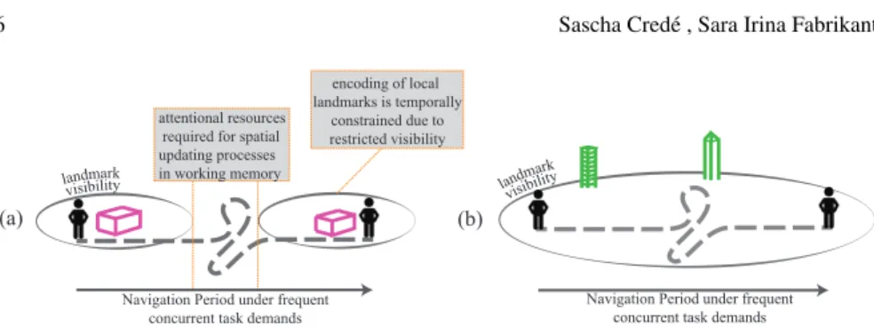
By contrast, global landmarks are often visible simultaneously, and can be seen from several parts of the route. We thus expect global landmarks to rely less on the update function of working memory to be successfully represented in spatial mem-ory. Furthermore, as global landmarks are visible from many vantage points on the route, they can also be more flexibly learned during the entire course of a navigation phase. Should attention be required by concurrent processing demands for a given period during navigation, global landmark encoding can be postponed until atten-tional resources from working memory are freed up again. Figure 2 schematizes how the concurrent task might interfere with local landmark learning, compared to global landmarks.
In summary: we hypothesize that the constant availability of attentional resources is more essential for the learning performance of local landmarks compared to learn-ing global landmarks. Consequently, high levels of mental workload (e.g., presence of concurrent tasks) have a pronounced negative impact on mentally representing local landmark configurations. By contrast, we expect spatial learning performance of global landmarks to remain unaffected by high levels of mental workload.
6 Sascha Cred´e , Sara Irina Fabrikant
(a) (b)
attentional resources required for spatial updating processes in working memory
Navigation Period under frequent concurrent task demands
encoding of local landmarks is temporally
constrained due to restricted visibility
Navigation Period under frequent concurrent task demands landmark
visibility lan
dmark visibility
Fig. 2 Attentional resources are required to different extents when learning local and global land-mark configurations. (a) In order to integrate local landland-marks in a survey representation, attentional resources are particularly required during the temporal intervals without landmark visibility. The spatiotemporal intervals between single landmark exposures require users to update the spatial relationships between their own body and relevant surroundings (b) In order to represent global landmarks in a survey representation, learning is not complicated by long spatiotemporal gaps. In case of concurrent cognitive processing demands learning can be flexibly postponed until atten-tional resources from working memory are freed up again.
3 Discussion
Prior research provides ample evidence of negative effects on pedestrian or vehicle drivers spatial knowledge acquisition when assisted by digital navigation devices during navigation and wayfinding [3, 6]. While the detrimental effects of assisted navigation is recognized and agreed upon amongst researchers from different fields [7, 17], there is little agreement on the underlying mechanisms which lead to the observed memory impairments. We propose to empirically investigate two possible sources that might explain spatial learning decline when using digital navigation assistance.
The first source concerns the particularities of mentally acquiring large scale spaces, particularly urban environment. Due to visibility restrictions the learning of urban spaces requires navigators to integrate information from different places over time. Consequently, their successful learning relies on the availability and allocation of attentional resources. However, different aspects environmental features might rely differently on the constant availability of attentional resources from working memory. Therefore, the present paper proposes to investigate to which extent local and global landmark learning is vulnerable to temporal declines in the availability of attentional resources.
The second source concerns the nature of assisted navigation, which is an intrin-sically demanding task that often happens in a multi-tasking context, and thus addi-tionally might result in conditions of high working memory loads. In this context, learning is not prioritized for the user, but users are mainly interested in getting the appropriate route directions to reach a desired destination efficiently and effectively. Following this line of thought, the resulting challenge for navigation assistance re-searchers is to find strategies how spatial learning can still be maintained with only scarce cognitive resources remaining.
We approach these two challenges by first examining whether global landmarks that play a key role in the formation of accurate mental representations require only minimal effort to be mentally processed in a high workload navigation context. The proposed experimental design investigates whether the learning of global landmarks compared to local landmarks during navigation relies less on the refreshing function of working memory. If this is so, the proper integration of global landmarks on mobile navigation displays could particularly useful to support spatial learning when users are coping with limited cognitive resources (e.g., in situations of stress).
When running the navigation experiment in a virtual urban environment we will emphasize visual information processing for spatial learning. Bodily self-movement cues (proprioceptive and vestibular information) during the learning phase and spa-tial updating processes will thus be limited [21]. This might result in small dis-advantages to the learning performance of local landmarks, compared to global landmarks. Local landmarks should benefit more from body-based sensory infor-mation, as participants effectively navigate to each landmark location. However, spatial learning is a visual process for the most part, and proprioceptive and vestibu-lar information seem to provide only very small advantages relative to visual only spatial learning [19].
Insights of the proposed empirical study will deepen our understanding of the mental processing of local and global landmarks and of the benefits of these land-marks for spatial learning in different navigation situations. Empirical results shall serve to inform future display designs for specific navigation contexts. For exam-ple, context and user responsive map designs on navigation systems could react to a users stress level during navigation in real time, and, for example, adaptively highlight global landmarks or other relevant information during navigation to fa-cilitate spatial knowledge acquisition even with heightened demands on cognitive resources.
4 Acknowledgements
This research is funded by Swiss National Science Foundation (SNF number: 156072)
References
1. Coluccia, E., Bosco, A., & Brandimonte, M. A. (2007). The role of visuo-spatial working memory in map learning: New findings from a map drawing paradigm. Psychological re-search, 71(3), 359372.
2. Aginsky, V., Harris, C., Rensink, R., & Beusmans, J. (1997). Two strategies for learning a route in a driving simulator.Journal of Environmental Psychology, 17(4), 317-331.
3. Parush, A., Ahuvia, S., & Erev, I. (2007). Degradation in spatial knowledge acquisition when using automatic navigation systems.Spatial information theory, 238-254.
8 Sascha Cred´e , Sara Irina Fabrikant
4. Barrouillet, P., & Camos, V. (2012). As time goes by: Temporal constraints in working mem-ory.Current Directions in Psychological Science, 21(6), 413419.
5. Beeharee, A. K., & Steed, A. (2006). A natural wayfinding exploiting photos in pedestrian navigation systems. InProceedings of the 8th conference on human-computer interaction with mobile devices and services(pp. 8188).
6. Burnett, G. E., & Lee, K. (2005). The effect of vehicle navigation systems on the formation of cognitive maps. InInternational conference of traffic and transport psychology.
7. Caquard, S. (2015). Cartography iii: A post-representational perspective on cogni- tive cartog-raphy.Progress in Human Geography, 39(2), 225235.
8. Frankenstein, J. (2015). Human spatial representations and spatial memory retrieval(Doctoral dissertation).
9. Garden, S., Cornoldi, C., & Logie, R. H. (2002). Visuo-spatial working memory in navigation.
Applied cognitive psychology, 16(1), 3550.
10. Hegarty, M., Montello, D. R., Richardson, A. E., Ishikawa, T., & Lovelace, K. (2006). Spatial abilities at different scales: Individual differences in aptitude-test performance and spatial-layout learning.Intelligence, 34(2), 151176.
11. Li, H., Corey, R. R., Giudice, U., & Giudice, N. A. (2016). Assessment of visual- ization inter-faces for assisting the development of multi-level cognitive maps. InInternational conference on augmented cognition(pp. 308321).
12. Li, R., Korda, A., Radtke, M., & Schwering, A. (2014). Visualising distant off- screen land-marks on mobile devices to support spatial orientation.Journal of Location Based Services, 8(3), 166178.
13. Lobben, A. K. (2007). Navigational map reading: Predicting performance and iden- tifying relative influence of map-related abilities.Annals of the association of American geographers, 97(1), 6485.
14. Meilinger, T., Knauff, M., & B¨ulthoff, H. H. (2008). Working memory in wayfinding a dual task experiment in a virtual city.Cognitive Science, 32(4), 755770.
15. Millonig, A., & Schechtner, K. (2007). Developing landmark-based pedestrian- navigation systems.IEEE Transactions on Intelligent Transportation Systems, 8(1), 4349.
16. Montello, D. R. (1993). Scale and multiple psychologies of space.Spatial information theory a theoretical basis for GIS, 312321.
17. Montello, D. R. (2009). A conceptual model of the cognitive processing of envi- ronmental distance information. InInternational conference on spatial information theory(pp. 117). 18. Repovˇs, G., & Baddeley, A. (2006). The multi-component model of working memory:
explo-rations in experimental cognitive psychology.Neuroscience, 139(1), 521.
19. Ruddle, R. A., Volkova, E., & B¨ulthoff, H. H. (2011). Walking improves your cognitive map in environments that are large-scale and large in extent.ACM Transactions on Computer-Human Interaction(TOCHI), 18(2), 10.
20. Towse, J., & Hitch, G. (1995). Is there a relationship between task demand and storage space in tests of working memory capacity?The Quarterly Journal of Experimental Psychology, 48(1), 108124.
21. Waller, D., & Greenauer, N. (2007). The role of body-based sensory information in the acqui-sition of enduring spatial representations.Psychological research, 71(3), 322332.