The Usability Analysis for the Use of
Augment-ed Reality and Visual Instructions in Navigation
Services
Anahid Basiri*, Pouria Amirian**, Adam Winstanley***
* The Nottingham Geospatial Institute, The University of Nottingham **Products and Innovation, Ordnance survey
***The Department of Computer Science, Maynooth University
Abstract. The use of Augmented Reality and visual cues as a part of navi-gational instructions, in addition to conventional audio and textual instruc-tions, may improve the experience of the users of the navigation services. This approach can be also more compatible with the way people give in-structions in everyday life; People usually associate directions with visual cues (e.g. “turn right at the square”) when giving navigational instructions in their daily conversations. In this regard, landmarks as the unique and easy-to-recognise features can play an important role. Such easy to remem-ber features, which are available both indoors and outdoors, can be helpful when exploring an unfamiliar environment. A Landmark-based navigation service can make users sure that they are on the correct route, as the user is reassured by seeing the landmark whose information/picture has just been provided as a part of navigational instruction. Such advantages of use of landmarks visual information as a part of the instructions can decrease the time of travel and improve the experiences of the users. This paper assesses how landmarks can improve the performance of pedestrian movements following landmark-based navigational instructions.
Keywords. Visual Instructions, Augmented Reality, Landmarks
1. Introduction
strat-egy works very well for machine/robot navigation, as sensors sense and measure distances and headings. However, people give navigational in-structions in a slightly different format in their daily conversations. People associate directions with visual cues, such as “turn left at the church”. Such visual cues utilise easy-to-recognise and unique features and objects.
This strategy might be more attuned to the interests of pedestrians, since they move with relatively lower speed; therefore they can notice visual landmarks easily. In addition, such unique and easy-to-recognise features help people to memorise the path they have taken and also give a better understanding of their surroundings, especially when they are exploring unfamiliar environments. Landmarks are also interesting features in their own right for many people, such as tourists.
Landmarks are available both inside and outside buildings. Therefore any navigation service that provides the users with navigational instructions based landmarks, can potentially provide seamless (indoors and outdoors) navigation solutions. Seamless navigation is one of the most challenging parts of pedestrian navigation. Seamless navigation is the topic of many research projects (Cheng et al., 2014; Zhang et al., 2012; Basiri et al., 2016; Li et al., 2013; Hansen et al., 2009). In this regard, landmarks can be used as reference points in positioning and navigation. This paper shows the ef-fect of using landmarks, as a part of positioning and navigation services, on the performance and the experiences of the users of the navigation services.
In contrast with drivers, pedestrians have a higher degree of freedom in their movements. They can walk across open areas such as squares, parks, grasslands or pedestrian malls, which can be traversed freely in any direc-tion (Gaisbauer and Frank, 2008). As current turn-by-turn navigational instructions designed to be given to vehicle’s drivers are mostly based on graph-based or street network-based algorithms, this way of navigating is not fully suitable for pedestrians as they do not only move on streets (Pielot and Boll, 2010; Amirian et al., 2015). Therefore landmarks can be used to provide seamless positioning and more desirable navigation services to pe-destrians, who, unlike drivers, can go into and through buildings to get to their destinations, who move at a relatively low speed and for whom the purpose of their travel might not only be to get to the destination, but also to explore an unfamiliar area and indulge in sightseeing along the way. Landmarks could be assets to memorise an unfamiliar environment where users visit for the first time. Also providing information on landmarks (such as name, type, colour) makes the user sure that he/she is taking the correct path and has not got lost, as the user sees the objects whose information is included in the navigational instruction.
of navigation services and spatial awareness of pedestrians. To do so, the users are provided with a photograph of to-be-seen landmarks as a part of their navigational instructions, i.e. landmark-based navigation (May et al., 2005). Landmark based navigation is a kind of navigation service in which users are provided with navigational instructions, such as turn right, go straight, turn left, etc. whenever they approach each landmarks (Fang et al., 2011). This is more compatible with human-to-human interactions and the interests of tourists and visitors (Basiri et al., 2014).
In order to implement the proposed landmark-based navigation service, the proposed service by Basiri et al. (2016) is considered and the implemented service for the campus of Maynooth University (NUIM) is assessed. In this implementation the buildings and important features, such as statues, his-toric monuments and buildings with unique architecture were stored in a spatial database as outdoor landmarks. Indoor landmarks such as main entrances and unique decorative objects and boards were also stored. For each landmark at least four photographs from different points of view but with the same distance and tilt were captured. Attributes such as names in English, names in Irish (Gaelic), age, feature category and some descriptive information were also collected and stored in the database. This database is used for both purposes of positioning and navigation.
Users can take a photograph of a registered and labelled landmark and send it to a web service provider for further process. Using image processing, feature extraction and feature matching, and thanks to the uniqueness of the landmarks, it is possible to find the landmark corresponding to the one in the database. Then using scale and rotation of the photograph taken by user (which can be measured by the landmark’s size and tilt), the relative position of the user with respect to the landmark can be calculated.
In addition to localisation, the landmarks are provided as a part of naviga-tional instructions. The instructions provided to the users contain text and pictures of the nearest landmark to be seen on the way. In showing a pic-ture of a landmark, location and heading (direction) of user movement are considered to find the most similar picture to the view of the user among available pictures (Cao and McDonald, 2012). Receiving the picture of the nearest landmark on the way, users can also enjoy a guided tour by getting information about each building while navigating.
show-ing the photographs of the landmarks can take the journey time longer. To study the impact of the visual navigation, a group of 252 students and chil-dren, 7-21 years old, were randomly assigned to two different groups. Then each was asked to follow navigational instructions for 25 minutes and find as many hidden objects as they could. The first group was provided with the textual navigational instructions, while the second group received the landmark-based navigational instructions. Once the 25 minute finished, the conductors of the experiment counted the numbers of found eggs each par-ticipant could find. The data showed that the mean number of found eggs by the participants who were provided with the image based navigational instructions is 10 eggs more than the mean number of found eggs by the participants receiving textual/traditional instruction (with the p-value of 1.3%). This improvement can enhance the field-based training activities and team projects, which require students to have a better spatial awareness of their surroundings.
The next section of the paper explains how landmarks can be used for posi-tioning and navigation purposes and the implementation of the service is shown. Then the third section evaluates the effect of landmark-based navi-gation versus traditional navinavi-gation services.
2. The Use of Visual Clues in Pedestrian Navigation
Landmarks can have an important role in navigation, in particular trian navigation services. As exploring an unfamiliar environment, pedes-trians first notice outstanding objects or structures at fixed locations. These unique objects and/or features are easy to recognise and can be kept in memory without difficulty (Schechtner, 2005) so they are essential in route navigation and locale navigation strategies. Landmarks become more rec-ognisable and therefore helpful for navigation when people move slowly, which is the case for pedestrians. The importance of landmarks for pedes-trian navigation and wayfinding instructions is proved by many studies (Michon and Denis, 2001; Denis, 2003; Lovelace et al., 1999; Raubal and Winter, 2002).
In general, landmarks have a fixed and known position, relative to which users can localise themselves. Landmarks should be carefully chosen to be easy to identify; for example, a large building has priority over a small one. A feature, which has significant contrast to the background, is a good option to be considered as landmark since its image would be easily recognisable to users. Such objects have to possess a certain saliency, which makes them remarkable and distinctive. So the surrounding area determines the charac-teristics a point must have to be perceived as a landmark (e.g. a shopping centre may not be very outstanding in urban areas, but becomes a salient landmark when being situated in a rural village).
Availability of landmarks both indoors and outdoors helps to provide the seamless positioning service to the users. The motivations behind using images of the landmarks for positioning purposes include being computa-tionally and financially cheap, and the ability to be used on readily available mobile devices almost all equipped with camera. Users can take a photo-graph of a registered landmark and then send/upload it for image pro-cessing and feature matching. The feature-matching engine can extract and identify the landmark of which the photograph has been taken. To do so, image processing, feature extraction and feature matching techniques are applied. Then scale and rotation (tilt) of the photograph is calculated, using the actual sizes of different façades of the landmark have been already stored in a database or can be measured from the images in the database. Based on scale and rotation, the vector representing relative location of the user with respect to the landmark can be calculated. Since absolute posi-tions of landmarks are available in the database, the absolute position of the user can easily be calculated and then used in path finding and navigation services (Basiri et al, 2016).
3. Evaluation
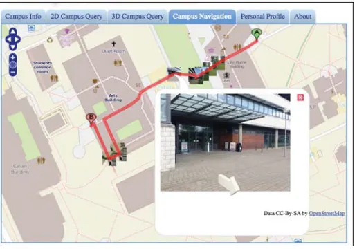
Figure 1. Visual navigational instructions in eCampus web application
In order to study the impact of providing image-based navigational instruc-tions on the movement of the users patterns and/or quality of movement, a survey is conducted and also an experiment is done.
A simple form was distributed among the users of the implemented ser-vices, i.e. staff and students of NUIM who have been registered with the e-Campus. The questionnaire, including 6 questions, asks about (a) their ex-periences with traditional navigation apps, and (b) if the use of landmarks could improve the quality of navigation services, and (c) if so how.
Based on the analysis of the comments and evaluation marks results of sur-vey shows that 82% the participants, found the landmark based navigation easier to follow in comparison with traditional navigation services, in par-ticular if they are in unfamiliar and/or architecturally complex areas, such as inside of the buildings where they have never been to. However, 32% of the participants of the survey believe that showing the photographs of the landmarks can take the journey time longer. To see if this statement is true an experiment is made to measure the number of destinations an individual can go within the fix period of time while being navigated with and without photographs of landmarks.
A group of 252 students and children, 7-21 years old, were randomly as-signed to two different groups. Then each individual was asked to follow navigational instructions for 15 minutes and find as many hidden objects as they could in 25 minutes.
”Easter Egg Hunt” finished, the conductors of the experiment counted the numbers of found eggs each participant could find. The data showed that the mean number of found eggs by the participants who were provided with the image based navigational instructions is 10 eggs more than the mean number of found eggs by the participants receiving textual/traditional in-struction.
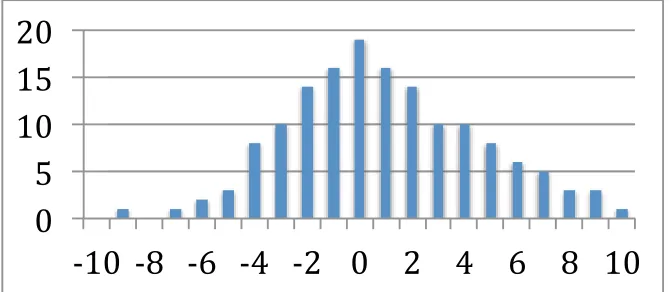
Using a simulator, the results were re-randomised into two new groups and measured the differences between the means of the new groups. This simu-lation was repeated 150 times plotted the resulting differences as given in figure 2.
Figure 2. Distribution of the difference between means of treatment and control groups
The statistical significance of the landmark-based navigational instructions is tested, see figure 2. The null hypothesis assume that the achieved results are by chance, i.e. finding 10 more objects within the same time interval is not statistically significant and has happened by chance. The alternative hypothesis to this is the statement that assumes providing landmark-based navigation service is contributing to the achieved results, i.e. the 10 more objects found by the second group is statistically significant which has not just happened all by chance.
[image:7.612.135.471.266.412.2]The possibility of finding 10 or more objects within a 25-minute test by the group receiving the landmark based navigational instructions is low enough to claim that providing the images of the landmarks as a part of the naviga-tional instructions can help the pedestrians to follow the naviganaviga-tional in-structions better. This can be applied in field based courses such as survey -ing engineer-ing, geography, geology and structure engineering, where the teaching and related activities requires better understanding of the envi-ronment. Having been tested this application within an educational centre (NUIM campus) with participation of students can bring more certitude on the practicality of it.
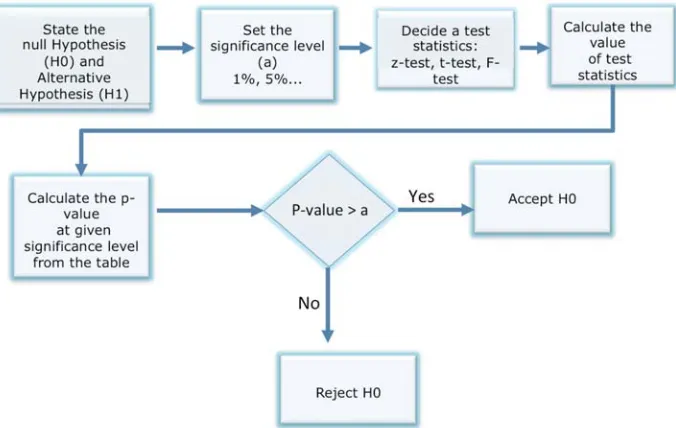
Figure 3. The process of the statistical significance test
4. Conclusion
pedestri-ans to follow the navigational instructions better; two groups of 126 partici-pants were asked to follow navigational instructions for 25 minutes and find as many hidden objects as they could, while receiving the textual and landmark based navigational instructions, respectively. The data showed that the mean number of found eggs by the participants who were provided with the image based navigational instructions is 10 objects more than the mean number of found eggs by the participants receiving textu-al/traditional instruction (with the p-value of 1.3%). This results shows that the use of photographs of landmarks as a part of navigational instructions can be a better way for pedestrian navigation who move with relatively low-er speed and thlow-erefore being more aware of their surrounding areas.
References
Amirian, P., Basiri, A., Gales, G., Winstanley, A.C. and McDonald, J. (2015). The Next Generation of Navigational Services Using OpenStreetMap Data: The Integration of Augmented Reality and Graph Databases, OpenStreetMap in GIScience, Lecture Notes in Geoinformation and Cartog-raphy 2015, pp 211-228
Basiri, A., Amirian, P, and Winstanley, A. (2014). Use of Graph Databases in Tourist Navigation Application, Computational Science and Its Applications–ICCSA 2014, pp 663-677.
Basiri, A., Amirian, P., Winstanley, A., Marsh, S., Moore, T., & Gales, G. (2016). Seamless Pedes-trian Positioning and Navigation Using Landmarks. Journal of Navigation, 69(01), 24-40. Brenner, B. and Elias, B. (2003). Extracting landmarks for car navigation systems using existing GIS databases and laser scanning. In ISPRS Archives, Vol. XXXIV, Part 3/W8, Munich, Germany. Cao, Y. and McDonald, J. (2012). Improved feature extraction and matching in urban environ-ments based on 3D viewpoint normalization. Computer Vision and Image Understanding, 116(1), 86–101.
Cheng, J, Yang, L., Li, Y. and Zhang, W. (2014). Seamless outdoor/indoor navigation with WIFI/GPS aided low cost Inertial Navigation System, Physical Communication. Available online 9 January 2014, ISSN 1874-4907.
Denis, T.M. (2003). Referring to Landmark or Street Information in Route Directions: What Difference Does It Make? In Spatial Information Theory. Lecture Notes in Computer Science, Vol. 2825, W. Kuhn, M. Worboys, S. Timpf, Eds., Heidelberg: Springer, 384-397.
Elias, B. (2003). Determination of Landmarks and Reliability Criteria for Landmarks. Technical Paper, ICA Commission on Map Generalization, 5th Workshop on Progress in Automated Map Generalization, IGN, Paris, France.
Etienne, S. and Séguinot, V. (1993). Navigation by Dead Reckoning and Local Cues. Journal of Navigation, 46, 364-370. doi:10.1017/S0373463300011802.
Fang, Z., Li, Q., Zhang, X. and Shaw, S.L. (2011). A GIS data model for landmark-based pedestrian navigation, International Journal of Geographical Information Science, DOI:10.1080/13658816.2011.615749
Hansen, R., Wind, R., Jensen, C.S. and Thomsen, B. (2009). Seamless Indoor/Outdoor Position-ing Handover for Location-Based Services in Streamsp. In Tenth International Conference on Mobile Data Management: Systems, Services and Middleware, 267-272.
Holm, S. (2009). Hybrid ultrasound-RFID indoor positioning: Combining the best of both worlds. IEEE Int. Conf. RFID, Orlando, Florida, 155-162.
Lee, J.K., Grejner-Brzezinska, D.A. and Toth, C. (2012). Network-based Collaborative Navigation in GPS-Denied Environment. Journal of Navigation, 65, 445-457. Doi: 10.1017/S03734633 12000069.
Li, X., Wang, J., and Li, T. (2013). Seamless Positioning and Navigation by Using Geo-Referenced Images and Multi- Sensor Data. Journal of Sensors, 13(7), 9047–9069.
Lovelace, K., Hegarty, M., Montello, D. (1999). Elements of Good Route Directions in Familiar and Unfamiliar Environments. In Spatial Information Theory, Proc. International Conference COSIT ’99, C. Freksa, D. M. Mark, Eds., Heidelberg: Springer, 65-82.
Lynch, K.(1960). The image of the city. MIT Press, p. 48.
May, A.J., Ross, T. and Bayer, S.H. (2005). Incorporating Landmarks in Driver Navigation System Design: An Overview of Results from the REGIONAL Project. Journal of Navigation, 58, 47-65. Doi: 10.1017/S0373463304003054.
Michon, P.E. and Denis, M. (2001). When and Why Are Visual Landmarks Used in Giving Direc-tions? In Spatial Information Theory, Proc. International Conference COSIT 2001, Heidelberg: Springer, 292-305.
Millonig, A. and Schechtner, K. (2005). Developing Landmark-based Pedestrian Navigation Sy s-tems. Proceedings of the 8th International IEEE Conference on Intelligent Transportation Sy s-tems. 0-7803-9215-9/05. pp 196-202.
Pielot, M. and Boll, S. (2010). "In Fifty Metres Turn Left":Why Turn-by-turn Instructions Fail Pedestrians. Haptic, Audio and Visual Interfaces for Maps and Location Based Services.
Raubal, M. and Winter, S. (2002). Enriching Wayfinding Instructions with Local Landmarks, in Geographic Information Science. Lecture Notes in Computer Science, 2478, M.-J. Egenhofer, D. M. Mark, Eds., Heidelberg: Springer, pp. 243-259.
Redish, D. (1999). Beyond the cognitive map: from place cells to episodic memory. Cambridge: MIT.
Schechtner, M.K. (2005). Developing Landmark-based Pedestrian Navigation Systems. Proceed-ings of the 8th International IEEE Conference on Intelligent Transportation Systems Vienna. Siegel, W. and White, S.H. (1975). The Development of Spatial Representations of Large-scale Environments. Advances in Child Development and Behaviour, 10, 9-55. H.W. Reese, Ed., New York: Academic Press.
Vepa, R. (2011). Ambulatory Position Tracking of Prosthetic Limbs Using Multiple Satellite Aided Inertial Sensors and Adaptive Mixing. Journal of Navigation, 64, 295-310. doi:10.1017/S0373463310000494.
Werner, S., Krieg-Brückner, B., Mallot, H., Schweizer, K. and Freksa, C. (1997). Spatial Cognition: The Role of Landmark, Route and Survey Knowledge in Human and Robot Navigation. In In-formatik aktuell, M. Jarke, K. Pasedach, K., Pohl, Eds., Berlin: Springer, pp. 41- 50.