Volume-6 Issue-2
International Journal of Intellectual Advancements
and Research in Engineering Computations
An Efficient path planning for Emergency Navigation
with Distributed Wireless Sensor Networks
1R.GAYATHRI, 2S.JOSIPHUS, 3V.KALAIVANI, 4K.KAVITHA
1-3 UG Students, Department of Computer Science and Engineering, Nandha Engineering College, Erode
4
Assistant Professor, Department of Computer Science and Engineering, Nandha Engineering College, Erode
Email id: [email protected],[email protected],[email protected]
Abstract
When emergencies happen, navigation services that guide people to exits keeping them away from emergencies are critical in saving lives. To achieve timely emergency navigation, early and automatic detection of potential dangers, and quick response with safe paths to exits are the core requirements, both of which rely on continuous environment monitoring and reliable data transmission. Wireless sensor networks (WSNs) are a natural choice of the infrastructure to support emergency navigation services, given their relatively easy deployment and affordable costs, and the ability of ubiquitous sensing and communication. In this project, a situation-aware emergency navigation algorithm named SEND, which takes the hazard levels of emergencies and the evacuation capabilities of exits into account and provides the mobile users the safest navigation paths accordingly is being proposed. The situation-aware emergency navigation problem is formally modelled and a hazard potential field in the network, which is theoretically free of local minima is established. By guiding users following descend gradient of the hazard potential field, SEND can thereby achieve guaranteed success of navigation and provide optimal safety. The effectiveness of SEND is validated by both experiments and extensive simulations in 2D and 3D scenarios.
Index Terms—Emergency navigation; situation-aware; sensor networks; exit capability; hazard potential field.
Introduction
The important application of such in-situ interactions is IOT based WSN-assisted emergency navigation, where the WSN infrastructure is utilized as a cyber-physical system. In this mobile environment, the internal users are equipped with PDAs or smart phones that can talk with the sensors. The emergency occurs, the IOT based WSN explores the emergent field and provides necessary guidance information to users, so that users can be guided to move out of a hazardous region through ubiquitous interactions with sensors. There are several inherent features of emergency navigation that significantly distinguish itself from packet routing schemes.
Figure 1
routing. The safety of a path not only means to be far away from a hazardous area, but also refers to mild congestion, less detour as well as fast reaction to an emergency. The human navigation consumes much more time than traditional packet routing process, due to the limited movement speed of people.
During one packet delivery process the network is often considered static, human navigation in contrast deals with emergency dynamics almost all along the guiding process. Cannot simply borrow existing packet routing schemes for emergency navigation with IOT based WSNs. The requirement of location information, and begin to consider the impact of variations of dangerous areas, which greatly enhance their applicability to more practical scenarios. Most if not all of these location-free methods seek for a global topological structure embedded in the network as the public infrastructure, through which different users can be safely guided to the exit and avoid unnecessary overhead of individually path planning.
Benefiting from recent advances in wireless sensor network (WSN) technologies, large-scale deployment of WSNs has become viable and affordable, which ever used to serve as an increasingly popular platform to engage continuous environment monitoring .
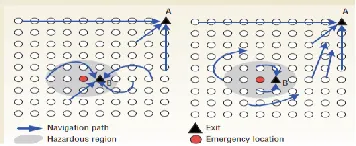
Fig 2 :Navigation scenarios in which the hazardous region is defined as two hops from the emergency site. (1) Users are directed to an exit in a hazardous region, even though another exit exists. (2) Only users already in the hazardous region are directed to exit B.
Recently there is a trend to incorporate WSNs into emergency navigation systems, aiming at providing early and automatic detection of potential dangers, such as geologic disasters, wildfire hazards and oil/gas leakages, and navigating people to safe exits while keeping them away fro m emergencies.
This work considers such a WSN-assisted emergency navigation problem by utilizing the sensor network infrastructure as a cyber-physical system. In this mobile scenario, people are equipped with communicating devices like mobile phones that can talk to the sensors. When emergencies happen and mobile users are trapped in the field, the sensor network explores the emergencies and provides necessary guidance information to the mobile users, so that the users can be eventually guided to safe exits through ubiquitous interactions with sensors.
Although many WSN-assisted emergency navigation methods have been proposed, almost all existing approaches equally regard the hazard levels of different emergencies, as shown in Fig. 1(a). As elaborated in different emergencies could occur concurrently with each corresponding to a specific hazard level. Considering a field with poisonous gas leakage, the hazard levels of emergencies are closely related to the poisonousness of the leaked gas. For instance, chlorine gas is much more fatal than carbon monoxide. Furthermore, different sizes of leakage holes lead to different amounts of gas leakage per unit time. Therefore, when planning emergency navigation paths, people should be kept farther away from chlorine compared with carbon monoxide.
A similar idea has been elaborated in the field of chemical process safety. The navigation approaches without considering different hazard levels of emergencies may fail to provide necessary protection in the navigation process. Another limitation of existing works is that the evacuation capabilities of exits are generally assumed to be equal. When there are more than one safe exit, which is very common in reality, existing methods simply guide people to the nearest one for the sake of timeliness.
in Europe are killed in the congestions near the exits, which keep off their last hope for survival. Hence, it is rather necessary to take the evacuation capabilities of exits into consideration during the emergency navigation. Therefore, we can arrive at the plain fact that a practical and efficient emergency navigation scheme should be situation-aware, which means that we should take into consideration both the hazard levels of concurrent emergencies, as shown in Fig. 1, and the evacuation capabilities of exits, as shown in Fig. 1.
Despite its importance, on the down side, we capitalize that it is not straightforward to design such a situation aware emergency navigation. It is non-trivial to directly extending existing methods which inherently aim at navigating users along the paths with equal distances to emergencies. The main challenge here is how to define the safety properly, incorporating the impacts of both different hazard levels of emergencies and different capabilities of the exits at the same time.
Let us take the road map based navigation approach (RMN for short) for instance. RMN first builds the road map by connecting the medial axis (a path with equal distance to the hazards) of the network, with a tail route connecting the exits, and then guides users along the road map with preset directions on the road segments. To incorporate the impact of different hazard levels of emergencies, the medial axis may be built as the weighted medial axis (e.g., by assigning different weights to the distances
to different hazards to reflect different hazard levels). However, it is still difficult to incorporate the impact
of different capabilities of the exits at the same time. For one thing, the evacuation capability of an exit represents the safety level instead of the hazard level, but a unified treatment is far from ready-made.
For another, it is not easy to extend the way of direction identification on the backbone, such that the direction can divert the flows to exits in accordance with their capabilities. To address the above issues, in this paper, we present SEND, a situation-aware emergency navigation algorithm, which takes the hazard levels of emergencies and the evacuation capabilities of exits into account and
provides the mobile users the safest navigation paths accordingly.
Motivated by the fact that the natural gradients of some physical quantities always follows a natural diffusion law, e.g., water always flows from the place with a higher gravity potential to that with a lower gravity potential, we thus propose to model the hazard levels of emergencies and the evacuation capabilities of exits as hazard potentials with positive and negative values, respectively. Then we establish a hazard potential field in the network, which is theoretically free of local minima. By guiding users following the descend gradient of the hazard potential field, our method can thereby achieve guaranteed success of navigation and provide optimal safety to users.
To the best of our knowledge, SEND is the first situation aware emergency navigation scheme, considering the impacts of both the hazard levels of emergencies and the evacuation capabilities of exits. It is fully distributed and does not require any location information. It is more robust to emergency dynamics since the constructed hazard potential field reflects more global properties of the underlying connectivity. Both small-scale tested experiments and extensive simulations on large-scale WSNs, in both 2D and 3D scenarios, validate the effectiveness and efficiency of SEND.
Existing Systems
Path Planning and Navigation of Robots
Traditional robot navigation relies on on-board sensors of the robots to sense the environment, and often requires the location or geometric information to minimize the navigation path length while avoiding obstacles.
Emergency Navigation with WSNs
path selection to guide users farther away from hazardous regions.
Homotopic Routing and Information-Guided Routing
Multiple navigation paths in a WSN. Homotopic routing aims to find routing paths of a specific homotopy type, to improve load balancing and routing resilience. Information-guided routing has been explored as a scalable approach for scenarios with high query frequency
Drawbacks
Existing methods need a central controller to collect information from the entire network it take high network overhead. Existing cannot directly applied to WSN-assist emergency navigation as these approaches only design one path for one specified robot. Only consider how to find a shortest/safest path for each person while ignore the number of people on the path and the path’s stretch. Some emergency, excessive people running in a narrow path may cause heavy congestion (or even stampede) and large stretch. Only work on static networks Many physical quantities follows a natural diffusion law, and therefore the natural gradients of physical phenomena are utilized to guide the routing process.
Proposed System
Mainly focus on finding the shortest/safest path for each person, while other sub-optimal (yet safe) paths are left unused throughout most of the evacuation process. This proposed system considers such a IOT based WSN-assisted emergency navigation problem by utilizing the sensor network infrastructure as a cyber-physical system. The situation-aware emergency navigation problem and establish a hazard potential field in the network, which is theoretically free of local minima. Propose to model the hazard levels of emergencies and the evacuation capabilities of exits as hazard potentials with positive and negative values, respectively. By guiding users following the descend gradient of the hazard potential field, this method can thereby achieve guaranteed success of navigation and provide optimal safety to users.
Advantages
Propose a path selection method and theoretically prove that the selected paths guarantee. Work on dynamic network scenarios.The emergency dynamics since the constructed hazard potential field reflects more global properties of the underlying connectivity.Less Congestion and less traffic.
Modules
Network Deployment
Hazard Point
Path Hazard Metric and Safest Path
Shortest Situation Aware Emergency Navigation
1. Network Deployment
We consider a field where there may be different emergency events and multiple exits with different evacuation capabilities. People inside the field are anticipated to be immediately navigated to appropriate exits while being far away from emergencies in proportion to corresponding hazard levels. Specifically, the emergency navigation paths are expected to be farther away from areas with higher hazard levels, and Personal use is permitted, observations, we thus formulate the navigation problem as a path planning problem.
Let R denote a 2D or 3D continuous open space, which represents the field of interest. Inside R, there exist n safe exits, which are located at points Pe = {pi e|i = 1,2,...,n}. Each exit is assigned a weight based on its evacuation capability. Suppose that inR, there are m emergencies occurring at points Pd = {pj d|j = 1,2,...,m}. Each emergency is also assigned with a weight based on its hazard level. We denote the set of weights of exits and emergencies by We = {wi e|i = 1,2,...,n} and Wd = {wj d|j = 1,2,...,m},respectively.
2 .Hazard Point
following, we first focus on the hazard of an arbitrary point in the field of interest, which is the basis of finding the safest navigation path. Hazard Intensity: To quantify the hazard of a location, we introduce a novel metric called hazard intensity, which is based on the observation that for an internal user, one may feel more hazardous threat when getting closer to emergencies, and would feel safer when getting closer to exits. Furthermore, the feeling should be a vector that has the ability to describe the direction of the hazardous event. Fig. 3 shows an illustration of this simple observation. It is indicated that, the emergencies with higher hazard levels have higher probability to jeopardize the users and the exits with higher evacuation capabilities yield higher probability for users to getevacuated. Inspired
by the observation, were mark that any function can be used to represent the hazardous threats, as long as it is reversely proportional to the Euclidean distance between the emergencies.
Obviously, the hazard intensity satisfies superposition principle. In other words, the hazard intensity at point p induced by multiple emergencies and exits is the sum of the responses that would have been caused by each stimuli separately.
Hazard Potential: The hazard intensity reflects only
an instant feeling of the user, which is not enough to quantify the hazard of a single point. To this end, we introduce a function called hazardous potential lΦ(p), which\ represents the total hazardous intensity one user has starting from infinity and ending at point p. We choose infinity as a common reference point to evaluate the hazard potential in different spaces. Therefore, we define the hazard potential Φ(p) of point p as follows: Φ(p) =Zp ∞ →− I (l)dl (2) The hazard potential describes the cumulative hazard intensity that the user should take when moving from p to infinity. Accordingly, the difference of hazard potential Φ(p)−Φ(q) between points p and q can well measure which point is more dangerous to the user. Specifically, a positive value of the difference of hazard potential indicates a higher chance of the user at p to be harmed than at q. Therefore, the hazard potential can be used as a tool to quantitatively measure the amount of hazard of a single point.
3. Path Hazard Metric and Safest Path
Armed with the definition of single point hazard, we are now able to define the hazard potential field in a continuous space, which plays an essential role in finding the safest paths for trapped users. A hazard potential field Φ in a continuous space R satisfies ∇Φ(p) = I(p) (3) According to Gauss’s Law, the potential field Φ satisfies Laplace’s equation [22]:
∇I(p) = ∇2Φ = 0 (4)
Note that the function satisfying Laplace’s equation is called harmonic function and has the mean value property. Mean Value Property: If B(p,r) is a ball with the center at point p and the radius of r in the open space R, then the value of Φ(p) at the center of the ball is given by the average value of Φ on the surface of the ball. In addition, Φ(p) is also equal to the average value of Φ in the interior of the ball. Accordingly, we have
Φ(p) =1 |B(p,r)|ZB(p,r) Φdδ (5) where |B(p,r)| is the volume of the ball in R and δ is the surface measure. The mean value property implies that the hazard potential of a point in R can be easily calculated with information of the points within a disk of an arbitrary radius r. This property naturally fits the well-known unit disk graph (UDG) communication model [23] in WSNs. Thus we can take advantage of the mean value property of the hazard potential field to solve the proposed safest path planning problem in a fully distributed manner, by utilizing only the information of node’s one hop neighbors.
4. Shortest Situation Aware
Emergency Navigation
i.e., C∗ = argmin C D(C) (7) Although we have this guideline to select the safest path among all possible paths, we still face several problems to implement it in discrete WSNs where many constrains are needed to be considered.
Conclusion
The 45% where the shortest path algorithm exceeds the ACO which is attributed to not yet been implemented evaporation of the pheromone, the pheromone amount in nature may to remain a few hours to several months depending on different aspects, such as ant species, soil type, causing a minor influence on the effect of evaporation in the process of finding the shortest path. Due to the long persistence of pheromone, it is difficult for the ants to “forget” a path that has a high level of pheromone but have found a way even shorter. Keep in mind that if this behavior is transferred to the computer to design a search algorithm sometimes it can converge quickly to the local optimum. The proposed system shows the results of the trial are presented. shortest situation-aware emergency navigation by considering a more general and practical problem, where emergencies of different hazard levels and exits with different evacuation capabilities may coexist. The first model the situation-aware emergency navigation problem and formally define the safety of a navigation path. The propose a fully distributed algorithm to provide users the safest navigation paths, as well as an accelerated version that can significantly boost up the speed of the navigation.
REFERENCES
[1] A. Braun, B. E. Bodmann, and S. R. Musse, “Simulating virtual crowds in emergency situations,” in Proceedings of 12th ACM VRST, 2005, pp. 244– 252.
[2] A. D. Polyanin and A. V. Manzhirov, Handbook of Mathematics for Engineers and Scientists. CRC Press, 2006.
[3] B. N. Clark, C. J. Colbourn, and D. S. Johnson, “Unit disk graphs,” Discrete Mathematics, vol. 86, no. 1, pp. 165–177, 1990.
[4] B. E. Saltzman, “Preparation and analysis of calibrated low con- centrations of sixteen toxic gases,” Analytical Chemistry, vol. 33, no. 8, pp. 1100–1112, 1961.
[5] C. Zhang, J. Luo, L. Xiang, F. Li, J. Lin, and Y. He, “Harmonic quorum systems: Data management in 2D/3D wireless sensor networks with holes,” in Proceedings of 9th IEEE SECON, 2012, pp. 1–9.
[6]C.Buragohain, D.Agrawal, and S.Suri, “Distributed navigation algorithms for sensor networks,” in Proceedings of 25th IEEE INFO- COM, 2006, pp. 1–10.
[7] D. A. Crowl and J. F. Louvar, Chemical Process Safety: Fundamentals With Applications. Pearson Education, 2001.
[8] E. Xu, Z. Ding, and S. Dasgupta, “Target tracking and mobile sensor navigation in wireless sensor networks,” IEEE Transactions on Mobile Computing, vol. 12, no. 1, pp. 177–186, 2013.
[9] J. H. Sorensen, B. L. Shumpert, and B. M. Vogt, “Planning for protective action decision making: Evacuate or shelter-in-place,” Journal of Hazardous Materials, vol. 109, no. 1, pp. 1–11, 2004.
[10] J. San-Miguel-Ayanz, J. Carlson, M. Alexander, K. Tolhurst, G. Morgan, R. Sneeuwjagt, and M. Dudley, “Current methods to assess fire danger potential,” Wildland Fire Danger Estimation and Mapping. The Role of Remote Sensing Data., pp. 21– 61, 2003.
[11] J. Wang, Z. Li, M. Li, Y. Liu, and Z. Yang, “Sensor network navigation without locations,” IEEE Transactions on Parallel and Distributed Systems, vol. 24, no. 7, pp. 1436–1446, 2013.
[12] L. N. Trefethen and D. Bau III, Numerical Linear Algebra. Siam, 1997.
Oscillation-free emergency navigation with sensor networks,” in Proceedings of 33rd IEEE RTSS, 2012, pp. 339–348.
[14] L. Wang, Y. He, W. Liu, N. Jing, J. Wang, and Y. Liu, “On oscillation-free emergency navigation via wireless sensor net- works,” IEEE Transactions on Mobile Computing, vol. 14, no. 10, pp. 2086– 2100, 2015.
[15]M.Li, Z.Yang, and Y.Liu, “Sea depth measurement with restricted floating sensors,” ACM Transactions on Embedded Computing Systems, vol. 13, no. 1, pp. 1:1–1:21, 2013.
[16] M. Z. A. Bhuiyan, G. Wang, J. Cao, and J. Wu, “Sensor placement with multiple objectives for structural health monitoring,” ACM Transactions on Sensor Networks, vol. 10, no. 4, pp. 68:1–68:45, 2014.
[17] M. Li, Y. Liu, J. Wang, and Z. Yang, “Sensor network navigation without locations,” in Proceedings of 28th IEEE INFOCOM, 2009, pp. 2419–2427.
[18]Q.Li, M.DeRosa and D.Rus, “Distributed algorithms for guiding navigation across a sensor network,” in Proceedings of 9th ACM Mobi Com, 2003, pp. 313–325.
[19] S. Lin, G. Zhou, M. Al-Hami, K. Whitehouse, Y. Wu, J. A. Stankovic, T. He, X. Wu, and H. Liu, “Toward stable network performance in wireless sensor networks: A multilevel perspective,” ACM Transactions on Sensor Networks, vol. 11, no. 3, pp. 42:1–42:26, 2015.
[20] S. Bondorf and J. B. Schmitt, “Boosting sensor network calculus by thoroughly bounding cross-traffic,” in Proceedings of 34th IEEE INFOCOM, 2015, pp. 235–243.
[21] X. Xu, X. Li, and M. Song, “Efficient aggregation scheduling in multihop wireless sensor networks with SINR constraints,” IEEE Transactions on Mobile Computing, vol. 12, no. 12, pp. 2518– 2528, 2013.
[22] Y. Liu, X. Mao, Y. He, K. Liu, W. Gong, and J. Wang, “City See: not only a wireless sensor
network,” IEEE Network, vol. 27, no. 5, pp. 42–47, 2013.