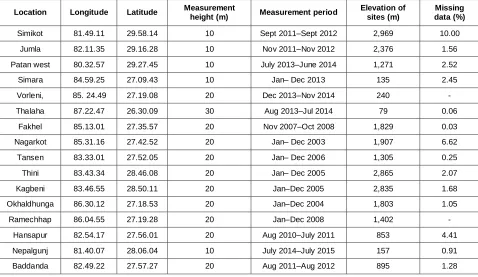
Wind Farming Feasibility Assessment In 16 Locations Of Nepal
Full text
Figure


Related documents
Similar to the 12J impact sample, the 8J impact sample does show a physical deformation on the surface of the sample and corresponds to the data obtained from
The analyses of variance of different NERICA mutant lines indicated that the difference among genotypes for all the quantitativetraits under study viz., days to flowering (1 st
This protocol replicates stored data for key k at nodes around the location to which k hashes, and ensures that one node is chosen consistently as the home node for
The results of this study were not in keeping with the findings from Park (2010), where there were not significant differences between the two groups of anxiety regarding
BPM-4 levels were also significantly positively correlated with free triiodothyronine in males ( r = 0.441, P < 0.05). 3) Multivariate analyses showed that TC was risk factor
The second way in which the resource model suggests constraints on performance is that in a particular moment of interaction drawing on one set of available resources might
The perception among healthcare staff that use of the SBAR communication tool improves communication is not unexpected, given the actual effect that use of the SBAR technique has
We suggest that the functional relationships are driven by five main conditions: (i) the type of bF relationship, (ii) the number and type of ecosystem services considered, (iii)
