www.nat-hazards-earth-syst-sci.net/15/1563/2015/ doi:10.5194/nhess-15-1563-2015
© Author(s) 2015. CC Attribution 3.0 License.
Data interoperability software solution for emergency reaction
in the Europe Union
R. Casado1, E. Rubiera2, M. Sacristan1, F. Schütte3, and R. Peters4 1Treelogic, Asturias, Spain
2Fundación CTIC, Asturias, Spain
3AntwortING Ingenieurbüro PartG, Cologne, Germany 4Veiligheids Regio Kennemerland, Haarlem, the Netherlands Correspondence to: R. Casado ([email protected])
Received: 29 July 2014 – Published in Nat. Hazards Earth Syst. Sci. Discuss.: 23 September 2014 Revised: 9 June 2015 – Accepted: 21 June 2015 – Published: 18 July 2015
Abstract. Emergency management becomes more challeng-ing in international crisis episodes because of cultural, se-mantic and linguistic differences between all stakeholders, especially first responders. Misunderstandings between first responders makes decision making slower and more dif-ficult. However, spread and development of networks and IT-based emergency management systems (EMSs) have im-proved emergency responses, which have become more coor-dinated. Despite improvements made in recent years, EMSs have not still solved problems related to cultural, semantic and linguistic differences which are the real cause of slower decision making. In addition, from a technical perspective, the consolidation of current EMSs and the different formats used to exchange information offers another problem to be solved in any solution proposed for information interoper-ability between heterogeneous EMSs in different contexts. To overcome these problems, we present a software solution based on semantic and mediation technologies. EMERGency ELements (EMERGEL) (Fundacion CTIC and AntwortING Ingenieurbüro PartG, 2013), a common and modular ontol-ogy shared by all the stakeholders, has been defined. It of-fers the best solution to gather all stakeholders’ knowledge in a unique and flexible data model, taking into account different countries’ cultural and linguistic issues. To deal with the diversity of data protocols and formats, we have designed a service-oriented architecture for data interoper-ability (named DISASTER: Data Interoperinteroper-ability Solution At STakeholders Emergency Reaction) providing a flexible extensible solution to solve the mediation issues. Web ser-vices have been adopted as specific technology to implement
this paradigm that has the most significant academic and in-dustrial visibility and attraction. Contributions of this work have been validated through the design and development of a cross-border realistic prototype scenario, actively involving both emergency managers and emergency-first responders: the Netherlands–Germany border fire.
1 Introduction
are trained, allowing them to make quick, efficient and effec-tive decisions (Muhren and Van de Walle, 2010). Enabling interoperability between different systems – both technical and cultural – allows decision makers to make sense of a sit-uation in their own terms of references and enables swifter, more effective and more efficient emergency management. DISASTER aims to enable and improve the interoperability between systems.
In order to manage and share critical information, ded-icated information and communication technology (ICT) systems, usually known either as emergency management systems (EMSs) or crisis information management systems (CIMSs), have emerged. A list of acronyms is given in Ta-ble 1.
In the member states of the EU, each stakeholder has de-ployed its own system of command, control and communi-cation. As a direct result of this situation, EMSs and infor-mation data models and formats are invariably incompati-ble with each other, meaning that cooperation between emer-gency forces becomes almost impossible in many situations (Currás, 2012). Moreover, in an international context, the sit-uation with regard to the EMS-to-EMS exchange of informa-tion provides a number of challenges, considering not only technical interoperability (data formats, models and commu-nication protocols) but also diversity in language (e.g. in Eu-rope 28 member states with more than 24 official working languages), background and cultural particularities (e.g. met-ric system), methodology or structure (diversity of organiza-tional structures starting at local level), legal issues (differ-ent regulation, complex legal landscape) or data repres(differ-enta- representa-tion (myriad colour codes, different graphical symbol sets), among others. To address these challenges a twofold solution is proposed in this article: the development of a common and modular ontology shared by all the stakeholders, taking into account different countries cultural, semantic and linguistic issues (named EMERGEL; Fundacion CTIC and Antwort-ING Ingenieurbüro PartG, 2013), and, from that point, the implementation of transparent service-oriented architecture (SOA) providing mediation algorithms compliant with cur-rent data formats and existing solutions (named DISASTER). Of course this approach is a bottom-up approach try-ing to integrate different emergency management systems, both technical and cultural. Another approach would be a top-down one by simply standardizing all emergency man-agement operations and the cooperation between agencies throughout the EU. This top-down approach has several dis-advantages. First of all there is the language barrier across most of the EU’s inner borders. Standardizing terms would mean a harmonization by translation and thus an automatic fallback to a worse translation solution than translating via a knowledge base. Second, emergency management works most effectively and efficiently if there is a certain level of standards but also flexibility to react individually on a lo-cal, regional or national level. Standard operating procedures such as the German DV 100 reflect this by offering a
frame-Table 1. Acronyms used in the paper.
Acronyms Description
API Application program interface CIMS Crisis information management COP Common operational picture DISASTER Data Interoperability At STakeholders
Emergency Reaction
DOLCE Descriptive Ontology for Linguistic and Cognitive Engineering EMERGEL EMERGency ELements EMS Emergency management system ERR Emergency response room FOAF Friend of a friend ontology GeoJSON Geographic data structure in JSON GML Geography Markup Language
ICT Information and communication technology IT Information technology
JSON JavaScript Object Notation PNG Portable Network Graphics POI Point of interest
QoS Quality of service
RDF Resource Description Framework REST Representational State Transfer
SHP Shapefile
SKOS Simple Knowledge Organization System SOA Service-oriented architecture
SPARQL Protocol and RDF Query language W3C World Wide Web Consortium WFS Web Feature Service WMS Web Map Service
WS Web services
XML Extensible Markup Language
work to work in but allow decision makers to adapt to a sit-uation. Third, the bottom-up approach is a slow but effective integration process especially in terms of acceptance of a sys-tem. By choosing a bottom-up approach the overall system can learn from practitioners and also allow them to keep their own frameworks and terms of reference. However, it also en-ables learning from each other so that a slow but effective harmonization process can take place (Groskopf, 2012).
The mentioned users take advantage of using our software interoperability solution to exchange data with other sections or other organizations within the same operation following existing models (Vickery and Vickery, 2004). The require-ments taken into account in our research were identified by interviews to stakeholders and emergency experts as well as the authors’ team member own experience and reinforced by survey results. The mentioned survey was conducted via an online tool. In total 60 experts from fire brigades, ambulance services and other related agencies completed the survey. De-tailed results on the requirement analysis can be found in Schütte and Weber (2012).
Since this work aims to create an interoperability solution for the emergency management sector, the issues connected with and to be addressed during the development need to be split into technical issues that need to be solved within the software and non-technical issues that need to be solved with the software.
The technical issues that need to be solved are the key-stone of our contribution. The main areas of interest here are format and protocol as well as data representation. Format and protocol issues, or in other words syntactical interoper-ability, are the basis of all communication between systems. This communication can take place either by standards or by message mapping to convert the data. It is necessary to iden-tify in which cases which solution is suitable. However, mes-sage mapping might be the more suitable solution for com-plex concepts that need to be transferred like units or vehicle types. Although the translated terms especially of vehicles, but also of unit types (e.g. fire engine or ambulance), suggest that the named objects are capable of doing the same tasks in an operation, this is not necessarily the case. For example the German emergency medical services know of at least three different vehicle types that can all be translated to the word “ambulance”. Vehicles and units operate as parts of a man-agement system that is in the best case a national one, but also regional management systems exist (e.g. the German fire ser-vices know 16 different laws for fire protection according to the 16 federal states). A plain translation or standardization is thus not suitable to satisfy the different complex manage-ment structures. These data need serious interpretation by the user to be understood and put into a correct context and refer-ence frame (Muhren and Van de Walle, 2010). It is important that such a reference frame is crucial for the sense-making process of the decision maker. Only such a reference frame created by training and repetition of situations and concepts allows the decision maker to decide fast.
Therefore a plain translation of terms is not suitable. Rather, these data need to be translated also in terms of un-derlying concepts. Understanding of the situation comes with a suitable representation of the transferred data. The most comprehensive form to represent relevant data in a rescue op-eration is the common opop-erational picture (COP), which can be seen as the concrete form of the framework of reference of a particular operation. The DISASTER+EMERGEL
pro-posed solution will be able to transfer the needed data to cre-ate such a situational map. In this context geo-referencing is important for the system to correctly place units and other items on the map if the map is created by the system out of different pieces of information (Köhler et al., 2006). Under-standing of a situation needs to be created by transferring the underlying concept of the data to the receiver. It is necessary to do this in a very structured way so that no information is erased or created without recognizing it. Translation tools as mentioned above can help to achieve this goal. However, it is necessary to know that most of these issues can only be solved by technical means. In contrast to the syntactic issues, this type of issues can be summarized as semantic issues.
The last aspects to mention are cultural and organizational differences between the organizations that like to exchange information. While cultural differences hinder the under-standing of the information since the concepts and the frame-work of reference are different, the organizational differences might hinder the very data exchange. Cultural differences can be solved by implementing solutions for the semantic issues mentioned above. This means the more different the (EMS) culture, the more translation work needs to be done. The fi-nal goal of the proposed solution is to create understanding of a situation by different stakeholders. Therefore the non-technical interoperability issues are of great importance.
The rest of the paper is structured as follows. Section 2 overviews the general solution composed by DISASTER and EMERGEL. Section 3 presents EMERGEL, the ontology in-novation to achieve the semantic integration of resources. Section 4 defines the DISASTER architecture and its imple-mentation details. Validation of the contributions is presented in Sect. 5 through the design and execution of a realistic pro-totype scenario actively involving both emergency managers and emergency-first responders: the Netherlands–Germany border fire. A discussion of the results is also presented in this section. Finally, Sect. 6 concludes the paper.
2 Technical solution overview
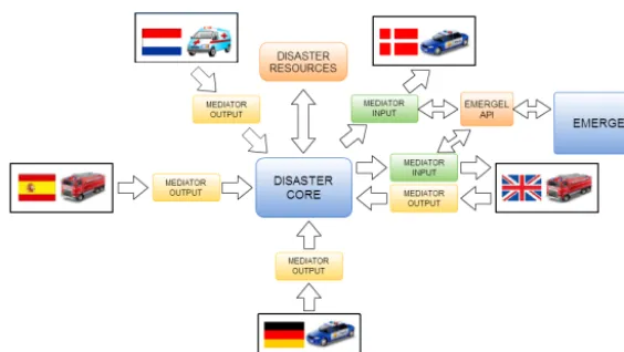
This section aims to give an integrated vision of the soft-ware solution as a whole system, its inputs and outputs and its functionality. Further details about the design and imple-mentation of the two main components EMERGEL and DIS-ASTER are presented in Sects. 3 and 4 (Fig. 1).
in-Figure 1. High-level overview of DISASTER software architecture. Each EMS is connected to its Mediator. DISASTER core provides
generic functionalities to all EMSs.
terface (API) that is consulted by DISASTER in order to ex-ecute the whole transformation process.
DISASTER architecture follows the SOA principles (Sahin and Gumusay, 2008). Using this approach, it provides the capability of using a single resource through its pub-lished service and not directly addressing the implementa-tion. This loose coupling allows changes to the implemen-tation by the service provider should not affect the service consumer. Web services (WSs) can implement SOA; they are self-contained and self-describing; and they can be pub-lished, located and dynamically invoked providing interop-erable machine-to-machine iteration over a network and an open-extensible solution (Weerawarana et al., 2005).
The DISASTER system is designed as a network of medi-ator components and a central element (core) that provides functionality to the rest of participants as shown in Fig. 1. DISASTER core is the kernel of the system and provides functionality that is shared by involved mediators, making their implementation easier and uniform. The core compo-nent is a WS where the functionality is separated into WS op-erations. Mediators are gateways between specific EMSs and resources. Each mediator relies on DISASTER-core-exposed services to perform its tasks. Mediators are also WSs provid-ing to each EMS an interface to use the whole DISASTER solution.
The EMERGEL ontology is the main source of infor-mation, well-structured to support the mediation. It mainly supports emergency situations within a common and mod-ular ontology capable of being exploited by all the stake-holders dealing with such emergency situations. The ontol-ogy has been tailored manually by consortium emergency experts and automatically published thanks to the media-tion software infrastructure. As one of the final results of this work, this ontology can be exploited by different play-ers in different forms. First, the mediation component con-sumes EMERGEL mappings to perform specific translations.
Next, the EMERGEL API adds a REST WS1layer to enable a lightweight query functionality that is already being con-sumed by the DISASTER solution.
3 The EMERGEL ontology
This section presents EMERGEL (EMERGency ELements), a new context-dependent ontology defined by experts to pro-vide semantic mediation services for emergency-related con-cepts. EMERGEL plays a main role in the software solution for data interoperability proposed in this work. It has been made publicly available at Fundacion CTIC and AntwortING Ingenieurbüro PartG (2013).
An emergency situation is a natural, man-made or techno-logical hazard resulting in an event of substantial magnitude causing significant physical damage or destruction, loss of life, drastic change to the environment or simply damage to property. From a security point of view, disasters can be seen as the consequence of inappropriately managed risks, which are the product of a combination of both hazards and vul-nerability. That kind of events stem from other events such as earthquakes, floods, catastrophic accidents, fires or explo-sions. That is why the concept of “event” is pivotal in the modelling of the ontology, as will be duly noted in the fol-lowing paragraphs.
The EMERGEL ontology development process is driven by broad-scope questions, as well as by the competency questions (González-Moriyón and Rubiera, 2012) defining the coverage of the data model to be built:
– What – the ontology interprets a disaster as a kind of event. Therefore, EMERGEL reuses the class dul:Event from the upper-level ontology DOLCE (University of Trento n.d.). Furthermore, and to specify that generic 1Representational State Transfer (REST), a software
event class, the ontology builds upon existing emer-gency incident classifications widely used in security domains, such as insurance, freight transport and criti-cal infrastructures (ports, airports etc.). These classifica-tions have been adapted and merged to fit the modelling requirements identified in a set of competency questions handed to the domain-expert partners from the DISAS-TER project to enclose the scope of the ontology. – Why – events are liable to cause other events. A
sim-ple landing operation of a plane can lead to an incident like an airplane crash in an airport. Additionally, this accident may have direct and collateral consequences such as a fire, chained explosions, a chemical accident in a neighbouring industrial facility, a full airport clo-sure etc. To semantically capture the causality chain be-tween the diverse events in a given disaster, the property emergel:causes (and a set of companion subproperties) were added to the ontology.
– Where and when – the proper spatio-temporal contex-tualization of a disaster is crucial to ensure successful information exchange among stakeholders. The ontol-ogy provides a means to temporally describe a crisis sit-uation in RDF2. This is a critical problem as informa-tion changes over time and, in particular, with respect to space. For instance, the damaged surface due to a forest fire is not the same at the beginning of the conflagration as 2 days afterwards. The EMERGEL approach is based on a 4-D (four-dimensional) view of reality, sometimes called a perdurantist perspective, and builds upon previ-ous work of tOWL (Milea et al., 2012) and 4-D Fluents ontology. With respect to spatial representation of an emergency situation, the ontology introduces a pristine ontological distinction between the involved conceptual layers: (1) features, (2) geometries and (3) feature-type classifications related to cartographic visual representa-tion (i.e. maps). This distincrepresenta-tion eases the reconciliarepresenta-tion of geographical-feature description of emergency enti-ties with pure geometrical representation of the space. The geographical information is captured by the Neo-Geo Vocabulary, which provides the distinction between features and geometries by means of spatial:feature and geom:geometry classes. The property geom:geometry is used to reconcile both facets of the same entity. – Who – many agents (with different descriptive
gran-ularity and resolution) are involved in a crisis situa-tion: from a rescue army brigade to the technical spec-ifications of a fire truck. Agents are understood in a 2Resource Description Framework (RDF) a W3C specification
that has come to be used as a general method for conceptual de-scription or modelling of information that is implemented in web resources, using a variety of syntax notations and data serialization formats.
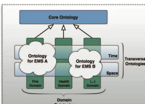
broad and generic way in order to cover beyond or-ganizations, groups of people and individual profiles. Therefore equipment, affected buildings, casualties etc. also fall into this agentive dimension of the ontology. In this sense EMERGEL reuses other vocabularies “in full force” within the Semantic Web community, such as FOAF3 and the Organization ontology (W3C n.d.). FOAF is used to model personas in an emergency situa-tion, and it is combined with another vocabulary, WAI4, based on FOAF and focusing on modelling profiles and roles. The organization ontology is a recommendation from the W3C5to model organizations, and EMERGEL reuses it for the stakeholders’ organized structures. The design of EMERGEL is divided into three main modules (Fig. 2): a core ontology, which is a supple lightweight vo-cabulary focusing exclusively on events and agents. This core module however is combined as well with a second transver-sal module dealing with time and space. Finally, the third module (vertical modules) is designed to host in the form of concept schemes any relevant vocabulary able to assist the core module.
These vertical modules enable browsing those modules by means of an ad hoc viewer (called SKOSI ´C; Fundacion CTIC, 2014) as a thesaurus for “human beings” and not only being exploited by the DISASTER API as a machine. They are thematically split into eight clearly differentiated spaces: – “Companies”: companies/enterprises potentially in-volved in an emergency situation, such as harmed par-ties (airlines, ferry lines etc.), vehicle or goods manu-facturers or as involved agents in that situation. – “Places”: places and locations in a broad sense that are
relevant in such situations – continents, geographical ar-eas, countries and their subdivisions, country associa-tions, aerial regions, airports, power staassocia-tions, bodies of water etc.
– “Vehicles”: vehicles potentially involved in incidents as victims or as agents assisting in such situations. Under this category a wide number of codes used by interna-tional organizations to identify them are included. – “Dangerous goods”: dangerous goods and substances,
including symbols and pictogram used to represent them.
– “Emergency symbols”: graphical icons, symbols and pictograms used by different countries and/or organiza-3FOAF (friend of a friend) is a machine-readable ontology
de-scribing persons, their activities and their relations to other people and objects (http://www.foaf-project.org/original-intro)
4A vocabulary to describe roles and profiles for the Semantic
Web (http://vocab.ctic.es/wai/wai.html)
5The World Wide Web Consortium, the main international
Figure 2. High-level overview of the EMERGEL components, their
transverval modules to be used in any domain and domain-specific modules (e.g. fire).
tions to represent emergency situations, agents, POIS etc. from a tactical point of view.
– “Third-party vocabularies”: standard vocabularies rele-vant for an emergency situation used by external orga-nizations. EMERGEL provides mappings between con-cepts, aligning in this way EMERGEL with these vo-cabularies.
– “Standardization organizations”: organizations that standardize products, technologies, codes etc. and that own some of the symbol sets and codes used in other theme sections of EMERGEL.
– “EMSs”: a list of emergency management systems used by diverse organizations to address this type of events.
3.1 Vertical modules development methodology The vertical modules are designed to ease the interaction be-tween domain experts and ontology engineers. To that end, emergency domains (i.e. vertical modules) were formalized collaboratively between the ontology engineers (with strong experience in OWL-based modelling) and the domain ex-perts who have collaborated in this work. The initial ap-proach was based upon a number of competency questions prepared by the ontology engineers to be addressed by the domain experts. The answers to these competency questions (González-Moriyón and Rubiera, 2012) were the cornerstone of the first steps to model the ontology. There are a number of non-ontological resources at national and European lev-els that are of EMERGEL interest. For instance, regarding crisis data representation in a given cartography, there exist different symbologies used in the European landscape. These differences pose a hindrance to interoperability in both inter-national cross-border cooperation and inter-national coordination
of stakeholders. EMERGEL aims to incorporate these in-use schemes (taxonomies, data catalogues, cartographic symbol-ogies and so forth) into a common representation format, i.e. RDF, to enable the specification of semantic equivalences to drive data translation processes between IT crisis manage-ment systems.
There are a number of options to specify these mappings between knowledge resources, ranging from heuristic-based semiautomatic generation to manual definition by experts. The former is more of a research topic that might not guar-antee accurate results. The latter is backed by the knowledge of an expert. Moreover, these manual alignments can be val-idated by the experts’ community. Given the strong domain knowledge in the project where this work has been carried out, it was reasonable to design a manual methodology to successfully involve consortium security experts in the on-tology development loop.
This methodology is a three-step workflow, defined as fol-lows: Fig. 3 shows a particular example of a translation be-tween a Dutch map symbology and a German map symbol-ogy:
1. Taxonomy creation and mapping specification – the do-main expert encodes original non-ontological resources and specifies correspondences between them in the form of a table that is specially formatted for further auto-matic processing.
2. Automatic generation of SKOS taxonomies and RDF mappings (EMERGEL vertical modules) – the tax-onomies and classifications are automatically encoded in SKOS/OWL. The previous correspondences are au-tomatically extracted from the table and converted to mappings defined in a technical format, i.e. SKOS vo-cabulary to taxonomies alignment.
3. Execution of mappings – the mappings are available on-line as part of the EMERGEL ontology. They are used on demand by the mediation component to perform a given data translation process.
In order to allow third-party applications to access the ontol-ogy, an API has been defined and called “EMERGEL API”. The EMERGEL API is available as REST services following the general DISASTER architecture approach. In addition, this API includes an SPARQL6endpoint interface to access the ontology directly. Technical documentation is detailed in Alonso et al. (2013) and González-Moriyón and Tejo-Alonso (2014). The reference implementation of EMERGEL API REST services has been developed using Play Frame-work 2.1.1. The web application that contains the services is deployed over an Apache Tomcat/7.0.26 using Java 1.6.0 24-b24.
6SPARQL Protocol and RDF Query Language, an RDF query
Figure 3. Processes involved in symbology translation applied to situational information maps for emergency responders.
Figure 4. DISASTER software technical architecture. The DISASTER core is the kernel of the proposed technical solution. It provides a set
of functionality to the mediators making their implementation easier and uniform. A DISASTER Mediator is a gateway between a concrete EMS and the rest of the existing resources. Input mediators allow an EMS to consume external resources adapted to each one’s own style. Output mediators allow sharing information to other EMS.
4 The DISASTER software architecture
This section describes the architecture of the DISASTER solution but also presents the technologies used to imple-ment the whole system. The WS platform has been chosen as a technical paradigm due to its loosely coupled, standard-based approach for building SOA solutions.
– Handlers: according to the data model used in DISAS-TER (Sect. 2.1), all data have to be transformed to the common format RDF. Once the mediation process is finished, DISASTER can provide the data in different formats. These tasks are carried out by specific services, taking into account the source and destination format. – Adapters: once the data is in RDF format, several
me-diation processes are executed to transforms data ex-pressed in a given format according to a given data scheme and available through a given protocol, into equivalent data in possibly different format, schema and protocol.
– Resources: resources in DISASTER are defined as a cat-alogue of geospatial information services compound of data about geolocated features represented primarily by images and tables or grids of observed or calculated attributes. This family of services allows publication, management and subscription of resources.
The other key component in the DISASTER architecture de-sign is the mediator. A DISASTER mediator is a gateway be-tween a concrete EMS and the rest of the existing resources. There are two kinds of mediators:
– Input mediators allow an EMS to consume external re-sources adapted to its own style.
– Output mediators allow sharing information to other EMS.
Mostly mediators are input mediators since the most com-mon problem for an EMS is to be able to understand external information. Note that both solutions are non-intrusive for the existing applications.
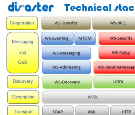
Figure 5 summarizes the set of WS specifications that DIS-ASTER will adopt in its implementation. This set of stan-dards, called the Disaster Technical stack, is not a random walk through a space of WS specifications but rather an or-ganized, structured architecture with well-defined designs to fulfil the technical requirements (Casado et al., 2012c).
The Disaster Technical stack is divided into six levels ac-cording to the nature of the included WS standards. The bot-tom level is transport, which refers to the message format and protocols used to exchange the information. Descrip-tion level includes the standards to describe both funcDescrip-tional and non-functional characteristics of the services. Discov-ery level refers to the standards used to publish and organize the services included in the DISASTER solution. Messaging level refers to the mechanism provided to ensure that mes-sages are correctly delivered to the appropriate destination. Quality of service (QoS) level focuses on the reliability and security of the interactions. Finally, Cooperation level deals with the composition and coordination between multiple ser-vice operations when required (Casado et al., 2012).
Figure 5. DISASTER technical stack. The bottom level is transport,
which refers to the message format and protocols used to exchange the information. Description level includes the standards to describe both functional and non-functional characteristics of the services. Discovery level refers to the standards used to publish and organize the services included in the DISASTER solution. Messaging level refers to the mechanism provided to ensure that messages are cor-rectly delivered. Cooperation level deals with the composition and coordination between multiple service operations when required.
As briefly introduced in Sect. 2, the DISASTER solution is a network of components (mediators) and a central com-ponent (core). The core provides a set of functionality to the mediators making their implementation easier and uniform. That functionality includes data adaptation, data mediation and resource management. In terms of implementation, the core exposes a WS interface where the functionality is split into concrete WS operations. Each mediator is a gateway be-tween a concrete EMS and the rest of the existing resources. It allows consuming information from external sources but presenting such data adapted to the concrete EMS character-istics. The mediator relies on the services provided by the core to perform the majority of its activities. In terms of im-plementation, the mediator is a WS client that interacts with the core, but also it is a WS itself providing an interface to the EMS to use the whole DISASTER solution. As depicted in Fig. 1, each EMS has to be related to mediators. There are two types of mediators according to each their behaviour:
– Input mediator: it allows consuming information from external sources while presenting such data adapted to the concrete EMS characteristics. These characteristics refer not only to technical issues (e.g. formats and proto-cols) but also to cultural and linguistic preferences and tactical values of resources. The mediator relies on the services provided by the DISASTER core to perform the majority of its activities such as data format adapta-tion or the resources management and in the EMERGEL solution to solve the semantic interoperability.
The mediator components allow the EMSs to use external information transformed to their own protocols, formats and cultural and linguistic characteristics. The main task of me-diators is to handle the EMS requests. The mediator com-ponents in charge of dealing with EMS requests are called handlers. DISASTER solution implements handlers for the most common data type and protocols such as Web Feature Service (WFS) (WFS, 2010) and Web Map Service (WMS) (WMS, 2006) requests. New handlers can be implemented whenever necessary, due to the loosely coupled nature of the solution. The handler receives the EMS request, gets the re-quested information as GML (GML, 2007) from the DIS-ASTER resources component and by using the proper EMS mediator translates the concepts. If a format or protocol adap-tation is required, the handler does the transformation using DISASTER core services and responds with the mediated in-formation. A key element in the semantic mediation is the use of the EMERGEL component that is totally transparent for the involved EMSs.
– Adapters are responsible for transforming the data for-mat and protocol. When two systems exchange informa-tion, it may be in different formats. Adapters transform the information provided by concrete EMSs into shape-file (SHP) (Environmental Systems Research Institute, 1998) format so DISASTER core services can manage it. The information provided by DISASTER core ser-vices in GML format has to be transformed in a format that the EMS can understand using the adapters. Im-plemented adapters include GML (GML, 2007), XML (XML, 2000), PNG (ISO n.d.), WMS (WMS, 2006), WFS (WFS, 2010), JSON (JSON, 2002), GeoJSON (GeoJSON, 2008) and SHP (Environmental Systems Research Institute, 1998).
– Semantic-based mediators are in charge of executing the mapping between different data schemas. In order to execute this mapping, the EMERGEL REST API is consumed. Further details about EMERGEL were pre-sented in Sect. 3.
Resources component allows EMSs to publish their opera-tional picture maps. Non-geospatial information such as me-diation issues, roles and permissions are also managed by the DISASTER resources component.
5 Validation
A scenario-based design is followed by the authors to vali-date their contributions. The test scenario is a key element in this approach, whose purpose is to verify that the DISAS-TER architecture plus the EMERGEL ontology has the po-tential for real-world application. Real EMSs such as LCMS (Landelijk Crisis Management System; LCMS, 2010), for the Dutch side, and DISMA (DISaster MAnagement; TUV Rheinland n.d.), for the German one, are used in the eval-uation. These EMSs are briefly introduced in Sect. 5.3. We selected these two concrete EMSs for practical purposes: members of the consortium in charge of executing this re-search had access to and knowledge of these two software applications. In addition, both EMSs have already been used in the Netherlands and Germany. The Netherlands–Germany border fire use case was designed and executed to provide a realistic test situation, and it is based on a proven history of needs for interoperability of EMSs. The planned scenario aims to bring together the key stakeholders, the technologies on which they depend and the middleware solutions from DISASTER+EMERGEL to demonstrate the potential for improved interoperability.
5.1 Scenario history: border fire
The information for this scenario was provided mainly by the fire department of the city of Bocholt (Germany) and col-lected during interviews with the operational command staff of the fire department of the city of Bocholt. In addition, the operational report of the Dutch operation was reviewed to create the scenario. This report is not publicly available.
The meaningful (semantic) cross-border exchange and presentation of information required to ensure safety in-cludes geographic information (GI), metadata and at-tribute data supported by a reliable middleware transla-tor/transformer.
5.2 Test objectives
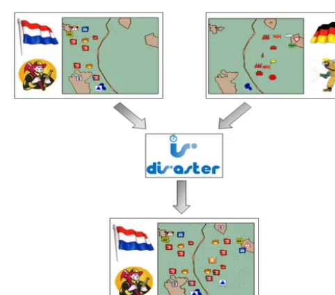
In response to the observed features of the above-referenced historical scenario, the authors conducted realistic proof-of-concept testing whereby a cross-border COP can be gener-ated as shown in Fig. 6. The figure shows that in the Nether-lands the COP is map-based, with icons showing personnel and vehicle deployment, and it stops at the Dutch border. The same is true for the German COP. The elements can be com-bined using the DISASTER+EMERGEL solution as shown in final image.
The proposed use case scenario and test event involved as-sembling a set of first responders, vehicles, ancillary equip-ment, communications etc. in a suitable location so as to al-low commanders and staff to use the interconnectivity of our innovative solution to enrich their COP. The intention is that they will command and observe movement of personnel and vehicles at different parts of the exercise field, will make con-tinuous adjustments to the situation (as per their normal ex-ercise activities) and as a consequence will see the changes from both sides of the “virtual border” propagated across to ensure a cross-border COP as illustrated previously (Erden and Co¸skun, 2010).
5.3 Test setup
The planned test event was conducted in December 2012 and located at Twente Airport near Enschede, the Nether-lands. The test was planned as part of the annual national security exercises which use this military site, and this al-lowed all of the mentioned stakeholders to be present. Vehi-cles with transponders fitted will appear on maps automati-cally since they are already tracked that way, and personnel will be placed on maps by having local team commanders report position information in the normal way via the active EMSs.
Commanders were allowed to continually make adjust-ments to personnel and vehicle position data in the EMS within the parameters of their normal exercise activities, and both they and the authors were able to continually observe activities via an enriched display, as observed from all stake-holders.
The airfield is surrounded by some woodland in that area and so is shrouded by trees. By positioning vehicles in such a way that they could not see each other, the scenario was able to show commanders in different groups/vehicles exchanging crisis management information they cannot acquire without collaboration.
Figure 6. Combining German and Dutch common operational
pic-tures (cross-border COP).
The main technical objective of our solution is the inter-operability of different software systems. To validate this re-quirements, in the test scenario two actual EMSs were used: LCMS (LCMS, 2010) (the Netherlands) and DISMA (TUV Rheinland n.d.) (Germany).
LCMS is an EMS used by 20 of the 25 public safety and security regional authorities in the Netherlands. It can be re-garded as the National EMS for the Netherlands. At opera-tional level there is a single naopera-tional communication network for police, fire brigades and the first-responder teams. LCMS viewer provides a specific interface for each emergency role and makes a link with the central database of emergency re-sponse room (ERR) systems. It also provides a reporting tool where all activities during an incident are logged.
DISMA is a software application developed for executive staff in emergency management. It is used by the silver level in large-scale incidents and provides functionalities such as plotting the incident locations, placing icons over a map, working with more than just one map at the same time etc. Unlike the Netherlands, Germany does not use homogeneous software for emergency management. DISMA is just one of the EMSs used in Germany.
In order to standardize the geospatial information gener-ated in the DISMA XML-based own format, a MediatorOut-put has been developed whose main goal is to convert the exported information into ESRI SHP format and then send the file to DISASTER core services so that this mediation can be shown through EMERGEL.
medi-ators use DISASTER core components to transform the ex-ported information provided by the different EMSs into SHP. 5.4 Test results: discussion
From a functional point of view the results showed that an improvement for decision making in an emergency situation with the support of the DISASTER solution is possible. Two aspects form the improvement from a functional perspective: 1. The fact that an interoperability solution for EMS en-ables a fast exchange of information enen-ables a quicker decision-making process. Information can be trans-ferred directly without using extra technology. In the specific case of the test the decision makers could use their own situational maps and did not have to meet and discuss since the information was available imme-diately.
2. Presenting the exchanged information in the EMS in a way the viewer or user is used to seeing (like the na-tional EMS symbol standard) quickens the process of understanding the situation and thus also leads to faster decision making. Not every piece of information needs to be explained in meetings anymore. In the specific case of the test the number of meetings was significantly reduced compared to other tests the authors had wit-nessed in the past. Decision making went smoothly and effectively, and the situation was solved quite fast. This is often not the case in such a situation. In many cases in the past the decision makers were caught in a discussion circle, sometimes about a rather irrelevant aspect of the situation.
Since time is the number-one quality parameter in emergency situations (Swersey, 1994) both aspects have direct impact on the quality of the emergency response. Given the modu-lar approach, the DISASTER core and mediator components ensure that new EMS can be added to the system easily and thus will enable a quick adoption of the solution.
However, the technical nature of the solution leads to sev-eral challenges related to information exchange that could also be observed during the test. Since the information is pre-sented in the particular viewer’s context of understanding, it is necessary that accuracy in the translation and mediation process are made known to the viewer. If the information cannot be translated directly, this leads to either a lack or an increase of information. For example, the term “fire engine” implies a basic understanding of the use of such vehicle, but also very specific differences in understanding for decision makers from different countries. Next to the technical solu-tion of making changes to the informasolu-tion obvious by adding a warning symbol and an overview of the changes, it is also important that each user of the system is able to train the use on a regular basis. These guidelines are being developed to allow future users to understand the use of the DISASTER
solution and to design effective training scenarios. Finally, with DISASTER being a technical solution, there needs to be an implementation phase before the system can be used. The test showed that this implementation phase needs to in-volve serious testing and also training of the users so that information is readily available when needed.
This was also the conclusion of a research-practitioner workshop that was organized in January 2014 in Bocholt (DE). 60 participants from fire departments from the Dutch– German border as well as several researchers discussed the details of the DISASTER solution during this workshop.
From a technical point of view, the results showed the via-bility of the proposed architecture to deal with the mediation requirements. Besides the linguistic, tactical and operational differences, some technical issues also have to be addressed. The German brigade publishes the map on a WFS server. On the other hand, the Dutch emergency system only accepts the WMS servers. As commented in Sect. 2.4, it implies different levels of mediation:
– cultural mediation: to use different icons to represent the same concept;
– protocol mediation: to allow using WMS protocol when no export mechanism is provided.
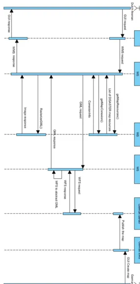
Figure 7 depicts the sequence diagram for the border fire scenario according to the DISASTER+EMERGEL archi-tecture. Firstly, the German fireman creates the map using his brigade’s own EMS system. This map is published on its WFS server. At this time, the Dutch fireman wants to get the updated information from the German side. The Dutch fireman uses his brigade’s own EMS (called LCMS as the real system) to connect to the German WFS server. But the LCMS does not work with WFS servers, so the DISASTER solution is needed. Instead of connecting directly to the Ger-man server, the LCMS connects to its mediator (called Medi-atorDutch), which is implemented as a WS. MediatorDutch consults with the DISASTER core the list of available re-sources. The German WFS server is included in the available resources, which means that the information from this server can be mediated. MediatorDutch, using the information pro-vided by the DISASTER core, contacts to the MediatorG-erman, which is in charge of the linguistic mediation from German context to the DISASTER ontology concepts. The mediation is completed following the next steps:
1. MediatorDutch requests the WFS map (GML format). 2. MediatorGerman gets the local DISMA XML data,
transforms them to GML and publishes the final infor-mation to the DISASTER resources component. 3. By using the DISASTER Core GML2RDF adapter,
4. MediatorGerman responds to MediatorDutch with the RDF.
5. MediatorDutch, by using the DISASTER core RDF2PNG adapter, generates a valid PNG according to the set of icons used by the Dutch response teams. 6. MediatorDutch generates a valid WMS response
mes-sage and returns it to the LCMS.
7. After the mediation process explained above, the Dutch fireman can see the German map in his own EMS sys-tem and according to the local context.
6 Conclusions
EMSs are able to provide support in terms of easy access to new and existing information and quick communication with personnel on site and remotely. However, it is necessary to provide the information in a way that respects the situa-tion a decision maker is in. First of all this means providing the information in a way that is compliant with the decision makers’ way of making sense of and understanding the sit-uation, for example by using his national EMS symbol set. The DISASTER solution is able to provide such support and thus contributes to the solution for the mentioned challenges. Improving the decision-making process and thus quickening the time in which effective response actions are carried out will lead to a better operation outcome and a higher quality of rescue services.
The proposed solution based on DISASTER software ar-chitecture and EMERGEL ontology aims to provide a mech-anism so that different EMSs can interoperate during the management of crisis scenarios. The solution is based on two main concepts: (i) the use of semantic technologies support-ing the goal of a shared and semantically unambiguous infor-mation basis across organizations and (ii) the SOA paradigm to allow the collaboration between systems of a different na-ture. The scope of EMERGEL include 25 EU countries as well as further vertical modules as can be consulted in Fun-dacion CTIC and AntwortING Ingenieurbüro PartG (2013).
A set of WS standards are tailored to implement the DIS-ASTER service-oriented architecture. This stack will ensure the achievement of functional (e.g. specific data formats or communication protocols) and non-functional (e.g. security and policies) requirements. The network of mediators and the central component are the means to allow DISASTER to be an extensible and scalable project. By using standard specifications, both in architecture implementation and on the data management side, the implementation will provide the desired interoperability. For example the definition of a common format such as RDF simplifies the transformations, translations and enrichment of the data regardless of the ini-tial or final format. Regarding the architecture, the use of WS standards as a communication platform will facilitate the
in-tegration of new users who will take advantage of every mod-ule implemented before. The devised software solution has been validated through the development of a proof of concept and tested by experts, showing the viability of the proposed innovation. Although the scenario implemented for validat-ing purposes only required unidirectional communication, the DISASTER software architecture can deal with bidirec-tional communication so that the stakeholders can take ac-tions in real time.
DISASTER+EMERGEL is the result of an EU Seventh Framework Program-funded research project. Future works, in collaboration with EU stakeholders, include the adaptation of these improvements in more scenarios.
Acknowledgements. The research leading to these results has received funding from the European Union Seventh Framework Program (FP7/2007-2013) under the grant agreement no. 285069, under the research project Data Interoperability Solution At Stake-holders Emergency Reaction (DISASTER). The authors thank their project colleagues for continued support and discussions surrounding the different project meetings.
Edited by: B. D. Malamud
Reviewed by: G. Bambara and two anonymous referees
References
Casado, R., Menéndez, P., Polo, L., and Groskopf, J.: D2.51 Refer-ence Architecture & Data Model Approach Overview – V1, Ver-sion 1.1, 30 pp., available at: http://disaster-fp7.eu/sites/default/ files/D2.51.pdf, last access: 29 July 2014, 2012a.
Casado, R., Tuya, J., and Younas, M.: Testing the reliability of web services transactions in cooperative applications, in: Proceedings of the 27th Annual ACM Symposium on Applied Computing, Trento, Italy, ACM, doi:10.1145/2245276.2245418, 2012b. Currás, L.: D5.10 EMS analysis & target selection: data models
and data formats used, available at: http://disaster-fp7.eu/sites/ default/files/D5.100.pdf, last access: 29 July 2014, 2012 Environmental Systems Research Institute, Inc. (ESRI) LB –
shape-file: ESRI Shapefile Technical Description, available at: http: //www.esri.com/library/whitepapers/pdfs/shapefile.pdf, last ac-cess: 29 July 2014, 1998.
Erden, T. and Co¸skun, M. Z.: Multi-criteria site selection for fire services: the interaction with analytic hierarchy process and ge-ographic information systems, Nat. Hazards Earth Syst. Sci., 10, 2127–2134, doi:10.5194/nhess-10-2127-2010, 2010.
Fundacion CTIC: SKOSI ´C, an Open Source SKOS Viewer, avail-able at: http://bitbucket.org/fundacionctic/skosic (last access: 29 July 2014), 2014.
Fundacion CTIC and AntwortING Ingenieurbüro Part G: Emer-gency Elements Ontology (EMERGEL), available at: www.purl. org/EMERGEL, last access: 29 July 2014, 2013.
GML: Geography Markup Language, available at: http://www. opengeospatial.org/standards/gml, last access: 29 July 2014, 2007.
González-Moriyón, G. and Rubiera, E.: D2.40 Technical implica-tions compilation report, Version 0.5, 28 pp., available at: http:// disaster-fp7.eu/sites/default/files/D2.40.pdf, last access: 29 July 2015, 2012.
González-Moriyón, G. and Tejo-Alonso, C.: D4.41 Data Mediation Component V1,available at: http://disaster-fp7.eu/sites/default/ files/D4.41.pdf (last access: 29 July 2014), 2014.
Groskopf, J.: D2.32 Overview of cultural similarities, relevant dif-ferences and demands, available at: http://disaster-fp7.eu/sites/ default/files/D232_DISASTER_V1.4_2012-10-28_final.pdf, last access: 29 July 2015, 2012.
ISO, ISO/IEC: 15948:2004 – Information Technology – Com-puter Graphics and Image Processing – Portable Network Graphics (PNG): Functional Specification, available at: http://www.iso.org/iso/iso_catalogue/catalogue_tc/catalogue_ detail.htm?csnumber=29581, last access: 28 May 2014. JSON: JavaScript Object Notation, available at: http://www.
ecma-international.org/publications/standards/Ecma-262.htm, last access: 29 July 2014, 2002.
Köhler, P., Müller, M., Sanders, M., and Wächter, J.: Data manage-ment and GIS in the Center for Disaster Managemanage-ment and Risk Reduction Technology (CEDIM): from integrated spatial data to the mapping of risk, Nat. Hazards Earth Syst. Sci., 6, 621–628, doi:10.5194/nhess-6-621-2006, 2006.
LCMS: Landelijk Crisis Management Systeem, available at: http: //www.lcms1.nl/, last access: 29 July 2014, 2010.
Milea, V., Frasincar, F., and Kaymak, U.: tOWL: a temporal Web Ontology Language. IEEE transactions on systems, man, and cybernetics. Part B, Cybernetics?: a publication of the IEEE Systems, Man, and Cybernetics Society, 42, 268–281, avail-able at: http://ieeexplore.ieee.org/articleDetails.jsp?arnumber= 6003798, last access: 8 April 2015, 2012.
Muhren, W. J. and Van de Walle, B.: A call for sensemaking sup-port systems in crisis management, in: Interactive Collaborative Information Systems, Volume 281 of Studies in Computational Intelligence, edited by: Babuška, R. and Groen, F. C. A., Studies in Computational Intelligence 281, Springer, Berlin, Heidelberg, 425–452, doi:10.1007/978-3-642-11688-9, 2010.
Sahin, K. and Gumusay, M. U.: Service Oriented Architecture (SOA) Based Web Services For Geographic Information Sys-tems, The International Archives of the Photogrammetry, Re-mote Sens. Spat. Inf. Sci., XXXVII, 625–630, 2008.
Schütte, F. and Weber, B.: D2.10. End-User Requirement Re-port, available at: http://disaster-fp7.eu/sites/default/files/D2.10. pdf, last access: 29 July 2015, 2012.
Swersey, A.: Operations Research and The Public Sector, Elsevier, 1994.
Tejo-Alonso, C., Polo, L., and Casado, R.: D4.30 Data Mediation Techniques V2, available at: http://disaster-fp7.eu/sites/default/ files/D4.30.pdf, last access: 29 July 2014, 2013.
TUV Rheinland, DISMA –Disaster Management, available at: http://www.tuv.com/en/corporate/business_customers/plants_ machinery_1/industrial_plants_2/disma_disaster_management_ cw/disma_disaster_management.html, last access: 5 July 2013. University of Trento, DOLCE: Descriptive Ontology for Linguistic
and Cognitive Engineering, available at: http://www.loa.istc.cnr. it/old/DOLCE.html, last access: 8 April 2015.
Vickery, A. and Vickery, B. C.: Information Science in Theory and Practice, in: Gale virtual reference library, De Gruyter, 141 pp., available at: http://books.google.com/books?hl=es&lr= &id=TlDkvfxRedcC&pgis=1, last access: 29 July 2014, 2004. W3C, The Organization Ontology, available at: http://www.w3.org/
TR/vocab-org/, last access: 8 April 2015.
Weerawarana, S., Curbera, F., Leymann, F., Storey, T., and Fergu-son, D. F.: Web Services Platform Architecture: Soap, Wsdl, Ws-Policy, Ws-Addressing, Ws-Bpel, Ws-Reliable Messaging and More, Prentice Hall PTR, Upper Saddle River, NJ, USA, 2005. WFS: Web Feature Service, available at: http://www.
opengeospatial.org/standards/wfs, last access: 29 July 2014, 2010.
WMS: Web Map Service, available at: http://www.opengeospatial. org/standards/wms, last access: 29 July 2014, 2006.