1962 The Open Cybernetics & Systemics Journal, 2015, 9, 1962-1967
1874-110X/15 2015 Bentham Open
Open Access
Construction of Regional Pattern for Ecological Security in Regional
Development
Yang Yang
1, Liu Hao
2, Gu Chunguang*
1and Li Nan
31College of Technology Management, UCAS, Beijing 100049, P.R. China 2Department of Sociology, Peking University, Beijing 100871, P.R. China 3National Science Library, CAS, Beijing 100190, P.R. China
Abstract: The newly proposed concept, the Regional Pattern for Ecological Security (RPES), provided an integrated strategy for implementing ecosystem restoration and biodiversity conservation at regional scale. Based on the concept and its theoretical basis, the designing principles and a preliminary method were put forward. With the method, the Regional Pattern for Ecological Security of the area along the Yangtze River in Anhui Province (the AYRAP) is constructed. In terms of the ecological features of the AYRAP, an ecological security pattern should be established, consisting of 3 eco-logical sources, 6 ecoeco-logical corridors and numerous ecoeco-logical patches and wedges.
Keywords: Distortion regional pattern for ecological security, ecological feature, ecological source, the ecological service im-portance.
1. INTRODUCTION
The development of human society is extremely fast in 20th century. First, the basic necessities like foods, transport, are changed to the fantasy before. Second, there are changes in the scope of social production and human activities. The dangerous and risky work is replaced by machines. Lots of industries and jobs are created with the development of tech-nology. Third, the changing morphological objective world, the accelerating urbanization, the increasing city land occu-pied, the expansion of infrastructure, the dropping forest, the serious artificial river system, so many problems shows that landscape form of the global ecosystem changes and envi-ronmental problems expand from regions to the whole world [1-2].
The serious environmental problems in the world are a threat to the sustainable development of human society. Pro-tecting the ecological security has become the pressing social need [3]. Ecological security (eco logical security) refers to the safety of natural and semi-natural ecosystems in the nar-row sense, which reflect the integrity and health of the whole ecosystem. Broadly it refers to aspects of human life, health, happiness, fundamental rights, livelihood security sources, the necessary resources, social order and the human ability to adapt to changing environment, such can be under non-threatening condition, including natural ecological security, economic and ecological security and social ecological secu-rity, forming a composite artificial ecological security system. Generally, the ecological security [4] refers to the health status of ecological systems and other environment people
concerned about like climate, water, air, soil and so on in country or regional scale. It is the threshold of exploitation of natural resources. Ecosystem management is currently more focused on the restoration mechanisms of degraded ecosystems and discussion related to ecological economics, policy and social issues. There is still a problem that how to adjust recovery measures and management strategies on the space area, so regional ecology environmental issues can be solved more targeted. For characteristics of regional envi-ronmental problems and interference sources, reasonable construction of regional ecological patterns to implement management measures and against ecological risk, is the new requirement of regional ecological environment protection, and also is the key to the success of ecosystem management.
So, the concept of “the regional pattern for ecological se-curity” is proposed.
2. RPES CONSTRUCTION METHOD
“The regional pattern for ecological security” is defined the regional spatial patterns which can protect and restore biodiversity [5-6], maintain the integrity of the ecosystem structure and processes, achieve effective control and con-tinuous improvement of the regional ecological environment on the basis of excluded interference, for regional environ-mental problems. The proposing of regional ecological secu-rity pattern provides a new way for adaptive ecosystem man-agement. The regional pattern for ecological security pays attention to regional-scale environmental problems, relation-ship of patterns and processes, rating scale issues, impact of interference, biodiversity conservation [7], ecosystem resto-ration, socio-economic development [8], and the comprehen-sive integration of these aspects. So the theoretical founda-tion involved content from multiple subjects like Landscape
ecology, disturbance ecology, conservation biology, restora-tion ecology, ecological economics, ecological ethics, and ecological systems theory. The results of these subjects pro-vide useful reference for the regional pattern for ecological security study.
The RPES study directly pointed to the ecological prob-lems and focused on the ecological restoration and biological conservation at regional scale, the study was systematic, and the app roach was active. It emphasized on the restoration and configuration of degraded eco systems, the maintenance of eco system health, the optimization of landscape pattern, and the spatial pattern adjustment adapted to the develop-ments of the society and economics at regional scale. The spatial pattern visualized the strategies of eco system man-agement, and ensured the security of ecological pattern and process as w ell as their integration at regional scale.
A region’s ecological security pattern is the basis and guarantee of its sustainable development. For complex re-gional environmental problems, design rere-gional spatial pat-tern, to protect restore biodiversity, and maintain the integ-rity of the ecosystem structure process, achieving effective control and continuous improvement of the regional ecologi-cal environment on the basis of excluded interference in the planning stage. Through adjusting the relationship between human and human, human and nature, format the balance of consumer demand, commodity production, resources con-sumption, environmental impact, and social order [9].
Consulting the methods and experiences of other related design, like Landscape eco-planning, Security patterns, Spa-tial explicit landscape ecological model, Public participation, Scenarios, the regional pattern for ecological security design method with 5 steps is proposed.
2.1. Landscape Pattern and Functional Assessment Landscape indices are commonly used to characterize landscape pattern characteristics, which are the general quan-titative indicators react landscape components, spatial com-position, including three levels: individual plaques, plaque type and overall landscape [10]. There are some common landscape indices like landscape richness index, landscape diversity index, landscape dominance index, landscape evenness index, landscape shape index, contagion index, and separation index [11].
2.1.1. Landscape Richness Index R = n
n is the number of plaque type in landscape.
To compare between different types of landscape, rela-tive richness and richness density are used.
Rr= n
nmax (1)
Rd= n
A (2)
Rr is relative richness, and Rd is richness density.
nmax is the maximum of plaque type in landscape.
A is the area of the landscape.
2.1.2. Landscape Diversity Index
Common landscape diversity index includes 2 forms: 1. Shannon-Weaver diversity index
L= Piln
( )
Pi i=1m
(3)Pi is the probability of plaque type i in the landscope.
m is the number of plaque type in the landscope. 2. Simpson diversity index
L'=1 P i 2 i=1 m
(4)The diversity index is decided by plaque richness and uniformity of each plaque type on the area distribution. The
L is higher; the composition of landscape is more compli-cated.
2.1.3. Landscape Dominance Index
It means the role of different types of patches in the land-scape.
D=Lmax+ Piln
( )
Pii=1 m
(5)Lmax is the maximum of landscape diversity index. Pi is the probability of plaque type i in the landscope.
m is the number of plaque type in the landscope.
The higher D means the more important patches in the landscape.
2.1.4. Landscape Evenness Index
t means distribution Degree of different patches of land-scape in area. E= L Lmax = Piln
( )
Pi i=1 m ln( )
n (6)L is Shannon-Weaver diversity index, Lmax is the maximum
of it
2.1.5. Landscape Shape Index
t means the shape complexity degree of the overall land-scape (all patches).
LSI=0.25E
A (7)
E is the total length of all the patches in the landscape.
A is the area of the landscape.
2.1.6. Contagion Index
t means the aggregation degree of different types plaques.
F=Fmax+ Pijln
( )
Pij j=1 n i=1 n (8)Fmax is the maximum of contagion index 2ln n
( )
n is the number of plaque type in the landscope
Pi is the probability of plaque type
adjecent to plaque typej in the landscope
F' is used to compare different landscape.
F= F Fmax =1+ Pijln
( )
Pij j=1 n i=1 n 2ln n( )
(9)2.2. Ecological Problems Analysis
Under the presence of certain environmental problems in the region, by analyzing the regional landscape pattern, func-tion, and Associated ecosystems, get the information like the scope strength causes, processes of the ecological problems, so can propose measures to solve these problems.
2.3. Evaluation of Ecosystem
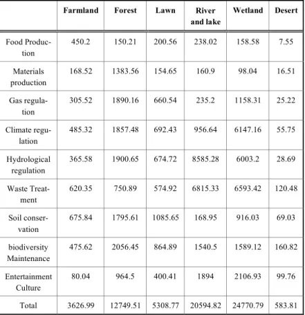
Through the study of ecological service function theory, Shegaodi used CVM investigation assessment methods; ad-justed the value of ecosystem services, established the eco-logical service value of each type land in the units area, as the Table 1 shows.
The ecological Service value of each type land calculates as this:
Vi=PiAi (10)
Vi is the ecological service value of each type land.
Pi is the ecological service value coefficient of each type
land in the units area.
Ai is the area of each type land.
The value of ecosystem services in different types land-scape is calculated.
2.4. Ecological Services Analysis
Using quantitative methods in ecological research, Evaluate services function and health of ecosystem;
Identify the main problems of ecosystem function, Evaluate the state of biodiversity; to recognize the relation-ship between ecosystem conditions and Regional environ-mental problems.
2.5. RPES Design
Based on the pattern and process principles and the over-all planning goals, regional ecological security pattern with ability to optimize constantly is created.
The regional ecological security pattern concerned about ecological security issues in this region, under the analysis with the basis of the above stages, guided by the principle of natural and heterogeneous, propose the scheme which can Table 1. The ecological service value of each type land in the units area.
Farmland Forest Lawn River and lake Wetland Desert Food Produc-tion 450.2 150.21 200.56 238.02 158.58 7.55 Materials production 168.52 1383.56 154.65 160.9 98.04 16.51 Gas regula-tion 305.52 1890.16 660.54 235.2 1158.31 25.22 Climate regu-lation 485.32 1857.48 692.43 956.64 6147.16 55.75 Hydrological regulation 365.58 1900.65 674.72 8585.28 6003.2 28.69 Waste Treat-ment 620.35 750.89 574.92 6815.33 6593.42 120.48 Soil conser-vation 675.84 1795.61 1085.65 168.95 916.03 69.03 biodiversity Maintenance 475.62 2056.45 864.89 1540.5 1589.12 160.82 Entertainment Culture 80.04 964.5 400.41 1894 2106.93 99.76 Total 3626.99 12749.51 5308.77 20594.82 24770.79 583.81
achieve different levels of ecological safety.
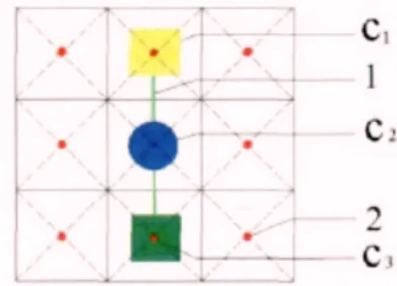
To implement the landscape function network in space,
Cost distance Model is adopted (Fig. 1).
In the migration of species, different landscape elements or land use produce a certain resistance. The work to over-come this resistance, is Accumulative cost distance.
A=1 2
(
ci+ci+1)
i=1 n (11) A= 2 2(
ci+ci+1)
i=1 n (12)Accumulative cost distance of every landscape unit in the space to the nearest ecological sources is calculated:
means the Resistance of pixel I, means the Resistance of pixel i+1, is the number of pixels,
means the distance of every landscape unit to the nearest ecological sources.
When the pixel moves in the vertical or horizontal direc-tion, (11) is adopted. When it moves diagonally, (12) is used to calculate.
According to the method in Accumulative cost distance model, using the GRID function of ArcGIS to calculate cy-clically, accumulative cost distance of every landscape unit counts out, and spatial distribution of landscape function network is designed.
3. RPES CONSTRUCTION IN THE AYRAP
A region’s ecological security pattern is the basis and
guarantee of its sustainable development. In its establish-ment, we need to play an active role in controlling detrimen-tal disturbance and exercising profitable disturbance, thus achieving coordination of the ecosystem and the socioeco-nomic system. In the rapidly developing regions, vigorous human activities bring great pressure to the ecosystem, and we need a harmonious ecological pattern, which can protect the stability of regional ecosystem and guarantee the regional sustainable development by horizontal linkage of the eco-logical space and the urban space.
3.1. Outline of the AYRAP
Take the area along the Yangtze River in Anhui Province (the AYRAP) as an example.
This area is in the transition zone between subtropical and warm temperate, with high ecosystem diversity, and good nature environment. The areas altitude above 200m account for 22.2% of the total land area, wood area account-ing for 31%, water and wetlands accountaccount-ing for 7.8%.
3.1.1. Ecological Problems in the AYRAP
1. With the rapid economic development, natural ecosys-tems in this region develop to artificial ecosystem and semi- artificial ecosystem. Species diversity and other ecosystem services is declining. Distribution of forest ecosystems with high biodiversity is not balanced, focus on the south of this region and low mountains in the west. Only 11 counties con-tain forest cover more than 30%
2. Plain in this region is artificial ecosystem based on ag-riculture and towns. Between the mountains and hills and plains along the river, urban development and Ecological space distribute as Parallel strip, lack of corridors and green buffer zone
3.1.2. The Importance of Ecosystem Services
Ecosystem services is the condition and function benifit to human survival and development in ecosystems and eco-logical processes. According to the abiliy, value, and effect of the ecosystem services, it is sort of different levels to proviod the key to protect ecological security patterns.
According to Table 2, there levels of distributions are
di-vided, very important, important, generally important. And different levels of distributions are maked by three colors,
Fig. (1). The function of cost distance model.
Table 2. The eco-service value of different land use type in the AYRAP.
Land use type Area/km2 eco-service value /104CNY*a-1
Building land 19453.1 0
River and lake 8549.5 18015.064
Forest 5843.2 7379.3773 Garden 1154.8 1458.3972 Farmland 24876.4 8826.1467
shown in Fig. (2).
The very important distributions are most in the southern and western AYRAP, the mainstream of the Yangtze River and the wetland around Chao Lake.
3.1.3. Economic Development Potentialities Analysis
Economic and Social Development of area along the riv-ers, is one of the goals in ecological security pattern co Ac-cording to landscape richness index, landscape dominance index, and difference in space, Three Ecological source re-gions are gotten, with area of 22 000km2, accounting for 35% of the whole region.
nstruction. The economic development potentiality is measured from there aspects, integrated development costs, development effectiveness and economic resources.
Fig. (3) show that the distributions with high economic
development potentialities are Hefei urban, Maanshan urban, Wuhu urban, Tongling urban, Anqing urban. The west and sourth of this region are lower.
3.2. Ecological Source Analysis
Through an analysis of eco sensitivity and ecological service importance, this article finds that the areas that need special ecological protection are the mountainous areas in the southern and western AYRAP, the mainstream of the Yangtze River and the wetland around Chao Lake.
Hilly ecological source region in the south, with area of 13475km2, is the biggest ecological source region in this region. Some rivers as Qiupu River, Qingge River, Zhang River originates from this region. So it is important to pro-tect this region to prevent from Soil Erosion Geological dis-asters and the loss of biodiversity.
Hilly ecological source region in the west, with area of 5705km2, catching six reservoirs, provide ecological serv-ices for the western region along the river.
Lake Hill Ecological source region in the middle, major with Chao Lake, connect with hilly ecological source region in the south by Yangtze River, protect a large area develop-ment.
3.3. Ecological Corridors Analysis
With the Construction of seven ecological corridor fo-cuses on the sides of major rivers, roads, the main ecological source region, important ecological plaque and the industry along the rivers are connected. These corridors, about
50-100m in width, horizontally link the ecological sources and patches and the areas of intensive development of urban in-dustries, forming a stabilized pattern of the ecological space and the urban space.
1. Yangtze River Corridor: the most important Ecologi-cal Corridor, connecting 3 EcologiEcologi-cal source regions with other 6 Ecological Corridors. It provide the Eco-logical Services of Water security, biodiversity. 2. Shuiyang River Corridor: connecting the Hilly
eco-logical source region in the south with Maanshan re-gion.
Fig. (2). The distribution of the ecological service importance in the AYRAP.
3. Qingye River Corridor: connecting the Hilly ecologi-cal source region in the south with Wu Lake region. 4. Qiufu River Corridor: connecting the Hilly ecological
source region in the south with Chi State region. 5. Wan River Corridor: connecting Hilly ecological
source region in the west with Anqing region.
6. Yuxi River Corridor: connecting Lake Hill Ecological source region in the middle with Wu Lake region. 3.4. Ecological Patches and Wedges
Ecological patches and wedges distribute in important development zones, urban development area, link to ecologi-cal sources and corridors. It helps to add the function of eco-logical sources and corridors to the towns. It is composed with hills, woodland, wetlands, farmland and gardens.
CONCLUSION
With the new method, the Regional Pattern for Ecologi-cal Security of the area along the Yangtze River in Anhui Province (the AYRAP) is constructed, consisting of 3 logical sources, 6 ecological corridors and numerous eco-logical patches and wedges. In terms of the ecoeco-logical fea-tures of the AYRAP.
The varied human requirement to ecosystem services is the root reason for implementing the eco system manage-ment. Therefore, it should be realized not only by the means of social, economic, cultural, moral, law, and regularity methods, but also need to be consistent to the developing demands of human society to eco system services. The RPES study will play a key role in dealing with regional eco logical and environmental problems, therefore has a brighter future in eco logical restoration and bio logical conservation.
CONFLICT OF INTEREST
The authors confirm that this article content has no con-flicts of interest.
ACKNOWLEDGEMENT
This work is supported by the Key Project of Guangxi Social Sciences, China (No.gxsk201424), the Education Sci-ence fund of the Education Department of Guangxi, China (No.2014JGA268), and Guangxi Office for Education Sci-ences Planning, China (No.2013C108).
REFERENCES
[1] W. Yanglin, "A study on landep and landed of weinan district,” Journal of Natural Resources, vol. 4, 1995.
[2] O. Paul, E. Steingröver, and S. Van Rooij, "Ecological networks: a spatial concept for multi-actor planning of sustainable landscapes," Landscape And Urban Planning, vol. 75, no.3, pp. 322-332, 2006. [3] P. Stephan, R. Ennos, and Y. Golding, "Modeling the
environmen-tal impacts of urban land use and land cover change—a study in Merseyside, UK," Landscape and Urban Planning, vol. 71, no.2, pp. 295-310, 2009.
[4] R. L. Eaton, P. H. Geoffrey, and J. Laurie, "Footprints on the landscape: An environmental appraisal of urban and rural living in the developed world," Landscape and Urban Planning, vol. 83, no.1, pp. 13-28, 2012.
[5] G. Piero, and C. Shine, “European strategy on invasive alien speci-es,” Convention on the Conservation of European Wildlife and Ha-bitats (Bern Convention). No. 18-137. Council of Europe, 2011. [6] R. H. G. Jongman, "Ecological networks, from concept to
imple-mentation," Landscape Ecological Applications in Man-Influenced Areas, Springer Netherlands, pp.57-69, 2007.
[7] B.Paul, "Toward best practices for developing regional connecti-vity maps," Conservation Biology, vol.25, no.5, pp. 879-892, 2011.
[8] C. J. Carroll, R. Dunk, and A. Moilanen, "Optimizing resiliency of reserve networks to climate change: multispecies conservation planning in the Pacific Northwest, USA," Global Change Biology, vol. 16, no.3, pp. 891-904, 2010.
[9] H. Esbah, "Analyzing landscape changes in the Bafa Lake Nature Park of Turkey using remote sensing and landscape structure me-trics," Environmental Monitoring and Assessment, vol. 165, no. 1-4, pp. 617-632, 2010.
[10] C. S. Gillies, L. B. Hawthorne, and C. C.St. Clair, "Fine-scale movement decisions of tropical forest birds in a fragmented lands-cape," Ecological Applications, vol.21, no.3, pp. 944-954, 2011. [11] T. Li, Fragmentation of China’s landscape by roads and urban
areas," Landscape Ecology, vol. 25, no.6, pp. 839-853, 2013.
Received: June 10, 2015 Revised: July 29, 2015 Accepted: August 15, 2015
© Chunguang et al.; Licensee Bentham Open.
This is an open access article licensed under the terms of the (https://creativecommons.org/licenses/by/4.0/legalcode), which permits unrestricted, non-commercial use, distribution and reproduction in any medium, provided the work is properly cited.