THE WICKED PROBLEM OF OIL & GAS DEVELOPMENT IN THE BEAUFORT AND CHUKCHI SEAS: CURRENT PERMITTING AND EVALUATION OF MARINE
SPATIAL PLANNING AS A POTENTIAL MANAGEMENT TOOL
A Thesis by
EMILIE JOHANNES
Submitted to the Office of Graduate and Professional Studies of Texas A&M University
in partial fulfillment of the requirements for the degree of MASTER OF MARINE RESOURCES MANAGEMENT
Chair of Committee, Wyndylyn von Zharen Committee Members, Bruce Bodson
Joan Mileski Interim Head of Department, Melanie Lesko
August 2014
Major Subject: Marine Resources Management
ii ABSTRACT
Changing climatic conditions and shifting global economics have thrust the Arctic into the spotlight for many scientists, academics, and policymakers as well as those in offshore industries, particularly in shipping and oil and gas. This research provides an overview of current U.S. Federal and State of Alaska environmental permitting requirements for offshore oil and gas development in the Beaufort and Chukchi Seas, highlighting the wicked problem of Arctic development: activities undertaken in the region are highly complex, involving significant political, social, environmental, and technical challenges. The economic opportunities that these Seas afford, and the high risks posed by pursuing these opportunities, call for the development of effective management strategies to avoid environmental catastrophes and maintain safe conditions for the stakeholders involved.
The general questions guiding this research are: 1) How do Federal and State management of Beaufort and Chukchi Sea offshore oil and gas resources differ and how do the environmental permitting processes reflect this difference? 2) Is marine spatial planning (MSP) a viable tool for integrating these regulatory processes into a
comprehensive planning process that balances stakeholder engagement, economic interests, and protection of the marine environment, all elements of the wicked problem? The analysis shows that MSP is worthy of consideration at the local or State level as a tool to help address these wicked problems elements, potentially allowing for a smoother permitting process.
iii
ACKNOWLEDGEMENTS
I would like to extend a heartfelt thank you to my advisor, Dr. W. M. von Zharen, and to my committee members, Bruce Bodson, Esquire, and Dr. Joan Mileski, for their patience and guidance throughout this research.
I would also like to thank the GR2R members for their assistance and encouragement during the thesis process.
iv TABLE OF CONTENTS Page ABSTRACT ... ii ACKNOWLEDGEMENTS ... iii TABLE OF CONTENTS ... iv LIST OF FIGURES ... vi NOMENCLATURE ... vii
1. INTRODUCTION AND LITERATURE REVIEW ... 1
Characteristics of the wicked problem ... 3
The Arctic Council ... 7
Increased and new users of the Beaufort and Chukchi Seas ... 10
Federal and State offshore oil and gas permitting ... 15
Land ownership ... 21
Sea usage ... 27
Alaska Native use of the Beaufort and Chukchi Seas ... 29
Marine Spatial Planning as a potential solution ... 31
2. METHODOLOGY ... 35
Limitations and assumptions ... 37
3. OVERARCHING LEGAL CONTEXT AND ECONOMIC CONSIDERATIONS ... 39
Legal regimes and statutes ... 39
The Third United Nations Convention on the Law of the Sea and the Ilulissat Declaration ... 39
Federal statutes ... 45
Economic considerations ... 54
4. CURRENT AD HOC PERMITTING STRUCTURE ... 57
Federal permitting ... 58
State permitting ... 70
v
5. POTENTIAL INTEGRATION OF FEDERAL AND STATE STRATEGIES
THROUGH MARINE SPATIAL PLANNING ... 81
U.S. National Ocean Policy and Marine Spatial Planning ... 82
Rhode Island Ocean SAMP ... 88
Marine Spatial Planning as a tool to address the wicked problem of Beaufort and Chukchi Sea permitting ... 92
6. CONCLUSION ... 100
REFERENCES ... 101
APPENDIX A ... 117
vi
LIST OF FIGURES
Page
Figure 1. Beaufort Sea and Chukchi Sea Federal planning areas in yellow ... 2
Figure 2. Crude Oil Production – Alaska and Offshore.. ... 20
Figure 3. General land ownership status in Alaska ... 22
Figure 4. Map showing the 12 Alaska Native regional corporations ... 23
Figure 5. Lands set aside as Federal conservation areas by ANILCA ... 25
Figure 6. Alaska land management status ... 26
Figure 7. Arctic shipping routes ... 28
Figure 8. International borders in the Arctic Ocean ... 41
Figure 9. Current Arctic Alaska OCS lease blocks by owners ... 59
Figure 10. BOEM oil and gas leasing ... 60
Figure 11. Major permits issued by Federal agencies for offshore oil and gas ... 68
Figure 12. General State of Alaska oil and gas leasing areas for 2014-2018 ... 71
Figure 13. North Slope production units ... 72
Figure 14. Alaska Refuges, Sanctuaries, Critical Habitat Areas & Wildlife Ranges ... 76
Figure 15. State permits and requirements for offshore oil & gas development ... 78
Figure 16. Major basins in the Arctic Ocean ... 79
Figure 17. BOEM permitting process for G&G activities ... 117
Figure 18. Historic lease sales in the Alaska OCS by BOEM ... 118
Figure 19. Mapping of subsistence areas in the Federal waters of the Chukchi Sea ... 119
vii
NOMENCLATURE
ACMP Alaska Coastal Management Program
ADEC Alaska Department of Environmental Conservation ADNR Alaska Department of Natural Resources
ANWR Alaska National Wildlife Refuge
AOOS Alaska Ocean Observing System
ASRC Arctic Slope Regional Corporation BOEM Bureau of Ocean Energy Management
BSEE Bureau of Safety and Environmental Enforcement
CAA Clean Air Act
CE Categorical Exclusion
CWA Clean Water Act
CZMA Coastal Zone Management Act
CZMP Coastal Zone Management Plan
EA Environmental Assessment
EIS Environmental Impact Statement
EPA Environmental Protection Agency
ESA Endangered Species Act
FONSI Finding of No Significant Impact
GIS Geographic Information System
viii MBTA Migratory Bird Treaty Act
MMPA Marine Mammal Protection Act of 1972
MSP Marine Spatial Planning
NAAQS National Ambient Air Quality Standards NEPA National Environmental Policy Act of 1969
NGO Non-Governmental Organization
NMFS National Marine Fisheries Service NOI Notice of Intent (to file an EIS) NPR-A National Petroleum Reserve – Alaska NSAR National Strategy for the Arctic Region
NSB North Slope Borough
NSIDC National Snow and Ice Data Center NSSI North Slope Science Initiative OCSLA Outer Continental Shelf Lands Act
OPA Oil Pollution Act of 1990
PNOS/FNOS Proposed Notice of Sale/Final Notice of Sale
SAMP Special Area Management Plan
UNCLOS III United Nations Convention on the Law of the Sea 1982 USACE U.S. Army Corps of Engineers
USFWS U.S. Fish and Wildlife Service
1
1. INTRODUCTION AND LITERATURE REVIEW
The sparsely populated Arctic region has long been an object of intrigue and mystery due to its remoteness, harsh environment, and abundance of natural resources. The U.S. Geological Survey (USGS) estimates indicate that the area above the Arctic Circle may hold 13% of the world’s undiscovered oil and 30% of the world’s
undiscovered gas, most of which is offshore (Gautier et al., 2009). Exploration and production of this oil and gas is expected to increase, though high operational costs, unpredictable ice and climate conditions, and technical, social, and regulatory challenges will likely inhibit the pace of development (Ermida, 2014; Harsem, Eide, & Heen, 2011). The U.S. Arctic State, Alaska, has been producing oil from its North Slope onshore fields, as well as in the Beaufort Sea just offshore of these North Slope areas, since the 1970s (Ermida, 2014). There has been growing interest in the oil and gas deposits further
offshore from the Arctic Alaska coast in the Beaufort and Chukchi Seas (see Fig. 1 for the location of these seas), with development in these offshore areas expected to increase in the coming decades (Ermida, 2014). This research reviews the offshore oil and gas environmental permitting processes of the U.S. Federal Government and the State of Alaska regulatory agencies, reviews recent assessments by Federal and State officials regarding these permitting processes and the ability of the processes to accommodate increased offshore oil and gas development in the Beaufort and Chukchi Seas, and explores the suitability of marine spatial planning (MSP) as a tool that could engage all stakeholders at a high level in the planning process.
2
Figure 1. Beaufort Sea and Chukchi Sea Federal planning areas in yellow. (Source: BOEM)
The regulatory process, combined with the unique political, social, economic,
environmental, and technical challenges that oil and gas development in the region pose, fit the definition of a “wicked” problem (defined below in “Characteristics of the wicked problem”) and MSP may be one potential tool to address the need for balanced
stakeholder engagement and marine environmental protection while seeking the economic benefits of offshore development.
3
• How do Federal and State management of Beaufort and Chukchi Sea offshore oil and gas resources differ and how do the environmental permitting processes reflect this difference?
• Is MSP a viable tool for integrating these regulatory processes into a comprehensive planning process that balances stakeholder engagement, economic interests, and protection of the marine environment, all elements of the wicked problem?
Addressing these questions results in a greater understanding of the differing approaches taken by the Federal and State regulatory agencies and provides an indication as to where efforts could be combined more effectively toward a comprehensive ecosystem-based management strategy.
Characteristics of the wicked problem
The challenges and risks of oil and gas development in the Beaufort and Chukchi Seas, and the complex interactions among stakeholders in the region with differing views and values, demonstrate that exploration and production in these offshore areas fit the characteristics of a wicked problem and require new education, processes, and tools to navigate the planning process (Kämpf & Haley, 2011). “Wicked” problems, as described by Rittel and Webber (1973), are those classes of social planning problems that are difficult to define and cannot be tackled through traditional linear, analytical approaches due to their incredibly complex natures. These wicked problems involve a problem that is
4
unstructured, complex, irregular, interactive, adaptive, and novel (Kämpf & Haley, 2011), set in contrast to “tame” problems, which may be very technically complex but can be tightly defined (Rittel & Webber, 1973). Traditional, linear risk management approaches for tame problems begin by understanding the problem at hand, analyzing the
requirements of the stakeholders, formulating a solution, and, ultimately, implementing that solution (Conklin, 2001). Wicked problems, however, require approaches that are more innovative and flexible than this linear model, using multiple tools or techniques that engage stakeholders by facilitating and structuring the debate of the wicked problem at hand (Pollack, 2007). In a wicked problem, the understanding of the problem is constantly evolving as new information or an unforeseen situation arises, meaning that a formerly-identified solution may no longer be the best course of action and alternative solutions must be weighed (Conklin, 2001). Offshore oil and gas development in the icy Beaufort and Chukchi Seas involves a high degree of technical challenges, posing risks from an engineering, oil spill response, and search-and-rescue standpoints; and the social-ecological impacts on the unique Arctic ecosystem are largely unknown (Kämpf & Haley, 2011). Stakeholder support and opposition for offshore development in these seas varies from group to group, and has even varied within single groups over time (Kämpf & Haley, 2011). For example, Edward Itta, a prominent Alaska Native leader and former Mayor of the North Slope Borough (NSB), Alaska’s northernmost regional government adjacent to the Beaufort and Chukchi Seas, initially shared the opinion of other tribal and environmental groups that Arctic offshore development should be opposed due to risks to the environment and the subsistence hunting and fishing culture of the Alaska Natives
5
living in the region (Mouawad, 2007). However, Itta and the NSB later shifted to supporting this offshore development with best practice environmental protection by acknowledging that modern Alaska Native identity was reliant on economic development through resource extraction (Glenn, Itta, & Napageak, 2011).
The cultural and social framework of the Arctic Alaska Natives is deeply rooted in this subsistence lifestyle, which exists alongside oil and gas development. The link among the people, land, sea, and animals is demonstrated in Arctic Alaska Native customs and this direct interaction between the people and their environment has allowed the local residents to adapt and survive to changing environmental and resource conditions over thousands of years; however, oil and gas development in Arctic Alaska has evoked major changes to the way subsistence activities are carried out ("North Slope Borough
Background Report," 2005). While oil and gas development allows for much-needed economic development in the region, the sparsely populated villages and communities in the Alaskan Arctic are spread out over long distances, as subsistence activities are likely to be more efficient in less dense settled areas, often making it difficult for these residents to take advantage of employment opportunities in large-scale resource operations
(Huskey, 2009). “Family relationships and kinship” are another aspect integral to Arctic Alaska Native culture, shaping social interactions such as cooperative activities and sharing, and respect for this cultural aspect are important when considering the impacts of training and local hire initiatives resulting from increased resource development ("North Slope Borough Background Report," 2005). Additionally, oil and gas operations usually require a great deal of activity at the initial stages (i.e., construction), but many of the
6
positions created during this time of heavy activity may not last long (“Arctic Oil and Gas 2007,” 2008).
The steady increase of modern Western culture in Arctic Alaska resulting from an influx of non-Native workers and the adoption of modern technology over the last 150 years for heating homes, transportation, communication, etc., has greatly influenced the Alaska Native cultural and social framework and increased oil and gas development in the region will most likely result in a stronger influence ("North Slope Borough Background Report," 2005). The balance between adapting to this increasing development and maintaining certain cultural traditions, such as subsistence hunting and fishing and traditional values, should be considered when discussing the potential social and cultural impacts of offshore oil and gas development in the Beaufort and Chukchi Seas.
There is a need for an adaptive management approach and “problem-structuring tools” to aid in conceptualizing risk by stakeholders in the region, if economic
development from offshore oil and gas extraction is to occur with a high level of
environmental protection (Kämpf & Haley, 2011). A potential tool for achieving the type of structured stakeholder discussion described by Pollack (2007) for wicked problems is MSP, a process which has been defined as “[a]nalyzing and allocating parts of three-dimensional marine spaces to specific uses or non-use, to achieve ecological, economic, and social objectives that are usually specified through a political process” (Douvere & Ehler, 2009). One of the hallmark traits of MSP is that it requires stakeholder
collaboration in its design, implementation, and evaluation of plans for offshore
7
that may positively or negatively affect key stakeholders (Ehler & Douvere, 2010). MSP may offer a practical solution for this issue of stakeholder engagement in Beaufort and Chukchi oil and gas exploration and production, providing a systematic approach that takes into account the temporal and spatial aspects of wicked offshore oil and gas planning issues by attempting to map out the various ocean uses by each relevant
stakeholder and facilitating collaboration among stakeholders with conflicting views and values with the goal of reaching consensus before projects move forward.
The Arctic Council
The Arctic countries of Canada, Denmark (through its autonomous province of Greenland), Norway, Russia, and the United States all have valuable oil and gas deposits in the Arctic offshore and varying strategies to develop these resources. Russia has been developing its oil and gas resources in the Arctic since the 1970’s, starting in the West Siberia region ("Arctic Resource Development: Risks and Responsible Management," 2012). Norway has begun to step up activity in the Barents Sea, where oil and gas exploration has been carried out for thirty years ("Arctic Resource Development: Risks and Responsible Management," 2012). Recently, exploratory drilling for petroleum off the coast of Greenland, in Baffin Bay to the west and in the waters to the northeast, has begun ("Arctic Resource Development: Risks and Responsible Management," 2012). In the Arctic waters off the coasts of Canada and the U.S., petroleum exploration in the Beaufort Sea has taken place since 1976 and, in the past decade, interest in Alaska’s
8
portion of the Chukchi Sea has grown, with Shell, Statoil, and ConocoPhillips holding leases in the area ("Arctic Resource Development: Risks and Responsible Management," 2012). While the five Arctic nation-states mentioned above control territorial claims in the Arctic offshore, the other Arctic nations involved in cooperation on issues related to the region include Iceland, Finland, and Sweden, which do not have territorial claims in the Arctic offshore (Johnston, 2010) but still have land in the region above the Arctic Circle. These eight Arctic nation-states form the membership of the Arctic Council, an
intergovernmental forum established by the Ottawa Declaration in 1996 that serves as the main decision-making mechanism for development in the region (Johnston, 2010; “Arctic Resource Development: Risks and Responsible Management,” 2012). The Arctic Council is the only established international forum where all of the Arctic coastal states agree to discuss Arctic affairs ("Arctic Resource Development: Risks and Responsible
Management," 2012) and of which several other countries and international organizations have been granted observer status (Johnston, 2010). Additionally, some indigenous
peoples’ organizations have been granted the status of permanent participants, which have a role similar to that of member states (Young, 2009). The stated purpose of the Arctic Council is “to provide a means for promoting cooperation, coordination and interaction among the Arctic States, with the involvement of the Arctic Indigenous communities and other Arctic inhabitants on common Arctic issues, in particular, issues of sustainable development and environmental protection in the Arctic” ("About Us - History," 2014).
Most of the territorial claims containing oil and gas resources in the Arctic are settled; however, there are four bilateral disputes outstanding and one with international
9
ramifications regarding the outer delimitation of Arctic continental shelves ("Arctic Resource Development: Risks and Responsible Management," 2012). As the focus of this research is on the U.S. portion of the Arctic, it should be noted that two of these bilateral disputes involve the U.S. Arctic boundaries: one with Russia in the Bering Strait and one with Canada in the Beaufort Sea ("Arctic Resource Development: Risks and Responsible Management," 2012). The latter dispute will be discussed in section 3. Though the disputes involve relatively small areas and the risk for armed conflict over these areas is low, it is important to note that these ongoing territorial disputes in the Arctic Ocean are not purely the result of economic interests by the Arctic nation-states, but also involve aspects of national security (“Arctic Resource Development,” 2012; Kříž & Chrášťanský, 2012). Increasing ship traffic through the region, specifically, means that the international maritime borders of the Arctic nations will likely see an increase in transits by foreign vessels, requiring greater monitoring from national defense agencies.
The Arctic Marine Shipping Assessment (AMSA) produced by the Arctic Council contains a section on the human dimensions of Arctic development, describing “human dimensions” as the “interrelationships of people and the environment, particularly with respect to environmental change” (AMSA, 2009). The section mentions local shipping that will support oil and gas installations stating that if this development increases, the economic consequences in the affected regions will be far-reaching, as will the
environmental impacts (AMSA, 2009). With this in mind, AMSA points out that “the difference between negative impacts and positive or neutral ones is often a question of planning and preparation” (AMSA, 2009).
10
The Arctic Council has established working groups to address numerous issues related to environmental protection, the health of Arctic peoples, and safety in the region. Chairmanship of the Arctic Council rotates every two years between the eight member states, with Canada as chair in 2013-2015 and the U.S. assuming chairmanship for 2015-2017, after holding the position previously from 1998-2000 ("About Us - History," 2014). One of the working groups, Protection of the Arctic Marine Environment (PAME), has produced “Arctic Offshore Oil and Gas Guidelines” that outline the following classic international environmental principles upon which offshore oil and gas development in the Arctic should be based: 1) principle of the precautionary approach, which, ultimately, “ensures that a substance or activity posing a threat to the environment is prevented from adversely affecting the environment” (Cameron & Abouchar, 1991); 2) polluter pays principle; 3) continuous improvement; and 4) sustainable development. Adherence to these principles could reflect poorly or favorably on the U.S. especially when the country assumes chairmanship of the Arctic Council, so oil and gas planning at the Federal and State level should reflect these principles.
Increased and new users of the Beaufort and Chukchi Seas
Predictions for the extent of sea ice loss in the Arctic vary greatly and the
environmental effects of climate change in the Arctic are largely unknown and currently being studied extensively. Despite these uncertainties, several facts have become apparent over the last several years: the volume of ship traffic through the region has increased and
11
is expected to continue to increase (Smith & Stephenson, 2013), and oil and gas deposits under the seabed remain important assets for the Arctic nations. Based on the USGS assessments of these undiscovered resources, the U.S. portion of the Arctic contains the second largest oil and gas deposits in the Arctic region, behind Russia (Gautier et al., 2009). By one model, petroleum production accounted for nearly 29% of Alaska resident personal income in 2005, showing the great importance of oil and gas in the State’s economy (Goldsmith, 2009) since 1977, when oil first flowed in the 800-mile long Trans-Alaska Pipeline System (TAPS) from Prudhoe Bay on Trans-Alaska’s North Slope to the deepwater port in Valdez for transport to refineries (Grant, 2010). In order to support the expected increased shipping and offshore oil and gas development in this region, there must be sufficient infrastructure to support these industries and, thus, it is reasonable to assume that the Alaskan Arctic coastal zones along the Beaufort and Chukchi Seas will be the sites of increasing development in the coming decades.
Stephenson, Smith, & Agnew (2011) created a model to quantify offshore and ground transportation development in the Arctic using climate and sea-ice scenarios, finding that maritime access in the Arctic is likely to increase while inland road networks, which currently rely heavily on ice roads during the winter season, will face greater challenges if predicted milder air temperatures and/or deeper snowfall trends continue. In addition to these onshore support infrastructure challenges, storms, floating icebergs, and limited manpower are among the great challenges facing development in the Arctic offshore, and the region may not be currently capable of handling a large oil spill due to these complexities (Harsem, Eide, & Heen, 2011). The host of complex technical
12
difficulties for continued oil and gas exploration and development in the Beaufort and Chukchi Seas, coupled with the social complexities arising from diverse groups of
stakeholders in the Alaskan Arctic, indicate the need for a planning process that considers and weighs as many elements of this wicked problem as possible.
Most currently producing offshore drilling sites in the U.S. Arctic are located onshore or in State waters (within three miles from the coastline) but new sites will continue to move outward from the coastline into Federal waters as technology advances and these sites become more economical to develop (Houseknecht & Bird, 2006), while still potentially requiring use of State waters for transport to onshore infrastructure such as pipelines. Disasters occurring in marine environments, such as oil spills from a well blowout similar to the Deepwater Horizon incident in 2010 in the Gulf of Mexico, can be difficult to contain and can cross into Federal or State waters due to currents, winds, and other outside factors; the cold waters, sea ice, and unique sea life in the Arctic further complicate this issue and require additional consideration in risk assessments. For these reasons, among others, it is important to consider how the different jurisdictional entities plan their permitting of offshore oil and gas leases, as environmental incidents that may occur in one jurisdictional boundary are not confined to those boundaries and can have significant adverse impacts to the larger ecosystem. Such a spill would be subject to the Oil Pollution Act of 1990 and other Federal statutes, discussed in Section 3, regardless of whether it was in Federal or State waters ("Federal Offshore Lands," 2014).
A report from the Arctic Monitoring and Assessment Programme (AMAP), a working group of the Arctic Council, found that, currently, 80-90% of petroleum
13
hydrocarbons entering the Arctic environment were estimated as originating from natural seeps, though overall concentrations in the marine and coastal environments were low ("Arctic Oil and Gas 2007," 2008). The largest human source of hydrocarbons in the Arctic was found to be from oil spills, though, to date, there have not been any large oil spills in the Arctic from oil and gas extraction activities ("Arctic Oil and Gas 2007," 2008). Such oil spills are considered to be the greatest environmental threat in the region, though frequent smaller spills could have substantial impacts as well ("Arctic Oil and Gas 2007," 2008). The cold water temperatures combined with sea ice, unique marine life, wide array of migratory seabirds, currents, and severe weather patterns that could inhibit response capabilities are among the concerns that such a large oil spill in the Arctic would be devastating ("Arctic Oil and Gas 2007," 2008). Other cumulative environmental effects of oil and gas development in the Beaufort and Chukchi Seas include physical disturbance, such as construction of gravel islands and causeways that can impede fish migrations and nearshore water flow, disturbance of benthic habitats from dredging and drilling, and disturbance of ice habitats from icebreakers used in support of oil and gas operations ("Arctic Oil and Gas 2007," 2008). An additional cumulative effect is the increase of human-generated noise in the Beaufort and Chukchi Seas which can cause short-term behavioral changes in fish and marine mammals near the noise source; to date, no long-lasting effects on fish stocks or marine ecosystems have been found ("Arctic Oil and Gas 2007," 2008), though attention is increasingly being given to the issue (see Appendix A for a timeline of recent final rules from Federal agencies and major court cases related to marine acoustics). Besides cumulative effects on the natural environment,
14
increased oil and gas activities can also lead to adverse social and cultural impacts, such as the arrival of large numbers of new workers to remote communities, potentially creating tensions with local residents and straining local resources, or activities that disrupt traditional subsistence hunting and fishing and that could lead to conflicts among users of the marine space ("Arctic Oil and Gas 2007," 2008).
In order to achieve truly comprehensive ecosystem-based management in the Beaufort and Chukchi Seas, all stakeholders need to be engaged from the beginning of the planning process so that multiple activities with multiple users can be accounted for when determining where to allow oil and gas installations to occur and under what conditions. Collaboration among stakeholders allows for the identification of perceived risks
stemming from the wicked problem of offshore oil and gas development in this region, allowing for key stakeholders to continually update wicked risk assessments. Though a wicked risk assessment is outside of the scope of this research, it is important to
remember that when dealing with a wicked problem, it is impossible to fully understand and manage all risks (Kämpf & Haley, 2011) so these risks must be dealt with in a context of great uncertainty regarding their potential effects. Uncertainties inherent in a wicked problem such as this one can stem from a lack of scientific knowledge, as well as from strategic and institutional factors, e.g., stakeholders with differing perceptions of risks and fragmented decision-making arenas at international, Federal, State, and local levels (van Bueren, Klijn, & Koppenjan, 2003). Non-governmental organizations (NGOs) can play a crucial role in achieving the integration of ecosystem-based management by helping to find solutions and offering concrete proposals (Calado et al., 2012). NGOs play an
15
independent role in society, unlike government entities, and “can act as facilitators
between governments and communities and, if necessary, across government departments and agencies” (Calado et al., 2012). Given this unique position of NGOs, strategies developed with the goal of ecosystem-based management in the Beaufort and Chukchi Seas should allow for their involvement at a high level.
Federal and State offshore oil and gas permitting
The U.S. Arctic State, Alaska, serves as a valuable oil-producing region and the history of oil and gas development there illustrates the complex nature of the Federal-State relationship present in the state, resulting in a complex permitting process for projects. The majority of oil and gas activities in the Alaskan Arctic have been
concentrated in the State onshore and offshore areas along and in the Beaufort Sea as well as the Federal offshore areas immediately adjacent to the Federal-State maritime
boundary in the Beaufort; however, USGS resource estimates indicate that the total mean volume of undiscovered oil and gas resources in Arctic Alaska are distributed
approximately evenly between Federal and State offshore areas in the Beaufort and Chukchi Seas (Houseknecht & Bird, 2006). With this potential for increased oil and gas activity in areas under Federal jurisdiction in the Beaufort and Chukchi Seas realized, Executive Order 13580 in 2011 established the Interagency Working Group on Coordination of Domestic Energy Development and Permitting in Alaska, led by the Department of the Interior, to coordinate Federal agencies involved in the permitting of
16
onshore and offshore oil and gas projects. Among the duties listed for the working group in the Executive Order is the obligation to “coordinate Federal engagement with States, localities, and tribal governments, as it relates to energy development and permitting issues in Alaska” ("Executive Order 13580," 2011). A 2013 Federal report by the Interagency Working Group listed current shortcomings of the management of Federal permitting of these offshore projects, stating that “[t]hese challenges underscore the complexity and possible variability of evaluating potential projects and plans in the Arctic with a proposal-by-proposal, area-by-area, piecemeal approach. In the rapidly changing Arctic, the current decision-making framework for managing natural resources may not be sufficiently flexible to adapt to future demands and emerging conflicts” (Clement,
Bengston, & Kelly, 2013). This statement further demonstrates how oil and gas
development in the Beaufort and Chukchi Seas fits the definition of a wicked problem. This admission of shortcomings in the Federal report demonstrates the need for a better decision-making framework, one that incorporates elements of wicked risk assessment among the many key players in Arctic offshore oil and gas planning and suggests that agencies may make decisions with negative consequences that could have been avoided if there was a higher level of coordination among stakeholders. In addition to this awareness of the issue at the Federal level, the Governor of Alaska and representatives from various State agencies have indicated that they intend the State to have a high level of
involvement in the overall Federal planning of offshore oil and gas development in the Beaufort and Chukchi Seas, so that local stakeholders can provide input during the
17
planning process (“Governor Comments on National Arctic Strategy,” 2013; Carducci, 2012; Jensen, 2010).
The number of regulatory agencies involved in Beaufort and Chukchi Sea oil and gas projects depends on a particular project’s scope and locale within jurisdictional boundaries. Stakeholders can use the judicial system to point out ambiguities, gaps, or unintended consequences of regulations at any step in a project’s process by filing lawsuits against regulators or project owners; and each regulator can withhold permits, financially penalize, and criminally charge negligent project owners (Khadjinova, 2014). Additionally, public participation can influence the regulatory process in non-litigious ways through lobbying of elected officials and though the submission of public comment at various stages in a project; additionally, Federally-recognized tribal governments must be formally consulted by Federal agencies taking action on projects (Khadjinova, 2014). The diverse views and values of stakeholders in the Beaufort and Chukchi Seas, and the effect that these opinions may have on the permitting process, contribute to a regulatory system that is constantly changing. In the Beaufort and Chukchi Seas, a single project could fall under the jurisdiction of local, State, and/or Federal levels of government regulation, further complicating this ever-changing regulatory process (Khadjinova, 2014). In this research, the focus is on the Federal and State levels of regulation as they comprise the majority of regulatory layers for oil and gas projects in the Beaufort and Chukchi Seas. While looking at the Federal and State relationship as it relates to oil and gas development in Alaska, it is important to keep in mind that it is the permits from Federal and State regulatory agencies that are directly binding on those oil and gas
18
companies choosing to operate in the U.S. portion of the Beaufort and Chukchi Seas and that these permits determine at least a part of the conditions under which these companies may operate. Besides regulations, oil and gas industry standards and individual corporate environmental strategies are an important component of environmental protection, (Sharma, 2000), though industry standards and corporate strategies are outside of the scope of this research.
It has been noted that despite having a history of open decision making, the U.S. has often made ad hoc or politically motivated decisions regarding Arctic resource
development that lacked a broadly understandable, reviewable rationale (Flanders, Brown, Andre'eva, & Larichev, 1998). While this ad hoc issuance of offshore oil and gas permits in the Beaufort and Chukchi Seas may consider the particular requirements for marine protection in the area immediately surrounding an offshore project in question, the cumulative effects of multiple permitted projects and activities in the Alaskan Arctic marine environment can lead to unforeseen conflicts between users or some degree of preventable degradation of the marine environment. By law, regulatory agencies must act on their permitting authority separately (Khadjinova, 2014), making coordination among agencies difficult. In order to address this piecemeal approach to permitting, the State of Alaska established the Office of Project Management and Permitting to handle large projects under its jurisdiction and provide a single point of contact for these large projects; however, there is not a direct equivalent to this mechanism at the Federal level
(Khadjinova, 2014) and the need to better coordinate between the State and Federal level exists as projects in the Beaufort and Chukchi may fall under the jurisdiction of both
19
entities. With this in mind, a new framework to evaluate the issuance of permits within the larger combined U.S. and Alaska Arctic marine environment, consisting of the Beaufort and Chukchi Seas, with multiple users may be necessary for the future in order to address the potential cumulative effects of activities at an early stage.
The U.S. adopted a National Strategy for the Arctic Region in 2013 (herein NSAR) and stated that the “United States will continue to emphasize the Arctic Council as a forum for facilitating Arctic states’ cooperation on myriad issues of mutual interest within its current mandate” (National Strategy for the Arctic Region, 2013). The NSAR also mentions that the proven and potential oil and gas reserves in the U.S. Arctic “will likely continue to provide valuable supplies to meet U.S. energy needs” and must be developed in a responsible manner with an aim of maintaining healthy ecosystems. In January 2014, the White House released an Implementation Plan for the NSAR, outlining objectives and next steps for lead agencies (Implementation Plan for the National Strategy for the Arctic Region, 2014). While the guidelines set by the Arctic Council and the NSAR can aid in the overall planning of offshore oil and gas in the Beaufort and Chukchi Seas at the higher government planning levels, it is the permits from regulatory agencies that directly bind companies to specific legal requirements at the project levels.
In addition to the Federal government, the State of Alaska plays an important role in Arctic oil and gas developments within its waters. The State of Alaska Department of Natural Resources (ADNR), Division of Oil & Gas, has a goal to “foster an environment of open communication with all stakeholders,” as well as to map work processes and relate those processes back to statutes and regulations to ensure consistency ("Annual
20
Report," 2012). Arctic development issues can make communication difficult since the topics and their importance in decision making may be outside of the expertise of many people, including those involved in high levels of government decision making at the Federal level (Flanders et al., 1998). This is particularly relevant in the U.S., where Alaska is the only Arctic state with an entirely different climate and set of concerns than the remaining 49 states, especially those in the Gulf of Mexico region where the majority of U.S. offshore oil and gas development occurs (see Fig. 2).
Figure 2. Crude Oil Production – Alaska and Offshore. Gulf of Mexico Federal offshore oil production accounts for 23 percent of total U.S. crude oil production, and the majority of U.S. crude oil offshore production. In this graph, Alaska production includes both onshore and offshore. (Source: EIA, BOEM)
21
Land ownership
In order to understand the Federal and State relationship as it pertains to oil and gas development in the Alaskan Arctic, it is necessary to look briefly at land ownership status in the state. The 1867 purchase of the Alaska territory from Russia made the United States an Arctic nation (Grant, 2010). In 1912, the territory of Alaska was allowed an elected legislature with limited authority (Ascott, 2003) and the 1959 granting of statehood to the 49th State in the Union (Grant, 2010) further solidified this status as an Arctic nation for the U.S. and allowed Alaska residents to have greater control over their affairs, rather than to be governed from afar by Washington, D.C. ("Modern Alaska - Statehood," 2014). In 1920, Congress designated a large oil reserve on Alaska’s Arctic coast, National Petroleum Reserve-Alaska (NPR-A), and in 1960, the Secretary of the Interior designated 8.9 million acres in northeast Alaska to create the Arctic National Wildlife Refuge (ANWR), set aside for conservation purposes (Grant, 2010). Selection of State lands also began in 1960, with the area on the North Slope between the NPR-A and ANWR as the first to be selected by the State from the Federal government due to the known oil deposits in the region (Grant, 2010). This State land selection process was complicated in 1965 when a provision in the Alaska Statehood Act was brought to light: the Act denied the right to claim lands potentially subject to aboriginal title (Grant, 2010). The Alaska Federation of Natives (AFN), composed of members of Eskimo, Indian, and Aleut descent, was formed to address this issue of aboriginal title to lands and the Alaska
22
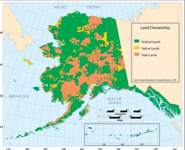
Native Claims Settlement Act (ANCSA) was signed by President Nixon in 1971 (Grant, 2010). Figure 3 is a map of general land ownership status in Alaska.
Figure 3. General land ownership status in Alaska. The state-owned land shown in the northeast portion of the state is situated between NPR-A to the west and ANWR to the east. (Source: Alaska Humanities Forum, ADNR)
ANCSA stated that Alaska Natives (the term Alaska Natives is used to indicate the indigenous peoples of Alaska) would forfeit aboriginal title to their lands in exchange for roughly 44 million acres of land divided among 220 villages and 12 regional Native-run corporations (see Fig. 4). These corporations would hold full title and subsurface rights
23
and administer cash payments from the Federal and State governments (Grant, 2010). These cash payments came in the sum of $962.5 million from the Federal government as compensation to Alaska Natives for extinguishment of aboriginal title to lands and to assist with the establishment of Alaska Native corporations that would hold fee simple absolute title or traditional western title to smaller areas of land (Ongtooguk, 1986). These Alaska Native corporations would in turn administer payments to their Alaska Native shareholders from investment revenues (Ongtooguk, 1986).
Figure 4. Map showing the 12 Alaska Native regional corporations. Arctic Slope Regional Corporation (ASRC) is the primary corporation associated with the Alaska Natives occupying the lands adjacent to the Beaufort and Chukchi Seas. (Source: ADNR)
In 1980, the Alaska National Interest Lands Conservation Act (ANILCA) effectively completed the “carving up” of Alaska lands into a complex patchwork of Federal, State,
24
and Native lands by determining what lands would be set aside for national parks, refuges, and other conservation areas; what lands were to be held by Alaska Native corporations; and what lands were available for the State to select (Gallagher, 1988). ANILCA came about as an attempt by the Federal government to reconcile controversy between
development and environmental interests in land use in Alaska, primarily as it pertained to access of public lands for specific purposes such as plane, boat, or snowmachine use ("Alaska National Interest Lands Conservation Act," 2011). ANILCA resulted in
approximately 104 million acres being designated to conservation systems in Alaska (see Fig. 5), though ANILCA specifically left the issue of whether or not to allow oil
development in ANWR, where the coastal plain is estimated to hold billions of barrels of oil, to a future vote by Congress (Hull & Leask, 2000).
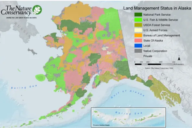
Since roughly 90% of Alaska lands are managed by Federal or State agencies (as of 2000, approximately 65% by Federal, 24% by State, and the remaining 11% managed by Alaska Native corporations or as private land—see Fig. 6), a high level of planning and coordination between Federal and State regulatory agencies is required in determining how areas should be managed (Todd, 2001).
25
Figure 5. Lands set aside as Federal conservation areas by ANILCA. The white block in the northeast corner of the state indicates the location of ANWR. (Source: Wikimedia Commons)
Each of these agencies must weigh the value of Alaska’s land, waters, and wildlife in addition to the competing economic interests of key stakeholders involved in
developing the State’s natural resources (Todd, 2001), such as oil and gas companies. In an ecologically sensitive area such as the Arctic, this coordination is paramount to success in safeguarding against environmental degradation while seeking to achieve maximum economic benefit.
26
Figure 6. Alaska land management status. (Source: The Nature Conservancy)
In terms of the submerged lands offshore in the Beaufort and Chukchi Seas, jurisdiction is split between State and Federal. Under the Submerged Lands Act of 1952 (43 U.S.C. §1301 et seq.), the State of Alaska owns all lands permanently or periodically covered by tidal waters up to, but not above, the line of mean high tide and seaward to a line three nautical miles from the coast (Tide & Submerged Land Ownership, 2000). After the three mile limit and until 200 nautical miles from the shore, the Federal government owns the submerged lands, subsoil, and seabed that comprise the Exclusive Economic Zone of the U.S., or EEZ, formally established by Presidential Proclamation 5030 in 1983 ("Outer Continental Shelf," 2014). Prior to this Proclamation, the Fishery Conservation and Management Act of 1976 (16 U.S.C. §1801-1882, 94 Pub. L. No. 265, 90 Stat. 331)
27
declared a Fishery Conservation Zone that extended from the State seaward boundary to 200 miles offshore. In 1977, the Act was retitled the Magnuson Fishery Conservation and Management Act (96 Pub. L. No. 561, 94 Stat. 3275) and in 1996, the Act was given its current name, the Magnuson-Stevens Fishery Conservation and Management Act (MFCMA) (104 Pub. L. No. 297, 110 Stat. 3009). This offshore area under Federal jurisdiction is referred to as the Outer Continental Shelf (OCS) for oil and gas planning.
Sea usage
Maritime usage of the Alaskan Arctic in the Beaufort and Chukchi Seas has a rich history and is still vastly important for the subsistence lifestyles of Alaska Natives living in the Arctic. The Beaufort and Chukchi Seas have been the site of continuous indigenous marine use, expeditions and explorations, and have experienced expanding use by the global shipping industry (Arctic Marine Shipping Assessment, 2009). The first explorers in the region were the indigenous peoples, who have used Arctic waters for thousands of years (Arctic Marine Shipping Assessment, 2009). Early Western exploration of the Arctic was primarily driven by the search for the Northwest Passage (NWP) which passes
through the U.S. portions of the Beaufort and Chukchi Seas (see Fig. 7), though it was not until 1906 that the Norwegian explorer Roald Amundsen became the first vessel to
complete the NWP (Arctic Marine Shipping Assessment, 2009). Whaling led to a great increase in the number of Arctic expeditions and was the most massive, sustained Arctic marine shipping activity, with over 39,000 whaling voyages between 1610 and 1915,
28
mainly led by the Netherlands, Germany, Britain, and the United States (Arctic Marine Shipping Assessment, 2009). These early voyages resulted in the loss of many sailors and ships due to hazardous sea ice and extreme weather conditions; however, those sailors that survived the journey gained specialized knowledge of sea ice distribution and ship
handling in ice, encouraging further expeditions (Arctic Marine Shipping Assessment, 2009).
Figure 7. Arctic shipping routes. (Source: The Arctic Institute)
In recent years, the reduction of summer sea ice coupled with better Arctic ship
29
economy—especially due to the growth of markets in Asia—have resulted in an increase of Arctic passages by ships, particularly along Russia’s Northern Sea Route (NSR) (see Fig. 7), which passes through Alaska’s Bering Strait (Brigham, 2011).
Alaska Native use of the Beaufort and Chukchi Seas
The Alaska Natives who have called and continue to call the Alaskan Arctic home have adapted to life in the harsh conditions present there and remain reliant on subsistence lifestyles, especially the abundant sea life in the Beaufort and Chukchi Seas, the two seas located on the U.S. Arctic Alaska OCS. The 2012 U.S. Census determined the population of the North Slope Borough, Alaska’s northernmost region that borders the Beaufort and Chukchi Seas, to be 9,643, with 52.9% of that population identifying as American Indian or Alaska Native (U.S. Census, 2012). ANILCA gave priority to hunting and fishing on Federal lands by rural residents of Alaska and in 1999, the Federal government took over regulation of subsistence fishing on navigable waters on or near Federal conservation units after a 1995 Federal court ruling, Katie John v. United States (Hull & Leask, 2000).
Katie John v. United States was a case in which Alaska Natives contested the rules designating certain Federal waters that were classified as “public lands” for rural subsistence hunting and fishing priority under ANILCA as too narrow (John v. United States, 2013). The ruling invalidated Dept. of Interior regulations that had exempted waters under Federal jurisdiction from the definition of “Federal public lands” and
30
take fish and game in these waters (John v. United States, 2013). With offshore oil and gas development, consideration of subsistence fishing and whaling plays an important part in Federal and State planning of projects, as accommodations must be made that allow subsistence activities to continue. Poor planning that could lead to a halt in subsistence activities due to releases of contaminants into the marine environment, disturbance of fish and marine mammal habitats, or other disturbances, could lead to a loss of food security for the subsistence users and result in litigation against the transgressor. While it is impossible to bring the risk of environmental accidents from oil and gas activities to zero, careful planning combined with Arctic-specific engineering standards and operating procedures can greatly reduce this risk. Additionally, local and Alaska Native knowledge, particularly of sea ice conditions and other hazards important to offshore oil and gas activities in the Beaufort and Chukchi often play an important—though informal—role in planning and emergency-response activities (Eicken, Ritchie, & Barlau, 2010). However, there is currently not a sufficient organizational structure to formally incorporate a
productive exchange of local and Alaska Native knowledge on the North Slope of Alaska (Eicken et al., 2010). It has been proposed that the creation of such an organizational structure to formally engage the local and Alaska Native stakeholders in mitigation and hazard planning could be more effective than merely soliciting public comment on projects (Eicken et al., 2010)
31
Marine Spatial Planning as a potential solution
MSP is a tool for managing an increasingly growing maritime economy while simultaneously providing a means to protect marine biodiversity, and has the potential to guide single sector management of marine activities toward integrated sea use
management (Douvere, 2008). MSP incorporates the concept of ecosystem-based management with more specific marine-based criteria and mapping for use by resource managers and for discussion by all stakeholders, taking into account the fact that specific activities only occur in certain areas of the ocean (Douvere, 2008). For example,
important ecological areas are found where there is a high diversity of species and productivity, while economic activities can only occur where their resources of interest are located; this is also the case on land, but MSP has to be adapted from land use planning to account for the “dynamic and three-dimensional nature of marine environments” (Douvere, 2008). Thus, MSP requires input from stakeholders to determine how all possible activities in a marine environment are ranked in terms of social importance.
Due to its wicked nature, the planning of Beaufort and Chukchi oil and gas development requires an innovative approach to address the unique complexities that stakeholders, including project planners, face in the these seas (Kämpf & Haley, 2011). For this reason, Federal and State planners should work together closely to draw upon all available Arctic expertise from a social, cultural, economic, and environmental
32
offshore Beaufort and Chukchi oil and gas. This should include providing an opportunity to engage all stakeholders in the planning process and to account for multiple uses of the marine space that may impact each other. Such a coordination of efforts, perhaps through MSP, could result in proactive management and conservation of marine and coastal resources while simultaneously allowing for the economic benefits of further development in the Arctic region. NGOs can be involved in MSP as stakeholders, but can also serve as organizing parties or driving forces for MSP (Calado et al., 2012). Since NGOs play an independent role in society, they can help to encourage public participation as organizing parties or driving forces in MSP though community organization, training, research, education, advocacy, and, by partnering with academic entities and local government agencies, can help with project implementation, knowledge transfer, data collection, monitoring, and evaluation (Calado et al., 2012).
One important consideration when exploring MSP as a viable tool for use to address the wicked problem of oil and gas development in the Beaufort and Chukchi Seas is the existing regulatory structure present. In a study comparing the U.S. and Canadian regulatory approaches for oil and gas, with the former being characterized by command-and-control regulations that focus on technology and Canada being characterized by a more flexible approach focused on environmental impacts, no significant differences were found in the corporate environmental strategies of oil and gas companies operating in each of the countries (Sharma, 2001). Further, this study indicated that regulations appear to be important drivers of corporate environmental practices at initial stages of planning, but other external and internal drivers become stronger influences after these initial
33
stages, suggesting that a combination of both regulatory approaches, more stringent at the beginning and more flexible at later stages, may help to produce a higher level of
environmental protection while still allowing for technological innovation and competitiveness among companies (Sharma, 2001). Managi et al. (2005) further strengthened support for a regulatory approach that allows for greater technological innovation and competitiveness at later stages by showing that, over a 28-year study period of environmental regulation and technological change in Gulf of Mexico (GOM) offshore oil and gas, technological change was partitioned into roughly 80% in the market sector (oil and gas production) and 20% in the environmental sector (Managi, Opaluch, Di, & Grigalunas, 2005). In other words, environmental regulation-driven technological change resulted in fewer oil spills and greater water quality, but the amount of
technological change resulting from command-and-control regulations lagged behind the amount of change resulting from market forces (i.e., increased oil and gas production) (Managi et al., 2005). These findings suggest that an overly optimistic view of the potential of environmental regulations for driving technological change and improved environmental quality in offshore oil and gas could lead to poorly designed environmental policies (Managi et al., 2005) and the regulatory approach should be flexible enough to include opportunities for innovation by companies so that environmental technology can keep pace with increased production. In order to avoid severe environmental degradation in the Beaufort and Chukchi marine and coastal environments, this more flexible
regulatory approach for the later stages of oil and gas in the Arctic should be considered when developing new planning mechanisms, such as MSP, so that innovative
34
technologies that help maintain a high level of environmental quality are encouraged and that opportunities for this innovation to keep pace with the predicted increase in offshore production are incorporated into the planning.
The regulatory structure in the U.S. and Alaska currently allow for public participation in the permitting of projects (detailed in section 4), meaning that public participation has the potential to shape these permitting requirements. Incorporating elements of the wicked problem in development of an MSP process for the Beaufort and Chukchi Seas could be one potential option to improve current and future offshore oil and gas planning in the region by, among other potential benefits, aiding stakeholders through the public participation channels for which the current Federal and State permitting process allow.
35
2. METHODOLOGY
This research reviews current permitting processes that provide insight into the Arctic Alaska oil and gas management strategies of the U.S. Federal Government and the State of Alaska, one element of the wicked problem of oil and gas development in the Beaufort and Chukchi Seas. In addition to an overview of the permitting processes, a critical look at the U.S. National Strategy for the Arctic Region, particularly as it relates to planning and permitting of oil and gas development and how the State responds to it, is provided. The analysis of these planning and permitting approaches provide insight into the priorities that the Federal and State entities consider when deciding whether or not to allow particular oil and gas development projects in Alaska’s Beaufort and Chukchi Sea coastal and marine areas.
Further discussion of wicked problem characteristics of Beaufort and Chukchi Sea oil and gas development is included to demonstrate the need for an improved
collaborative decision-making structure for stakeholders, one that balances economic interests with environmental protection in the this Arctic marine and coastal environment. Suggested improvements to the issue of stakeholder engagement are weighed in the context of MSP, which could provide one possible tool to achieve this goal of economic development and environmental protection. MSP is a sub-activity of overall sea use management and has been promoted as a means to unite stakeholders through long-term, policy oriented regional decision-making, implemented through detailed zoning maps, zoning regulations, and/or a permit system (Douvere & Ehler, 2009), similar to land use
36
planning. Rather than a piecemeal, top-down regulatory approach, a proper application of MSP could potentially result in a comprehensive bottom-up approach to Arctic offshore oil and gas planning that truly engages stakeholders in a meaningful way, instead of simply fulfilling legal obligations to allow for public input, helping to avoid adversarial struggles, and serving as a method to strive for cooperative stewardship in the Arctic region. This qualitative analysis of Federal and State approaches for offshore oil and gas permitting in the U.S. Arctic will be further strengthened by examining Rhode Island’s Special Area Management Plan (SAMP), the first marine spatial plan in the U.S. to be approved by the Federal government as part of a state’s Coastal Zone Management Program (CZMP). This case study provides a basis for examining if the approach used in Rhode Island and its attempt to incorporate a high level of stakeholder engagement in the offshore development planning process could potentially be adapted to improve the Federal and State planning for future offshore oil and gas projects in the Beaufort and Chukchi Seas. While the MSP used in Rhode Island may have been successful, there are many differences to consider for MSP when examining its applicability for the Beaufort and Chukchi Seas, an area with an entirely different set of political, social, cultural, economic, environmental, and technical factors than Rhode Island. However, the act of bringing together stakeholders from various industries and interests is present in the Rhode Island case and this example of stakeholder engagement is the focus.
37
Limitations and assumptions
The Alaska Coastal Management Program (ACMP), a voluntary effort under NOAA’s National Coastal Zone Management Program to implement coastal zone plans at the State level, expired in 2011 and was not reauthorized by the Alaska State Legislature; a ballot initiative to reinstate the program was written in 2012 but was voted down, making Alaska the only coastal state in the U.S. currently without a Coastal Zone Management Program (CZMP). One proponent of the 2012 ballot initiative, a former Alaska governor, argued that the Alaska CZMP had helped to coordinate permitting between Federal and State agencies in the past (Knowles, 2012), while one opponent of the initiative, another former Alaska governor, argued that the way the 2012 initiative was written was entirely different than the original Alaska CZMP, resulting in a program that would duplicate efforts of existing State agencies, particularly the Alaska Department of Natural Resources (ADNR) (Murkowski, 2012). After the expiration of this State
program, permitting and oversight of coastal management fell under the responsibility of the ADNR, which had existing permitting authority prior to the Alaska CZMP. For this reason, there is no single, overarching State coastal management plan to examine in this study and hence, State oil and gas permitting, leasing, and authorization requirements serve as the substitute. Additionally, the evaluation of the potential use of MSP in the Beaufort and Chukchi Seas partially relies on an example from Rhode Island, where MSP was incorporated as part of the State CZMP and where there is an entirely different
38
political climate than in Alaska. In order to account for these stark differences, recent statements from State agency and industry representatives in Alaska indicating concerns about the implementation of MSP in the Alaskan offshore are considered.
39
3. OVERARCHING LEGAL CONTEXT AND ECONOMIC CONSIDERATIONS
Before discussing the permitting process of the U.S. Federal Government and the State of Alaska, it is necessary to survey the overarching legal regimes, treaties, and statutes applicable to environmental protection in the Arctic marine environment of the Beaufort and Chukchi Seas. In addition, a brief overview of economic forecasts for offshore oil and gas development in these areas is provided to describe potential
development scenarios for the region. These factors play an important role in the oil and gas planning process and can dictate where and when resources are developed,
contributing to the wicked problem.
Legal regimes and statutes
The Third United Nations Convention on the Law of the Sea and the Ilulissat Declaration
The Third United Nations Convention on the Law of the Sea (UNCLOS III), which concluded in 1982, is a treaty among member nation-states regarding the use of the world’s oceans and the jurisdiction of the continental shelves of nations. The treaty, among many other provisions, sets forth a boundary for territorial waters—12 nautical miles from the nation’s coastline—as well as the EEZ, or Exclusive Economic Zone, which extends 200 nautical miles from the nation’s coastline (Attard, 1987). Within the
40
EEZ, the nation-state has exclusive right to the living marine resources and mineral resources, and can regulate pollution from ships entering the EEZ for innocent passage. Article VI of UNCLOS III establishes the International Seabed Authority (ISA) for the regulation and taxation of seabed, ocean floor, and subsoil resources extracted in the high seas of the areas outside of the 200 nautical mile EEZ limit ("About Us - International Seabed Authority," 2013). The U.S. has signed but not ratified UNCLOS III; however, the U.S. follows a policy that is consistent with most parts of the Convention and many key norms in UNCLOS III reflect customary international law, binding on all nations (Ripley, 2011).
Annex II of UNCLOS III provides an explanation for the method to be used in establishing the outer edge of a nation’s continental margin beyond 200 nautical miles and is in accordance with Article 76, which establishes a Commission on the Limits of the Continental Shelf (CLCS) to aid in this determination. The CLCS can recommend the
delineation of the outer limits of the OCS of an individual nation and this delineation is to be established unilaterally; however, the delimitation of any overlapping boundaries between coastal nations is to be resolved by treaty between the applicable parties (Ripley, 2011). Though Russia, Norway, and Denmark have submitted claims for areas in the Arctic beyond their 200 nautical mile EEZs to the CLCS, and Canada is expected to do so ("CLCS: Partial Submission by Canada," 2014), offshore oil and gas development beyond the existing EEZs is “highly unlikely during the foreseeable future (Young, 2009; AMAP, 2007).
41
One Arctic territorial dispute of concern for the U.S. is that regarding the delimitation of its maritime border in the Beaufort Sea with Canada, where an area of 22,600 km2 rich in fisheries and, likely, oil and gas, is at stake (see Fig. 8) (Kříž & Chrášťanský, 2012). The U.S. holds the position that the border has not yet been defined and prefers the median approach between the countries, while Canada cites an 1825 agreement between Great Britain and Russia using the 141st meridian as the border (Kříž
& Chrášťanský, 2012). This 1825 agreement, however, uses the vague term “as far as frozen ocean” in its border demarcation and the date and signatories of the agreement raise further questions as to its legal force (Kříž & Chrášťanský, 2012).
Figure 8. International borders in the Arctic Ocean. The area in orange indicates the disputed area between the U.S. and Canada. (Source: University of Durham)
42
It has been suggested that all territorial disputes in the Arctic Ocean and its adjacent seas could be resolved under the legal framework provided by UNCLOS III, though the U.S. is the only one of the five states bordering the Arctic Ocean who has not ratified the
Convention (Ripley, 2011).
UNCLOS III provides a general framework for environmental protection in Part XII, “Protection and Preservation of the Marine Environment.” This framework applies to all uses, including the sovereign right of nation-states to conduct oil and gas exploration and exploitation on their continental shelves, though nation states have the obligation to “protect and preserve the marine environment” (Casper, 2009). These obligations include, among other provisions, ensuring that activities in a nation-state’s jurisdiction that result in pollution do not cause trans boundary harm and require nation-states to cooperate with other nation-states and “competent international organizations” in developing rules, standards, best practices, procedures, monitoring requirements, and conducting scientific research to aid in the prevention of marine pollution (Casper, 2009).
In May 2008, the five Arctic nations that border the Arctic Ocean, Canada, Denmark (through its autonomous province of Greenland), Norway, Russia, and the United States, met to discuss and sign the Ilulissat Declaration to highlight their position as coastal nations with sovereign rights and responsibilities in the Arctic Ocean who were committed to following procedures that delimit outer continental shelves. This Danish-led initiative was designed to challenge the notion that a new comprehensive international legal regime should be established to govern the Arctic Ocean and that the existing legal framework under UNCLOS III is sufficient (Dodds, 2013). Absent from this meeting