OH DEER: IDENTIFYING NATIVE HUNTING TERRITORIES IN THE NORTH CAROLINA PIEDMONT USING STRONTIUM (87Sr/86Sr) ISOTOPE ANALYSIS
Christine Anna Mikeska
A thesis submitted to the faculty at the University of North Carolina at Chapel Hill in partial fulfillment of the requirements for the degree of Master of Arts in the Department of
Anthropology
Chapel Hill 2020
© 2020
ABSTRACT
Christine Mikeska: “Oh Deer: Identifying Native Hunting Territories in the North Carolina Piedmont Using Strontium (87Sr/86Sr) Isotope Analysis
(Under the direction of Benjamin Arbuckle)
To Shupi, I couldn’t have done this without you.
ACKNOWLEDGEMENTS
TABLE OF CONTENTS
LIST OF TABLES...vii
LIST OF FIGURES...vii
LIST OF TABLES...viii
LIST OF ABBREVIATIONS...ix
CHAPTER 1: INTRODUCTION...1
CHAPTER 2: DEER EXPLOITATION IN THE MID-ATLANTIC AND SOUTHEAST...4
Ethnohistorical Accounts...4
Zooarchaeological Evidence of Deer Exploitation...12
CHAPTER 3: ARCHAEOLOGICAL SITES AND HISTORICAL CONTEXT...17
The Wall Site...18
The Jenrette Site...19
The Fredricks Site...21
The Hairston Site...24
The Upper Saratown Site...25
Deer Exploitation at the Eno and Dan Rivers...26
CHAPTER 4: METHODS...30
Strontium Isotopes...30
The Geological Terranes of North Carolina...32
CHAPTER 5: RESULTS...38
General Trends in 87Sr/86Sr Composition...38
87Sr/86Sr Values of Eno River Individuals...46
87Sr/86Sr Values of Dan River Individuals...49
Comparison of Eno and Dan River Individuals...52
CHAPTER 6: DISCUSSION...56
General Trends...56
Diachronic Trends from the Eno River Individuals...57
Diachronic Trends from the Dan River Individuals...59
Continuity and Change: Deer Exploitation in the Post-Contact Period...64
CHAPTER 7: CONCLUSION...70
REFERENCES...72 55 55 56 58
LIST OF FIGURES
Figure 1: Map of Eno and Dan River sites, as well as the Indian Trading Path...18
Figure 2. %NISP of deer at the Eno and Dan River sites...28
Figure 3. %Biomass of deer at the Eno and Dan River sites...29
Figure 4. Geological terranes of North Carolina...36
Figure 5. Approximate Sr isoscape of North Carolina...37
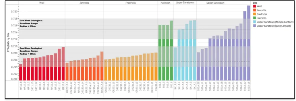
Figure 6. 87Sr/86Sr values of deer samples from the Eno and Dan River sites with baseline Sr values covering an area of 35km2...43
Figure 7. 87Sr/86Sr values derived from Molars 1, 2, and 3 from the same mandible...44
Figure 8. 87Sr/86Sr values of archaeological rodent samples...45
Figure 9. Histogram of 87Sr/86Sr values from the Eno River individuals...48
Figure 10. Histogram of 87Sr/86Sr Values from the Dan River individuals...51
Figure 11. Histograms of 87Sr/86Sr Values from the Eno and Dan River individuals...53
Figure 12. Parameters of minimum estimated hunting territory used by Eno and Dan River communities based on Sr values...60
Figure 13. Parameters of minimum estimated hunting territory used by Eno River communities based on Sr values...61
LIST OF TABLES
Table 1: %NISP and %Biomass of Deer by Site...28
Table 2: 87Sr/86Sr Values from Eno and Dan River Individuals...40
Table 3. Levene's test p-values: Contemporary Sites...54
LIST OF ABBREVIATIONS
31OR11 The Wall Site
31OR231A The Jenrette Site
31OR231 The Fredricks Site
31SK1 The Hairston Site
31SK1A The Upper Saratown Site
Ca. Approximately
MNI Minimum Number of Individuals
NCDEQ North Carolina Department of Environmental Quality
NISP Number of Identified Specimens
CHAPTER 1: INTRODUCTION
Archaeological and ethnohistorical sources indicate that white-tailed deer (Odocoileus virginianus) were the single most important faunal resource exploited by Native American
communities across the Mid-Atlantic and Southeast for millennia. A widely accessible and extremely valuable resource, a single deer would provide Native communities far more meat by weight than any other available faunal resource, while the rest of the carcass provided a diverse array of products to Native communities, including leather, tools, and even musical instruments (Lefler 1967:29, 217; Swanton 1946:249). Previous scholarship on deer exploitation within the Mid-Atlantic and Southeast has focused on taphonomic and taxonomic characteristics of faunal assemblages, identifying the central role of deer within Native subsistence economies, as well as changes in exploitation through time (Holm 1994; Lapham 2005; Longo 2018; Waselkov 1978; Vanderwarker and Stanyard 2009). However, the spatial parameters of deer hunting territories have not previously been addressed, particularly in the case of provisioning residential villages, the dominant settlement type of the late Precontact Period in the region. Using Sr isotopes from archaeological deer teeth, this study builds on previous work on Indigenous deer exploitation, specifically addressing the spatial dimension of deer exploitation in the North Carolina Piedmont during the late Precontact, Middle Contact, and Late Contact Periods.
new spatial information about deer exploitation at these five sites, providing further
contextualization of Native exploitation practices as they concern the most important animal resource available to these communities. Unlike many large mammals, deer occupy very small home ranges and thus function as a good source for identifying hunting territories. While there is some seasonal variability in home range, deer are known to inhabit the same home range year after year, occupying areas between 16 and 135 hectares (Trani and Chapman 2007:535). Therefore, because of the boundedness of their home ranges, the teeth of adult deer should reflect the Sr values of specific local geographies. As a result, Sr values derived from tooth enamel are a useful proxy for estimating the general geographic parameters of the hunting
territories used to provision villages in the Eno and Dan River Basins. Situating these data within the broader cultural contexts of the Pre- and Post-Contact Periods, this study identifies the
minimum geographic parameters of hunting territories used by Native communities, as well as changes to these territories through time and between regions. Through the comparison of archaeological Sr isotope ratios (87Sr/86Sr) from deer enamel to values generated from geological baselines, which form the regional Sr isoscape, these data are applied to the following research questions relating to deer exploitation and hunter mobility:
1. What were the minimum geographic parameters of hunting territories exploited by Native hunters from residential sites in the Eno and Dan River Basins? Were most deer harvested locally (<35km) or is there evidence for the hunting and transport of deer to residential sites from more distant hunting grounds? 2. Did hunting territories change over time and, if so, how?
The primary goal of this study is to identify the minimum geographic parameters of hunting territories exploited by communities in two regions of the North Carolina Piedmont. In the case of this study, the term “territory” is used in reference to Site Exploitation Territories (SETs), which refers to the geographic area of habitual exploitation. This concept is intentionally separated from the concept of “territoriality,” which implies ownership, defensibility, or
exclusivity of use, none of which are implied within the scope of this study (Bailey and
Davidson 1983:88; Dyson-Hudson and Smith 1978:22; Peterson 1979:55). The samples selected for Sr analysis were recovered from residential sites and are thus assumed to represent those deer that were exploited in order to provision the settlements themselves. Models of carcass
processing predict that deer exploited far from permanent settlements are likely to be processed at kill sites, and elements such as crania and distal extremities are less likely to be transported back to the permanent settlement (Perkins and Daly 1968:104). As a result, this project, which samples teeth, is expected to address only a portion of the total spatial distribution of deer exploitation, likely underrepresenting distant hunting territories. Based on models of carcass processing and transport, it is expected that the majority of deer analyzed in this study, and for which dental elements are transported to a village site, will have been harvested locally (<35km, based on ethnographic comparison). The identification of distant hunting territories would therefore be of particular interest, suggesting the long distance transport of whole deer carcasses by human porters or via waterways –behaviors not well documented in the ethnohistoric record.
hypothesized that hunting territories will change from the late Precontact Period to the Contact Period as a result of disruptions caused by European colonization and the diverse responses of Native communities. In particular, it is likely that the market for deer hides, which emerged as a major economic factor in the 17th century, affected Native hunting strategies, as well as perhaps deer populations themselves. It is thus hypothesized that the two different site locations, one closer to and one more distant from colonial settlements, will result in different engagements with the deerskin trade and differences in deer exploitation strategies that will be reflected in the scale of hunting territories.
CHAPTER 2: DEER EXPLOITATION IN THE MID-ATLANTIC AND SOUTHEAST Ethnohistorical accounts from the Post-Contact Period emphasize the importance of deer in Native subsistence economies, with European colonists and explorers describing the
functional utility of deer productions, Native hunting techniques, and the impact of deer hunting on seasonal mobility decisions. However, while these ethnohistorical sources provide a useful starting point from which to understand Pre- and Post-Contact hunting strategies, the strategies they describe and the European perspective from which they are written are intrinsically linked to their historical and colonial context. In order to more fully understand the deer hunting strategies of Native communities both before and after European colonization, it is necessary to contextualize the available ethnohistorical accounts using archaeological data. In combining these two bodies of evidence, scholars have developed several models for understanding Native deer exploitation in the Mid-Atlantic and Southeast.
Ethnohistorical Accounts
European ethnohistorical accounts of Native hunting strategies begin as early as the late 1500s, with explorers and colonists documenting the English colonial encounter in the Mid-Atlantic and Southeast from its onset. These sources describe the diversity of hunting strategies deployed by Native communities, detailing a wide range of hunting methods, seasonal hunting decisions, and distances traveled in order to hunt. These accounts emphasize the diversity of exploitation strategies used by communities across the region. Though these accounts
tantalizing glimpse into Native hunting practices and provide some degree of context to archaeological evidence of deer exploitation both before and after European contact. Though these accounts occasionally note the diverse array of products produced from deer exploitation within the traditional subsistence economies of the Mid-Atlantic and Southeast, they tend to highlight a general trend towards increasingly specialized deer exploitation strategies during the Contact Period, emphasizing the importance of the historic deerskin trade in exploitation
decisions.
The most geographically and temporally relevant ethnohistorical account of deer exploitation comes from John Lawson, an eighteenth-century explorer and author of A New Voyage to Carolina (Lefler 1967), in his description of deer exploitation strategies in the North
Carolina Piedmont. Lawson provides a comprehensive list of products produced from deer carcasses, highlighting the importance of deer exploitation in almost ever facet of Native life. In addition to providing the largest source of animal protein and fats to Native diets, deer carcasses were partitioned in a wide range of tools and products by Native communities. Lawson notes that deer hides were traditionally used to make a wide variety of Native products, including clothes, shoes, and drums, though ethnohistorical sources, including that of Lawson himself, tend to focus largely on the value of deer hides within the historic deerskin market (Lefler 1967:29, 51, 58, 217). Furthermore, Lawson notes that the hides themselves were produced from tools and substances made of other parts of the deer, namely brain tissue and metapodials (Lefler
the deer carcass could be further partitioned into other products, such as bracelets fashioned from ribs, flutes from tibiae, and awls from ulnae (Swanton 1946:249). Sinew and skin were shaped into fishnets and bowstrings, antlers and hooves were boiled to make glue or worked into tools and ornaments, and crania and skins were used to make hunting decoys – one of several hunting methods documented in the region (Lefler 1967:29; Swanton 1946:249). Lawson’s account demonstrates that traditional Native subsistence economies of the North Carolina Piedmont relied heavily on deer exploitation and the products derived from deer carcasses.
The use of hunting decoys, as noted in Lawson’s account, is one of several
ethnohistorically documented methods of deer hunting within the Mid-Atlantic and Southeast. Decoy hunting is a method of stalking, which involves the hunter wearing the antlers, skull, and hide of a deer in order to mask his presence (Waselkov 1978:20). Jamestown colonist, John Smith, describes the use of decoys by Powhatan hunters in Virginia, noting:
One Savage hunting alone, useth the skinne of a Deare slit on the one side, and so put on his arme, through the neck, so that his hand comes to the head which is stuffed; and the homes, head, eies, eares, and every part as arteficially
counterfeited as they can devise. Thus shrowding his body in the skinne, by stalking he approacheth the Deare, creeping on the ground from one tree to another. If the Deare chance to find fault, or stande at gaze, hee tumeth the head with his hand to his best advantage to approach, having shot him, hee chaseth him by his blood and straine till he get him (Smith 1910:70-71).
among high reedes, where oftentimes they finde the Deer asleepe, and so kill them” (Quinn and Quinn 1973:98).
Ethnographic sources, including that of John Lawson, also describe the use of communal drives by Native communities in the Virginia and North Carolina territories (Waselkov 1978:25). A 1728 account by William Byrd details the use of drives by Saponi hunters in Virginia, who “drove the Woods in a Ring […] from the circumference of a Large Circle they all march’t inwards, and drove the Game towards the center” (Byrd 1967:244). Jamestown colonist Henry Spelman describes Native hunters in Virginia deploying fire to drive deer. While smaller drives using fire may have involved fewer people, ethnographic sources describe the involvement of several hundred hunters working in unison to drive and kill large quantities of deer:
Ther maner of ther Huntinge is thiss wher they meett sum 2 or 300 togither and havinge ther bowes and arrows and every one with a fier sticke in ther hand they besett a great thikett round about . . . which ye Deare seinge fleeth from ye fier, and the menn comminge in by a litell and litle incloseth ther game in a narrow roome, so as with ther Bowes and arrowes they kill them (Smith 1910:cvii). John Smith also describes the use of communal drives by fire to kill between 6 and 15 deer in a given drive:
them into the river, where with their boats they have Ambuscadoes to kill them (Smith 1910:70-71).
In addition to documenting individual and group hunting methods, Lawson’s account further documents the use of hunting grounds located some distance away from permanent settlements within the Mid-Atlantic and Southeast, with Lawson noting that hunters “commonly go out in great Numbers, and oftentimes a great many Days Journey from home” (Lefler
1967:215). Accounts such as Lawson’s suggest the use of particular hunting territories located anywhere between tens and hundreds of miles away, depending on the community, product priorities, and season. Deer exploited from these hunting camps may therefore not be represented within settlement faunal assemblages, having been processed and discarded away from
settlements.
However, despite the glimpses into Native hunting practices provided by ethnohistorical accounts, these datasets are very much a product of their historical and colonial context. This is most evident in colonial descriptions of the diminishing role of seasonality and increasing importance of deerskins to Contact Native hunting strategies. While Lawson notes “the Deer-Skins [were] in Season in Winter” (Lefler 1967:216) and the eighteenth-century trader, James Adair, describes Choctaw men spending the “winter hunt[ing] in the woods” (Adair 1968:284), Virginian colonist Ralph Hamor’s 1615 account describes the year-round hunting of deer by Coastal Native communities:
While these discrepancies may also be a product of differing traditional hunting strategies by disparate communities located in different environments across the Southeast, historian Joshua Piker notes that by and large by the mid eighteenth-century seasonality factored less and less into the exploitation strategies of Native Southeastern communities. Piker states, “the winter hunt [of the Creek] expanded to such a degree that it merged with the summer hunt, traditionally both a shorter and less important undertaking than its cold-weather counterpart” (Piker 2004:81). Piker also notes increasing competition over rights to hunting territories and the expansion of existing territories into new areas (Piker 2004:81). Though Piker describes the exploitation strategies of the mid eighteenth-century Muskogean speaking groups situated to the southwest of the region on which this study focuses, the circumstances described by Piker parallel the
Bowes and arrows they kill them at ther pleasuer takinge ther skinnes which is the greatest thinge they desier, and sume flesh for their provision” (Smith 1910:cvii), presumably describing
extensive exploitation of deer in order to participate in the deerskin trade. Even Lawson situates his description of Native hunting strategies within the context of the deerskin trade, concluding, “Here it is, that they get their Complement of Deer-Skins and Fur to trade with the English” (Lefler 1967:216).
Documentation of Native communities trading deerskins for European goods begins as early as 1584 with Roanoke colonist, Authur Barlowe, who notes the relative worth of the skins compared to European goods:
A daye or two after this, we fell to trading with them, exchanging some thinges that we had for Chammoys, Buffe, and Deere skinnes […] We exchanged out tinne dishes for twentie skinnes, woorth twenties Crownes, or twentie Nobles: and a copper kettle for fiftie skinnes woorth fiftie Crownes (Quinn and Quinn 1973:4-5).
Barlowe’s account is echoed by fellow Roanoke colonist, Thomas Harriot, who further notes the mass quantities of deerskins acquired from Native hunters by way of trade as early as 1588:
Deere skinnes, dressed after the maner of Chamoes or undressed, are to be had of all the natural inhabitants thousands yearly by the way of traffique for trifles, and no more waste or spoile of Deere than is and hath bene ordinarily in time before (Quinn and Quinn 1973:52).
eighteenth-centuries, with records noting that over two million deerskins were exported from the Virginia and Carolina territories to Great Britain between 1698 and 1724 (Crane 1928:328). By the eighteenth-century, the deerskin market had grown so large that colonists saw fit to establish the Carolina Commissioners of Indian Trade, regulating trade and controlling profit margins through the standardization of the market (Lapham 2005:12). Regulated prices, based on hide quality and size, suggest a preference towards large, processed hides, though late eighteenth-century accounts suggest that the European market had developed a preference toward raw hides, to be processed following purchase from Native hunters in order control the quality of tanning for European markets (Lapham 2005:11).
The development and maintenance of the deerskin trade relied largely on Native
participation and exploitation decisions, despite colonial attempts at management and regulation. The active engagement of Native communities in the developing deerskin trade is one of several factors that likely resulted in a diversification of exploitation practices across the region during the Post-Contact Period, with some communities retaining traditional subsistence economies and others adapting their exploitation strategies to more intensively participate in the growing market (Lapham 2005; Waselkov 1978:26). This diversification is evident in ethnohistorical accounts from the period, which are at times conflicting depending on the community, region, and period in question. While part of this conflict probably also arises from the fact that these accounts were written from the perspective of European colonists, resulting in biased and potentially
oversimplified descriptions of otherwise diverse and complicated Native subsistence and
Zooarchaeological Evidence of Deer Exploitation
Zooarchaeological evidence provides another perspective from which to study Native deer hunting strategies within the North Carolina Piedmont. In addition to the archaeological evidence recovered from the sites on which this study focuses, which will be presented in the following section, this study is informed by three foundational case studies that use
zooarchaeological evidence to understand Native hunting practices in the Mid-Atlantic and Southeast. In the first case study, Waselkov (1978) focuses on identifying Native hunting
methods using faunal evidence, attempting to differentiate between faunal assemblages resulting from stalking and those resulting from communal drives. Next, Lapham (2005) uses several lines of archaeological evidence to create a holistic model of deer exploitation and trade participation by Native individuals and communities in the Mid-Atlantic, using both faunal data and trade goods. Finally, Vanderwarker and Stanyard (2009) use faunal evidence to identify the Sandy site, located on the North Carolina Coastal Plain, as a temporary, Precontact hunting camp. This final case study informs this study in that it establishes the use of temporary hunting camps by Native communities in North Carolina.
Attempting to identify the hunting techniques used by Native communities across the Midwest and Southeast, Waselkov (1978) constructs mortality profiles of archaeological deer from 20 Pre- and Post-Contact sites. Identifying both bimodal, which represent the exploitation of both young and old individuals, and unimodal, focused on prime-aged individuals,
of young and, to a lesser extent, old deer, demonstrate that Precontact communities relied largely on stalking, assuming that young and old individuals are more easily killed, while unimodal distributions, focused on prime-aged individuals, indicate that Post-Contact communities participated in communal drives. While natural populations of deer tend to be dominated by young individuals, Waselkov compares the observed unimodal age distributions to prehistoric bison kill-off patterns observed in assemblages from the Great Plains, in which juveniles are also underrepresented. Due to the similarities between these distributions, Waselkov identifies these unimodal distributions from sites in the Midwest and Southeast as evidence of communal drives.
Based on these interpretations of the age-distributions of exploited deer, Waselkov suggests that smaller Post-Contact communities shifted their exploitation practices towards communal drives with the advent of European colonization and the introduction of the historic deerskin trade in order to more intensively exploit local hunting grounds. He argues that this strategy was intended to offset the devastating effects of disease and warfare, which would have limited the population of hunters available to exploit deer and generally contribute to the
subsistence economy in smaller-scale Native communities. In contrast, Waselkov argues, larger communities such as the Cherokee and Iroquois were more easily able to buffer themselves against external pressures and therefore did not need to alter their hunting strategies following European settlement.
below). Regardless of the specific method deployed by the Native communities under study, however, Waselkov’s data does indicate a shift in deer exploitation strategies following European contact.
Lapham’s (2015:15) “hunting for hides” model provides another archaeological method of assessing changes in Native deer exploitation practices. The “hunting for hides” model assumes that some Post-Contact Native communities shifted their deer exploitation practices from a traditional model of exploitation, which emphasized deer as a multi-faceted resource for food and other products, towards a strategy that emphasized the production of economically valuable deerskins. Lapham argues that the “hunting for hides” model can be demonstrated by an overall increase in the importance of deer within faunal assemblages, increasingly selective hunting strategies evidenced by the selective harvesting of prime-aged deer (particularly males due to the economic benefits of large hides), and an increase in year-round hunting as evidenced by age data and antler development. Additionally, there are some data to indicate that butchery practices shift to maximize hide removal, though this is less well documented. This model stands in contrast to Precontact deer exploitation strategies, which focus largely on the seasonal
exploitation of juveniles and occasionally older adult deer, as evidenced by multiple zooarchaeological assemblages from the Crab Orchard (44TZ1), Hoge (44TZ6), and Trigg (44MY3) sites in Virginia. These criteria provide the best model for understanding
zooarchaeological faunal evidence and overall patterns of Native deer exploitation during the Pre- and Post-Contact Periods in the Mid-Atlantic and Southeast.
Lapham (2005) further ties these changes in hunting strategy to the development of the historic deerskin trade through the analysis of European trade goods within Post-Contact
and Native intermediaries working within developing trade networks. Lapham notes that the development of trade relationships with European colonists, as well as with Native
intermediaries, created new opportunities for the acquisition of social prestige and political authority, emphasizing the active involvement of Native communities and individuals in the development and maintenance of the deerskin trade. This model shifts agency back to Native communities and individuals of the Post-Contact Period, while also acknowledging the potential for multiple exploitation strategies and ways of negotiating the changing social landscape of the seventeenth- and early eighteenth-centuries.
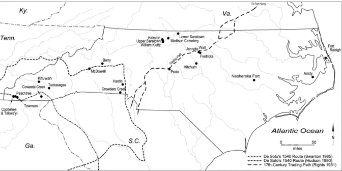
CHAPTER 3: ARCHAEOLOGICAL SITES AND HISTORICAL CONTEXT This study focuses on five village sites within the Eno and Dan River drainages (Figure 1) with phases dating to the Precontact (A.D. 1526 – 1625), Middle Contact (A.D. 1626 – 1675), and Late Contact Periods (A.D. 1675 – 1710), the latter two of which are referred to as the Post-Contact Period within this study. The Wall (31OR11), Jenrette (31OR231A), and Fredricks (31OR231) sites are situated adjacent to one another within a bend in the Eno River in Orange County, North Carolina, whereas the Hairston (31SK1) and Upper Saratown (31SK1a) sites are located near the mouth of one of the major tributaries of the Dan River in Stokes County, North Carolina (Figure 1; Ward and Davis 2005:132). These sites were selected for analysis based on their proximity to each other, as well as their general environmental and chronological similarity (Ward and Davis 1991:171). All of the sites are located along rivers in environments consisting of hills and woodlands. Furthermore, the Wall, Jenrette, and Fredricks sites are roughly
contemporaneous with the Hairston site, and the Middle and Late Contact Upper Saratown site, respectively.
Despite their similarities, there are two important differences between these sites that may have effected exploitation decisions, particularly in the Post-Contact Period. Firstly, the Eno River sites are located on the Indian Trading Path, an important trade route for the historic
approximately 90km to the west, are more distant from centers of European settlement. Secondly, the Dan River sites are located closer to the Blue Ridge Mountains, a resource-rich upland
environment located in western North Carolina. Proximity to these two important geographic features may have effected Native exploitation decisions in important and unique ways.
Figure 1. Map of Eno and Dan River sites, as well as the Indian Trading Path (RLA 2019)
The Eno River Sites The Wall Site (31OR11)
the Siouan Project has clarified site chronology, with calibrated radiocarbon dates averaging A.D. 1545±80 (Ward and Davis 2005:129). Within this study, samples selected from the Wall site provide a window into late Precontact deer exploitation strategies within the Eno River drainage.
Excavation of the Wall site has revealed a small settlement containing several circular housing structures of single-post construction surrounded by a series of palisades. The nucleated village is estimated to have contained between 15 and 20 households, housing a population of about 100-150 individuals (Davis and Ward 1991:175). Site occupation has been estimated on the order of several decades, as evidenced archaeologically by site expansion, housing
maintenance, and substantial midden accumulation at the north edge of the site (Petherick 1987). Scholars have concluded that the Wall site occupation represents a period of increasing
population density, as well as resulting intensification and diversification of subsistence practices (Ward and Davis 2005:121).
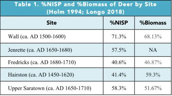
Zooarchaeological analysis confirms that deer played a key role in the subsistence economy at the Wall site, with deer dominating the faunal assemblage both in terms of NISP (Number of Identified Specimens) and biomass (Table 1; Holm 1994:104; Longo 2018:57). Deer make up 89.5% of the identified mammals by NISP, 71.3% of the entire faunal assemblage by %NISP, and 68.13% of the biomass based on a combination of body weight estimates and MNI (Minimum Number of Individuals) of the assemblage (Table 1, Figure 2, Figure 3; Holm 1994:104; Longo 2018:57).
The Jenrette Site (31OR231A)
the previously excavated Fredricks site and may have been the Shakori village of Shakor that was visited by John Lederer in 1670 (Cumming 1958:27-28; Ward and Davis 2005:131). Between 1989 and 1998, excavation exposed a circular, palisaded village with wall-trench houses, pit features, and both pit and shaft-and-chamber burials (Ward and Davis 2005:128-131). The site covers approximately 0.5 acres and housed an estimated population of 150 individuals for about a decade, as suggested by the absence of midden accumulation or evidence of
rebuilding (Ward and Davis 1993:383). Despite the chronological gap between Jenrette and the nearby Wall site, Jenrette displays strong evidence of cultural continuity with Wall based on space allocation and community structure (Ward and Davis 1993). Housing structures are either circular or rectangular and consist both of wall-trench and single-post construction, which has been used to argue continuity with the preceding Wall site and the succeeding Fredricks site (Ward and Davis 1993).
contribution of deer to the %NISP of the assemblage decreasing by 13.9% between the Wall and Jenrette sites (Longo 2018:57). This change is reflected in a dramatic increase in the abundance of turtle remains, perhaps reflecting more intensive use of local aquatic and riparian resources.
The Fredricks Site (31OR231)
The Fredricks site represents the remains of an historic period residential settlement dating to the late 17th century (ca. A.D. 1680 – 1710). It was excavated between 1983 and 1986, as well as in 1995, and has been identified as the historic Occaneechi village visited by John Lawson in 1701. The Fredricks site consists of a small, palisaded settlement of just 0.25 acres, surrounded by a single palisade or fence, of significantly lighter construction than those of the preceding Wall and Jenrette sites (Ward and Davis 2005:132). The settlement contains
approximately 11 circular houses of both single-post and wall-trench construction, which centered on an open plaza and sweat lodge (Ward and Davis 1991:46). These structures housed an estimated population of less than 75 individuals (Ward and Davis 1991:46). The length of occupation, low population density, and structural changes at the site has been used to suggest a shift in settlement permanence and dramatic depopulation of the Piedmont by the early
eighteenth-century (Ward and Davis 2005:132).
adornments such as beads and bells, entertainments items such as pipes and a mouth harp, and tools and hardware such as axes, knives, and even metal fishing hooks (Carnes 1987:143). Furthermore, burial data indicate that the settlement mortality rate was particularly high
compared both to earlier and even contemporaneous sites in the region, suggesting the increasing prevalence of epidemic disease resulting from sustained contact with European colonists (Ward and Davis 2005:140). Mortuary practices also shift away from burials in and around houses, as was standard in previous periods, to incorporate the use of cemeteries, possibly in response to contagions (Ward and Davis 2005:137).
The subsistence economy of the Occaneechi occupants of the Fredricks site seems to have diversified compared to the subsistence economies of the Wall and Jenrette sites. Although deer represent 86.6% of the identified mammals by NISP at the Fredricks site, they only
represent 40.6% of the total faunal assemblage by NISP (Table 1, Figure 2; Holm 1994:109; Longo 2018:57). This pattern reflects a greater abundance of turtle, fish, and bird remains in the Fredricks assemblage. The contribution of deer based on the total identified faunal assemblage at the Fredricks site faunal assemblage decreased by 16.8% compared to the Middle Contact
Jenrette assemblage and by 30.7% compared to the Precontact Wall assemblage (Longo 2018:57). Furthermore, deer make up less than half (46.87%) of the assemblage based on biomass (Table 1, Figure 3; Holm 1994:109), decreasing by 21.26% compared to the Wall site. Although deer retained their role as the single most important animal resource in Native
The Fredricks site is believed to have been occupied by the Occaneechi, a Siouan speaking group residing in the Piedmont region. Following the Occaneechi’s forced relocation from their previous village on an island in the Roanoke River after Bacon’s Rebellion in 1676, they resettled at the Fredricks site for approximately 10 years (Davis et al. 2003; Ward and Davis 2005:137). Prior to their relocation, the Occaneechi controlled access to trade routes from their island community in the Roanoke River, which was located along the same Indian Trading Path on which the Fredricks Site was located (Alvord and Bidgood 1912:80). The Indian Trading Path itself was notably referred to as “the Occoneechee,” highlighting the omnipresence of the
Occaneechi when it came to historic trade networks within the Mid-Atlantic and Southeast, and the deerskin trade, in particular (Alvord and Bidgood 1912:80). Though Bacon’s Rebellion resulted in the end of the Occaneechi’s monopoly over the deerskin trade, John Lawson’s observation that “no Indians hav[e] greater Plenty of Provisions than [the Occaneechi]” (Lefler 1967:61) during his visit to the Fredricks site, along with the quantity European trade goods found at the site, seem to suggest that the Occaneechi may have continued working as middlemen in some capacity during the early eighteenth-century.
The Dan River Sites Hairston (31SK1)
The Hairston site (ca. A.D. 1450 – 1620), also known as Early Upper Saratown, is located on the Dan River just upstream from the mouth of the Town Fork Creek in the northwestern Piedmont (Ward and Davis 1991:49; Eastman 1999:14). The Hairston site is composed of a substantial midden, and a single excavation in 1981 revealed numerous pit features, at least two palisades, twelve burials, and at least two circular structures (Eastman 1999:16, 150-152). Burials are notable for their large quantities of grave goods, which stands in contrast to the earlier Dan River phase. Shifts in mortuary behavior such as an increase in grave goods, along with increasing settlement density, suggest that the occupation of the Hairston site represents a period of increasing social stratification within the Piedmont, which is not seen further east at the contemporary Wall site. Furthermore, cultural similarities with other regions suggest that this period represents the coalescence of the Siouan cultural markers in the Dan River drainage (Ward and Davis 2005:135). The Early Saratown phase, on which this study focuses, contains no European trade goods, though shells and pottery evidence trade
relationships with distant Native communities in the Piedmont and Blue Ridge mountains (Eastman 1999:296).
As at the Precontact Wall site, deer played a central role in the Precontact subsistence economy of the Hairston site, with deer making up 85.8% of the identified mammals by NISP and 41.4% of the total identified faunal assemblage by NISP from the Hairston II phase, as well as 59.3% of the %biomass of the faunal assemblage (Table 1, Figure 2, Figure 3; Holm
animal economy in which deer were the single most important resource but which also included a wide range of taxa including turtles, fish and birds—especially passenger pigeon.
Upper Saratown (31SK1a)
The Upper Saratown site (ca. A.D. 1650 - 1710), located along the Town Fork Creek near the Hairston site, was excavated between 1972 and 1981 by the RLA and consists of at least four palisades, 13 circular structures, 225 pit features, and 111 burials. These remains include two Contact Period archaeological phases representing the Middle Contact Period (A.D. 1650 – 1670) and Late Contact Period (A.D 1670 – 1710) (Eastman 1999:14; Ward and Davis 1991:49). This palisaded village was occupied by an estimated 200 to 250 individuals (Ward and Davis 2005:135) and is believed to be the historical home of the Sara Indians, whom John Lederer encountered during his journey into the Piedmont (Davis 2002:141; Lederer 1901:21). It represents the largest settlement included in this study.
historic texts, it is likely that the Sara were actively involved in the deerskin trade by the early eighteenth-century.
As expected, the Sara of Upper Saratown largely focused their animal exploitation strategies on deer, which make up 90.6% of the identified mammals by NISP and 58.3% of the total faunal assemblage based on NISP (Table 1, Figure 2; Longo 2018:57). Unlike at the Eno River sites, where deer become less prevalent within faunal assemblages during the Post-Contact Period, faunal data from the Dan River show an increase in the relative abundance of deer during the Post-Contact Period, with a 16.9% increase deer based on total NISP. However, similarly to exploitation trends at the Eno sites, %biomass of deer at the Upper Saratown site indicate a small scale decrease in the %biomass of deer by 7.63%, with deer making up more than half (51.67%) of the %biomass from the assemblage (Table 1; Figure 3; Holm 1994:122). This decrease is smaller in scale than that evident in the Eno sites, but may also indicate a parallel shift in exploitation practices during the Post-Contact Period towards diversification.
Deer Exploitation at the Eno and Dan Rivers
increasing NISP and slight decrease in %biomass of deer in the Upper Saratown assemblage may also indicate the use of more distant hunting territories, as well as the use of butchery sites located away from the settlement itself. The process of field butchering may have resulted in the discard of large, meat-bearing elements at processing sites located away from the permanent settlement, resulting in a decrease in %biomass but a potential increase in overall NISP. This scenario echoes ethnohistorical accounts such as that of English colonist, Robert Beverley, who claimed that Native Virginian hunters would “make all this Slaughter only for the sake of Skins, leaving the Carcases to perish in the Woods” (Wright 1947:155).
Table 1. %NISP and %Biomass of Deer by Site (Holm 1994; Longo 2018)
Site %NISP %Biomass
Wall (ca. AD 1500-1600) 71.3% 68.13%
Jenrette (ca. AD 1650-1680) 57.5% NA
Fredricks (ca. AD 1680-1710) 40.6% 46.87%
Hairston (ca. AD 1450-1620) 41.4% 59.3%
Upper Saratown (ca. AD 1650-1710) 58.3% 51.67%
Figure 2. %NISP of deer at the Eno and Dan River sites (Longo 2018:57) 0%
10% 20% 30% 40% 50% 60% 70% 80%
Wall Jenrette Fredricks Hairston Upper Saratown
Figure 3. %Biomass of deer at the Eno and Dan River sites (Holm 1994:104) 0
10 20 30 40 50 60 70 80
Wall Fredricks Hairston Upper Saratown
CHAPTER 4: METHODS Strontium Isotopes
In order to explore patterns of deer exploitation by Native communities at the Eno and Dan River settlements, this study uses Sr isotope analysis of archaeological deer teeth to reconstruct the geographical parameters of native hunting territories during the Precontact, Middle Contact, and Late Contact Periods. Analysis of the Sr isotopes present in archaeological bones and teeth, measured as the ratio of 87Sr/86Sr, has become a standard practice within
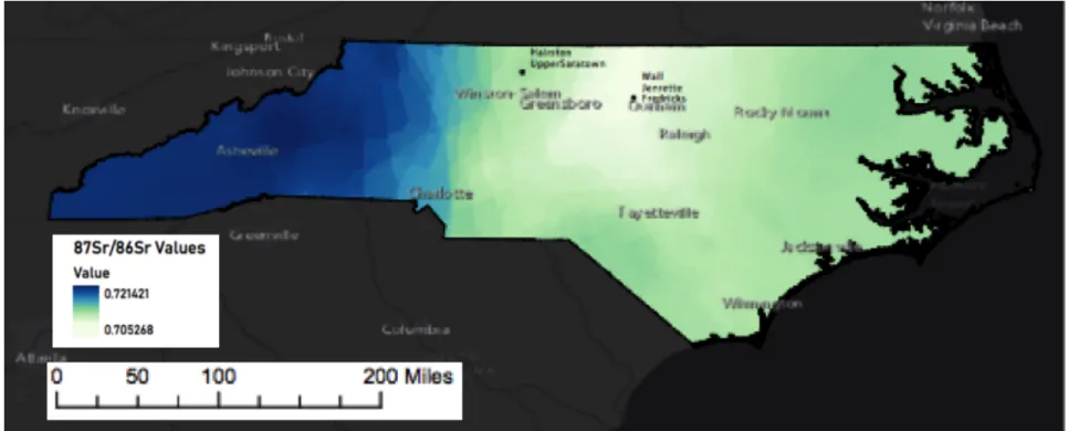
archaeological studies of population mobility due to the demonstrable correlation between the Sr present in the hard tissues of living organisms and the underlying geology of a given locality (Bentley 2006:136, Price et al. 2000:906). Though the isotopic ratios of a given locale result from a mixture of atmospheric sources (primarily rainfall) and weathering of underlying geology, atmospheric contributions are assumed to be minimal in most areas (Bentley 2006:152) and are demonstrably minimal in the Carolinas (Watts et al. 2019:21). Using values derived from well-known geological components and outcrops, an expected strontium isoscape, or isotope landscape, can be constructed. This isoscape base-map can be used to identify the general geological provenience of archaeological samples. In the context of North Carolina, geological patterns characterized by the presence of very old rocks in the west and generally younger strata to the east result in a situation where strontium values can readily distinguish between the major geologic zones, including the coastal plain, Piedmont and Blue Ridge mountains in the west.
2006:137). Because 87Sr is produced over time as a product of decay, the relationship between the amount of radiogenic 87Sr, relative to non-radiogenic 86Sr, is dependent on the ratio of Rb/Sr in a given geological formation and the age of the rock itself (Bentley 2006:137). Thus, in general, rocks with high Rb/Sr, and old rocks will have high 87Sr/86Sr relative to rocks with low Rb/Sr and young rocks (Bentley 2006:137). An important exception to this generalization is oceanic sedimentary rock that reflects the averaged 87Sr/86Sr from millennia of continental weathering (Bentley 2006:139). Because these sedimentary rocks have very low Rb/Sr, they preserve these ratios, independent of age. The weathering of rocks enriches the soil and water with a locally characteristic ratio of 87Sr/86Sr. This Sr acts as a substitute for calcium (Ca), cycling up the trophic chain and incorporating into hydroxyapatite during the formation of vertebrate hard tissues such as bones and teeth (Bentley 2006:137, Price et al. 2000:906). Unlike lighter isotopes (e.g., C, O and N), Sr does not measurably fractionate during biologic processes, allowing for the comparison of the biological Sr incorporated into bones and teeth to geological sources (Bentley 2006:141, Price et al. 2000:906).
Tooth enamel is the preferred tissue from which to study the isotopic composition of archaeological fauna for two reasons. Unlike bone tissue, which is porous and undergoes remodeling every few months, tooth enamel does not undergo remodeling after initial
The Geological Terranes of North Carolina
Because the 87Sr/86Sr present in tooth enamel is thought to be reflective of the surficial geology of the region in which the specimen lived during tooth formation, it is necessary to understand the geology where the specimens are sampled. North Carolina is divided into three broad physiographic provinces from west to east, the Blue Ridge, the Piedmont and the Coastal Plain (NCDEQ 2019). These physiographic provinces are further subdivided into geological terranes (Figure 4), with 87Sr/86Sr that is reflective of their age and geological composition. The Eno and Dan River sites are situated within the Piedmont terrane, which is composed of rocks with 87Sr/86Sr values ranging from approximately 0.704 to 0.715 (Watts et al. 2019:13-15, Cary 2018:6). The Eno River sites are situated on the Carolina Slate Belt, which is one of the geological provinces that makes up the Piedmont and is composed of metamorphosed igneous rocks that formed approximately 540-630 million years ago (NCDEQ 2019). In the drainages of the Eno River, however, Watts et al. (2019:21) demonstrate that the 87Sr/86Sr values of
groundwater and surface water are dominated by contributions from the much younger (~200 million year) rocks. Groundwater and river water samples from the Neuse and Cape Fear River Basins, particularly at the headwaters of these rivers, both of which are located in the Carolina Slate Belt, suggest that the isotopic composition of this area is influenced by precipitation, granitic rock, and diabase dikes (Watts et al. 2019:21). Deer exploited from the region immediately surrounding the Eno River sites are therefore expected to have 87Sr/86Sr values ranging from 0.7040 to 0.710. In contrast, Sr in surface water from the Dan River sites is
this study may be in-taking Sr from a variety of sources, including surficial and deeper
geological Sr from browse, forbs, and grasses (Fulbright and Ortego-Santos 2013:12), as well as both springs and river water Sr through drinking. Watts et al. (2019:19) demonstrate that there are significant differences between the Sr composition of surficial and deeper bedrock, which may effect the Sr composition of deer, which would be consuming both surficial and river water, as well as deep-rooted vegetation. However, much like the river water samples in Watts et al. (2019), these varied sources can be expected to produce averaged Sr values that fall within the expected local range established using geological and water samples from across North Carolina.
To the east of the Piedmont terrane, the Coastal Plain covers almost half of the state and exposes mainly of marine sedimentary rock dating to the Tertiary and Cretaceous periods. These younger rocks are associated with distinctive 87Sr/86Sr values averaging 0.709 and ranging from 0.708 to 0.713 (Crenshaw 2019; Watts et al. 2019:13-15; Cary 2018:6). The Blue Ridge province borders the Piedmont terrane to the west. The Blue Ridge province is composed of the oldest rocks in the region (>900 million years) and reflects the highest 87Sr/86Sr values in the state, ranging from approximately 0.718 to 0.726 (Cary 2018:6). These geological zones create an overall pattern of intermediate values in the east, low to intermediate values in the Piedmont, and high values to the west.
isotopic landscape, of North Carolina using the available literature (Figure 5; Cary 2018, Crenshaw 2019, Watts et al. 2019).
Sample Selection and Processing
Deer specimens from the Wall, Jenrette, Fredricks, Hairston, and Upper Saratown sites were selected from the collections of the Research Labs of Archaeology at the University of North Carolina at Chapel Hill. Deer teeth were selected based on tooth number, side, and context. Whenever possible, mandibular third molars of the same anatomical side were sampled, in order to avoid unintentional repeated sampling of the same individual. Three mandibular second molars (31OR11.1, 31OR231A.1, and Sk1.2) and one deciduous fourth premolar (31OR11.4) were the exception to this protocol. These teeth were extracted from complete mandibles,
assuring that individuals were not repeatedly sampled. The third molars of these mandibles were determined to be unusable due either to excessive wear or underdevelopment. The anatomical side varied between sites, depending on the prevalence of the mandibular third molar in a given assemblage. For example, all teeth sampled from the Hairston Site (Sk1) were anatomical lefts, whereas all teeth sampled from Upper Saratown (Sk1a) were anatomical rights. Additionally, in order to determine the scale and impact of deer mobility on 87Sr/86Sr values, five individual deer (Individuals 12, 27, 30, 40, and 42) were sampled multiple times using the first, second, and third molars, which develop sequentially in the first year of life. These specimens provide a
measurement of Sr variability within an individual deer’s home range over a period of more than a year. Finally, five rodent specimens were selected to establish site-specific Sr baselines.
Figure 4. Geological Terranes of North Carolina (NCDEQ 2019)
Figure 5. Approximate Sr isoscape of North Carolina based on values drawn from Cary 2018, Crenshaw 2019, and Watts et al. 2019
CHAPTER 5: RESULTS
General Trends in 87Sr/86Sr Composition
Analysis of Sr from deer enamel produced 69 values from 61 individuals. Because of the
distinct Sr compositions of the geological terrains in North Carolina, variation in the third
decimal place is sufficient to establish geological provenience and values discussed here have
been rounded to the fourth decimal place. The 87Sr/86Sr values derived from the deer samples
range from 0.7048 to 0.7217 (Table 2; Figure 6) and clearly reflect multiple geological terranes
(Table 1, Figure 6). Sample derived from multiple teeth in the same mandible (i.e. Individuals 12,
27, 30, 40, and 42) exhibit minimal 87Sr/86Sr variation (Table 2, Figure 6). The 87Sr/86Sr values for sets of molars from these individuals have internal standard deviations ranging from 0.00006
to 0.0003 supporting ethological studies showing that deer inhabit geographically small home
ranges. The Sr data were analyzed in the following sections using histograms and two statistical
tests, Levene’s test for homogeneity of variance and Welch’s ANOVA, the latter of which was
selected because it does not assume equality of variance. For those individuals that were tested
multiple times (Individual 12, 27, 30, 40, and 42), only the third molar was used in statistical
analyses, except in the case of Individual 40. The second molar represents individual 40, due to
the failure of the third molar. Discussion of these values will also focus on the third molar for
these individuals.
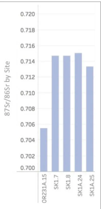
Additionally, analysis of Sr from rodent teeth from the Eno and Dan River assemblages
produced five values that function as site-specific baselines (Table 1, Figure 8). The Eno River
values of 0.7147, 0.7150, and 0.7133. These values match the geological and surface water
samples collected in the areas immediately surrounding the site, which range from 0.7120 to
0.7150 for the Dan River (Crenshaw 2019) and 0.7040 to 0.7100 for the Eno River (Watts et al.
2019:13-15). Although the rodents analyzed in this study were recovered during archaeological
excavation, it is unknown whether they were anthropogenically deposited in antiquity or through
subsequent burrowing. Therefore, the rodent samples are noted to be of unknown chronological
provenience and function only as site-level baselines to be compared to the analyzed deer
specimens and function to confirm that the geology of the sites is consistent with the North
Carolina isoscape derived from geological and hydrological samples (Cary 2018, Crenshaw 2019,
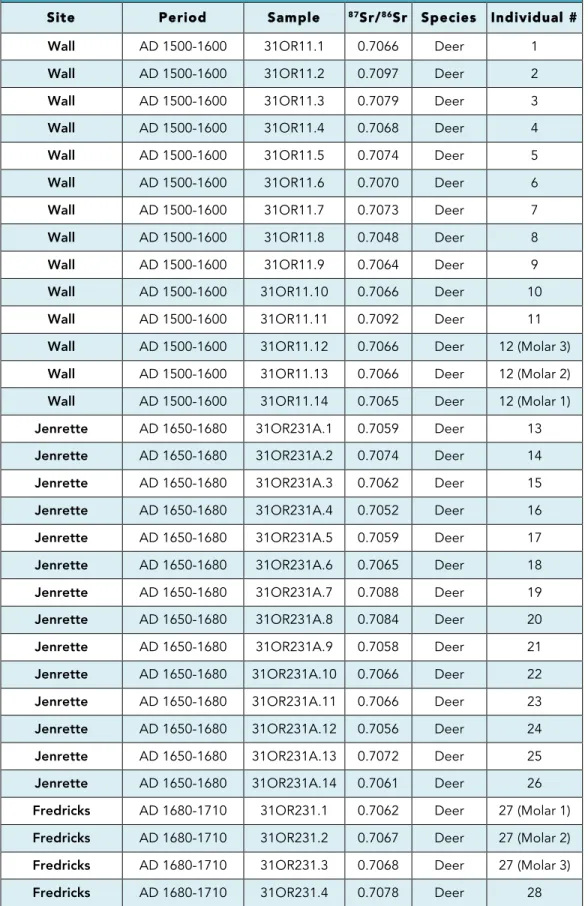
Table 2. 87Sr/86Sr Values from Eno and Dan River Individuals
Site Period Sample 87Sr/86Sr Species Individual #
Wall AD 1500-1600 31OR11.1 0.7066 Deer 1
Wall AD 1500-1600 31OR11.2 0.7097 Deer 2
Wall AD 1500-1600 31OR11.3 0.7079 Deer 3
Wall AD 1500-1600 31OR11.4 0.7068 Deer 4
Wall AD 1500-1600 31OR11.5 0.7074 Deer 5
Wall AD 1500-1600 31OR11.6 0.7070 Deer 6
Wall AD 1500-1600 31OR11.7 0.7073 Deer 7
Wall AD 1500-1600 31OR11.8 0.7048 Deer 8
Wall AD 1500-1600 31OR11.9 0.7064 Deer 9
Wall AD 1500-1600 31OR11.10 0.7066 Deer 10
Wall AD 1500-1600 31OR11.11 0.7092 Deer 11
Fredricks AD 1680-1710 31OR231.5 0.7068 Deer 29 Fredricks AD 1680-1710 31OR231.6 0.7078 Deer 30 (Molar 1) Fredricks AD 1680-1710 31OR231.7 0.7075 Deer 30 (Molar 2) Fredricks AD 1680-1710 31OR231.8 0.7072 Deer 30 (Molar 3) Fredricks AD 1680-1710 31OR231.9 0.7081 Deer 31 Fredricks AD 1680-1710 31OR231.10 0.7061 Deer 32 Fredricks AD 1680-1710 31OR231.11 0.7080 Deer 33 Fredricks AD 1680-1710 31OR231.12 0.7064 Deer 34 Fredricks AD 1680-1710 31OR231.13 0.7073 Deer 35 Fredricks AD 1680-1710 31OR231.14 0.7069 Deer 36
Hairston AD 1450-1620 SK1.1 0.7161 Deer 37
Hairston AD 1450-1620 SK1.2 0.7173 Deer 38
Hairston AD 1450-1620 SK1.3 0.7161 Deer 39
Upper Saratown AD 1670-1710 SK1A.20 0.7158 Deer 58 Upper Saratown AD 1670-1710 SK1A.21 0.7095 Deer 59 Upper Saratown AD 1670-1710 SK1A.22 0.7082 Deer 60 Upper Saratown AD 1670-1710 SK1A.23 0.7150 Deer 61 Jenrette Unknown 31OR231A.15 0.7055 Rodent 62
Hairston Unknown SK1.7 0.7147 Rodent 63
Hairston Unknown SK1.8 0.7147 Rodent 64
Upper Saratown Unknown SK1A.24 0.7150 Rodent 65
Figure 6. 87Sr/86Sr values of deer samples from the Eno and Dan River sites with baseline Sr values covering an area of 35km2 (Baseline Sr values based on Cary 2018, Watts et al. 2019, Crenshaw 2019; logistical mobility distance value of 35km2 drawn from average highest logical mobility values of North American hunter-gatherer communities referenced
in Kelly 1983:298)
87Sr/86Sr Compositions of Eno River Individuals
The 87Sr/86Sr baseline of the Wall, Jenrette, and Fredricks sites, based on 1 rodent sample,
is measured at 0.7055 (Table 2). This is consistent with groundwater and surface water samples
from the Eno River Basin, which range from 0.704 to 0.710 (Watts et al. 2018:13-15). Deer
analyzed from the Eno River sites have 87Sr/86Sr values ranging from 0.7048 to 0.7097 and thus
all fall within the range of variation expected within the Neuse and Cape Fear River Basins that
surround the Eno River (Table 2). Most of the Sr values cluster between 0.7061 to 0.7080
(Figure 6; Figure 9), particularly during the Precontact Wall and the Late Contact Fredricks sites,
but this pattern is also noticeable for the Jenrette site suggesting that most deer were harvested
from a limited geographic area.
Twelve individuals were sampled from the Wall site, with 87Sr/86Sr values ranging from
0.7048 to 0.7097 (Table 2, Figure 6). The majority of the Sr values cluster between 0.7064 and
0.7079, while three individuals fall outside of this range, measuring 0.7048, 0.7093, and 0.7097,
respectively (Figure 6). Fourteen individuals were sampled from the Jenrette site, with 87Sr/86Sr
values ranging from 0.7052 to 0.7088 (Figure 6). When compared to the Wall site individuals,
the Jenrette individuals exhibit a slightly smaller range of Sr values. Ten individuals were
sampled from the Fredricks site, with 87Sr/86Sr ranging from 0.7061 to 0.7080 (Figure 6).
87Sr/86Sr values from the Fredricks site deer cluster even more tightly than those of either of the
previous two settlements.
The Sr values of individual deer were analyzed using several statistical tests. Histograms
visually indicate three patterns at the Wall, Jenrette, and Fredricks sites (Figure 9). At the Wall
site, the data form three distinct clusters. At the Jenrette site, the data form two clusters. At the
homogeneity of variance confirms that the sample populations have equal variance at a
significance level of 0.05 (p=0.41), while Welch’s ANOVA also indicates that the populations
87Sr/86Sr Values of Dan River Individuals
The 87Sr/86Sr baseline of the Hairston and Upper Saratown sites, based on four rodent
samples, ranges between 0.7133 to 0.7150, which is consistent with geological samples from the
Dan River Basin, which range from 0.7128 to 0.7150 (Crenshaw 2019). The Dan River deer
have 87Sr/86Sr values ranging from 0.7081 to 0.7217 (Table 2; Figure 6). Most of the values
cluster between 0.7123 and 0.7174 (Figure 11), which is consistent with the geological terranes
within a 35km radius (Crenshaw 2019) and the rodent samples analyzed in this study.
Four individuals were sampled from the Hairston site, with 87Sr/86Sr values ranging from
0.7160 to 0.7173 (Table 2; Figure 6). The individuals analyzed from Upper Saratown are divided
into two phases based on occupation period. Individuals from both periods display a wider range
of values than those from the Hairston site. The six individuals sampled from the Middle Contact
Period have 87Sr/86Sr values ranging from 0.70960 to 0.7174, while the thirteen individuals
sampled from the Late Contact Period have an even wider range extending from 0.7082 to
0.7217 (Table 2; Figure 6). The range of values from the Late Contact Period of the Upper
Saratown site is noticeably larger than that of both the Middle Contact Period at Upper Saratown
and the Hairston site.
Histograms visually indicate three modes at the Dan River sites (Figure 10). At the
Hairston site, where the sample size is only four individuals, values form a single cluster. At the
Middle Contact Period of the Upper Saratown site, values form two clusters, the first of which is
consistent with the cluster formed by the Hairston site data. Finally, at the Late Contact Period of
the Upper Saratown site, the data exhibit the largest spread of any site in this study and form four
clusters. Levene’s test for homogeneity of variance indicates that there is equal variance across
suggests that the populations are not statistically different at a significance level of 0.05 (p=0.14).
However, these results are impacted by the small sample sizes of the Hairston and Middle
Comparison of Eno and Dan River Individuals
Visually, the histograms indicate two distinct patterns at the Eno and Dan River sites
(Figure 11). Whereas Eno River individuals form a single cluster, Dan River individuals form
three distinct clusters. Additionally, 1 of the Dan River clusters overlaps with the Eno River Sr
values. The histograms visually emphasize that the variance is much higher amongst the Dan
River individuals, than amongst those of the Eno River. Levene’s test for homogeneity of
variance also indicates that the variances of all individuals from the Eno and Dan River sites are
statistically different at a significance level of 0.05 (p=0.000026). Furthermore, Welch’s
ANOVA test indicates that the differences between the Eno and Dan River samples are
statistically significant at a significance level of 0.05 (p<0.001), confirming the visual patterns
suggested by the histograms. Finally, Welch’s ANOVA indicates that all populations of the same
period are statistically different at a significance level of 0.05 (Table 3), while Levene’s test for
homogeneity of variance is slightly more ambiguous between sites of the same period (Table 4).
According to Levene’s test, only the populations of the Jenrette and Middle Contact Upper
Saratown sites are statistically different at a confidence level of 0.05 (p = 0.0036), while
comparison of the Wall and Fredricks sites to the Hairston and Late Contact Upper Saratown
sites, respectively, produce p-values indicating that these populations are not statistically
Figure 11. Histograms of 87Sr/86Sr Values from the Eno and Dan River
Table 3. Levene's Test p-values: Contemporary Sites
Wall
(Precontact) (Middle Contact) Jenrette (Late Contact) Fredricks Hairston
(Precontact) 0.35 - -
Upper Saratown
(Middle Contact) - 0.0036 -
Upper Saratown
(Late Contact) - - 0.053
Table 4. Welch's t-test p-values: Contemporary Sites
Wall
(Precontact) (Middle Contact) Jenrette (Late Contact) Fredricks Hairston
(Precontact) 2.06x10⁻⁹ - -
Upper Saratown
(Middle Contact) - 0.000011 -
Upper Saratown
CHAPTER 6: DISCUSSION
General Trends
The Sr data produced in this study indicate three general trends in regards to deer
exploitation and settlement provisioning within the Eno and Dan River drainages. Firstly, the
five deer individuals that were sampled multiple times exhibit internal standard deviations that
are less than the analytical uncertainty, ranging between 0.00006 and 0.0003 for a given
individual, confirming ecological models of deer home ranges. These data confirm the assertion
that the variation in 87Sr/86Sr between different individual deer is the result of habitation in
different geological terranes, rather than extensive movements by individual deer. This confirms
that analysis of deer tooth enamel is an effective way to identify the exploitation territories used
by Native hunters and suggests that variation in Sr values in deer teeth is not driven by migratory
behavior.
Secondly, the Sr values generated by this study clearly correlate to predictable values
from geological terranes in the regions surrounding the Eno and Dan River drainages. This
demonstrates the strength of the method, which generated Sr values of clearly identifiable
geological provenience from surrounding geological terranes. Because these values are drawn
only from those individuals that were recovered from the village sites themselves, they
specifically represent those deer that were exploited in order to provision the settlement and
provide a conservative estimate of the territories regularly exploited by Native communities in
the Eno and Dan River drainages.
the Eno and Dan River individuals are statistically different when viewed as two distinct
assemblages, with a highly significant p-value of 0.000026. This is visually evident in the
histograms of each site (Figure 11), where the values form distinct patterns and the distributions
are visually different, with the Dan River individuals exhibiting a much wider range. The Dan
River individuals were likely procured from three distinct geological zones, as evidenced by the
clustering visible in the histogram and comparisons to geological samples (Figure 11; Crenshaw
2019), while the Eno River individuals appear to have been procured from a single geological
zone (Figure 11; Watts et al. 2019). These trends demonstrate not only that Eno and Dan River
communities exploited different hunting territories from one another, as would be expected given
the distance between the communities (approx. 96 km), but also that the hunting strategies of
Native Piedmont communities were regionally specific (Figure 12).
Diachronic Trends from the Eno River
The Sr values from the Eno River individuals suggest that the Native communities
occupying the Wall, Jenrette, and Fredricks sites all exploited locally available deer, with Sr
values ranging between 0.7048 to 0.7097 (Table 2). These data fall within the expected range of
values for the Eno River Basin and the area immediately surrounding it, which range from 0.704
to 0.710 (Watts et al. 2019). These data also match the Sr value of the archaeological rodent
sampled from the Jenrette site in this study, which measured 0.7055.
87Sr/86Sr values from the Wall site individuals are consistent with local exploitation,
though the range of 0.7048 to 0.7097 (Table 2, Figure 6) is slightly larger than the ranges of Sr
values from subsequent settlements. This may indicate that the Precontact Wall site community
have been exploited within this general region. 87Sr/86Sr values from the Jenrette site individuals
show a similar pattern, with values ranging from 0.7052 to 0.7088 (Figure 6), while graphical
representations of the data illustrate a slight shift towards lower values during this period (Figure
9). These data indicate the continued exploitation of local deer from the adjacent Basins, while
possibly indicating an increased focus on a particular local hunting area. 87Sr/86Sr values from the
Fredricks site individuals, however, range from 0.7061 to 0.7080 and show a distribution more
similar to that for the Wall site than Jenrette (Table 2, Figure 6). Additionally, none of the deer
from the Fredricks site have Sr values lower than 0.706, again suggesting a focus on a particular
hunting territory in the region. These values may suggest that the community at the Fredricks site
was not exploiting environments around the headwaters of the Neuse River, where 87Sr/86Sr
values trend between 0.7040 and 0.7060 (Watts et al. 2019:13-15). Rather, this range of values
suggests that hunters from the Fredricks site were focusing on environments to the southeast of
the headwaters. This slight difference in exploitation zone makes sense given that the inhabitants
of the Fredricks site are believed to be newcomers to the area and probably were not continuing
an exploitation tradition consistent with those of the inhabitants of the Wall and Jenrette sites.
Overall, the 87Sr/86Sr values from individuals recovered from all three Eno River sites are
remarkably consistent with one another, suggesting that deer exploitation practices remained
fairly uniform across all three periods, with subtle shifts in hunting territories between periods.
These data indicate that both Pre- and Post-Contact communities exploited environments located
in the Neuse and Cape Fear River Basins. Minimum zones of exploitation for each site are
visually represented in Figure 13, highlighting both the consistency of hunting territories across
Diachronic Trends from the Dan River
The Dan River individuals exhibit much more variation than those from the Eno River
sites, with values ranging from 0.7081 to 0.7217, which correspond to the archaeological rodent
samples from the Hairston and Upper Saratown sites, which range from 0.713 to 0.715 (Table 2;
Figure 6). Though the majority of the deer values fall within the expected range for the Dan
River Basin and the area immediately surrounding it, which ranges from 0.712 to 0.718
(Crenshaw 2019), six individuals have Sr values that are inconsistent with local exploitation.
This is further evidenced by the archaeological rodent samples from the Hairston and Upper
Saratown sites, which range from 0.713 to 0.715 (Table 2). Four of the outliers match the Sr
value of the archaeological rodent sampled from the Jenrette site in this study, which measured
0.7055, while the remaining two measure 0.720 and above (Table 2; Figure 6).
Like their Precontact counterparts at the Wall site, the 87Sr/86Sr values from the Hairston
individuals are consistent with local exploitation, ranging from 0.7158 to 0.7173 (Table 2, Figure
6). However, the sample size is small due to assemblage limitations, including only four
individuals. While this pattern of local exploitation continues during the Middle Contact Period
of the Upper Saratown site, with most values ranging from 0.7148 to 0.7174, one individual has
a non-local value of 0.7096 (Table 2, Figure 6). This value likely corresponds to the Neuse or
Cape Fear River Basin to the east, and potentially overlaps with areas used by the Eno River
communities. It also suggests an eastward territorial expansion into new hunting territories. This
trend continues in the Late Contact Period occupation of the Upper Saratown site, when most
values fall within the local range between 0.7128 and 0.7165, but five individuals fall outside of
this expected local range (Table 2, Figure 6; Crenshaw 2019). Three of these individuals also