Proposed Highfield Subdivision Development.
By Craig Davison
Craig Davison completed his Bachelor of Environmental Management and Planning in June 2012. Craig has now relocated to Melbourne Australia to pursue a career in environmental management and sustainability.
Background:
The recent earthquakes in Canterbury have left thousands of Christchurch residents’ homeless or facing the possibility of homelessness. The New Zealand Government, so far, have announced that 5,100 homes in Christchurch will have to be abandoned as a result of earthquake damaged land (Christchurch City Council, 2011). They have been zoned red on the Canterbury Earthquake Recovery Authority (CERA) map and there are another 10,000 that have been zoned orange, awaiting a decision (Christchurch City Council, 2011). This situation has placed pressures on land developers and local authorities to speed up the process associated with the development of proposed subdivisions in Christchurch to accommodate residents in this situation (Tarrant, 2011).
Highfield Park:
The proposed Highfield Park subdivision is one of more than 15 new subdivisions in Christchurch and surrounding areas including Prebbleton, Lincoln and Marshlands (McDonald, 2011). The developers, Highfield Park Limited, have identified a site known as the Mills Hills block for the development and have the option of purchasing 90 percent of the land from its 15 individual owners (McDonald, 2011). The land in question is larger than Hagley Park comprising a 180 hectare semi-rural block located to the north of central Christchurch. It borders Redwood to the west, Hills and Hawkins Roads to the east, the Styx River to the north and Queen Elizabeth Drive to the South (McDonald, 2011). The site comprises elevated land that has been zoned green on the Canterbury Earthquake Recovery Authority map (Highfield Park, 2011). There has been no occurrence of liquefaction from the recent earthquakes in Canterbury at this site and the land will be engineered prior to the building of houses with the most up to date compaction and fill techniques (Highfield Park, 2011).
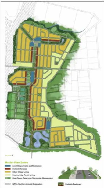
It has been confirmed that there is enough potential land for development in Christchurch to provide up to 6,000 homes (Christchurch City Council, 2011) and Highfield Park, would account for 2,400 of this. The developers are optimistic and are expecting the first packages to be available within the next 12 – 18 months (Highfield Park, 2011). The Highfield Park plan (Figure 1) will include a diverse range of housing, and offer a variety of living options that are designed to cater for different market requirements. The design includes a mixture of housing densities, a retirement village, open space, including central reserve with a swale and ponds to manage storm water, and four commercial areas including shops, cafes or childcare centres (Highfield Park, 2011). Prices would start from $275, 000 to $1,000,000 plus.
Planning Issues Surrounding Highfield Park Development:
The proposed Highfield Park development, if approved, would require the extension of the boundaries within Christchurch’s urban development strategy, The Greater Christchurch Urban Development Strategy, and the Proposed Change 1 to the Canterbury Regional Policy
Statement (McDonald, 2011) because Mills-Hills
block/Highfield is located outside the present urban growth boundary (Figure 2). The prospect of the subdivision has also met with opposition from the residents and community in the surrounding proximity of the development site (McDonald, 2011).
Main Issue – Urban Growth Boundaries:
The Greater Christchurch Urban Development Strategy 2007:
In 2007, Environment Canterbury, Christchurch City Council, Selwyn District Council, Waimakariri District Council and the NZ Transport Agency produced The Greater Christchurch Urban Development Strategy (Tarrant, 2011). It is an approach to growth management with an emphasis on transportation and land use planning (Environment Canterbury, 2007). It is an attempt to address the problems that are caused while Christchurch and greater Christchurch continue to develop and expand. Its purpose is to manage the growth that is expected in the region by 2041 sustainably (Environment Canterbury, 2007). The Strategy has a vision for Greater Christchurch to have enhanced lifestyles, enhanced environments, prosperous economies, managed growth and
integrated and collaborative leadership (Environment Canterbury, 2007).
Canterbury Regional Policy Statement Proposed Change 1 (Urban Development Strategy):
The Proposed Change 1 of the Canterbury Regional Policy Statement provides statutory backing to the Greater Christchurch Urban Development Strategy 2007, but it is not yet operative (Environment Canterbury, 2008). It addresses land use and urban growth management in Greater Christchurch for the next 35 years and sets urban growth boundaries to enforce the Strategy (Tarrant, 2011). The Change has been met with appeals and opposition from developers who are seeking to include additional land within the Urban Development Strategy’s urban limits (Environment Canterbury,
2011). Highfield Park Limited has appealed mainly on the basis of the timing that the development in certain areas can occur. Highfield Park is seeking to have land reclassified as residential within the regions urban boundaries (Environment Canterbury, 2011).
Prior to the series of devastating earthquakes that Canterbury has experienced, Environment Canterbury,
Christchurch City Council and other councils in the region, were against the idea of pushing out the urban limits within the strategy to allow for additional subdivision developments (Environment Canterbury, 2011). Environment Canterbury has made a request to the Environment Court to approve extending the boundaries that are specified presently that restrict new housing development sites to provide additional land for potential developments (Tarrant, 2011). The outcomes will be incorporated into the Canterbury Regional Policy Statement as Chapter 12A, Development of Greater Christchurch (Environment Canterbury, 2010). The chapter will provide statutory Resource Management Act 1991 backing for the Greater Christchurch Urban Development Strategy. If the consent is granted, it would extend the boundaries allowing Highfield Park to be developed, as well as additional sub-divisions such as Prestons, which is a planned development with 2700 sections in Marshland close to Highfield Park (Tarrant, 2011).
Other Issues:
Opposition From Surrounding Community:
The current residents who live in the semi-rural area are concerned that their relaxed lifestyle will be ruined if the planned Highfield subdivision goes ahead (McDonald, 2011). The development would leave rural residents without the right to have farm animals and other rural benefits. The rezoning would apply to the whole area (McDonald, 2011) and would have implications for local residents who own land within the subdivision land and have no intentions of selling it. They are concerned that the development would increase rates, traffic, and noise and create overcrowding in the area (McDonald, 2011). The development would change the nature of the area, as it essentially means
Conclusion:
The Canterbury region has experienced an unexpected series of events which has created
an unprecedented demand for additional land and housing developments in Christchurch.
This raises some questions about local authorities’ degree of readiness for such events with
the Greater Christchurch Urban Development Strategy highlighting some interesting
tensions associated with strategic planning and disasters. The strategy is based on
pre-earthquake collaborative work that identified suitable areas for future development,
according to known risks, population projects and the like. Importantly, however, the UDS
was not intended to be rolled out so rapidly and with so little regard for the inner city
development (which was assumed to be similar). Given all the work and research that went
into the UDS, it is difficult to imagine developing such a strategy in the chaotic aftermath of
a disaster when time and resources are stretched. Yet many of the assumptions underlying
the formation of the strategy no longer apply. Further, there is a lack of co-ordination
between inner city re-development plans and suburban growth. Thus, despite the focus of
the UDS of managed growth, ironically, we may end up with a hollow centre and a suburban
landscape of developments like Highfield Park driving the sprawl the UDS was designed to
combat. The alternative of no or slow growth is equally unpalatable given the unprecedented demand for housing following the quakes. The lesson here is to consider this tension between strategy and flexibility in our plans.References:
Christchurch City Council. (2011, June 24). Sufficient Property to Meet Demand in Christchurch. Scoop. Retrieved From:
Environment Canterbury. (2011, June 23). Court Considers Revising Greater Christchurch Urban Limit. Environment Canterbury Media Statement. Retrieved From: Environment Canterbury (2008). RPS-PC1-Variation 1-PART 2-Maps. Retrieved from
http://ecan.govt.nz/publications/Plans/Variation1PART2Maps.pdf
Environment Canterbury. (2010). Regional Policy Statement: Proposed Change 1 Decisions Relating to Urban Development in Greater Christchurch. Environment Canterbury Media Statement. Retrieved From: http://ecan.govt.nz/publications/Plans/rps-pc-1-newsletter-000210.pdf Environment Canterbury. (2007). Regional Policy Statement: Proposed Change No.1 - Chapter 12A,
Development of Greater Christchurch; and Section 32 Report. Christchurch, New Zealand.
Environment Canterbury. & Christchurch City Council. & Selwyn District Council. & Waimakariri District Council. & New Zealand Transport Agency. (2007). The Greater Christchurch Urban
Development Strategy. Christchurch, New Zealand
Highfield Park. (2011). Highfield – Your Home Your Life. Retrieved From:
McDonald, L. (2011, July 07). Residents Fear Loss of Lifestyle. The Press. Retrieved From:
McDonald, L. (2011, June 18). Proposal for 2400 Houses in Christchurch. The Press. Retrieved From:
McDonald, L. (2001, June 25). Pressure on to Develop Christchurch Land. The Press. Retrieved From:
Tarrant, A. (2011, June 23). Environment Canterbury Looks to Release Land on Christchurch Fringes for up to 5000 Homes; Up to Environment Court. Interest. Retrieved From: