R
EPORT ON
E
XISTING
D
ATA AND
D
ATA
G
APS
D4.1
Reference: INFORM_D4.1_v1.0
Author(s): Peter HUNTER (U STIRLING), Evangelos SPYRAKOS (U STIRLING), Ils REUSEN (VITO), Els KNAEPS (VITO), Mariano BRESCIANI (CNR), Claudia GIARDINO (CNR), Thomas HEEGE (EOMAP), Karin SCHENK (EOMAP), Mátyás PRÉSING (MTA OK), Miguel DIONISIO PIRES (Deltares), and Damien BOUFFARD (EPFL)
Version: 1.0 Date: 22/12/2014
D4.1
Improved Monitoring and Forecasting of Ecological Status of European Inland Waters by Combining Future Earth Observation Data and
Models
Grant Agreement no: 606865
INFORM_D4.1_v1.0 D4.1 Page 2 of 48
D
OCUMENT
C
ONTROL
SIGNATURES
Author(s) : Peter HUNTER (U STIRLING), Evangelos SPYRAKOS (U STIRLING), Ils REUSEN (VITO), Els KNAEPS (VITO), Mariano BRESCIANI (CNR), Claudia GIARDINO (CNR), Thomas HEEGE (EOMAP), Karin SCHENK (EOMAP), Mátyás PRÉSING (MTA OK), Miguel DIONISIO PIRES (Deltares), and Damien BOUFFARD (EPFL)
Reviewer(s) : Peter HUNTER (U STIRLING), Ils REUSEN (VITO)
Approver(s) : Peter HUNTER (U STIRLING), Ils REUSEN (VITO)
CHANGE RECORD
Release Date Pages Description Editor(s)/Reviewer(s)
1.0 22/12/2014 48 For submission to REA Peter HUNTER, Ils
D4.1
Improved Monitoring and Forecasting of Ecological Status of European Inland Waters by Combining Future Earth Observation Data and
Models Grant Agreement no: 606865 INFORM_D4.1_v1.0 D4.1 Page 3 of 48
T
ABLE OF
C
ONTENT
LIST OF FIGURES... 5
LIST OF TABLES ... 6
ACRONYMS & GLOSSARY ... 8
EXECUTIVE SUMMARY ... 11
1. Introduction ... 12
2. Lake Balaton and Kis-Balaton ... 14
2.1. Site description ... 14 2.2. Monitoring data ... 14 2.3. Campaign data ... 15 3. Curonian lagoon ... 17 3.1. Site description ... 17 3.2. Monitoring data ... 17 3.3. Campaign data ... 17 4. Mantua Lakes ... 20 4.1. Site description ... 20 4.2. Monitoring data ... 20 4.3. Campaign data ... 20 5. Venice lagoon ... 23 5.1. Site description ... 23 5.2. Monitoring data ... 23 5.3. Campaign data ... 23 6. Lake Constance ... 26 6.1. Site description ... 26 6.2. Available data ... 26 7. Gironde River ... 28 7.1. Site description ... 28 7.2. Monitoring ... 28 7.3. Campaigns ... 28 8. Scheldt River ... 30 8.1. Site description ... 30 8.2. Monitoring ... 30 8.3. Campaigns ... 30 9. Esthwaite Water ... 32 9.1. Site description ... 32 9.2. Monitoring data ... 32 9.3. Campaign data ... 32 10. Loch Leven ... 34 10.1.Site description ... 34 10.2.Monitoring data ... 34 10.3.Campaign data ... 34 11. IJsselmeer ... 36 11.1.Site description ... 36 11.2.Monitoring data ... 36 11.3.Campaign description ... 36
D4.1
Improved Monitoring and Forecasting of Ecological Status of European Inland Waters by Combining Future Earth Observation Data and
Models Grant Agreement no: 606865 INFORM_D4.1_v1.0 D4.1 Page 4 of 48 12. Lake Geneva ... 37 12.1.Site description ... 37 12.2.Monitoring data ... 37 12.3.Campaign data ... 37 13. LIMNADES ... 39 14. Gap analysis ... 40 15. Conclusion ... 44 Annex 1 ... 45
D4.1
Improved Monitoring and Forecasting of Ecological Status of European Inland Waters by Combining Future Earth Observation Data and
Models
Grant Agreement no: 606865
INFORM_D4.1_v1.0 D4.1 Page 5 of 48
L
IST OF
F
IGURES
Figure 1. The location of the INFORM European study sites. ... 13 Figure 2. Geographic distribution of datasets contributed to LIMNADES. ... 39
D4.1
Improved Monitoring and Forecasting of Ecological Status of European Inland Waters by Combining Future Earth Observation Data and
Models
Grant Agreement no: 606865
INFORM_D4.1_v1.0 D4.1 Page 6 of 48
L
IST OF
T
ABLES
Table 1. Overview of INFORM sites with their main characteristics. †Lake Geneva was added to the INFORM sites after discussions at the INFORM End-User Advisory Board meeting (EUAB01), Venice, March 2014. ... 12 Table 2. Overview of data collected at Lake Balaton and Kis-Balaton in 2010 available to the INFORM project for use in WP5 and WP6. ... 15 Table 3. Overview of data collected at Lake Balaton in 2013 available to the INFORM project for use in WP5 and WP6. ... 16 Table 4. Overview of data collected in the Curonian Lagoon in 2009 available to the INFORM project for use in WP5 and WP6. ... 18 Table 5. Overview of data collected in the Curonian Lagoon in 2011 available to the INFORM project for use in WP5 and WP6. ... 18 Table 6. Overview of data collected in the Curonian Lagoon in 2012 available to the INFORM project for use in WP5 and WP6. ... 19 Table 7.Overview of data collected at Mantua lakes in 2007 available to the INFORM project for use in WP5 and WP6. ... 21 Table 8. Overview of data collected at Mantua lakes in 2011 available to the INFORM project for use in WP5 and WP6. ... 21 Table 9. Overview of other data collected at Mantua Lakes available to the INFORM project for use in WP5 and WP6. ... 22 Table 10. Overview of data collected at Venice Lagoon in 2005 available to the INFORM project for use in WP5 and WP6. ... 24 Table 11. Overview of data collected at Venice Lagoon for seagrass spectral characterization available to the INFORM project for use in WP5 and WP6... 24 Table 12. Overview of data collected at Venice Lagoon in 2011-2012 available to the INFORM project for use in WP5 and WP6. ... 25 Table 13. Overview existing and to be used data for Lake Constance available to the INFORM project for use in WP5 and WP6. ... 26 Table 14. Overview of data collected at Gironde River in 2012 for use in WP5, Task 5.3 (*denotes data only available for use by other INFORM partners after approval by the host organization). ... 28 Table 15. Overview of data collected at Gironde River in 2013 for use in WP5, Task 5.3 (*denotes data only available for use by other INFORM partners after approval by the host organization). ... 29 Table 16. Overview of data collected at Scheldt river in 2010 for use in WP5, Task 5.3 3 (*denotes data only available for use by other INFORM partners after approval by the host organization). ... 31 Table 17.Overview of data collected at Scheldt river in 2012 for use in WP5, Task 5.3 3 (*denotes data only available for use by other INFORM partners after approval by the host organization). ... 31 Table 18. Overview of data collected at Esthwaite Water in 2007 available to the INFORM project for use in WP5 and WP6. ... 32 Table 19.Overview of data collected at Loch Leven in 2007 available to the INFORM project for use in WP5 and WP6. ... 34 Table 20.Overview of data collected at Lake Geneva available to the INFORM project for use in WP5 and WP6. ... 37
D4.1
Improved Monitoring and Forecasting of Ecological Status of European Inland Waters by Combining Future Earth Observation Data and
Models
Grant Agreement no: 606865
INFORM_D4.1_v1.0 D4.1 Page 7 of 48
Table 21. Summary of the existing data available to the INFORM project. (NS = not specified; BGC = biogeochemical data). ... 42
D4.1
Improved Monitoring and Forecasting of Ecological Status of European Inland Waters by Combining Future Earth Observation Data and
Models
Grant Agreement no: 606865
INFORM_D4.1_v1.0 D4.1 Page 8 of 48
A
CRONYMS
&
G
LOSSARY
aCDOM: CDOM absorption coefficient
aNAP: NAP absorption coefficient
ap: Particulate absorption coefficient
aph: Phytoplankton absorption coefficient
at: Total absorption coefficient
AOP: Apparent Optical Properties AOT: Aerosol Optical Thickness APEX: Airborne Prism Experiment ASD: Analytical Spectral Devices BLI: Balaton Limnological Institute bbp: Particulate backscattering coefficient
bp: Particulate scattering coefficient
Chla: Chlorophyll-a
ct: Beam attenuation coefficient
cp: Particulate beam attenuation coefficient
CASI: Compact Airborne Spectrographic Imager CDOM: Coloured Dissolved Organic Matter CEH: UK Centre for Ecology & Hydrology
CHRIS-PROBA: Compact High-Resolution Imaging Spectrometer on Project for On-Board Autonomy satellite CIPEL: Commission Internationale pour la Protection des Eaux du Léman
COD: Chemical Oxygen Demand
CORPI: Klaipeda University Coastal Research and Planning Institute
CNR-IREA: Italian National Research Council - Institute for the Electromagnetic Sensing of the Environment DLS: Department of Life Sciences
DMR: Department of Marine Research DOC: Dissolved Organic Carbon
Eawag: Aquatic Research Institute, Switzerland Ed: Downwelling solar irradiance
ELISA: Enzyme-Linked ImmunoSorbent Assay EOMAP: Aquatic Earth Observation and Mapping EPA: Environmental Protection Agency
EPFL: École Polytechnique Fédérale de Lausanne ESA: European Space Agency
D4.1
Improved Monitoring and Forecasting of Ecological Status of European Inland Waters by Combining Future Earth Observation Data and
Models
Grant Agreement no: 606865
INFORM_D4.1_v1.0 D4.1 Page 9 of 48 EUAB: End-User Advisory Board
EUFAR: European Facility for Airborne Research FR: Full Range
GLaSS: Global Lake Sentinel Services (EU FP7 project) fCDOM: CDOM fluorescence
HH: Handheld
HICO: Hyperspectral Imager for the Coastal Ocean HPLC: High Performance Liquid Chromatography
INFORM: Improved Monitoring and Forecasting of Ecological Status of European Inland Waters by Combining Future Earth Observation Data and Models
ISF: Lake Research Institute of the Environmental Agency Baden-Württemberg IOP: Inherent Optical Properties
JRC: Joint Research Centre
KdKVI: Central Transdanubian (Regional) Inspectorate for Environmental Protection, Nature Conservation and Water Management
KU: Klaipeda University
LiDAR: Light Detection and Ranging
LIMNADES: Lake Bio-optical Measurements and Matchup Data for Remote Sensing LOV: Laboratoire d’Océanographie de Villefranche-sur-Mer
Lu: Upwelling water-leaving radiance
MAGEST: MArel Gironde ESTuary
MERIS: MEdium Resolution Imaging Spectrometer
MIVIS: Multispectral Infrared Visible Imaging Spectrometer MODIS: Moderate Resolution Imaging Spectroradiometer MOSS: Microsoft Office Sharepoint Server
NAP: Non-Algal Particles
NASA: National Aeronautics and Space Administration NERC: UK Natural Environment Research Council
NERC ARSF: UK NERC Airborne Research and Survey Facility OLI: Operational Land Imager
PAR: Photosynthetically Active Radiation PC: Phycocyanin
PE: Phycoerythrin PI: Principal Investigator
PML: Plymouth Marine Laboratory POC: Particulate Organic Carbon
D4.1
Improved Monitoring and Forecasting of Ecological Status of European Inland Waters by Combining Future Earth Observation Data and
Models
Grant Agreement no: 606865
INFORM_D4.1_v1.0 D4.1 Page 10 of 48 Rrs: Remote sensing reflectance
Rw: Water-leaving reflectance SWIR: Short-Wave Infrared TOC: Total Organic Carbon TSM: Total Suspended Matter
UKLEON: United Kingdom Lake Ecological Observatory Network ULM: Ultra Light Motorised
USGS: United States Geological Survey USTIR: University of Stirling
VITO: Flemish Institute for Technological Research VMM: Flemish Environment Agency
VNIR: Visible and Near-InfraRed
D4.1
Improved Monitoring and Forecasting of Ecological Status of European Inland Waters by Combining Future Earth Observation Data and
Models
Grant Agreement no: 606865
INFORM_D4.1_v1.0 D4.1 Page 11 of 48
EXECUTIVE SUMMARY
The INFORM project will develop new or improved inland water quality products for application to the new generation of high spatial and/or spectral resolution satellite sensors and use these products to better parameterize and validate lake ecosystem models. This report documents the existing datasets for algorithm development and validation available to the INFORM project for the European study sites currently considered in the project tasks. The availability of data on the in-situ inherent optical properties (IOPs), apparent optical properties (AOPs), biogeochemical constituents and aerosol optical thickness is catalogued for each study site. In addition, all existing airborne and spaceborne datasets held by INFORM project partner are also listed in full. The availability of each dataset for use by project partners is indicated and contact details for data access are provided. Finally, an analysis of the main data gaps is performed and is provided based on the data needs indicated by INFORM project partners.
D4.1
Improved Monitoring and Forecasting of Ecological Status of European Inland Waters by Combining Future Earth Observation Data and
Models
Grant Agreement no: 606865
INFORM_D4.1_v1.0 D4.1 Page 12 of 48
1.
Introduction
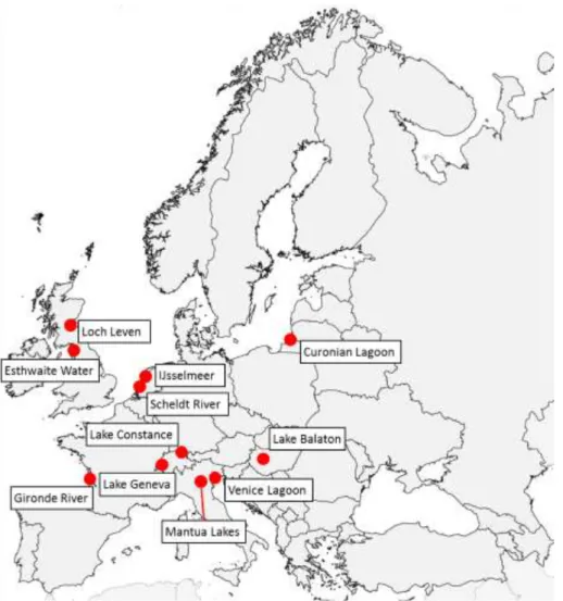
The test sites selected by the INFORM partner institutions for inclusion in the project are listed in Table 1 and shown in Figure 1. The sites encompass a large variety of European inland waters including deep oligotrophic lakes, shallow eutrophic lakes, coastal lagoons and turbid rivers. These specific sites were selected on the basis that they cover a range of optical water types and have very good existing in-situ and remote sensing data (airborne and/or satellite) available to facilitate algorithm development and validation work in INFORM.
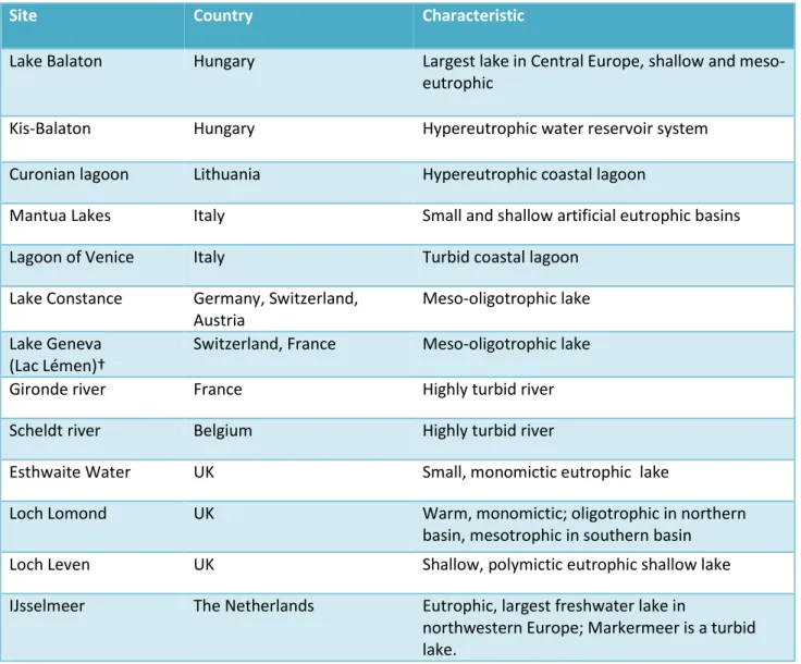
Table 1. Overview of INFORM sites with their main characteristics. †Lake Geneva was added to the INFORM sites after discussions at the INFORM End-User Advisory Board meeting (EUAB01), Venice, March 2014.
Site Country Characteristic
Lake Balaton Hungary Largest lake in Central Europe, shallow and meso-eutrophic
Kis-Balaton Hungary Hypereutrophic water reservoir system
Curonian lagoon Lithuania Hypereutrophic coastal lagoon
Mantua Lakes Italy Small and shallow artificial eutrophic basins
Lagoon of Venice Italy Turbid coastal lagoon
Lake Constance Germany, Switzerland, Austria
Meso-oligotrophic lake Lake Geneva
(Lac Lémen)†
Switzerland, France Meso-oligotrophic lake
Gironde river France Highly turbid river
Scheldt river Belgium Highly turbid river
Esthwaite Water UK Small, monomictic eutrophic lake
Loch Lomond UK Warm, monomictic; oligotrophic in northern
basin, mesotrophic in southern basin
Loch Leven UK Shallow, polymictic eutrophic shallow lake
IJsselmeer The Netherlands Eutrophic, largest freshwater lake in
northwestern Europe; Markermeer is a turbid lake.
D4.1
Improved Monitoring and Forecasting of Ecological Status of European Inland Waters by Combining Future Earth Observation Data and
Models
Grant Agreement no: 606865
INFORM_D4.1_v1.0 D4.1 Page 13 of 48 Figure 1. The location of the INFORM European study sites.
Several INFORM partners acquired data (in-situ and/or airborne hyperspectral and/or spaceborne) prior to the start of the INFORM project. This report provides an overview of the datasets that are available at the INFORM partner organizations for use within the project. Indication is given if the data can be used by other INFORM partners in the framework of the INFORM project. The relevant contact person for data access and for data policy (if available) is also provided for each dataset.
D4.1
Improved Monitoring and Forecasting of Ecological Status of European Inland Waters by Combining Future Earth Observation Data and
Models
Grant Agreement no: 606865
INFORM_D4.1_v1.0 D4.1 Page 14 of 48
2.
Lake Balaton and Kis-Balaton
2.1.
Site description
Lake Balaton is the largest lake in central Europe with a surface area of 592 km2. The lake is very shallow, with a mean depth of approximately 3.3 m and a maximum depth of 25 m. The lake is comprised of four main basins (from west to east): Keszthely; Szigliget; Szemes; and Siofok. The main inlet into the lake is the River Zala in the westernmost part of the Keszthely basin, and the only outlet is through the Siofuk canal in the east. Lake Balaton’s large surface area, allied to its shallow depth, result in it being well mixed and non-stratifiying. During windy periods, intense resuspension of bottom sediments can occur.
The lake has historically suffered from eutrophication due to high inputs of nutrients from agricultural land entering the lake via the River Zala. Until recently, the Keszthely and Szigliget basins were eutrophic with high cyanobacterial biomass during summer months. In comparison, the Siofuk basin has always been more nutrient poor and less productive. Due to recent reductions in the nutrient load the water quality in the western basins has improved considerably and phytoplankton biomass has decreased substantially. The lake also receives high inputs of coloured dissolved organic matter (CDOM) from the River Zala, with very high but localized concentrations in the Keszthely basin.
Kis-Balaton is a large, hypertrophic shallow water reservoir system constructed to the south west of Lake Balaton. The system extends to about 76 km2 encompassing open water (some 28 km2) and wetland habitats. The mean depth of the open water is typically about 1m. The system was constructed to reduce the external loading of nutrients and sediment in Lake Balaton from the River Zala.
2.2.
Monitoring data
Data from long-term monitoring programmes led by the Balaton Limnological Institute (BLI) and the Central Transdanubian (Regional) Inspectorate for Environmental Protection, Nature Conservation and Water Management (KdKVI) are available to the project for WP5 and WP6. The long-term monitoring programmes involve the collection of in-situ measurements and water samples at 4-5 stations on Lake Balaton approximately every fortnight during ice-off conditions. The key parameters measured include (length of record): phytoplankton counts (1965-), Chla (1975-), TSM (c. 2000-), DOC (1995-) and nutrients (c. 2000-). The BLI data are from depth-integrated water samples, whereas the KdKVI data are from surface samples (upper 0.5 m).
Data contact
D4.1
Improved Monitoring and Forecasting of Ecological Status of European Inland Waters by Combining Future Earth Observation Data and
Models
Grant Agreement no: 606865
INFORM_D4.1_v1.0 D4.1 Page 15 of 48
2.3.
Campaign data
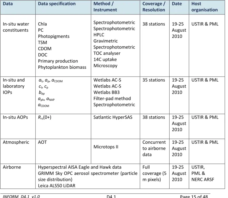
USTIR have undertaken two sampling campaigns in Lake Balaton during August 2010 and 2013 during which airborne hyperspectral data, optical data and in-situ water quality data were collected. These data are also available to the project for WP5 and WP6. These campaigns included measurement of IOPs, AOPs, water constituents concurrent to airborne and satellite overpasses. An overview of these data is provided in Table 2 and Table 3 for the years 2010 and 2013 respectively.
Data contact
Dr Peter Hunter, University of Stirling, [email protected]
Table 2. Overview of data collected at Lake Balaton and Kis-Balaton in 2010 available to the INFORM project for use in WP5 and WP6.
Data Data specification Method / Instrument Coverage / Resolution Date Host organisation In-situ water constituents Chla PC Photopigments TSM CDOM DOC Primary production Phytoplankton biomass Spectrophotometric Spectrophotometric HPLC Gravimetric Spectrophotometric TOC analyser 14C uptake Microscopy 38 stations 19-25 August 2010 USTIR & PML In-situ and laboratory IOPs at, ap, aCDOM ct, cp bbp aph, aNAP aCDOM Wetlabs AC-S Wetlabs AC-S Wetlabs BB3 Filter-pad method Spectrophotometric 35 stations 19-25 August 2010 USTIR & PML
In-situ AOPs Rrs(0+) Satlantic HyperSAS 38 stations 19-25 August 2010
USTIR & PML
Atmospheric AOT
Microtops II Concurrent to airborne data
19-25 August 2010
USTIR & PML
Airborne Hyperspectral AISA Eagle and Hawk data
GRIMM Sky OPC aerosol spectrometer (particle size distribution)
Leica ALS50 LiDAR
Full coverage (5 m pixels) 19-25 August 2010 USTIR, PML & NERC ARSF
D4.1
Improved Monitoring and Forecasting of Ecological Status of European Inland Waters by Combining Future Earth Observation Data and
Models
Grant Agreement no: 606865
INFORM_D4.1_v1.0 D4.1 Page 16 of 48
Spaceborne MERIS FR data 1 image 22
August 2010
USTIR, PML & ESA
Table 3. Overview of data collected at Lake Balaton in 2013 available to the INFORM project for use in WP5 and WP6.
Data Data specification Method / Instrument Coverage / Resolution Date Host organisation In-situ water constituents Chla PC TSM CDOM DOC POC Phytoplankton counts Spectrophotometric Spectrophotometric Gravimetric Spectrophotometric Shimazdu analyser Carlo-Erba analyzer Microscopy 13 stations 10-17 August 2013 USTIR In-situ and laboratory IOPs at, ap, aCDOM ct, cp bbp aph, aNAP aCDOM fCDOM Wetlabs AC-S Wetlabs AC-S Wetlabs BB3 Filter-pad method Spectrophotometric EEM fluometer 13 stations 10-17 August 2013 USTIR
In-situ AOPs Rrs(0+) Satlantic HyperSAS 13 stations 10-17 August 2013
USTIR
Spaceborne Landsat-7 ETM+ 1 image 16
August 2013
D4.1
Improved Monitoring and Forecasting of Ecological Status of European Inland Waters by Combining Future Earth Observation Data and
Models
Grant Agreement no: 606865
INFORM_D4.1_v1.0 D4.1 Page 17 of 48
3.
Curonian lagoon
3.1.
Site description
The Curonian Lagoon is the largest lagoon in Europe, extending over about 1560 km2 between Lithuania and the Russian Federation. It is physically separated from the Baltic Sea by a narrow strip of land called the Curonian Spit but maintains a hydrological connection via the Klaipeda Strait. The northern part of the lagoon is a transitional riverine-like system, while the southern part is lacustrine with limited water exchange and lower current velocities. The Curonian Lagoon is considered to be a freshwater system with an average annual salinity ranging from 2.6% at the inlet connecting it to the sea to 1.2% in the northern part and 0.1% in the central area. The Nemunas River is the main input into the system.
The lagoon is very shallow and readily mixed by wind action, although weak stratification can occur temporarily during the summer. The system is also highly eutrophic due to external nutrient loads received via the Nemunas River. Consequently, the lagoon is highly turbid due to the wind-driven resuspension of bottom sediments in shallow waters and intensive primary production. Diatoms blooms (mainly Stephanodiscus hantzschii) occur in the spring, but are replaced by cyanobacteria during summer months (mainly Aphanizomenon flos-aquae and Microcystis aeruginosa). Macrophytes are largely confined to the littoral zone.
3.2.
Monitoring data
Data from long-term monitoring program led by the Department of Marine Research (DMR) of Environmental Protection Agency of Lithuania (EPA) are available to the project for WP5 and WP6. The existing national monitoring system in the Lithuanian part of the Curonian Lagoon involves the collection of in-situ measurements and water samples at 10-14 stations located in the Klaipeda Strait, within the inner part of the lagoon, and in the mouth of the Nemunas River. Sampling is conducted approximately every month. The key parameters measured include (length of record): meteorological (temperature, wind speed and direction, humidity etc.) and hydrological (water temperature, salinity, currents direction and speed, transparency (Secchi disk depth) and colour, pH (since 1954 – ); dissolved oxygen concentration (since 1961 – ); nutrients (since 1967-1979 – ); phytoplankton species composition, abundance and biomass (since 1980 – ); chlorophyll a concentration (since 1983 – ); TSM (c. since 1999 – ). Samples are taken from the surface (upper 0.5 m).
Data contact
Diana Vaičiūtė, CORPI KU, [email protected].
3.3.
Campaign data
The Coastal Research and Planning Institute (CORPI) of Klaipeda University (KU) together with Optical Remote Sensing Group at CNR-IREA have undertaken several field campaigns in the Curonian Lagoon during
D4.1
Improved Monitoring and Forecasting of Ecological Status of European Inland Waters by Combining Future Earth Observation Data and
Models
Grant Agreement no: 606865
INFORM_D4.1_v1.0 D4.1 Page 18 of 48
spring and summer 2009, summer 2011 and 2012 during which optical data and in-situ water quality data were collected (Table 4,Table 5, and Table 6).
Data contact
Mariano Bresciani, Optical Remote Sensing Group, CNR-IREA, Italy, [email protected], Claudia Giardino, Optical Remote Sensing Group, CNR-IREA, Italy, [email protected] Diana Vaičiūtė, CORPI KU, [email protected].
Table 4. Overview of data collected in the Curonian Lagoon in 2009 available to the INFORM project for use in WP5 and WP6.
Data Data specification Method / Instrument Coverage / Resolution Date Host organisation(s) In-situ water constituents Chla CDOM Phytoplankton counts Phytoplankton groups Spectrophotometric Spectrophotometric Microscopy Fluorescence 27 stations 23-26 March 2009, 22 July 2009 CNR-IREA & CORPI In-situ and laboratory IOPs aph,aNAP aCDOM Filter-pad absorption Spectrophotometric 27 stations 23-26 March 2009, 22 July 2009 CNR-IREA, CORPI
In-situ AOPs Rrs(0+), R(0-) ASD-FR 27 stations 23-26
March 2009, 22 July 2009 CNR-IREA, CORPI
Spaceborne MERIS FR data 2 images 23-26
March, 22 July 2009
CNR-IREA, CORPI, ESA
Table 5. Overview of data collected in the Curonian Lagoon in 2011 available to the INFORM project for use in WP5 and WP6.
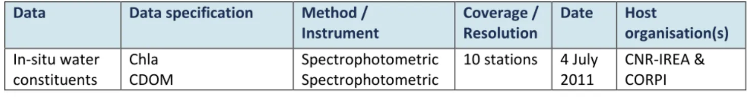
Data Data specification Method / Instrument Coverage / Resolution Date Host organisation(s) In-situ water constituents Chla CDOM Spectrophotometric Spectrophotometric 10 stations 4 July 2011 CNR-IREA & CORPI
D4.1
Improved Monitoring and Forecasting of Ecological Status of European Inland Waters by Combining Future Earth Observation Data and
Models Grant Agreement no: 606865 INFORM_D4.1_v1.0 D4.1 Page 19 of 48 Phytoplankton counts Phytoplankton groups Microscopy Fluorescence In-situ and laboratory IOPs aph,aNAP aCDOM Filter-pad absorption Spectrophotometric 10 stations 4 July 2011 CNR-IREA, CORPI
In-situ AOPs Rrs(0-), R(0-) ASD-FR 10 stations 4 July
2011
CNR-IREA, CORPI
Table 6. Overview of data collected in the Curonian Lagoon in 2012 available to the INFORM project for use in WP5 and WP6.
Data Data specification Method / Instrument Coverage / Resolution Date Host organisation(s) In-situ water constituents Chla CDOM Phytoplankton counts Phytoplankton groups Spectrophotometric Spectrophotometric Microscopy Fluorescence 7 stations 29-30 July 2012 CNR-IREA & CORPI In-situ and laboratory IOPs aph,aNAP aCDOM bbp Filter-pad absorption Spectrophotometric HOBI Labs Hydroscat-6 7 stations 29-30 July 2012 CNR-IREA & CORPI In-situ AOPs Rrs(0+), R(0-) Rrs(0+) ASD-FR WISP-3 7 stations 29-30 July 2012 CNR-IREA & CORPI
Spaceborne CHRIS-PROBA 1 image 3
August 2012
D4.1
Improved Monitoring and Forecasting of Ecological Status of European Inland Waters by Combining Future Earth Observation Data and
Models
Grant Agreement no: 606865
INFORM_D4.1_v1.0 D4.1 Page 20 of 48
4.
Mantua Lakes
4.1.
Site description
The Mantua Lakes are a chain of three shallow eutrophic lakes near the town of Mantua in northern Italy. They are fluvial lakes formed from a meander of the Mincio River that was dammed in the 12th century. The water level is artificially regulated by the Vasarone Dam. The lakes are nutrient enriched, highly productivity and generally turbid. The phytoplankton community is typical of eutrophic and/or hypertrophic systems rich with diatoms dominant in spring, and cyanophytes and chlorophytes dominate in summer. Floating-leaved macrophytes (especially Nelumbo nucifera) form extensive meadows from late April to September.
4.2.
Monitoring data
Data from monitoring program (2006-2013) led by the Department of Life Sciences of the University of Parma (DLS) are available to the project for WP5 and WP6. The data series of monitoring program operated by DLS involve the collection of in-situ measurements and water samples at 3 stations on Mantua Lakes. Monitoring data were collected in February and March 2006 and May 2008. Data were measured every 4 hours in a 24 hours cycle monthly between January and December 2007. Seasonal data were measured from April 2011 and March 2013. The key parameters measured include: oxygen, pH, temperature, conductivity, dissolved inorganic carbon, methane, dissolved inorganic nitrogen (ammonium, nitrite, nitrate), soluble reactive phosphorous, total nitrogen and phosphorous (dissolved and particulate forms), dissolved silica, COD, Escherichia coli, chlorophyll-a, total suspended matter. During the vegetative period of 2007 and 2008, and from 2011 to 2013, DLS characterized the macrophyte communities of the Mantua Lakes and collected macrophytes samples (i.e Trapa natans, Nelumbo nucifera) for biomass estimation, C:N content (leaf and roots), and measures of plant structure.
Data contact
Monica Pinardi, CNR-IREA and University of Parma, [email protected]
4.3.
Campaign data
CNR-IREA have undertaken some sampling campaigns in Mantua Lakes during summer 2007, 2010 and 2011 during which airborne and satellite hyperspectral data, optical data and in-situ water quality data were collected. These data are also available to the project for WP5 and WP6. An overview of the in-situ, airborne and spaceborne data is provided in Table 7, Table 8 and Table 9 below for the years 2007, 2011 and other data respectively. Furthermore, CNR-IREA has collected in-situ reflectance data for macrophyte species (included in Table 7).
Data contact
Mariano Bresciani, Optical Remote Sensing Group, CNR-IREA, Italy, [email protected], Claudia Giardino, Optical Remote Sensing Group, CNR-IREA, Italy, [email protected]
D4.1
Improved Monitoring and Forecasting of Ecological Status of European Inland Waters by Combining Future Earth Observation Data and
Models
Grant Agreement no: 606865
INFORM_D4.1_v1.0 D4.1 Page 21 of 48
Table 7.Overview of data collected at Mantua lakes in 2007 available to the INFORM project for use in WP5 and WP6.
Data Data specification Method / Instrument Coverage / Resolution Date Host organisation(s) In-situ water constituents Chla TSM Spectrophotometric Gravimetric 13 stations 29 June and 26 July 2007 CNR-IREA
In-situ AOPs Rrs(0+), R(0-) ASD-FR 13 stations 29-30
July 2007
CNR-IREA
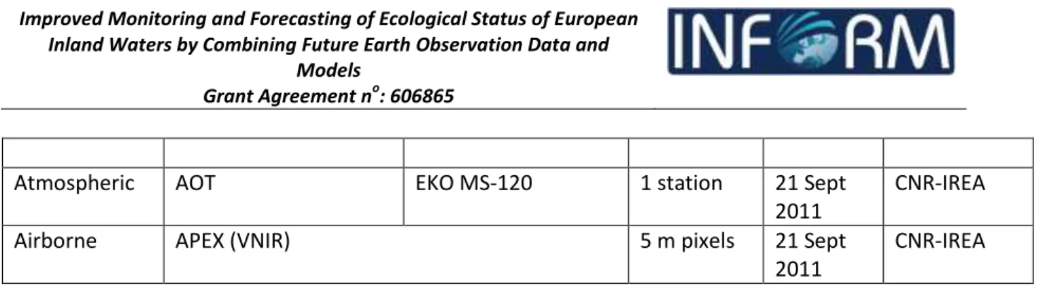
Atmospheric AOT EKO MS-120 1 station 26 July
2007
CNR-IREA
Airborne MIVIS (VNIR) 5 m pixels 26 July
2007
CNR-IREA In-situ AOPs
macrohytes
R(0+) Field ASD-FR 15 sites, 6
species 07 May 2007, 29 June 2007 and 26 July 2007 CNR-IREA
Table 8. Overview of data collected at Mantua lakes in 2011 available to the INFORM project for use in WP5 and WP6.
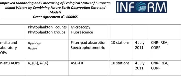
Data Data specification Method / Instrument Coverage / Resolution Date Host organisation In-situ water constituents Chla TSM CDOM Chla, PC, PE Phytoplankton counts Spectrophotometric Gravimetric Spectrophotometric In-situ fluorescence Microscopy 35 stations 6-29 Sept 2011 CNR-IREA In-situ / laboratory IOPs aph,aNAP aCDOM Filter-pad absorption Spectrophotometric 26 stations 6-29 Sept 2011 CNR-IREA
In-situ AOPs Rrs(0+), R(0-) ASD-FR 13 stations 6-29 Sept
2011
D4.1
Improved Monitoring and Forecasting of Ecological Status of European Inland Waters by Combining Future Earth Observation Data and
Models
Grant Agreement no: 606865
INFORM_D4.1_v1.0 D4.1 Page 22 of 48
Atmospheric AOT EKO MS-120 1 station 21 Sept
2011
CNR-IREA
Airborne APEX (VNIR) 5 m pixels 21 Sept
2011
CNR-IREA
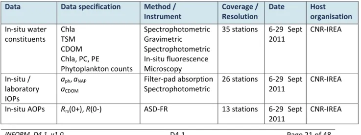
Table 9. Overview of other data collected at Mantua Lakes available to the INFORM project for use in WP5 and WP6.
Data Data specification Method / Instrument Coverage / Resolution Date Host organisation In-situ water constituents Chla TSM CDOM Spectrophotometric Gravimetric Spectrophotometric 9 stations 19 July 2010 and 9 August 2010 CNR-IREA In-situ / laboratory IOPs aph,aNAP aCDOM bbp Filter-pad absorption Spectrophotometric HOBI Labs Hydroscat-6 6 stations 6-29 Sept 2011 CNR-IREA
In-situ AOPs Rrs(0+), R(0-) ASD-FR 9 stations 6-29 Sept
2011
CNR-IREA
Spaceborne CHRIS-PROBA (VNIR) 29 June
2008 and 16 August 2008, 28 August 2011, 6 August 2012 CNR-IREA & ESA
D4.1
Improved Monitoring and Forecasting of Ecological Status of European Inland Waters by Combining Future Earth Observation Data and
Models
Grant Agreement no: 606865
INFORM_D4.1_v1.0 D4.1 Page 23 of 48
5.
Venice lagoon
5.1.
Site description
The Venice Lagoon at ~550 km2 is the largest shallow coastal lagoon in the Mediterranean. It maintains a connection to the Adriatic Sea through the inlets of Lido, Malamocco, and Chioggia. The Lagoon has an average water depth of about 1.1 m and a maximum tidal range of about 1.5 m, with a main period of about 12 h. The majority of the lagoon is comprised of shallow water, mud flats and saltwater marshes. The lagoon has been subject to intense anthropogenic pressure over the past few decades from hydrological modification resulting from flood defence works and eutrophication. Key ecological impacts include the extensive loss of benthic seagrass cover.
5.2.
Monitoring data
Data from long-term monitoring projects of seagrasses distribution are reported in technical reports available to the project for WP5 and WP6. The long-term monitoring programmes were led by local authorities with the aim of mapping the three species of seagrasses, which colonized the Venice Lagoon. The results are represented by seasonal distribution of seagrass, based on “traditional” in-situ surveys. These maps will be available for the validation of Earth observation products.
Data contact
Federica Braga, Institute of Marine Sciences, [email protected]
5.3.
Campaign data
CNR has undertaken sampling campaigns in Venice Lagoon from 2002 during which airborne and satellite hyperspectral data, optical data and in-situ water quality data were collected. These data are also available to the project for WP5 and WP6. The sampling campaigns operated by CNR have involved two different approaches:
(1) the collection of radiometric measurements for a spectral characterization of seagrasses, with different tidal levels. They were undertaken in 2002, 2003 and 2011.
(2) IOP and AOP in-situ measurements and water samples in deep optical water, undertaken in 2001 and 2005, during airborne and satellite overpasses.
An overview of the in-situ, airborne and spaceborne data is provided in Table 10 and Table 11. Other IOP and AOP in-situ measurements and water samples in optically deep waters were undertaken by CNR in 2011 and 2012.
Data contact
Federica Braga, Institute of Marine Sciences, [email protected].
D4.1
Improved Monitoring and Forecasting of Ecological Status of European Inland Waters by Combining Future Earth Observation Data and
Models
Grant Agreement no: 606865
INFORM_D4.1_v1.0 D4.1 Page 24 of 48
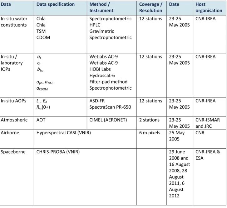
Table 10. Overview of data collected at Venice Lagoon in 2005 available to the INFORM project for use in WP5 and WP6.
Data Data specification Method / Instrument Coverage / Resolution Date Host organisation In-situ water constituents Chla Chla TSM CDOM Spectrophotometric HPLC Gravimetric Spectrophotometric 12 stations 23-25 May 2005 CNR-IREA In-situ / laboratory IOPs at ct bbp aph, aNAP aCDOM Wetlabs AC-9 Wetlabs AC-9 HOBI Labs Hydroscat-6 Filter-pad method Spectrophotometric 12 stations 23-25 May 2005 CNR-IREA In-situ AOPs Lu, Ed Rrs(0+) ASD-FR SpectraScan PR-650 12 stations 23-25 May 2005 CNR-IREA
Atmospheric AOT CIMEL (AERONET) 2 stations 23-25
May 2005
CNR-ISMAR and JRC
Airborne Hyperspectral CASI (VNIR) 6 m pixels 25 May
2005
CNR
Spaceborne CHRIS-PROBA (VNIR) 29 June
2008 and 16 August 2008, 28 August 2011, 6 August 2012 CNR-IREA & ESA
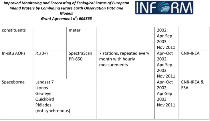
Table 11. Overview of data collected at Venice Lagoon for seagrass spectral characterization available to the INFORM project for use in WP5 and WP6.
Data Data
specification
Method / Instrument
Coverage / Resolution Date Host
organisation
D4.1
Improved Monitoring and Forecasting of Ecological Status of European Inland Waters by Combining Future Earth Observation Data and
Models Grant Agreement no: 606865 INFORM_D4.1_v1.0 D4.1 Page 25 of 48 constituents meter 2002; Apr-Sep 2003 Nov 2011 In-situ AOPs Rrs(0+) SpectraScan
PR-650
7 stations, repeated every month with hourly measurements Apr–Oct 2002; Apr-Sep 2003 Nov 2011 CNR-IREA Spaceborne Landsat 7 Ikonos Geo-eye Quickbird Pléiades (not synchronous) Apr–Oct 2002; Apr-Sep 2003 Nov 2011 CNR-IREA & ESA
Table 12. Overview of data collected at Venice Lagoon in 2011-2012 available to the INFORM project for use in WP5 and WP6.
Data Data specification Method / Instrument Coverage / Resolution Date Host organisation In-situ water constituents Chla TSM CDOM Spectrophotometric Gravimetric Spectrophotometric 18 stations 27-28 Oct 2011 23-24 July 2012 CNR-IREA and Klaipeda University In-situ / laboratory IOPs bbp aph, aNAP aCDOM Particle size distribution and volume concentration HOBI Labs Hydroscat-6 Filter-pad method Spectrophotometric LISST-100X 18 stations 27-28 Oct 2011 23-24 July 2012 CNR-IREA and Klaipada University In-situ AOPs Rrs(0+) Rrs(0+) SpectraScan PR-650 WISP-3 18 stations 27-28 Oct 2011 23-24 July 2012 CNR-IREA and Klaipeda University
Atmospheric AOT CIMEL (AERONET) 1 station 27-28 Oct
2011 23-24 July 2012 JRC, CNR-IREA and Klaipeda University
D4.1
Improved Monitoring and Forecasting of Ecological Status of European Inland Waters by Combining Future Earth Observation Data and
Models
Grant Agreement no: 606865
INFORM_D4.1_v1.0 D4.1 Page 26 of 48
6.
Lake Constance
6.1.
Site description
Lake Constance is the second largest lake in Western Europe with a surface area of approximately 535 km2. It is located at 395 m a.s.l. and has a mean and maximum depth of 101 m and 253 m, respectively. The Alpenrhein River is the main inlet, accounting for 62% of the total inflow. Lake Constance is naturally an oligotrophic system, but increased nutrient inputs led to eutrophication of Lake Constance in the late 1970s. The lake has since undergone 20 years of nutrient reduction and has returned to oligotrophic status. Phytoplankton chlorophyll-a concentrations peak during the diatom-dominated spring bloom (approximately 10 mg m-3) but are otherwise relatively low (approximately 1 mg m-3 in winter and 3-5 mg m-3in summer through autumn).
6.2.
Available data
Datasets have been already generated in the frame of the FP7 FRESHMON project (www.freshmon.eu) for Lake Constance. These datasets were acquired during several field campaigns in 2012. The in-situ measurements (WISP-3, water constituents, etc.) were conducted commonly by Eawag and ISF. EOMAP processed the satellite data. In addition, a publication by Pitarch et al. 2014 presents the results of retrieved in-situ suspendend matter and Rrs for 18 stations over a stepwise depth profile from 0 to 20m. The published data can be used as validation source for the stratification algorithm (upon approval of the data owners). Further vertical profile data measured provided by the Lake Research Institute of the Environmental Agency Baden-Württemberg (ISF) have been requested but not yet confirmed.
Data contact
Karin Schenk, EOMAP, [email protected] (data policy for in-situ data according to user practice)
Table 13. Overview existing and to be used data for Lake Constance available to the INFORM project for use in WP5 and WP6.
Data Data specification Date Host
organisation
Availability
Spaceborne RapidEYE 3-4 May 2012 EOMAP Yes
MODIS Aqua and Terra 25 May 2012 EOMAP Yes Landsat-8 OLI
Landsat-7 ETM+
Selected dates*
EOMAP Yes
MODIS Aqua and Terra Selected dates* EOMAP Yes In-situ (routine monitoring program) Turbidity vertical profiles
To be defined ISF Unclear, data request ongoing In-situ Vertical profiles of TSM 25 May 2012 Eawag Only upon approval
D4.1
Improved Monitoring and Forecasting of Ecological Status of European Inland Waters by Combining Future Earth Observation Data and
Models
Grant Agreement no: 606865
INFORM_D4.1_v1.0 D4.1 Page 27 of 48
(campaign-based) and Rrs(0+) of the data owner
D4.1
Improved Monitoring and Forecasting of Ecological Status of European Inland Waters by Combining Future Earth Observation Data and
Models
Grant Agreement no: 606865
INFORM_D4.1_v1.0 D4.1 Page 28 of 48
7.
Gironde River
7.1.
Site description
The Gironde Estuary, southwest France, is one of the largest estuaries on the European Atlantic coast. It is characterised by a well-developed turbidity maximum and very high TSM that can range from 150 to approximately 3000 mg/L in near surface waters.
7.2.
Monitoring
Since 2004, the MAGEST (MArel Gironde ESTuary) monitoring network, provides real-time, continuous measurements of the water quality of the Gironde estuary, based on four automated stations. There is one station at Pauillac which measures turbidity in NTU. There is a restricted data policy. In order to use the data it is necessary to obtain an agreement with the researchers of MAGEST. For more information see: H. Etcheber, S. Schmidt, A. Sottolichio, E. Maneux, G. Chabaux, J.-M. Escalier, H. Wennekes, H. Derriennic, M. Schmeltz, L. Quéméner, M. Repecaud, P. Woerther, and P. Castaing, 2011, Monitoring water quality in estuarine environments: lessons from the MAGEST monitoring program in the Gironde fluvial-estuarine system, Hydrol. Earth Syst. Sci., 15, 831-840.
7.3.
Campaigns
VITO has undertaken two sampling campaigns in the Gironde estuary in June 2012 and August 2013. In-situ measurements were collected on fixed pontoons and on a vessel. In addition hyperspectral airborne data were collected in 2012. Additional monitoring data is available from MAGEST (MArel Gironde ESTuary), but with a restricted data policy. An overview of the in-situ, airborne and spaceborne data is given below for the year 2012 and 2013.
Data contact
Els Knaeps, VITO, [email protected]
Table 14. Overview of data collected at Gironde River in 2012 for use in WP5, Task 5.3 (*denotes data only available for use by other INFORM partners after approval by the host organization).
Data Data specification Method / Instrument Coverage / Resolution Date Host organisation In-situ water constituents Chla TSM Turbidity HPLC Gravimetric HACH 2100P ISO turbidimeter 45 stations 11-16 June 2012 VITO, LOV*
D4.1
Improved Monitoring and Forecasting of Ecological Status of European Inland Waters by Combining Future Earth Observation Data and
Models Grant Agreement no: 606865 INFORM_D4.1_v1.0 D4.1 Page 29 of 48 laboratory IOPs aCDOM bbp Spectrophotometric BB3 2012 In-situ AOPs Rw(0+) Rw(0+) TriOS RAMSES ASD FR 45 stations 11-16 June 2012 VITO, RBINS*
Airborne APEX (VNIR-SWIR) Part of the
width of the estuary from Blaye to mouth
14 June 2012 VITO
Table 15. Overview of data collected at Gironde River in 2013 for use in WP5, Task 5.3 (*denotes data only available for use by other INFORM partners after approval by the host organization).
Data Data specification Method / Instrument Coverage / Resolution Date Host organisation In-situ water constituents TSM Turbidity Gravimetric HACH 2100P ISO turbidimeter 27 stations 12-16 August 2013 VITO, LOV* In-situ / laboratory IOPs at bbp bbp Wetlabs AC-9 Wetlabs BB3
HOBI Labs Hydroscat-4
27 stations 12-16 August 2013 LOV, RBINS* In-situ AOPs Rw(0+) Rw(0+) TriOS RAMSES ASD FR 27 stations 12-16 August 2013 VITO, RBINS*
D4.1
Improved Monitoring and Forecasting of Ecological Status of European Inland Waters by Combining Future Earth Observation Data and
Models
Grant Agreement no: 606865
INFORM_D4.1_v1.0 D4.1 Page 30 of 48
8.
Scheldt River
VITO has undertaken four sampling campaigns in the Scheldt river in June 2010, October 2010 and June 2012. In-situ measurements were collected on a fixed pontoon. In addition, hyperspectral airborne data were collected in 2012.
8.1.
Site description
The Scheldt River rises in Northern France and flows through Belgium and the Netherlands to the North Sea. The river is rain-fed and the average discharge varies considerable between summer-autumn (60 m3/s) and winter-spring (180 m3/s). The Scheldt River is highly turbid with TSM concentrations in excess of 50 mg/L in near surface waters. However, TSM concentrations are highly variable and respond to tidal and season cycles. The tide regime is semi-diurnal and its influence extends 82 km upstream as far as Ghent. The mud in the Scheldt Estuary is derived from both marine and terrestrial sources. The terrestrial sources include waste water, soil surface erosion, erosion of the exposed clay layers at the bottom of the estuary, and precipitation. Chlorophyll-a concentrations are typically 10-20 mg m-3 but can exceed 100 mg m-3 during summer phytoplankton blooms.
8.2.
Monitoring
There are limited additional monitoring data available from the Flemish Environment Agency (VMM). The Flemish Environment Agency (VMM) has a water monitoring network in place. One of the stations is situated in the INFORM study area of the Scheldt river. One of the parameters that are being measured is the TSM concentration. However data has not been collected continuously. The VMM provides a webservice to view the data that have been collected at the various stations (http://geoloket.vmm.be/Geoviews/).
8.3.
Campaigns
VITO has undertaken four sampling campaigns in the Scheldt river in June 2010, October 2010 and June 2012. In-situ measurements were collected on a fixed pontoon. In addition, hyperspectral airborne data were collected in 2012. An overview of the in-situ, airborne and spaceborne data is given below for the year 2010 and 2012.
Data contact
D4.1
Improved Monitoring and Forecasting of Ecological Status of European Inland Waters by Combining Future Earth Observation Data and
Models
Grant Agreement no: 606865
INFORM_D4.1_v1.0 D4.1 Page 31 of 48
Table 16. Overview of data collected at Scheldt river in 2010 for use in WP5, Task 5.3 3 (*denotes data only available for use by other INFORM partners after approval by the host organization).
Data Data specification Method / Instrument Coverage / Resolution Date Host organisation In-situ water constituents Chla TSM Turbidity HPLC Gravimetric HACH 2100P ISO turbidimeter 45 stations 11-16 June 2010 VITO, LOV* In-situ / laboratory IOPs aph, aNAP aCDOM bbp Filter-pad method Spectromphotometric BB3 45 stations 11-16 June 2010 LOV, RBINS* In-situ AOPs Rw(0+) Rw(0+) TriOS RAMSES ASD FR 45 stations 11-16 June 2010 VITO, RBINS*
Table 17.Overview of data collected at Scheldt river in 2012 for use in WP5, Task 5.3 3 (*denotes data only available for use by other INFORM partners after approval by the host organization).
Data Data specification Method / Instrument Coverage / Resolution Date Host organisation In-situ water constituents Chla TSM Turbidity HPLC Gravimetric HACH 2100P ISO turbidimeter 45 stations 11-16 June 2012 VITO, LOV* In-situ / laboratory IOPs aph, aNAP aCDOM bbp Filter-pad method Spectromphotometric BB3 45 stations 11-16 June 2012 LOV, RBINS* In-situ AOPs Rw(0+) Rw(0+) TriOS RAMSES ASD FR 45 stations 11-16 June 2012 VITO, RBINS*
Airborne APEX (VNIR-SWIR) Scheldt
between Antwerp city and Lillo
D4.1
Improved Monitoring and Forecasting of Ecological Status of European Inland Waters by Combining Future Earth Observation Data and
Models
Grant Agreement no: 606865
INFORM_D4.1_v1.0 D4.1 Page 32 of 48
9.
Esthwaite Water
9.1.
Site description
Esthwaite Water is a small (1.13 km2), productive monomitic lake in the English Lake District. It has a mean depth of 6.4 m and a maximum depth of approximately 25 m. The lake is eutrophic and receives nutrients from a local sewage treatment works and fish farm. The spring bloom is typically dominated by diatoms, although cyanobacterial blooms can also occur during unseasonally warm weather. During summer, dense cyanobacterial blooms composed of genera such as Anabaena, Aphanizomenon and Microcystis often occur.
9.2.
Monitoring data
Esthwaite Water is monitored fortnightly by the NERC Centre for Ecology & Hydrology (CEH) (Lancaster). In addition, as part of the UKLEON network, an automatic monitoring buoy records basic limnological and meterological data (e.g., PAR, wind speed and direction, air temperature, water temperature, pH, CO2,
dissolved oxygen, chlorophyll fluorescence, phycocyanin fluorescence) at high temporal resolution. These data may be available on request from CEH subject to a data agreement.
Data contact
Professor Stephen Maberly, Lake Ecosystems Group, Centre for Ecology & Hydrology, Lancaster Environment Centre; [email protected]
9.3.
Campaign data
USTIR led a sampling campaign on Esthwaite Water during April 2007. These campaigns included measurement of AOPs and water constituents concurrent to airborne flights. An overview of these data is provided in Table 18 below.
Data contact
Dr Peter Hunter, University of Stirling, [email protected]
Table 18. Overview of data collected at Esthwaite Water in 2007 available to the INFORM project for use in WP5 and WP6. Data Data specification Method / Instrument Coverage / Resolution Date Host organisation In-situ water constituents Chla PC TSM (tbc) Microcystins Spectrophotometric Spectrophotometric Gravimetric HPLC / ELISA
D4.1
Improved Monitoring and Forecasting of Ecological Status of European Inland Waters by Combining Future Earth Observation Data and
Models Grant Agreement no: 606865 INFORM_D4.1_v1.0 D4.1 Page 33 of 48 Phytoplankton counts Microscopy
In-situ AOPs R(0+) ASD FieldSpec HH 5 stations 26 April 2007 USTIR
Airborne AISA Eagle-Hawk (VNIR-SWIR) Full lake at 2 m pixels
26 April 2007 USTIR, NERC ARSF
D4.1
Improved Monitoring and Forecasting of Ecological Status of European Inland Waters by Combining Future Earth Observation Data and
Models
Grant Agreement no: 606865
INFORM_D4.1_v1.0 D4.1 Page 34 of 48
10.
Loch Leven
10.1.
Site description
Loch Leven is the largest lake (13.3 km2) in lowland Scotland (56°12′N, 3°22′W) with mean and maximum depths of 3.9 m and 25.2 m respectively. The lake is typically well mixed and rarely stratifies. Loch Leven has been adversely affected by nutrient inputs from domestic, agricultural and industrial sources and, while there is some evidence for recovery, cyanobacterial blooms continue to occur during summer months. These blooms are typically dominated by genera such as Anabaena, Microcystis, Snowella and Woronichinia.
10.2.
Monitoring data
Loch Leven is monitored fortnightly by the NERC Centre for Ecology & Hydrology (Lancaster). In addition, as part of the UKLEON network, an automatic monitoring buoy records basic limnological data at high temporal resolution. These data may be available on request from CEH subject to a data agreement.
Data contact
Dr Laurence Carvalho, Centre for Ecology & Hydrology, Penicuik, Edinburgh; [email protected]
10.3.
Campaign data
USTIR led a sampling campaigns on Loch Leven during April and August 2007. These campaigns included measurement of AOPs and water constituents concurrent to airborne flights. An overview of the these data is provided in Table 19 below.
Data contact
Dr Peter Hunter, University of Stirling, [email protected]
Table 19.Overview of data collected at Loch Leven in 2007 available to the INFORM project for use in WP5 and WP6. Data Data specification Method / Instrument Coverage / Resolution Date Host organisation In-situ water constituents Chla PC TSM (tbc) Microcystins Phytoplankton counts Spectrophotometric Spectrophotometric Gravimetric HPLC / ELISA Microscopy 10 stations 13 April, 22 August 2007 USTIR, CEH
D4.1
Improved Monitoring and Forecasting of Ecological Status of European Inland Waters by Combining Future Earth Observation Data and
Models
Grant Agreement no: 606865
INFORM_D4.1_v1.0 D4.1 Page 35 of 48 2007, 22
August 2007 Airborne AISA Eagle-Hawk (VNIR-SWIR)
Itres CASI-2 (multispectral VNIR)
Full lake at 2 m pixels 13 April 2007, 22 August 2007 USTIR, NERC ARSF
D4.1
Improved Monitoring and Forecasting of Ecological Status of European Inland Waters by Combining Future Earth Observation Data and
Models
Grant Agreement no: 606865
INFORM_D4.1_v1.0 D4.1 Page 36 of 48
11.
IJsselmeer
11.1.
Site description
The IJsselmeer was created after closure of a dam (the Afsluitdijk) in 1932 that resulted in a transformation of the Southern Sea (an estuary) into a freshwater lake. The main source of freshwater is the river IJssel, a tributary of the river Rhine. The IJsselmeer is a Heavily Modified Water Body according to WFD terminology. The IJsselmeer and Markermeer lakes have experienced declines in certain species of waterfowl, including diving ducks and fish-eating birds.
11.2.
Monitoring data
Deltares implemented a five-year research programme to investigate the causal mechanisms of the downward trends in waterfowl, to study effective measures to counteract the downward trends and their cost, and finally to define feasible conservation goals. This programme (Autonomous Downward Trend) not only collected data on numbers of waterfowl species but also of several water quality parameters such as TSM, Chl-a, transparency and nutrients. It included two automatic monitoring buoys in the lake for several of these parameters. Rijkswaterstaat monitors their water bodies continuously, including the IJsselmeer. These data are stored in a public database (live.waterbase.nl).
11.3.
Campaign description
The EU FP7 project FRESHMON produced water quality data (TSM and Chl-a) for Lake Markermeer on behalf of Deltares.
D4.1
Improved Monitoring and Forecasting of Ecological Status of European Inland Waters by Combining Future Earth Observation Data and
Models
Grant Agreement no: 606865
INFORM_D4.1_v1.0 D4.1 Page 37 of 48
12.
Lake Geneva
12.1.
Site description
Lake Geneva (89 km3, 580 km2), the largest freshwater body in Western Europe, is still recovering from his eutrophication over the last century. The excessive load of nutrients led to a total phosphorus concentration of up to 90 g/L in the 1980s but active restoration plans including construction of waste water treatment plants, and bans on phosphorus in textile washing products, have gradually improved the trophic status of the lake. Nowadays, the lake is back to a mesotrophic state but still far from its targeted phosphorus goal (10-15 g/L).
12.2.
Monitoring data
Since 1957, the Commission Internationale pour la Protection des Eaux du Léman (CIPEL) is coordinating the monitoring of Lake Geneva with a monthly to bi-monthly sampling period over at least two in-situ locations. Lake Geneva is continuously monitored by the CIPEL for TSM, chlorophyll-a, Secchi depth and several other water quality parameters. The data are available on request. In addition EPFL has performed in-situ radiometric and water constituents analysis on a regular basis since 2013.
12.3.
Campaign data
Data from previous remote sensing campaigns conducted by EPFL and Eawag is summarised in Table 20.
Table 20.Overview of data collected at Lake Geneva available to the INFORM project for use in WP5 and WP6. Data Data specification Method / Instrument Coverage / Resolution Date Host organisation In-situ water constituents Chla Fluorescence TSM Turbidity DOC Spectrophotometric WetLabs ECO-FLS Gravimetric Wetlabs C-star transmissiometer Chemiluminescence 150 stations May, July 2013 February, March, April, May, June, September 2014 EPFL
In-situ AOPs Rw(0+) TriOS Ramses
Water Insight WISP-3
150 stations May, July 2013 February, March, April, May, June, September EPFL
D4.1
Improved Monitoring and Forecasting of Ecological Status of European Inland Waters by Combining Future Earth Observation Data and
Models Grant Agreement no: 606865 INFORM_D4.1_v1.0 D4.1 Page 38 of 48 2014 In-situ IOPs a c bb WetLabs ac-9 WetLabs bb-3
6 stations June 2014 USTIR
Airborne APEX, RapidEye, Ultra Light Airplane (EPFL) 14 May 2013 ULM: May,July 2013 February, March, April, May, September 2014
Spaceborne HICO 19 July 2014
and 2 September 2014
D4.1
Improved Monitoring and Forecasting of Ecological Status of European Inland Waters by Combining Future Earth Observation Data and
Models
Grant Agreement no: 606865
INFORM_D4.1_v1.0 D4.1 Page 39 of 48
13.
LIMNADES
LIMNADES (Lake Bio-optical Measurements and Matchup Data for Remote Sensing) is a community owned database of lake IOP, AOP and in-water biogeochemical constituent data for remote sensing algorithm development and validation established through the UK NERC GloboLakes project. LIMNADES data are either publicly available or available upon request from the contributor or Principal Investigator (PI). Currently, LIMANDES contains data for over 1100 lakes globally (Figure 2). Of these, 70 lakes have in-situ water-leaving reflectance data with measurements from over 2400 stations. IOP data are available for approximately one-quarter of these stations. Most LIMNADES datasets are available for use in the INFORM project subject to agreement with the appropriate PI. More information is provided here: http://www.globolakes.ac.uk/limnades/ and a full list of lakes with available AOP/IOP data is provided in Annex 1.
Data contact
Dr Peter Hunter, University of Stirling, [email protected]
Dr Vagelis Spyrakos, , University of Stirling, [email protected]
Figure 2. Geographic distribution of datasets contributed to LIMNADES. (Correct as 01 December 2014).
D4.1
Improved Monitoring and Forecasting of Ecological Status of European Inland Waters by Combining Future Earth Observation Data and
Models
Grant Agreement no: 606865
INFORM_D4.1_v1.0 D4.1 Page 40 of 48
14.
Gap analysis
Data requirements for WP5 and WP6, including in-situ IOPs, AOPs and in-water constituents, were compiled through a spreadsheet-based questionnaire completed by all partners. This is available to project partners on the INFORM MOSS portal1. This gap analysis is based on these requirements and the
information provided in this report in relation to the existing datasets held by INFORM partners. Table 21 provides an overview of the existing data available for use in the INFORM project for each study site. The existing datasets held by INFORM partners encompass a wide range of water types from oligotrophic lakes, eutrophic lagoons and sediment-laden rivers and estuaries. In general, these sites encompass most of the water types highlighted by INFORM partners in regards to their requirements for WP5. In total, INFORM partners hold existing data for approximately 396 stations on the INFORM study sites. Several sites such as Lake Balaton, Curonian Lagoon and the Scheldt and Gironde estuaries have extensive existing data available. Moreover, several of these sites have complete datasets including in-situ optical data (IOPs and AOPs), in-water biogeochemical constituents and airborne/spaceborne EO data. These are high-value datasets and these will be fundamental to the algorithm development and validation tasks planned for WP5. The sections below provide a summary of the available data and an analysis of the potential gaps with respect to the data needs for the INFORM participants.
IOP and AOP datasets
In-situ IOP data are available for most lake and lagoon sites, except Lake Constance, Ijsselmeer, Esthwaite Water and Loch Leven – although IOP data for the latter site exists and will be made available via the LIMNADES database in the near future. The availability of IOP data is most limited for the oligotrophic and mesotrophic lakes, with most measurements from more eutrophic systems. However, there are additional IOP datasets potentially available through LIMNADES from more oligotrophic, clear water lakes. The Scheldt and Gironde rivers have limited IOP data and access to these can only be granted upon approval by the hosting organization, but these data are not widely. Most of the IOP data are from surface stations, with fewer measurements from depth-profiles – partly this reflects the fact that many of the data were collected in optically and/or physical shallow systems. The approaches used for the measurement of IOPs are internally consistent (i.e., within the dataset) but instruments, methods and protocols vary across sites and datasets. In-situ water-leaving reflectance data are available for all sites (and the vast majority of sampling stations) and can be used directly to develop and test algorithm and also to simulate satellite sensors. The radiometric datasets are internally consistent, but the instruments, methods and protocols vary across sites and datasets.
Biogeochemical datasets
In-situ biogeochemical are available for all lakes, this includes data collected as part of previous remote sensing campaigns and those available from long-term monitoring programmes. However, the completeness of these datasets varies between sites. Basic parameters such as TSM and Chla are available for all sites (except Lake Constance), but other parameters such as CDOM are only available for selected sites. HPLC pigments, turbidity (ISO method 7027), phytoplankton count and primary productivity data are only available for a few sites.
1https://esites.vito.be/sites/inform/Documents%20Exchange/WP4/T4.1%20Existing%20data%20and%20data%20gaps
D4.1
Improved Monitoring and Forecasting of Ecological Status of European Inland Waters by Combining Future Earth Observation Data and
Models
Grant Agreement no: 606865
INFORM_D4.1_v1.0 D4.1 Page 41 of 48
Airborne hyperspectral datasets
Eight of the eleven study sites have existing airborne multispectral or hyperspectral data available. These datasets include imagery from APEX, CASI, AISA Eagle/Hawk and the MIVIS instruments. These data are available to all INFORM project partners. In all cases, the existing airborne or hyperspectral datasets are accompanied by in-situ reflectance measurements and biogeochemical data. In addition, some are also supported by complete IOP datasets. In-situ data concurrent to the APEX data from the Scheldt and Gironde rivers are only available upon approval by the host organisation. There are concurrent AOT measurements available to support atmospheric correction studies for some but not all airborne datasets.
Satellite datasets
MERIS, MODIS and Landsat data are available for all sites and can be obtained from existing open-access archives held by ESA, NASA and the USGS. In addition, CHRIS-PROBA data are available for the Mantua Lakes and the Curonian Lagoon. R