http://dx.doi.org/10.4236/jss.2016.43008
How to cite this paper: Leng, L. and Zhang, Y. (2016) Spatial Models of River Channel Planforms in Geographic Information System. Open Journal of Social Sciences, 4, 48-53. http://dx.doi.org/10.4236/jss.2016.43008
Spatial Models of River Channel Planforms
in Geographic Information System
Liang Leng
1*, Yan Zhang
21Applied Technology College, Jilin University, Changchun, China 2Zhejiang Institute of Geological Survey, Hangzhou, China
Received 8 January 2016; accepted 26 February 2016; published 1 March 2016
Abstract
Rivers which are important objects in real world need be appropriately described in Geographic Information System to be conveniently inquired and detailed analyzed for human being. Many spatial models were proposed in the past, but spatial models with regard to river channel plan- forms (RCPs) are lesser-known. This work proposes spatial models of river channel planforms (SMRCPs) based on the properties of river channel planforms in the real world and the spatial re-lation theory. We proposed the segment conditions based on RCPs properties in Geographic In-formation System to describe rivers in the real world by SMRCPs in detail.
Keywords
Spatial Models, River Channel Planforms, Segment Condition, Sinuous, Braided
1. Introduction
Rivers are widely regarded as the world’s most important objects which influence human settlement, develop-ment of agriculture and industry, transport, and disasters, the human activity moreover makes river changed in morphology, water quality, and biodiversity which could significantly react back to human activity [1]-[5]. Riv-er morphology has been a subject of great challenge of scientists and engineRiv-ers who recognize that any effort with regard to river engineering must be based on a proper understanding of the morphological features involved and the responses to the imposed changes.
A river channel planform (RCP) is mostly like a narrow band, which is nearly linear for the width of the channel is much than its length, contained some bars. In Geographic Information System a RCP is almost scribed as a narrow region with some holes or merely a line when the width of the channel is too small to be de-scribed as a narrow region at a specific scale. Spatial relations are spatial constrains among spatial objects such as points, lines and regions, which can be utilized to speed up spatial query, analysis and graphic display. Users must employ the spatial relations between objects at different time to make the change detection of river channel planforms (RCPs) faster and more accurate. The spatial relations between RCPs could be mostly represented by region and region, line and region, line and line when the planform should be described as a line, moreover
spa-*
2. River Channel Planforms in the Real World
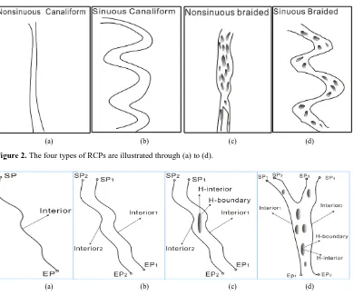
RCPs in the real world are diversiform and complicated because of the impact of nature factors such as earth-quake, flood and geological formation, and anthropogenic influence such as building dams, destroying plants on banks and repairing channels. Every river channel planform is different in detail thus there is no one spatial model fits all. Leopold and Wolman firstly proposed the conception of RCPs [6]. According to direct observa-tion Drury provided the first complete classificaobserva-tion of river channel planforms which is divided into eight types of river channel planform models such as meandering channel, braided channel, straight channel, deltaic distri-butary channel, anabranching channel, reticulate channel and Irregular channel [7]. The classification by Brice based on four major planform properties that are most readily observed on aerial photographs: sinuous canali- form, sinuous point bar, sinuous braided, and nonsinuous braided [8]. Miall divided RCP into braided, mean-dering, reticulate, and straight ones based on its properties [9]. The classification by Rust based on degrees of sinuous and braiding is the same as Miall’s [10]. Qian et al. proposed the classification which is consist of wan-dering channel, meanwan-dering channel, straight channel, and anabranching channel, the first difference between the classification of Qian et al. and Rust is whether anabranching channel and reticulate channel is the same RCP type [11]. According to existing classifications the key characters of RCP classification are degrees of si-nuous, braiding, and anabranching which are illustrated in Figures 1(a)-(c) respectively. In Figure 1(a) the RCP is differentiated by degrees of sinuous. In Figure 1(b) the RCP is differentiated by degrees of braiding. In Fig-ure 1(a) the RCP is differentiated by degrees of anabranching.
Because the characters of braiding and anabranching are easily confused for people and difficult to differen-tiated in Geographic information system, we make the character of anabranching degress belong to the degrees of braiding and use the degrees of sinuous and braiding to classify RCPs. In this paper RCPs are classified into nonsinuous canaliform, sinuous canaliform, nonsinuous braided, and sinuous braided based on the characters of braiding and sinuous which are illustrated in Figure 2(a)-(d) respectively. Nonsinuous canaliform is illustrated in Figure 2(a). Sinuous canaliform is illustrated in Figure 2(b). Nonsinuous braided is illustrated in Figure 2(c). sinuous braided is illustrated in Figure 2(d).
3. Spatial Models of RCPs in Geographic Information System
Spatial models of RCPs (SMRCPs) in Geographic Information System root in RCPs of the real world, and they have some special properties. First of all, SMRCPs in GIS could be described by single irregular curve, double irregular curves, and double irregular curves with holes in the wake of different scales. In addition, double irre-gular curves with single hole and double irreirre-gular curves with multiple holes are different in spatial relations, we consider them as two cases. Finally the degree of sinuous is not the key property to distinguish objects in spatial relation, therefore we consider irregular curves as the same type in despite of different degree of sinuous. In this paper, SMRCPs are divided into single irregular curve, double irregular curves, double irregular curves with single hole, and double irregular curves with multiple holes which are illustrated in Figures 3(a)-(d) respective-ly. Figure 3(a) illustrates single irregular curve of SMRCP. Figure 3(b) illustrates double irregular curves of SMRCP. Figure 3(c) illustrates double irregular curves with single hole of SMRCP. Figure 3(d) illustrates double irregular curves with multiple holes of SMRCP. The irregular curves are consist of interior and boundary (two extreme points), and the holes are consist of interior (H-interior) and boundary (H-boundary).
(a) (b) (c)
Figure 1.The three characters of RCP classification are illustrated through (a) to (c).
[image:3.595.121.511.259.585.2](a) (b) (c) (d)
Figure 2. The four types of RCPs are illustrated through (a) to (d).
(a) (b) (c) (d)
Figure 3.The four types of SMRCPs are illustrated through (a) to (d).
(DSLSH), and double straight lines with multiple holes (DSLMH) which are shown in Figures 4(a)-(d) respec-tively. Figure 4(a) shows SSL which is a straight line with interior and boundary (two extreme points), Figure 4(b) shows DSL which are consist of two single straight lines, Figure 4(c) shows DSLSH which are consist of two single straight lines and a hole within, Figure 4(d) shows DSLMH which are consist of two single straight lines and several holes within.
4. River Descriptions by SMRCPs
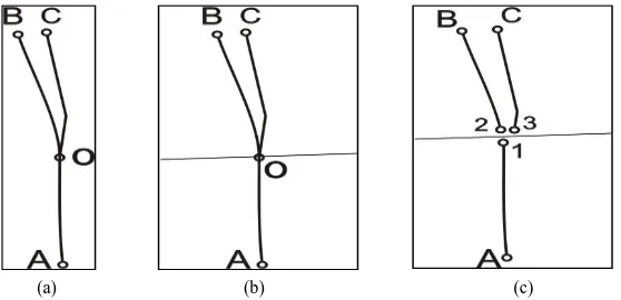
model will change, therefore, it is not suitable to segment the river at this position. In Figure 5(b) after Straight line A and α respectively extend a length of ε1, ε2, δ1, and δ2, the spatial model did not change, therefore, it
is suitable to segment the river at this position.
Condition 2. If a river in real world becomes wider, meanwhile, the spatial models developed from SSL to DSL, we segment the river into two segments which are described by SSL and DSL as shown in Figure 6. Fig-ure 6(a) shows a river becomes wider from SSL to DSL. FigFig-ure 6(b) shows the segment line which is segment the river to two segments. Figure 6(c) shows two river segments corresponding to two spatial models as SSL and DSL.
[image:4.595.116.511.276.388.2](a) (b) (c) (d)
Figure 4. The four types of SMRCPs are illustrated through (a) to (d).
[image:4.595.171.451.417.533.2](a) (b)
Figure 5. How can a river suitalbely to be segmented into two segments?
(a) (b) (c)
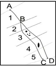
[image:4.595.174.453.561.696.2]Figure 7. A river was segmented into 5 segments and respectively described by corresponding types of SSMRCPs.
Based on the conditions above we could segment a river into several segments and best described by corres-ponding SMRCPs in detail which are illustrated in Figure 7. Segment 1 is correscorres-ponding to SSL, Segment 2 is corresponding to DSL, Segment 3 is corresponding to DSLMH, Segment 4 is corresponding to DSLSH, Seg-ment 5 is corresponding to DSL. However, the segSeg-ments can be suitable to be described by SMRCPs but the river may be segmented by other ways.
5. Conclusions
This paper proposed SMRCPs to describe the RCPs which are important for human beings. For describing the river in detail we proposed the segment conditions to segment the rivers. However, we just construct such spatial models idea, the method to express SMRCPs in computers should be developed in the future work.
Acknowledgements
The authors would like to sincerely thank the anonymous reviewers whose efforts significantly improved the quality of the research presented.
References
[1] Perillo, G.M.E., Pérez, D.E., Piccolo, M.C., Palma, E.D. and Cuadrado, D.G. (2005) Geomorphologic and Physical
Characteristics of a Human Impacted Estuary: Quequén Grande River Estuary, Argentina. Estuarine, Coastal and Shelf
Science, 62, 301-312. http://dx.doi.org/10.1016/j.ecss.2004.09.018
[2] Gregory, K.J. (2006) The Human Role in Changing River Channels. Geomorphology, 79, 172-191.
http://dx.doi.org/10.1016/j.geomorph.2006.06.018
[3] Billen, G., Garnier, J., Ficht, A. and Cun, C. (2001) Modeling the Response of Water Quality in the Seine River
Estu-ary to Human Activity in its Watershed over the Last 50 Years. Estuarie, 24, 977-993.
http://dx.doi.org/10.2307/1353011
[4] Zhang, J., Zhang, Z.F., Liu, S.M., Wu, Y., Xiong, H. and Chen, H.T. (1999) Human Impacts on the Large World
Riv-ers: Would the Changjiang (Yangtze River) Be an Illustration? Global Biogeochemical Cycles, 13, 1099-1105.
http://dx.doi.org/10.1029/1999GB900044
[5] Vanacker, V., Molina, A., Govers, G., Poesen, J., Dercon, G. and Deckers, S. (2005) River Channel Response to Short-
term Human-Induced Change in Landscape Connectivity in Andean Ecosystems. Geomorphology, 72, 340-353.
http://dx.doi.org/10.1016/j.geomorph.2005.05.013
[6] Leopold, L.B. and Wolman, M.G. (1957) River Channel Patterns, Braided, Meandering and Straight. U.S. Geol. Surv.
Paper. 282-B.
[7] Drury, G.H. (1969) Relation on Morphology to Runoff Frequency. In: Chorley, R.J., Ed., Water Soil and Man,
Me-thuen, London, 418-430.
[8] Birce, J.C. (1969) Planform Properties of Meandering River, River Meandering, Proceedings of the October. 1983.
Rivers “83 Conference”, ASCE, New Orleans. Louisiana, 1-15.
[9] Miall, A.D. (1997) A Review of the Braided River Depositional Environment. Earth Science Reviews, 13, 1-62.
http://dx.doi.org/10.1016/0012-8252(77)90055-1