Women Employee Security System using GPS And
GSM Based Vehicle Tracking
Poonam Bhilare
1,Akshay Mohite
2, Dhanashri Kamble
3, Swapnil Makode
4and
Rasika Kahane
51Professor,Department of Computer Engg.,Vishwakarma Institute Of Information Technology, Savitribai Phule Pune
University,Pune,India.
Student, Department of Computer Engg.,Vishwakarma Institute Of Information Technology, Savitribai Phule Pune University,Pune,India
2
3Student, Department of Computer Engg.,Vishwakarma Institute Of Information Technology, Savitribai Phule Pune
University,Pune,India
4Student, Department of Computer Engg.,Vishwakarma Institute Of Information Technology, Savitribai Phule Pune
University,Pune,India
5Student,Department of Computer Engg.,Vishwakarma Institute Of Information Technology, Savitribai Phule Pune
University,Pune,India
ABSTRACT
Women’s security is a critical issue in today’s world and its very much needed for every individual to be acting over such an issue. This paper describes a “GPS and GSM based vehicle tracking and women employee security system” that provides the combination of GPS device and specialized software to track the vehicle’s location as well as provide alerts and messages with an emergency button trigger. Now a days due to recently happened cases such as rape by drivers or colleagues, burglary etc., employee security, especially women employee security has become the foremost priority of the companies. System uses the Global Positioning System technology to find out the location of vehicle. The information of vehicle position provided by the device can be viewed on Google maps using Internet or specialized software. The IT companies are looking forward to the security problem and requires a system that will efficiently evaluate the problem of women employees security working in night shifts. This paper focuses on the proposed model that can be used to deal with the problem of security issue of women employees using GPS and GSM based vehicle tracking.
Keywords - GPS (Global Positioning System); GSM ( Global System for mobile); AVL ( Automatic vehicle location);
1. INTRODUCTION
The corporate and IT sector is the base of Indian economy and the base of the corporate and IT sector are the employees working for a company. Today, girl’s security is a major issue. Women in India have to face a lot of problems, especially professional women employees have to face lot of problems
while working for a company. Many physical harassment cases were revealed in recent years .It is company’s responsibility to look after their employee’s safety. Today, economic growth rate of country is increasing day by day and numbers of companies are establishing their setup in the country. The number of employees working for these companies needs an efficient and secure transportation facility.
Transportation facilities for these companies require huge amount of workload and complex infrastructure. Generally most of companies prefer local transport vendors on a yearly contract basis for the transportation of employees. But this is not the proper solution to the transportation and safety problem. Due to recently happened mishaps such as robbery and rape cases security for the women employees, has become number one priority for most of the companies. Most of the companies have security systems for employees but there are some serious drawbacks with those system as company cannot trust the drivers of transportation vehicles ,cost of system. In order to deal with such security problems, the system is proposed with innovative solution. This system will help to track the location of vehicle through using smart GPS device[1][2][3].
2. OVERVIEW OF THE SYSTEM
This proposed system is ‘GSM & GPS Based Vehicle Tracking and Women Employee Security System’. It consists of GPS device ie. Teltonika FM1100 [5] and an emergency button. GPS device must to be placed inside the vehicle. The device will provide the vehicle’s position information such as latitude, longitude of vehicle[2][4].An emergency button or panic button is fixed inside the vehicle at a particular position[10].Whenever an employee finds
himself/herself in any kind of trouble he or she will press the emergency button and an alert will be immediately sent to the company special team and nearby police station. Then it is the responsibility of police squad and company team to handle the situation. GPS device used is smart enough to get the inputs such as latitude, longitude & sends it using GSM SIM card
network operator [5].
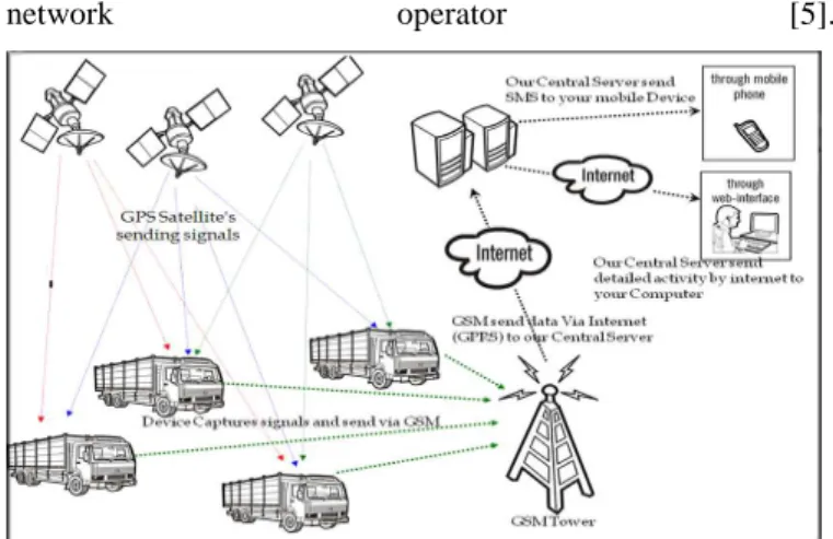
Fig. 1: Overview of the system
It is shown in Fig.1 [11] how the tracking device helps to find the appropriate position of the vehicle. The vehicle location information is in the form of latitude and longitude[4][7]. The device uses the GPS system to get the device co-ordinates. GPS device [5] which is incorporated in the vehicle unit gets the location information using satellites in the form of latitude and longitude real-time readings[5]. The device performs two main tasks. First to get the AVL device values and to transmit this data using GSM SIM card by SMS[5].For better transparency of the system an important feature is involved in the system is an emergency button. After pressing the panic button inside the vehicle ,an android device which is placed inside the vehicle captures images of inside view and sends to server and specific people The location of vehicle can be viewed on the Google maps[10].
3. PROPOSED SYSTEM
The system architecture is classified into vehicle unit, emergency button, company unit, android device and technical unit. Vehicle unit consist the vehicle, Teltonika FM 1100 device and one android device for each vehicle[5]. The company vehicle picks up the employees and drops the employees. Emergency button is a part of vehicle unit..The data received from the device is interpreted, processed and used by the technical system. The co-ordinates and the vehicle location is displayed using the Google maps interface[10]. The system architecture is shown in Fig.2. The system is divided into several parts. The vehicle unit, company unit, Teltonika GPS tracking device are the key features of the system.
Fig.3 Company Unit
Fig.3 shows the functionality of the company unit where the company’s emergency Team Leader gets the alert on the system and calls a rescue team of the organization to take necessary actions by going to the accident location and handle the situation at earliest.
3.1 Company Unit
The company unit consists of the special team to handle the emergency situation. As the company unit gets an alert and vehicle position details ,the unit goes over there and handle the situation.
3.2 Vehicle Unit
The vehicle is the company bus used to pick-up and drop employees. The system is also feasible for any kind of vehicle. The smart device Teltonika FM 1100 installation in necessary[5].Other wiring connections are to be made between the internal system of the vehicle and the GPS tracking device. A smart android device is placed inside the vehicle at such a position that it can take the camera pictures properly showing the inside view of the vehicle (bus).
3.2.1 Teltonika FM 1100 device
Fig.4 shows Teltonika FM1100 device[5].The Teltonika FM 1100 device is the vital part of the system. The installation of the Teltonika device in the vehicle is very important as the system completely relies on the data it gets from the device [5][7].
Fig.4 Teltonika FM1100
3.2.2 Android Device
The android device is used to enhance the reliability of the system. The android device is placed inside the vehicle to take the camera pictures of inside view of the system. In response to the action of pressing an emergency button by the employee the android device placed inside the vehicle takes the camera pictures of the inside view and sends it to the list of predefined cell phone numbers and mail-addresses registered with it. The android device with the good camera quality is preferred.
3.2.3 Emergency Button
The emergency button is part of the vehicle unit. Emergency button is very important facility provided to employees travelling by bus. The emergency button is connected to the digital pin of the Teltonika device. Emergency button is attached at a position that it should be easily available to employees in an emergency situation i.e. beside the chair, to the central pole. Employee can access it easily. On pressing an emergency button an alert message and the information regarding the exact location area of the vehicle is send to the nearest police station and company’s special team.
3.3 Technical Unit
System Components 3.3.1 GPS
The Global Positioning System (GPS) is a navigation and precise positioning tool Developed by the Department of Defense. Divided into six groups of four, each group is assigned a different orbital path to make sure that they can be detected from anywhere on the Earth's surface. The GPS system is used to track the company vehicle[2].
3.3.2 GSM
GSM stands for Global System for Mobile communication. It is digital mobile telephony system. The GSM SIM card is inserted inside the Teltonika FM1100 device to send and receive data using GPRS[5]. The GSM SIM card number is registered with the system. Another GSM SIM card is placed inside the android device which is placed inside the company vehicle. It is also used to send the message to the police station as well as company unit when employee is in emergency.
3.3.3 Geo-fencing
Geo-fencing is another feature which is highly customizable
and can detect wherever vehicle enters or leaves customized areas[8][9]. The system gives alert on entering or leaving a geo-fenced area[8][9]. This feature is also useful transportation company in case to restrict their vehicle drivers to travel from the sensitive zones. Geo-fencing (geo-fencing) is a feature in a software program that uses the global positioning system (GPS) to define geographical boundaries. It is a virtual barrier. Programs that incorporate geo-fencing allow an administrator to set up triggers so when a device enters (or exits) the boundaries defined by the administrator, a text message or email alert is sent [8] [9]. Geo-fencing applications incorporate Google Earth, allowing administrators to define boundaries on top of a satellite view of a specific geographical area. Other applications define boundaries by longitude and latitude.
3.3.4 Database and Alerts
The Database is retrieved each time when an alert is to be given. The database consists police station numbers and the geographical address of each and every police station involved in the system. The database also consists the cell-phone numbers of the company special team members. Text alert and ringing alert are generated using the AT commands[2]. We need just a modem and SIM card to carry out the action of generating the alert.
Alerts and the text information about the vehicle position area is send to the police station numbers and other necessary numbers. Also e-mail alerts are send to predefined e-mail addresses. On pressing an emergency button by employee in emergency situation, the android device inside the company bus takes images and send to the e-mail addresses and to the specified contact numbers.
3.3.5 AT commands
The text alert and ringing alert will be given using the AT commands and the modem. AT commands are instructions used to control a modem. AT is the abbreviation of ATtention. Every command line starts with "AT" or "at". That's why modem commands are called AT commands. Many of the commands that are used to control wired dial-up modems, such as ATD (Dial), ATA (Answer), ATH (Hook control) and
ATO (Return to online data state), are also supported by GSM/GPRS modems and mobile phones. Besides this common AT command set, GSM/GPRS modems and mobile phones support an AT command set that is specific to the GSM technology, which includes SMS-related commands like AT+CMGS (Send SMS message), AT+CMSS (Send SMS message from storage), AT+CMGL (List SMS messages) and AT+CMGR (Read SMS messages).
Example: ATD - This command is used to dial or call a number. System will dial police station number automatically when alert is to be generated.
Syntax: ATD<Phone number>;(Enter) For example,
ATD919876543210;
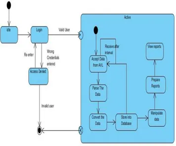
4. SYSTEM FLOW
The flow diagram of the proposed system is shown in Fig.5. Initially the Administrator log-in to the system. System performs the validation of administrator. An AVL (automatic vehicle locator) sends data to the server through GPS. System stores the data in the text files as it is. The data received is in hexadecimal numbering format. Parsing phase gets this data from the log files and performs analysis on the data and conversion phase converts this data in the decimal format. This updated data is then saved to the database. The given Fig.5.describes the flow of the proposed system.One terminal of the GPS device is connected to the ignition system of vehicle which gives the information of start and stop condition of the vehicle. In case of emergency employee will press the panic button and the alert is send.After pressing the panic button android device placed in the vehicle will capture the images and send. Geo fencing technique is used in this system
Fig 5. Flow Diagram Of system
. A Geo fence is a virtual perimeter on a geographic area using a location-based service, so that when the geo fencing device enters or exits the area, a notification is generated. The notification can contain information about the location of the device and might be sent to a mobile telephone or an email account. Geo fences are defined for particular areas. After pressing the panic button the alert will be send to the police stations which come under the defined geo fenced area.
4.1 Teltonika FM 1100 Device Functions
4.1.1 Get Data
FM1100 is a smart device with GPS and GSM connectivity. The device is able to determine the object’s coordinates and transfer them via the GSM network. The device uses the GPS technology. The takes the device co-ordinate at a fixed time interval and send it to the server at specified time interval. The device is also able to state the ignition system status and other important information .The device connection pins are connected to vehicle battery for power supply, emergency button, ignition button and other necessary parts. The connections with the vehicle should be done by a trained mechanic.
4.1.2 Send Data
The device sends the data at specified time interval using the network of the SIM card operator. A SIM card with GPRS connectivity is used for data transfer.
4.2 Data Processing Phases
The data received from the device goes through several phases: • Receive • Parse • Convert • Store Receive:
The data sent by the Teltonika device is received. The data is stored as it is in text files.
Parse:
The data received from the device is in Hexadecimal form. The data received is in the specific format and needs logical interpretation. This job is handled by the analysis phase of the system.The structure of the received data is shown.
Received data:
According to the structure as mentioned in [5] of the FM1100 protocol the data values are separated.
Eg. Stucture of data can be as shown :
080400000113fc208dff000f14f650209cca80006f00d60400040 004030101150316030001460000015d0000000113fc17610b00 0f14ffe0209cc580006e00c70500010004030101150316010001 460000015e0000000113fc284945000f150f00209cd200009501 080400000004030101150016030001460000015d0000000113 fc267c5b000f150a50209cccc000930068040000000403010115 0016030001460000015b0004
Covert to Decimal Format:
After the analysis phase the data needs to be converted from hexadecimal numbering format to the decimal numbering format. The data conversion helps in the further processing on the data. As the conversion is important part a simple hexadecimal to decimal conversion algorithm is used for the hexadecimal to decimal conversion process
Store:
The converted data in decimal format is used further for processing and report generation.
5.1 Installation
The proposed system uses the GPS device to get the information of the positions of the vehicle. This system uses the Teltonika FM1100.
The essential drivers are to be installed first for configuration of the device.
5.2 Configuration
The Teltonika FM1100 Configurator program is used for the configuration of FM1100.Necessary settings are done. Necessary values are entered as IMEI number and SIM card number.
5.3 PIN Connection
Necessary pin connections are done. The power supply pin of the device is connected with the vehicle battery.
Other digital input and output connections are carried.
Fig 6. Alert process
In Fig. 6 it is shown that the alerts and the text information about the vehicle area are send to the police station numbers and other necessary numbers. Also e-mail alerts are send to predefined e-mail addresses on pressing emergency button by employee in emergency situation. The camera images taken by android device inside the company bus are also send to the e-mail address.
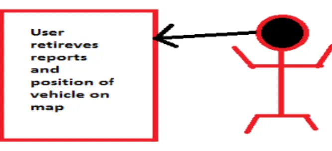
Fig.7 Retrieving reports
Fig.7 Shows user can see reports and vehicle location on map. The user can see the reports of vehicle speed, ignition status and travelling report[5]. An internet connection is necessary for reading the vehicle information and the reports of the tracking.
A strong communication network is necessary for maintaining the efficiency of the system[3][6].
Tracing Location On the Map
System user can see the vehicle position. The user can see the reports of vehicle speed, ignition status and travelling report. The user must enter the username and password provided at the time of authentication. An internet connection is necessary for reading the vehicle information and the reports of the tracking. A strong communication network is necessary for maintaining the efficiency of the system. To show tracking of the vehicle and position Google maps system is used[10]. An appropriate geographical location is plotted on the basis of available coordinates This will help company unit and police to trace the vehicle. Fig.8 shows how the location will be given by system on Google Map API.
6. CONCLUSION
In today’s world girl’s security is a major issue. This system will help provide security to the working women by using alerts and emergency buttons in order to avoid any hurdles faces by them. Existing systems provide the mechanism to track the vehicle but still there is no separate mechanism to provide security to women employee. Such vehicle tracking system is extended with alert messages and panic button by our proposed model to overcome the problem of women employee’s security that can be implemented for companies which have large number of women employees working in night shifts and by the companies which are situated away from the residential places. Following features like panic button to generate alarm and send message to the system, capturing images by connecting an android device in vehicle and sending the pictures on trigger of panic button, provision of location of vehicle after fix time interval, viewing location of vehicle on google maps which is easily available are the power planer of proposed model but still providing security seamlessly at any time without any functional or physical device failure interventions remains a future issue that needs to be resolved.
REFERENCES
[1] A Car Test for the Estimation of GPS/INS Alignment Errors Sinpyo Hong, Man Hyung Lee, Senior Member, IEEE, Sun Hong Kwon, and Ho Hwan Chun IEEE
TRANSACTIONS ON INTELLIGENT
TRANSPORTATION SYSTEMS, VOL. 5, NO. 3, SEPTEMBER 2004.
[2] GSM and GPS based Vehicle Location and Tracking System - Baburao Kodavati,V.K.Raju, S.Srinivasa Rao, A.V.Prabu, T.Appa Rao,Dr.Y.V.Narayana, International Journal of Engineering Research and Applications (IJERA) ISSN: 2248-9622 www.ijera.com Vol. 1, Issue 3, pp.616-625
[3] Velocity based Tracking and Localization System using Smartphones with GPS and GPRS/3G Ibrahim Abdallah Hag Eltoum , Mohammed Bouhorma Department of Computer Engineering, Laboratory of the Computer
System and Telecommunication "LCST" FST, Abdelmalek Essaadi University, Tanger, Morocco. [4] POSITIONING AND NAVIGATION SYSTEM USING
GPS J.Parthasarathy International Archives of the Photogrammetry, Remote Sensing and Spatial Information Science, Volume XXXVI, Part 6, Tokyo Japan 2006.
[5] FM1100-user-manual v1.23
[6] Francis Enejo Idachaba “Design of a GPS/GSM based tracker for the location of stolen items and kidnapped or missing persons in NIGERIA”ARPN Journal of Engineering and Applied Sciences VOL. 6, NO. 10, OCTOBER 2011
[7] FMXXXX protocol
[8] Edge-Based Locality Sensitive Hashing for Efficient Geo-Fencing Application Yi Yu, Roger Zimmermann School of Computing, National University of Singapore Singapore 117417 [email protected]
[9] http://en.wikipedia.org/wiki/Geofence.
[10] GPS and GSM based Vehicle Tracing and Employee Security System - S.S. Pethakar ,N. Srivastava S.D.Suryawanshi- Bharati Vidyapeeth Unv.Pune , Pune-Satara road Pune 411043
[11] http://unicindia.wordpress.com/category/vehicle-tracking-devices/