USE OF MODERN TOPOGRAPHICAL EQUIPMENT FOR DRAW UP THE
TECHNICAL DOCUMENTATION FOR REHABILITATION OF COUNTY
ROAD 643 C HOREZU - DOBRETU, OLT COUNTY
CROITORU A., CĂLINA JENICA, MILUȚ M., CROITORU IRINA
University of Craiova, Faculty of Agronomy
Key words: modern topographical instrument, measurements, road rehabilitation
ABSTRACT
The paper aim is to achieve the situation plan ecessary for design and carrying out the work rehabilitation of county road 643C-Dobretu Horezu, Olt County.
The works were executed in the 1970 Stereographic projection system and Black Sea 1975 (for altitudes), using Leica GPS GS 09 and total station LEICA TS 06. With Leica GPS System 09 GS using quick cinematic method (RTK) were determined support points and details on the area, also, using total station LEICA TS 06 has been made a supported traverse with polar coordinates method for thickening the network and surveying planimetric details. In the present case these were considered the most accurate types of measurements that can be applied for surveying the details of the studied area, an area characterized by a part covered by vegetation and personal residences where it was used method of supported traverse, and part free of obstructions where it was used the real time kinematic method (RTK).
INTRODUCTION
The concerned real estate is located in the incorporated and non-incorporated area of Dobretu, Olt county, being used as a county road. At an administrative level, the commune includes three villages: Dobretu, the commune residence, located to the North, along DJ 643C, Horezu, located to the South, along DJ 643C, and Curtisoara, located in the centre of the commune.
WORK METOHDS
The works required for drawing up the technical documentation were performed in the Stereographic 1970 projection system, Black Sea 1975 reference, with a GPS Leice GS 09 and a total station LEICA TC 06.
The GPS Leica GS 09 system helped create a density enhancement network including four points, from which, by means of the LEICA TS 06 total station, a supported road was built for network enhancement and planimetric detail elevation. At the same time, the area details were elevated through the real time kinematic method (RTK), by means of the GPS Leica GS 09 system.
In the hereby case, the most accurate types of measurements were considered that can be applied to elevate the details of the studied area, which is characterized by a part covered by vegetation and personal residences, where the supported road method was used for elevation, and a free part, whereby the real time kinematic method (RTK) was used for detail elevation.
The GPS Leica GS 09 system may be used in a wide variety of operating modes, providing a full topographic system. Using only SmartAntenna GS09 and the CS09 controller, combined with the corresponding accessories, various operating modes are provided. The SmartWorx software controller is based on the Leica System 1200 familiar concept (fig. 1).
RTK Rover - low weight and no cables, is easy to use along an entire day. Built with exceptional solidity, RTK rover can stand use in hard working conditions and falls. The easy setting of an RTK reference station only needs the SmartAntenna GS09, the radio modem and a battery. Statistical measurements may be performed and raw data may be collected by adding the CS09 controller.
Fig. 1. GPS Leica GS 09 system
The ROMPOS - Leica GS09 network rover operates perfectly in any permanent station network. Network corrections are received through GSM/CDMA modems or by using a mobile phone.
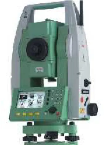
The Leica TS 06total station manufactured byLeica Geosystems is a high quality total electronic station (fig. 2)
The used technology helps ease work in daily activities. The tool is ideal for topographic elevation and tracing works. The functions of the tool can be learned easily in very short time.
Fig. 2. Leica TS 06 total station
The technical features ofLeica TS 06for angle measurement are as follows: - standard deviation TS 06 – 1 mgon (3”);
- quadruple electronic compensator;
- compensator accuracy TS 06 – 0.5” (0.05 gon) - zoom – 30x;
- minimum target distance 1.7 m; - illuminated reticleș
The technical features of the tool for distance measurement are as follows: - measurement distance with a circular prism – 1500 m in difficult conditions; - standard deviation – 1.5 mm + 2 ppm;
- time required for the measurement – < 1 s; Other technical data:
- internal memory – 100000 data blocks (external memory - card or USB); - black and white display - 160x288 pixel resolution;
- laser centering accuracy – 1.5 cm at a 1.5 m height; - usage temperature - -20° up to +50°;
- resistance to humidity and rain protection; - total weight 5.2 kg.
RESULTS AND DISCUSSIONS
After the land was recognized and the points in the density enhancement network were marked and signalled, coordinates were determined by means of four points in the density enhancement network (0001, 0002, 0003, 0004) with the GPS GNSS Leica GS 09 system. Points were determined by RTK (Real Time Kinematic), a quick and accurate method. In order to receive differential corrections, the GPS GNSS Leica GS 09 system was connected to the Slatina (SLTN) permanent station, a point known from the A class public geodesic network, named according to Leica Ref 0056. The distance between the reference station and newly determined points falls within the maximum distance recommended through this method, i.e. 50 km.
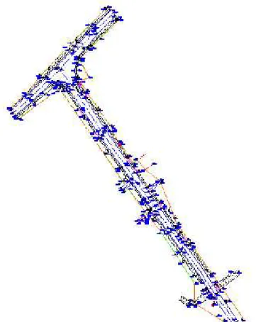
A total LEICA TS 06 station was used to achieve measurements through the classical method. Stationing took place in the known point 0002, with orientation on the known point 0001, new elevation points S3 and S4 were determined and road creation was closed in the known point 0004 with orientation on the known point 0003 (fig. 3). Details such as: carriage way limit, carriage way hub, ditch limit, ditch hub, construction limit, fence limit, electrical poles, sewerage network, trees, etc. were removed from the four road creation stations.
The 4 points determined through GPS technology have the coordinates presented in table 1.
Table 1.
Inventory of coordinates for old points
Point
X (m) Y (m)
name
0001 332288,883 416087,878 0002 332304,700 416108,618 0003 332068,723 416237,610 0004 332072,274 416245,147
The site data was processed with specialized software, resulting in the coordinates of road planning points (table 2.).
Table 2. Inventory of coordinates for new points
Point
no. X (m) Y (m)
S3 332174.220 416163.917 S4 332111.760 416213.757
Planimetric details were elevated from the station points determined upon road planning, through the radiation method. The coordinates of radiation points were determined after the performance of calculations.
Based on rectangular coordinates, the location and delimitation plan was drawn up at a 1:500 scale, on 7 A0 sheets of paper. A fragment thereof is presented (fig. 3), because of the size.
CALCULATION OF SURFACES
The analytic method was used for surface calculation, i.e. the most accurate calculation method.
Having the absolute coordinates of points, the surface was calculated using one of the following calculation formulae:
2S = ( 1 1). 1
n nn
n
n Y Y
X 2S = ( 1 1).
1
n nn
n
n Y Y
X
The measured surface is used as a road and is 56,307.00 sqm.
CONCLUSIONS
1. The purpose of the work is to draw up the location plan for the design and performance of modernisation works on the 643C county road, Horezu-Dobretu, county of Olt.
2. The works required for drawing up the technical documentation were performed in the Stereographic 1970 projection system, Black Sea 1975 reference, with a GPS Leice GS 09 and a total station LEICA TC 06.
3. The GPS Leica GS 09 system helped create a density enhancement network including four points, from which, by means of the LEICA TS 06 total station, a supported road was built for network enhancement and planimetric detail elevation. At the same time, the area details were elevated through the real time kinematic method (RTK), by means of the GPS Leica GS 09 system.
BIBLIOGRAPHY
1. Călina A. şi colab. – Topografie generală şi inginerească, Ed. Sitech, Craiova, 2005;
2. Călina Aurel, Călina Jenica, Miluț Marius, Croitoru Alin, Ionică Cristian Study on preparation of technical documentation required to design road dc 36 upgrading -stanesti-stoilesti, valcea county, Analele Universităţii din Craiova, seria Agricultură-Montanologie-Cadastru, vol XLIV/2, 2014, Ed. Universitaria, Craiova, pag. 35-41, ISSN 1841-8317, revistă indexată în bazele de date Index Copernicus, Ulrichs, CABI, DOAJ.
3. Călina Jenica, Călina Aurel, Croitoru Alin - Topographical works used in achievement of feasibility study for rehabilitation and modernization of the Agigea Bridge, Analele Universităţii din Craiova, seria Agricultură-Montanologie-Cadastru, vol XLII/2, 2012, Ed. Universitaria, Craiova, pag. 316-320, ISSN 1841-8317, revistă indexată în bazele de date Index Copernicus, Ulrichs, CABI, DOAJ.
4.http://www.geoserving.ro/sisteme-gnss-gps/leica-gs09