Distributed hydrological model application for
estimating the groundwater resource at Cu De
river catchment, Viet Nam
Ngoc Duong VO
1,2, Quang Binh NGUYEN
1, Philippe GOURBESVILLE
2 1 Faculty of Water Resource Engineering,University of Science and Technology, the University of Da Nang, Viet Nam.
2 Innovative City lab URE 005
Polytech’Nice Sophia, Nice Sophia Antipolis University, France.
[email protected]; [email protected]; [email protected]
Abstract
Groundwater is a fundamental component in the water balance of any watershed. It affects considerably on flow regime, especially on base flow. However, it is not easy to survey this component, notably towards the lack of data catchment and developping countries. This study is to present a new approach to overcome the limitation in simulating the ground water. By using the deterministic distributed hydrological model, the study is hope to provide basic information about ground water for a catchment in Vietnam coastal central region, Cu De river catchment. The modelling is realized for an area of 425.2 km2 in period of 2006 – 2010. The results are analyzed in many aspects such as: groundwater spatial distribution, groundwater flow process, groundwater storage, and groundwater recharged volume.
Keywords: Cu De river catchment; Groundwater spatial distribution; Groundwater flow process; Groundwater recharged volume; Deterministic distributed hydrological.
1
Introduction
Groundwater is a fundamental component in the water balance of any watershed. It affects considerably on flow regime, especially on base flow. However, it is not easy to survey this component, notably towards the lack of data catchment and developping countries. This study is to present a new approach to overcome the limitation in simulating the ground water. By using the deterministic distributed hydrological model, the study is hope to provide basic information about ground water for a catchment in Vietnam coastal central region, Cu De river catchment.
2
Study area
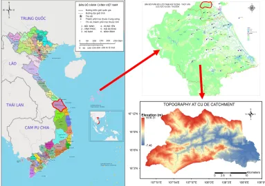
The Cu De is second largest river and is one of main supplied water resource of Da Nang city. It covers an area up to 425.2km2 (Figure 1). This is located at the edge of the largest rainfall region Quang
Nam - Da Nang.
The catchment’s average annual rainfall is quite high, approximately 1800 mm. However, there is a difference in the season, 65%-80% of annual rainfall concentrated in the period August - December. Moreover, this area is under attack every year from 2 - 4 storm bringing heavy rains and whirlwinds (To, 2005). This severe weather pattern makes the natural disaster occurs frequently and seriously.
Figure 1: Cu de catchment
3
Methodology
The proposal method presented in this study is:
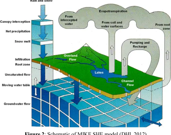
The first step, applying a distributed deterministic hydrological model – MIKE SHE which was developped by (Duong, Binh, Ma, & Gourbesville, 2016) for simulating the hydrolocal process in Cu De catchment. This model covers the major processes in hydrologic cycle including rainfall, evapo-transpiration, overland flow, unsaturated flow, groundwater flow, channel flow, and their interactions is expected to give an overall about the hydrology of the catchment, including groundwater. The second step is to analyze the modelling result for assessing the groundwater resource and proposing the solution to extract more reasonable.
The proposal method presented in this study is:
Figure 2: Schematic of MIKE SHE model (DHI, 2012)
The proposed principle for Cu De river’s flow reproduction is based on the similar of its catchment characteristic with another one and on the deterministic distributed model as sheme in Figure 3.
Figure 3: Proposed methodology for steam flow reproduction
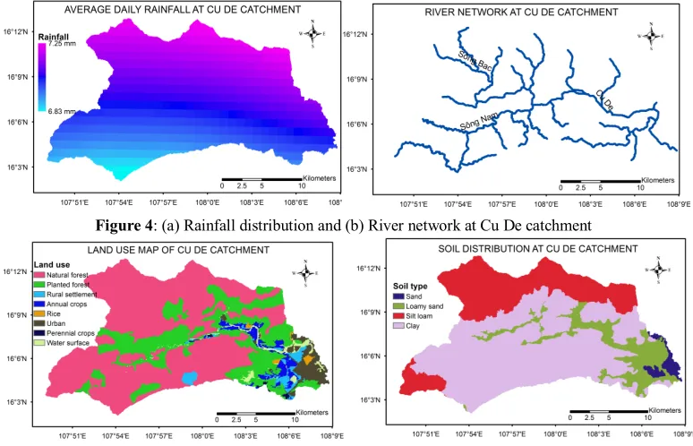
In this study, the model is set up over an area of 425.2 Km2 and includes all of hydrological
Figure 4: (a) Rainfall distribution and (b) River network at Cu De catchment
Figure 5: (a) Land use map and (b) Soil map at Cu De catchment
4
Results and Discussion
4.1
Model validation
The model is run in period of 5 years, from 2006 to 2010 with hourly rainfall data. In order to overcome the difficulty in model validation, reproduced flow is compared with flow module of past studies at Nam O bridge station. The comparison is showed in the Table 1, Figure 6, Figure 7 and Figure 8. The model result is seemly reasonable and acceptable in comparison with two last studies of CVIWR (2015), Nguyen (2005) and flow module of two stations (Nong Son, Thanh My) of neighboring catchment (Vu Gia Thu Bon) ( Vu et al., 2011). The annual value, seasonal values of simulated flow seemly catch the values in result of Nguyen (2005).
Table 1: Flow module comparion
Study catchment Reference catchment RCCWRDN
project
Nguyen
(2005) Simulation Vu Gia Thu Bon Dry season 44.7 21 23.5 32.4 36.1 Flood season 229.9 120 161.1 162 233 Annual average 91 45.75 69.4 71.2 92.4
4.2
Groundwater analysis
By advantage of MIKE SHE model, the groundwater is extracted and analyzed over Cu De catchment. The analysis is realized in different aspects: Groundwater distribution, surface and ground water exhange.
4.2.1
Groundwater distribution
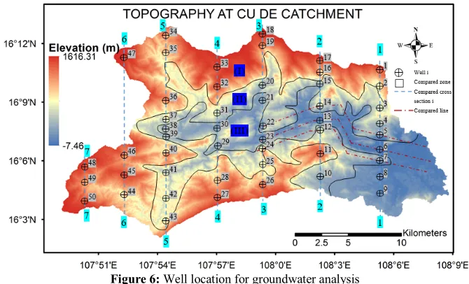
Groundwater distribution in Cu De is considered by the change according to atltitude: three area is defined: mountainous area (I) is representative for area which have the altitude higher than 538 m, midland area (II) is for area which the altitude is from 255m to 538m, lowland and coastal area (III) is for area which is lower than 255 m. The head elevation in saturated zone at fifty wells over three area will be analyzed. The well loction is presented in Figure 6.
Figure 6: Well location for groundwater analysis
Figure 8: Head elevation stored in saturated zone, 01/2007
The results in figure 8 also show the saturated zone flow distribution. Following that, the saturated zone flow concentrates much in mountainous area, especially in left side of Cu de river, and at neighbouring area of large stream branches (Figure 4b).
4.2.2
Surface and groundwater exchange
The interaction between surface and groundwater are complex. However, the exchange between these components plays an important role in hydrological process of catchment. Analyzing the surface and groundwter exchange is necessary for getting more knowledge on groundwater distribution. In Cu de catchment, along the large stream and mountainous area are judged to be the principal recharged source for groundwater (Figure 9). These are the main sources for maintaining the Cu De flow river in drought season.
Figure 9: Total discharge rechanging to saturated zone
5
Conclusions
The study aims to look for a new way to study the groundwater in lack of data catchment. By exploiting the advantage of deterministic distributed model and the result in neighboring catchment, the Cu De river’s hydrological process is reproduced. By taking into account the unsaturated and saturated zoene’s flow process, the simulation also brings out results related to groundwater resource of the catchment. The result provides an overview about the groundwater distribution in Cu De catchment. Futhermore, the exchange between surface and ground water is expressed in the paper.
References
CVIWR. (2015). Comprehensive assessment towards a resistance with the climate change on water resources Da Nang city.
DHI. (2012). MIKE SHE User’s Manual. (M. by DHI, Ed.) (Mike by DH).
Duong, V. N., Binh, N. Q., Ma, Q., & Gourbesville, P. (2016). Applying Deterministic Distributed Hydrological Model for Stream Flow Data Reproduction. A Case Study of Cu De Catchment, Vietnam.
Procedia Engineering, 154, 1010–1017.
Nguyen, T. S. (2005). Vietnam Water Resource Assessment - Đánh Giá Tài Nguyên Nước Việt Nam. NXB GIÁO DỤC.
TO, T. N. (2005). Strategic plan for integrated water resources management of the Vu Gia Thu Bon Basin Organization.