49 Available online at www.ijiere.com
International Journal of Innovative and Emerging
Research in Engineering
e-ISSN: 2394 - 3343 p-ISSN: 2394 - 5494
Study of Flash Floods
Mr. U. M. Dhurve
1, Dr. S. R. Asati
21 B.E Scholar, M.I.E.T, Gondia 2 Head of the department, M.I.E.T, Gondia
ABSTRACT
Flash floods are being commonly observed in many parts of world and India is not untouched. Heavy loss of life and infrastructure occurs during its occurrence. In this paper, a detailed survey of sites damaged due to flash floods in Uttarakhand (2013) and had a case study to mitigate its impact on society. This paper describes best to let the scientific world know the cause and impact of flash floods. This could help mankind to better get prepare for such natural disasters. Further improvement in this project is needed.
Keywords: Flash floods, mitigate, cause, impacts
I. INTRODUCTION
A flash flood is a rapid flooding of geomorphic low-lying areas: washes, rivers, dry lakes and basins. It may be caused by heavy rain associated with a severe thunderstorm, hurricane, tropical storm, or melt water from ice or snow flowing over ice sheets or snowfields. Flash floods are distinguished from a regular flood by a timescale of less than six hours. The temporary availability of water is often utilized by foliage with rapid germination and short growth cycle, and by specially adapted animal life
Flash floods are usually resulting from intense storms dropping large amounts of rains within a brief period depending on local terrain. Groundcover, degree of man made changes to river banks and initial ground or river conditions. Flash floods occur with little or no warning and can reach full peak in only a few minutes. Flash floods occur within six hrs of a rain event, or after a dam failure or, following a sudden release of water held by an ice or debris.
Flash flood waters move at very fast speeds and can roll boulders, tear out trees, destroy buildings and obliterate bridges. As land is converted from fields or woodlands to roads and parking lots, it loses its ability to rainfall. Urbanization increases runoff two to six times over what would occur on natural terrain. In further chapters we will go in brief about the same to carry out the economical, safe and beneficial solution over it for the betterment of the living as well as non living things.
II. AREASAFFECTEDBYFLASHFLOODS
50 Fig 2.1: Areas affected by flash floods [6]
Some Flash floods during 2005 to 2013 are occurred in India which are:
Mumbai: On 26th July 2005, a cloudburst caused approximately 950mm of rainfall on Mumbai. Over a span of 8-10 hours it badly affected the financial capital of the country. In this 1000 people lost their lives.
Pune: On 29 September 2010 a cloudburst in NDA, Khadakwasla occurred. These cloudburst left many injured, hundreds of buildings, vehicle got damaged due to this flash flood.
Pashan: On 4thOctober 2010, a cloudburst in Pashan, Pune took place. The rainfall intensity and quantity of these cloud burst recorded by the city was too high. These left 4 people deeds.
Himalayan Flash Floods: Himalayan flash floods are the floods that occurred on the midnight of 3rd August 2012 in the Himalayan region of Northern Indian states. The flash flood was the result of the cloudburst which also triggered landslides. Areas affected include Uttarkashi, Garhwali, Palchan, Moradabad and Kathua. 31 people lost their lives. Nearly 2000 people were affected by these floods.
Kedarnath Floods: Duration of the flood was 14th – 17th June 2013. The adjoining areas received a heavy rainfall, which was about 375% more than the benchmark rainfall during a normal monsoon. This caused the melting of Chorabari Glacier at the height of 3800 meters and eruption of river Mandakini which led to heavy floods. Areas affected where India (Uttarakhand, Himachal Pradesh, Uttar Pradesh), Nepal (far Western and mid Western region). Around 5700 people lost their lives. [6]
III.NEEDTOSTUDYFLASHFLOODS
Flash floods have been nuisance to many countries for decades. The rapidity at which it occurs makes prediction very difficult. As a result, an early warning system may not be the desired approach since flooding of this nature may occur before it reaches the intended group of people who are affected. Therefore, preparation for unexpected flood scenario is important.
No matter what the place is nor it matters to the wish of the demographic establishment. Floods have been a regular phenomenon not only in our country but also in foreign nations. Recent flood in Thames River in London is an excellent example of it. The technological angel called popularly “Thames Wall” proved identical to convert the flash flood of Thames into a normal flood. Such precaution could be taken because they showed interest in studying the floods in recent past.
Flooding from various scenarios covered a wide extent of areas along the river; the next step involved the identification of emergency shelters and the shortest route to them. While none of the shelters where allocated for the people at risk were inundated, two were at risk of being flooded. The next step involved the analysis of the perception survey.
Due to the various fatalities and economic damages imposed by flood events in various countries around the world, the Commission of European Countries (CEC) has realized the importance of mitigating the catastrophic impact a flood of a given magnitude may have on the vulnerable population. It is with this framework in mind that The CEC developed a proposal for flood directive which aims at reducing and managing the impacts floods may pose o properties, human health and the environment. This approach includes the perception of risk by the public, decision makers and the study of spatial planning. Following this assessment, flood hazard maps will be made and risk management plans must be developed. It aims to include all aspects of the risk cycle and will place emphasis on prevention, protection and preparedness. [3]
51 a given result period may occur and will include an assessment of the number of inhabitants and type of economic activity that will be affected.
There is the need for a study that is based on different flood scenarios that will take into account overtopping, breach, damming of the river system. Since the area is already prone to multiple-hazards, an evaluation of the current preparedness plan is also needed in the event there is a disaster that the current preparedness plan did not take into account of. This information could be useful for spatial planning.
IV.STUDYOFFLASHFLOODSINHIMALYANTERRAIN:
The dusk was at its final point when we reached Agystmuni which was 51 km away from kedarnath. It was a small town with so many small villages around it. We resided in the hotel named Hotel Monica which was advised by our driver as it was the only hotel that was unaffected during the crucial period for kedarnath. The hotel was at Shyalchangrabdri a small village around Agystmuni. The hotel’s owner was an old couple residing there from approximately 40 - 45 years. After getting refreshed we had an interview with the old lady and the workers of the hotel. The information we got from local people is as follows: Kedarnath which is a holy place and also a dream for the old age people to visit the char dham yatra of which the kedarnath is one of the dham. The old people’s population is accepted to be there but from last 20 years the population consists of gerents, newly married couples, small kids which even don’t know the meaning of dham use to come. This has increased the tourist ratio as compared to the past years. Excess tourist results in the imbalance of nature which can cause a devastating crisis. The load and the ratio of effluents increases as the tourist use the vehicles to reach upto Gaurikund which is 14 km from kedarnath. This causes disturbances in the nature cycle.
Fig 4.1: Excess traffic and tourist
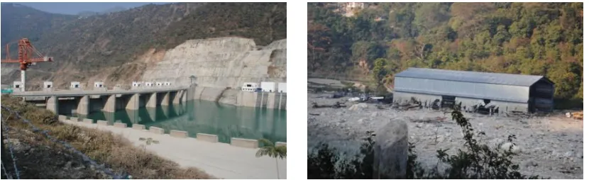
The other reason was the construction of hydro projects to produce electricity. They told that in the small state of Uttarakhand there are 256 projects to be carried out which are constructed, under construction and under planned. One can imagine how devastating it could be. For constructing dams the first step is the cutting down of trees and following to it the blasting. These factors are the major to disturb the ecological cycle of nature.
After deforestation when the rainfall occurs this increases the runoff also most of the water penetrates into the soil which results in loosening of the interbonding strength of soil particles. This results in landslides. The same is during the blasting. It has been proved that the Himalayas are fragile as there heights are increasing day- by- day due to stacking of tectonic plates. The major dam has been constructed in kund which was around 10 km from the place where we resided. This disturbed the erosional work of river. So, the blasting is very dangerous to be carried out in such areas. Also, Uttarakhand state occurs in the 5th zone of earthquake prone areas.
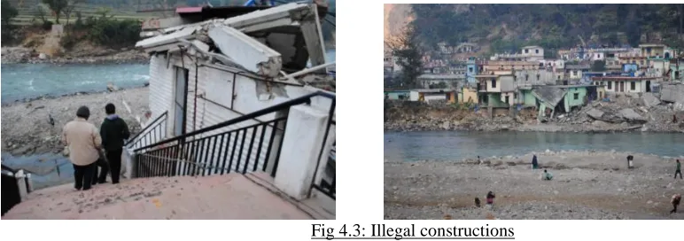
52 After that they told us about the illegal construction that has been carried here from last few years as the percentages of tourist have been increased. The local peoples don’t get land easily as it is hilly areas so they used to construct hotels, houses etc. on the banks of the river. This is due to the covetous nature of people so as to become rich. They don’t follow the specification of the town planning and just carry out construction with the help of local people which don’t know even the meaning of civil engineering. When the river flows with its full velocity it won’t get the area to carry out its meandering procedure and as a result of which the structure comes across of its way are wiped out and the people blamed the nature for this. They told us approximately 50,000 lives have been wiped out during the crisis. The 3 hotels named Priyadarshini, Om lodge and Rudraksh lodge have been totally wiped out. The figure shows the status:
Fig 4.3: Illegal constructions
V. SYNOPTICFEATURESASOBSERVEDDURING17-18JUNE2013
Some major synoptic features observed on the 17th and 18th of June 2013 were taken from the weekly weather watch issued by the India Meteorological Department on the 19th of June 2013 and are listed below: -
The axis of monsoon trough was seen to be passing through Bikaner, Gwalior, Gaya and Imphal and across the Gangetic West Bengal.
A low pressure area which originated over northwest Bay of Bengal moved eastwards and was seen over Odisha on 13th June. It intensified into a well marked low pressure area. This system sustained its northwestward movement till 18th June and weakened into a cyclonic circulation over Haryana and adjoining west Uttar Pradesh.
A western disturbance (WD) in the form of a trough in mid tropospheric level was observed around west Rajasthan on 16th June.
The areas of Uttarakhand affected by the recent floods, particularly Uttarkashi, have experienced excess rains in June for the past several years. Last year, there was a rainfall deficit in the same month across the state. But data for the preceding five years indicates a trend towards excess rainfall in June.
District-wise rainfall trends in Uttarakhand from 2008 to 2012
Chamoli Rudraprayag Uttarkashi
R/F* % departure from
LPA# R/F*
% departure from
LPA# R/F*
% departure from LPA#
2008 163.8 59 148.9 -30 298.3 98
2009 32.2 -69 17.8 -92 197.3 31
2010 121.8 18 166.6 -21 189.9 26
2011 170.5 57 369.6 70 363.7 146
2012 41.1 -62 95.4 -56 45.6 -69
*Rainfall
53 Table 5.1: Rainfall data of 5 consecutive years [1]
In 2011, Uttarkashi received 146 per cent excess rainfall compared to the long period average (LPA). The corresponding figures for 2010, 2009 and 2008 are 26 per cent, 31 per cent and 98 per cent. Chamoli received 57 per cent excess rainfall in June in 2011, 18 per cent in 2010 and 59 per cent in 2008.Rudraprayag also received a deficit rainfall in 2008, 2009, 2010 and 2012, but the year 2011 witnessed excess rainfall of 70 per cent. [1]
VI.EFFECTS
June 16th and 17th of 2013 will be considered the darkest days in the history of Uttarakhand, when unprecedented rain led to the disaster which affected the whole Uttarakhand, and brought the life in the state at halt. The situation was even worse in 4 districts of the state namely: Rudraprayag, ChamoliGarhwal, Uttarkashi and Pithoragarh all border districts of Uttarakhand. The people there were in a greater trouble as several places were became islands as all the connections with rest of the country was broken. There was no electricity no mobile signal nothing.
At that time several towns were became ghost towns. There were debris all around and bad smell of rotting human and animals bodies. Due to the unprecedented rains for a period of 2-3 days in Uttarakhand resulted into the Landslides and finally to the floods, damaged several houses and structures, killing the pilgrims as well as local people those who were trapped. The heavy rains resulted in large flashfloods and massive landslides. Entire villages and settlements such as Gaurikund, and Ram Bada, have been wiped out almost completely, while the Sonprayag suffered heavy damage and loss of lives.
Starting from Kedarnath, Rambara, GauriKund, GauriGaon, Mundkatiya, Sonprayag, Sitapur, Rampur, Badasu, Kalimath, Kund, Kakda, Ginwani, Bheeri, Syalsor, Chandrapuri, GavniGaon, Sori, Bedubagar, Ganganagar, Jawahar Nagar, PuranaDeval, Vijay Nagar, Agastyamuni, Silli, Rampur, Tilwara, BhatwariSain, Rudraprayag, Srinagar, Devprayag and till Rishikesh flood did immeasurable damage. More than dozen village of Kalimathvalleys were also completely isolated after the bridges were washed away.
Chardham the pilgrimage centers in the region including Gangotri, Yamunotri, Kedarnath and Badrinath are visited by thousands of devotees, especially after the month of May onwards. Over 90,000 people were stranded in various places because of damaged or blocked roads. Thousands of people lost their life and more than 90000 people were stranded for more than a week in the mountains and struggled for life. Some of them could not cope with the situation and left the world. In Kedar valley alone in several villages most of the men were reported missing as they were working in Kedar valley during the Yatra. About 5760 people are reported dead by the government of Uttarakhand. Only from the Okhimath tehsil 176 school going children became the victim of the disaster. Many people of the village Divli-Bhanigaon, Lwani, Bamsu, Lwara, Lamgondi, Andrwadi, Phali, Pasalt, Gaurigaon, Mundkatia especially men were reported missing. Official figures however differ significantly with the figures given by the local people. [2]
VII. PREVENTIVEMEASURES:
A. Infrastructural Planning In Flood Affected Region
From North to South and from east to west, the constructional planning of various regions in India differs from each other. The kind of building found in south and that of north are of distinct characteristics. There are ample parameters which state the nature of such monuments. The demographic pattern of people living in the region, the constructional practice of the engineers in the region decides the nature of monuments. [5]
Fig 7.1: Ineffective infrastructural planning
B. PREVENTING LANDSLIDES
54 a. Plant vegetation: Plantation is the measure factor for controlling the landslides because the roots of the plants grasp the particles of the soils with full grip. This will help in controlling the loosen of interbonding strength between particles of the soil as a result of which the landslides will in control.
b. Control water run-off: As the rain water is divided into 3 major factors i.e Runoff, evaporation, percolation. The runoff and percolation are the two major factors for the landslides. The percolation can be controlled by planting the trees and the runoff can be controlled by constructing the trenches beneath the road surface so that it will create the path for runoff to directly meet into the banks of the river. This will result in controlling the landslides.
c. Retaining wall: By constructing the retaining wall the landslides can be control. below.
Fig 7.2: Retaining wall to control landslides
d. By building chicken nets: Chicken nets can be helpful in controlling the landslides as it grips the soil particles and boulders with full power like holding the bunch of sticks in the hand with full grip. This will enable the strata to loosen up the interbonding strength and will decrease the chances of the landslides
Fig 7.3: chicken nets to control landslides C.AFFORESTATION:
Afforestation is the process of establishing a forest on land that is not a forest, or has not been a forest for a long time by planting trees or their seeds. The term may also be applied to the legal conversion of land into the status of forest.
D. EFFECTIVE DRAINAGE SYSTEM:
Uttarakhand is a small state which lies in the Himalayan region which is fragile in nature. For every region where live hoods and occupation are there should consists of effective drainage system. The kind of drainage system decides the development pattern of the concerned area. Proper drainage ensures good health and life expectancy of demograph. [5]
VIII. TOWNPLANNINGASPERCLIMATEPATTERNOFREGION:-
One of the important points that we concluded throughout our case-study is that the major cause for this disaster was lack in town-planning of the area. To increase the tourism roads are constructed at a very rapid pace irrespective of their proper structural designs. As the roads have to bear constant heavy loads of public vehicles like buses and all its important that the roads are designed keeping in view that it do not get collapse within short span by using good quality materials in proper ratio. For making a river improvement plan, it is recommended to make a discussion in reference to the following values given in Table
Design Flood
Discharge Cu.m/sec
River width (M)
300 40-60
500 60-80
1000 90-120
2000 160-220
5000 350-450
55 The above table illustrates the minimum width of River for the typical discharge of water. When the width of river is less than the prescribed for the given discharges then the flood water starts coming to the respective flood plains. In this way it enters the habitants and creates the loss of casualties and property. Thus proper deepening and maintenance of width of river has to be there to mitigate the effect of flood water. [4]
IX.CONCLUSION
There is no denying the fact that the major cause responsible for such havoc in Uttarakhand was sudden heavy rainfall. The worst sufferers were the local residents, who lost their livelihood, breadwinners, houses and belongings. Uttarakhand is a state that earns its economy mainly due to tourism. Tourism means, more roads, more comforts for the people to stay. In other words lot more excavations for road construction and hotels etc.
The population boom on the other hand has certainly affected Uttarakhand. More people mean more houses. As the towns in the newly formed state became congested, people started looking for plots elsewhere-on the outskirts of towns, in the valleys on the terraces close to the rivers and even slopes were not spared, where houses came up on RCC pillars presumably sunk deep in the bed rock! Here comes the spanner in the works.
In the Himalayan region, soil formation is comparatively rapid process; the damp evergreen forest plays an important role in generation and conservation of soil cap. Vegetative cover slows the speed of falling rain and prevents soil erosion and gully formation-the precursors to landslides and floods. Dense vegetation by evapo-transpiration also stops nearly 30-40 % of rainwater from falling to the ground thereby significantly reducing run-off. Forests and soil soak water from rain release it slowly and prevent water from run-off. But just to earn extra –profits, major private sectors and big companies destroyed forests creating such havoc conditions in Uttarakhand.
A lot has been done to put check on natural disasters but lesser are in our hands. Carrying the things which we know that gave negative impact on nature should be brought on hold. People should be made aware of various activities which could prove a boon for concerned natural habitat. Proper methods of urban infrastructural development have to be there in flood affected areas so that the casualties and property damage is less.
ACKNOWLEDGEMENT
Our special thanks are to Dr. A.K. Sharma (Director, Indian Meteorological Department, Dehradun) and to local people (i.e. Mr. Neghi) of Kedarnath and surrounding places for providing us the support and valuable information.
REFRENCES [1] http://www.imd.gov.in/section/hydrodistrainfall/districtrain.html [2] http://planningcommission.nic.in/sectors/infra.php?sectors=infra [3] http://wrmin.nic.in/index1.asp?linkid=201&langid=1
[4] http://himalayanvoices.org/?q=onlinelib/research/welfare
[5] http://www.preventionweb.net/files/11771_11756DisasterManagementOperationsMa.pdf
![Fig 2.1: Areas affected by flash floods [6]](https://thumb-us.123doks.com/thumbv2/123dok_us/8874762.1816196/2.612.171.479.57.240/fig-areas-affected-flash-floods.webp)
![Table 5.1: Rainfall data of 5 consecutive years [1]](https://thumb-us.123doks.com/thumbv2/123dok_us/8874762.1816196/5.612.93.486.519.661/table-rainfall-data-consecutive-years.webp)

