BahaBa: A Route Generator System for Mobile Devices
Ralph Vincent J. Regalado, Michael Benedict Y. Haw, Matthew Alexis P. Martinez,
Lowie O. Santiaguel, Patrick Lawrence S. Tamayo
Center for Language Technologies
De La Salle University
Manila, Philippines
[email protected], {michael_haw, matthew_martinez,
lowie_santiaguel, patrick_lawrence_tamayo}@dlsu.ph,
Abstract
The Philippines is considered to be one of the world’s most disaster prone countries. Since the use of mobile devices continues to grow, many generated applications for mobile devic-es that will aid during disaster. While most of the people residing in the urban areas are mostly smartphone users, people who are liv-ing in the rural areas are still usliv-ing low-cost phones. In order to equally provide infor-mation that will be needed on or during disas-ter, we created BahaBa a SMS-based route generation system targeted for mobile devices. The system accepts a SMS and generates a template-based response to the sender, con-taining instructions on the shortest path to the nearest safe place in a community.
1
Introduction
According to the Asia Pacific Disaster Report 2012, the average number of people in Asia-Pacific who are at risk from yearly flooding dou-bled from 29.5 million to 63.8 million (United Nations Economic and Social Commission for Asia and the Pacific and United Nations Office for Disaster Risk Reduction, 2012). Philippine is one of the region's hardest hit countries in the past decade which recorded 182 disasters that killed almost 11,000 people (United Nations Office for Disaster Risk Reduction, 2012).
Since the use of mobile devices continues to grow, several local applications for mobile de-vices have been developed, such as iTyphoon (Nueva Caceres Technology Solutions, Inc., 2013) and Project NOAH (Department of Science and Technology, 2013) , to aid during disasters. Most of these applications require the use of smartphones and mobile internet to con-tribute and retrieve content.
According to a World Bank (2012) report, Philippines have a high access and usage statis-tics in mobile communication when compared to other countries. It is highlighted that mobile in-ternet usage in the Philippines is low, 23.1% of Filipino mobile users have mobile broadband connection and only 9.8% use mobile internet. The data also showed that 97% of the users use Short Message Service (SMS). In order to pro-vide information that will be needed on or during disaster we created BahaBa, route generation system targeted for mobile devices. It uses SMS to accept user request and generates a template-based response to the sender containing instruc-tions on the shortest path to the nearest safe place in a community.
The remainder of this paper is organized as follow. Section 2 reviews existing works related to our approaches. Section 3 introduces the main processes of our approach. Section 4 describes our testing results. In Section 5, we conclude our efforts and discuss some future works.
2
Related Literature
The work of Dale, et al. (2003) was one of the early works who used Natural Language Genera-tion (NLG) to provide navigaGenera-tional assistance. Their work, Coral, generate descriptions for routes from an area to another area. Routes gen-erated consider the mode of navigation, means of communication and type of environment. The system represented the world as nodes, arcs and polygons. The nodes represent junctions or deci-sion points, arcs represent travelable paths and polygons represent areas like parks, stations and the like. The system also has several options which allows user to customize their route, whether he wants the shortest or fastest path, avoid an area, or traverse a one way road. The NLG task in Coral involves text planning, micro
planning and linguistic realization. Text planning is about taking a path-based route plan that de-rives messages that are sent to the user. Micro planning makes a list of sentences and identifies what information to be used for the route to be undertaken. Linguistic realization maps the sen-tences. Same as Coral, our work focuses on using NLG to generate route to safe places. Our NLG task is focus on Text Planning, Discourse Plan-ning and Linguistic Realization.
Fajardo & Oppus (2010) discussed MyDisas-terDroid, an application that determines the op-timum route to find different ge-graphical loca-tions that the rescuers will take in order to serve effectively during a disaster. In determining the most optimum route along different geographical locations, it was solved as a travelling salesman problem wherein the objective is to go to a loca-tion and proceed to another in the shortest way possible in terms of length or cost. Since our work provides a path to a nearest safe place, we used A* search algorithm. This algorithm en-sures that a path can be found, and, if it exists, takes distance into consideration as the cost in order achieve the optimal route.
3
The Bahaba System
The BahaBa system is consists of 3 main mod-ules: SMS Processing, Route Generation and Text Generation. Figure 1 shows the system ar-chitecture.
3.1 SMS Processing Module
This module is responsible for sending and re-ceiving SMS to and from the user. Once an SMS is received this module validates first the format. The format is:
BHB [Type] [Hazard] [User Location]
BHB is the system key variable. The [type] is the keyword for safe places being searched by the user. [Hazard] is the keyword if the user wants to consider the surrounding flood hazards. While the [User Location], contains the user’s current location. Table 1 and 2 shows the key-words used for [type] and [hazard].
Keyword Description
EC Evacuation Center
P Police Station
H Hospital
O Any nearest safe place
Table 1. Keywords for Safe Place
Keyword Description
H With hazards
NH Without hazards
Table 2. Keywords for Hazard
Once the format is validated, it will perform location validation. The [User Location] will be compared to all the list of locations stored in the database. Once validated, it will transfer the SMS data, and the longitude and latitude of the [User Location] to the next module; else it will respond back to the user notifying that the SMS is invalid.
3.2 Route Generation Module
This module handles the actual generation of the route in the form of a list of nodes. It first creates a start node for the start location based on the [User Location]. It then searches the database for a list of safe places specified in the [Type] and creates goal nodes for them.
The task of this module is to look for the nearest safe place from the start location. We treated this route generation as a search problem where, from the initial node, or the start location, the search algorithm finds the fastest and lowest cost path to the goal node, or the target location. We used A* search algorithm since it ensures that a solution or path can be found, and, if it exists, takes dis-tance into consideration as the cost in order achieve the optimal route.
For the evaluation function f(n) used in A* search algorithm, the cost function g(n) will be the collective cost or distance from the start node to the node n, while the heuristic function h(n) will be the cost or straight line distance from the node n to the goal node. Distances are calculated with the Euclidean distance formula using lati-tude and longilati-tude as the ordered pair for the nodes as seen in Figure 2.
√ ( ( ) ( )) ( ( ) ( ))
Figure 2. Euclidian Distance Formula
Since our system consider flood hazards, they are treated as expensive nodes depending on the hazard level. To be more specific, a hazard node can still be a viable node to pass through in a route. To emulate the added cost of a hazard node’s flood level, the node’s heuristic value can be increased by a value corresponding to the in-tensity of the flood level. A hazard node that cur-rently has minimal flood levels would have its heuristic increased by a trivial amount, like an additional 10m, which would keep its overall cost lower, while a hazard node that currently has dangerous flood levels would have its
heuris-tic increased by a major amount, like an addi-tional 500m, which would make the node ex-tremely costly to traverse, effectively ruling it out as a possible node in the route. After the shortest path to the goal node is found the mod-ule then generates a Text Plan.
The Text Plan is constructed by traversing the route’s nodes. Using the location’s longitude and latitude found in each node, it identifies if it is traversing a single street and detects when the path turns to a new street or encounters a loca-tion landmark. Figure 3 shows an example of a generated Text Plan.
De La Salle University { nextNode: Dagonoy; safePlace: 0; hazard: 0; landmark: none; turn: right; }
↓ Dagonoy {
nextNode: Leon Guinto; safePlace: 0;
hazard: 0; landmark: none; turn: left; }
↓ Leon Guinto{
nextNode: Quirino Avenue; safePlace: 0;
hazard: 0; landmark: none; turn: left; }
↓ Quirino Avenue {
nextNode: Ospital ng Maynila; safePlace: 0;
hazard: 0; landmark: none; turn: right; }
↓ Ospital ng Maynila { nextNode: none; safePlace: 1; hazard: 0; landmark: none; turn: none; }
Figure 3. Sample Text Plan
will pass it to the SMS processing module to in-form the sender that there are no routes available.
3.3 Text Generation Module
[image:4.595.70.296.216.354.2]This module converts the route generated by the previous module into text form through the use of template-based NLG. This module has two sub-modules: Discourse Planning and Linguistic Realization. Figure 3 shows the process of the Text Generation Module
Figure 4. Text Generation Module
Discourse Planning
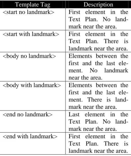
Each element in the Text Plan is analyzed and categorized according to the templates. Table 3 shows the list of template tag.
Template Tag Description
<start no landmark> First element in the Text Plan. No land-mark near the area. <start with landmark> First element in the
Text Plan. There is landmark near the area. <body no landmark> Elements between the first and the last ele-ment. No landmark near the area.
<body with landmark> Elements between the first and the last ele-ment. There is land-mark near the area. <end no landmark> Last element in the
Text Plan. No land-mark near the area. <end with landmark> First element in the
Text Plan. There is landmark near the area.
Table 3. List of Template Tag
Once all the elements are analyzed, it will pass the Text Plan and the assigned templates to the next sub-module. Using the Text Plan in the pre-vious module it will output the following:
<start no landmark><body no landmark> <body no landmark> <end no landmark>
Linguistic Realization
The template tags from the output of the dis-course planning are the basis on what template number will be retrieved from the database. The database used in this sub-module contains all the templates with their corresponding tag. For every template randomly chosen, the values from the Text Plan are used to complete the template. Us-ing the Text plan and the template tags it will output the following text:
Simula sa De La Salle University, dumiretso pagkatapos kumanan sa Da-gonoy.
Translation: ‘Starting from De La Salle University, you walk straight ahead and then turn right to Dagonoy’
Pagkatapos lumiko, dumiretso lamang at kumaliwa sa Leon Guinto.
Translation: ‘After you turn, you walk straight and then turn left to Leon Guinto.’
Ang susunod na gagawin ay hanapin ang Quirino at kumaliwa dito.
Translation: ‘The next step is to look for Quirino and turn left.’
Dumiretso lamang at matatagpuan ang Ospital ng Maynila.
Translation: ‘You walk straight ahead and you will see the Hospital on Manila.’
Once the text form is generated it will then pass it to the SMS Processing Module to send back the message containing the route to the sender.
4
Evaluation
The quality of the routes generated was evalu-ated based on standards discussed by Lovelace, et al. (1999). According to Lovelace, et al. (1999), the quality of a route direction can be measured by the information present in the text. Examples of this information are the landmarks, turns and descriptive route information. To con-firm the quality of the routed generated by our system two experiments were conducted.
Templates Text Plan
Discourse Planning
Linguistic Realization
[image:4.595.66.294.449.722.2]Experiment 1: Unfamiliar route and Map The goal of the experiment is to determine if a SMS response generated from the system is clear enough to direct a user to a safe place.
The task performed was to ask evaluators to answer a survey which contains an unfamiliar map and a route generated by the system. Fol-lowing the route found in the survey, the evalua-tors need to draw lines on the roads of the map starting from a specified starting location going to the destination.
The survey was answered by 30 respondents, 14 of which are male while the rest are female. Below is a summary of the evaluation:
Errors made by some respondents were through following the route per sentence. They go through the whole street that was mentioned in the first instruction be-fore they head to the next street indicated in the next instruction. This result to mis-takes in turning and the respondents had to go back since they missed a corner.
Errors were caused due to unfamiliarity of the area, based from their drawing there are some lines that went over the corners and passed through them. These errors were due to the problem with the generation of the route. Roads that are going to a curve are sometimes per-ceived as a turn in direction.
Based from the results of this survey, some roads are hard to simulate by only looking at the map and the given route. It is recommended that an actual simulation is needed to test the reliabil-ity of the generated instruction.
Experiment 2: Validate Generated Route The second experiment conducted is to evalu-ate the route generevalu-ated whether it is effective in giving out directions.
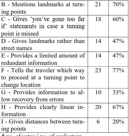
Same as the previous experiment we ask eval-uators to answer a survey. The survey was an-swered by 30 respondents, 14 of which are male while the rest are female. The survey contains an example route to be evaluated and a list of crite-ria made by Lovelace, et al. (1999). Evaluators were asked to check a criteria if it is present in the route generated by the system. Table 4 shows the result of the experiment.
Criteria Votes % *
A - Prepares the traveler for up-coming turning points to change location
21 70%
B - Mentions landmarks at turn-ing points
21 70%
C - Gives ’you’ve gone too far if’ statements in case a turning point is missed
18 60%
D - Gives landmarks rather than street names
14 47%
E - Provides a limited amount of redundant information
14 47%
F - Tells the traveler which way to proceed at a turning point to change location
23 77%
G - Provides information to al-low recovery from errors
10 33%
H - Provides clearly linear in-formation
20 67%
I - Gives distances between turn-ing points
6 20%
[image:5.595.304.531.70.309.2]* no. of votes / no. of evaluators
Table 4. Results of Experiment 2
The results show that the generated route was able to direct a user when there is a turning point to change direction. It is also observed that the route was able to use landmarks, but this is de-pendent on the data stored in the database. Crite-ria G and I are expected to be low because the templates used for the routes does not cover giv-ing directions to allow recovery of errors and does not give distances between turning points.
5
Conclusion
The BahaBa System was able receive a SMS re-quest, process the rere-quest, generate a route and its corresponding route message, and send the SMS back to the user.
Currently, the routes generated by the system are in the Filipino Language. But since we are using template-based NLG, it can easily be adapted to other languages by simply translating the templates that are stored in the database.
References
Dale, R., Geldof, S., & Prost, J.-P. (2003). CORAL: Using Natural Language Generation for Naviga-tional Assistance. 26th Australasian Computer Science Conference - Volume 16 (pp. 35-44). Australian Computer Society, Inc.
Department of Science and Technology. (2013). Pro-ject NOAH. Retrieved January 2013, from Google Play:
https://play.google.com/store/apps/details?id=ph.g ov.dost.noah.android
Fajardo, J., & Oppus, C. (2012). A mobile disaster management system using the android technology. WSEAS Transaction on Communications, 9(6), 343-353.
Lovelace, K. L., Hegarty, M., & Montello, D. R. (1999). Elements of good route directions in famil-iar and unfamilfamil-iar environments. Spatial infor-mation theory. Cognitive and computational foundations of geographic information science (pp. 65-82). Berlin: Springer.
Nueva Caceres Technology Solutions, Inc. (2013). iTyphoon. Retrieved January 2013, from Google Play:
https://play.google.com/store/apps/details?id=com. magnoconag.ITyphoon
The World Bank. (2012). 2012 Information and Communications and Development : Maximiz-ing Mobile. Washington DC: International Bank for Reconstruction and Development / The World Bank.
United Nations Economic and Social Commission for Asia and the Pacific and United Nations Office for Disaster Risk Reduction. (2012). Asia Pacific Disaster Report 2012. Bangkok, Thailand: Unit-ed Nations Economic and Social Commission for Asia and the Pacific and United Nations Interna-tional Strategy for Disaster Reduction.