TABLE OF CONTENTS: VOL. 50, NO. 4, July 1997 ARTICLES
Animal Ecology
338 Agricultural land use patterns of native ungulates in southeastern Montana by Jamie P. Selting and Lynn R. Irby
346 Impact of prescribed burning on vegetation and bii abundance at Matagorda Island, Texas by Jerrad T. Van? Hul, R. Scott Lutz, and Nancy E.
Mathews Animal Physiology
351 Grass hay as a supplement for grazing cattle I. Animal performance by Guillermo Villalobos, Don C. Adams, Terry J. Klopfenstein, James T. Nichols, and James B. Lamb
357 Grass hay as a supplement for grazing cattle II. Ruminal digesta kiuetics by Guillenno Villalobos, Terry J. Klopfenstein, Don C. Adams, Drew Shain, and Thomas E. Long
Plant Animal 361
367
371
374
381
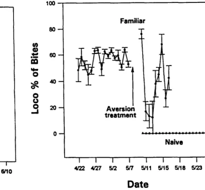
Creating aversions to locoweed in naive and familiar cattle by M.H. Ralphs, D. Graham, M.L. Galyean, and L.F. James
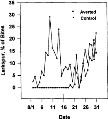
Persistence of aversions to larkspur in naive and native cattle by Michael H.
Ralphs
Damage from the larkspur mirid deters cattle grazing of larkspur by Michael H. Ralphs, Walker A. Jones, and James A. Pfister
Habitat selection patterns of feral horses in southcentral Wyoming by Kelly K. Crane, Michael A. Smith, and Doug Reynolds
Degradability of Andean range forages in llamas and sheep by Didier Genin and Muriel Tichit
Published bimonthly-lanuary, March, May, 3&j July, September, November
Copyright 1997 by the Society for Range Man- 391 agement
INDIVIDUAL SUBSCRIPTION is by member-
ship in the Society for Range Management. Plant-Ecology
LIBRARY or other INSTITUTIONAL SUB-
SCRIPTIONS on a calendar year basis are
$95.00 for the United States postpaid and
$112.00 for other countries, postpaid. Payment from outside the United States should be remit- ted in US dollars by international money order or draft on a New York bank.
BUSINESS CORRESPONDENCE, concerning
subscriptions, advertising, reprints, back issues, and related matters, should be addressed to the Managing Editor, 1839 York Street, Denver, Colorado 80206.
EDITORIAL CORRESPONDENCE, concerning
manuscripts or other editorial matters, should be addressed to the Editor, Gary Frasier, 7820 Stag Hollow Road, Loveland, Colorado 80538.
Page proofs should be returned to the Production Editor, 1839 York Street, Denver, Colorado 80206.
INSTRUCTIONS FOR AUTHORS appear on the inside back cover of most issues. T/-/E JOURNAL OF RANGE MANAGEMENT (ISSN 0022-409X) is published bimonthly for $56.00 per year by the Society for Range -Management, i 839 -York Street. Denver, Colorado 80206. SECOND ClAS$ POSTAGE paid at Denver, Colorado and additional offices.
Effects of sheep grazing on a spotted knapweed-infested Idaho fescue com- munity by Bret E. Olson, Roseann T. Wallander, and John R. Lacey
Early season grazing by cattle of tall larkspur-(Delphinium spp.) infested rangeland by James A. Pfister, Michael H. Ralphs, Gary D. Manners, Dale R.
Gardner, Kermit W. Price, and Lynn F. James
399 Structure and causes of vegetation change in state and transition model applications by Ricardo M. Rodriguez Iglesias and Mort M. Kothmann
409 Biomass and carbohydrates of spotted knapweed and Idaho fescue after repeated grazing by Bret E. Olson and Roseann T. Wallander
Plant Physiology
4W In vitro regeneration of fourwing saltbush [Atriplex canescens (Pursh) Nutt.]
by B. Mei, E.G. No, E.L. McWilliams, J.H. Gould, and R.J. Newton
419 Effect of seed moisture on Wyoming big sagebrush seed quality by Yuguang Bai, D. Terrance Booth, and Eric E. Roos
Economics/General Science
423 Ownership and management changes on California hardwood rangelands:
1985 to 1992 by Lynn Huntsinger, Lita Buttolph, and Peter Hopkinson Grazing Management
431 Viewpoint: Are grazing rights on public lands a form of private property? by Leigh Raymond
Technical Note
439 Vegetation response to increasing stocking rate under rotational stocking by C.A. Taylor, Jr., M.H. Ralphs, and M.M. Kothmann
BOOK REVIEWS
444 The Lochsa Story-Land Ethics in the Bitterroot Mountains by Bud Moore, Barns of the West. A Vanishing Legacy by Arthur A. Hart.
POSTMASTER: Return entire journal with
address change -RETURN POSTAGE GUAR-
ANTEED to Society for Range Management,
446 Erratum 1839 York Street, Denver, Colorado 80206.
PRINTED IN USA
Managing Editor
CHARLES B. (BUD) RUMBURG 1839 York Street
Denver, Colorado 80206 (303) 3557070
Fax: (303) 355-5059 e-mail address:
[email protected] Editor
GARY FRASIER Copy Editor JO FRASIER
7820 Stag Hollow Road Loveland, Colorado 80538 Production Editor PAllY RICH
Society for Range Management 1839 York Street
Denver, Colorado 80206 Book Review Editor
DAVID L. SCARNECCHIA Department of Natural Resource Sciences Washington State University Pullman, Washington 99164-6410 e-mail address:
Associate Editors VIVIEN G. ALLEN
Texas Tech University Dept. of Plant & Soil Science Box 42122
Lubbock, Texas 79409-2122 DAVID BELESKY
1224 Airport Road P.O. Box 400
Beaver, West Virginia 25813 TERRANCE G. BIDWELL
Department of Agronomy Oklahoma State University Agric. Hall, Room 373 Stillwater, Oklahoma 74078 STUART P. HARDEGREE
USDA/ARS
800 Park Blvd., Plaze IV, #105 Boise, Idaho 83712.
MARK JOHNSON
Louisiana State University Forestry and Wlldlife Management Baton Rouge, Louisiana 70803
RICHARD E. JOOST American Plant Food Corp.
609 Dustin Drive Columbia, Missouri 65203 STEVEN 0. LINK
Washington State Univ.-Tri Cities Biological Sci.
100 Sprout Rd.
Richland, Washington 99352 DAVID MICHALK
Agric. Res. & Veterinary Centre Forest Road
Orange, NSW 2800 AUSTRALIA
M. KEITH OWENS Texas A&M University Research Center 1619 Garner Field Road Uvalde, Texas 78801 JEFF POWELL
Dept. of Range Management University of Wyoming University Station, Box 3354 Laramie, Wyoming 82071
MIKE RALPHS 1150 East 1400 North Logan, Utah 84321 SHERM SWANSON
Renewable Resources Center University of Nevada 1000 Valley Road Rena, Nevada 89512 JOHN TANAKA
Agr. & Res. Econ.
Oregon State University 213 Ballard Ext. Hall Corvallis, Oregon 97331 JOHN WALKER
US Sheep Exp. Station HC 62, Box 2010 Dubois, Idaho 84323 WALTER WILLMS
Agric. Canada Res. Center Lethbridge, AB Tl J 481 CANADA
President
JOHN C. BUCKHOUSE Oregon State University
Department of Rangeland Resources Corvallis, Oregon 97331 1st Vice-President
E. LAMAR SMITH, JR.
Rangeland Resources Management, BSE 325 University of Arizona
Tucson, Arizona 85721 2nd Vice-President KENDALL L. JOHNSON
Department of Range Resources University of Idaho
Moscow, Idaho 83843 Executive Vice-President CHARLES B. RUMBURG
Society for Range Management 1839 York Street
Denver, Colorado 80206 (303) 3.55-7070
THE SOCIETY FOR RANGE MANAGEMENT, founded in 1948 as
he American Society of Range Management, is a nonprofit association incorporated under the laws ,f the State of Wyoming. It is recognized exempt from Federal income tax, as a scientific and educa- ional organization, under the provisions of Section 501(c)(3) of the Internal Revenue Code, and also ,s classed as a public foundation as described in Section 509(a)(2) of the Code. The name of the Society was changed in 1971 by amendment of the Articles of Incorporation.
The objectives for which the corporation is established are:
-to properly take care of the basic rangeland resources of soil, plants, and water;
-to develop an understanding of range ecosystems and of the principles applicable to the management of range resources;
-to assist all who work with range resources to keep abreast of newfindings and techniques in the science and art of range management;
-to improve the effectiveness of range management to obtain from range resources the products and values necessary for man’s welfare;
-to create a public appreciation of the economic and social benefits to be obtained from the range environment;
-to promote professional development of its members.
Membership in the Society for Range Management is open to anyone engaged in or interested in any aspect of the study, management, or use of rangelands. Please contact the Executive Vice- President for details.
Diitors 1995-1997
E.T. “TOM” BARTLETT Colorado State University
Department Rangeland Ecosystem Science Fort Collins, Colorado 80523
MARGUERlTE B. “MEG” SMITH Box 7
Glen, Montana 59732 l!w6-1998
RODNEY K. HEITSCHMIDT Ft. Keogh LARRL Rt 1, Box 2021
Miles City, Montana 59301
The Journal of Range Management is a publication of the Society for Range Management. It serves as a forum for the presentation and discussion of facts, ideas, and philosophies pertaining to the study, management, and use of rangelands and their several resources. Accordingly, all material published herein is signed and reflects the individual views of the authors and is not necessari- ly an official position of the Society. Manuscripts from anyone-nonmembers as well as members-are welcome and will be given every consideration by the editors. Editorial comments by an individual are also welcome and, subject to acceptance by the editor, will be published as a “Viewpoint.”
RONALD E. SOSEBEE 6902 Geneva Lubbock, Texas 79413
In Cooperation With: Some of the articles appearing in The Journal of Range Management (JRM) are presented in cooperation with The American Forage and Grassland Council (AFGC). This coopera- tion consists of JRM acceptance of professional papers in forage grazing management and related sub- ject areas from AFGC members and the appointment of two AFGC affiliated associate editors
to JWs Editorial Staff. Tbe American Forage and Grassland Council Offices: 210 W. 8th Street, #A, PO. Box 94, Georgetown, Texas 78626; C. Pat Bagley, President; Dana Tucker, Executive Secretary.
1997-1999 BOB BUDD
Red Canyon Ranch 350 Red Canyon Rd.
Lander, Wyoming 82520 ANGELA S. WILLIAMS
Route I, Box 108 Paoli, Oklahoma 73074
Contribution POliCy: The Society for Range Management may accept donations of real and/or personal property subject to limitations set forth by State and Federal law. All donations shall be subject to management by the Executive Vice President as directed by the Board of Directors and their discretion in establishing and maintaining trusts, memorials, scholarships, or other types of funds.
The term of office of all elected officers and Individual endowments for designated purposes can be established according to Society policies. Gifts, directors begins in February of each year during bequests, legacies, devises, or donations not intended for establishing designated endowments will be the Society’s annual meeting. deposited into the SRM Endowment Fund. Donations or requests for further information on Society poli- cies can be directed to the Society for Range Management, Executive Vice-President, 1839 York Street, Denver, Colo. 80206. We recommend that donors consult Tax Advisors in regard to any tax considera- tion that may result from any donation.
J. Range Manage.
50:338-345
Agricultural land use patterns of native ungulates in south- eastern Montana
JAMIE P. SELTING AND LYNN R. IRBY
Authors are soil conservationist, Natural Resource Conservation Service, Havre. Mont. 59501; and professor of Wildlife Management, Biology Department, Montana State University, Bozeman, Mont. 59717. At the time of the research, the senior author was a graduate research assistant in the Biology Department, Montana State University, Bozeman, Mont. 59717.
Abstract Restimen
Mule deer (Odocoileus hemionus), white-tailed deer (Odocoileus virginianus), and pronghorn antelope (Antilocapra americana) use of 6 agricultural land use categories in southeast- ern Montana were monitored to identify use patterns at specific sites. Alfalfa (Medicago sativa L.), bottom rangeland, Conservation Reserve Program (CRP) lands, upland rangeland, wheat (Triticum aestivum L.) stubble, and growing wheat were observed during dawn, day, dusk, and night hours over a period of 12 months. Mule deer densities on alfalfa peaked in fall and again in spring. The CRP lands were selected in all seasons.
Rangeland sites were most heavily used in winter and summer.
White-tailed deer used CRP lands in ail seasons except fall.
Alfalfa was selected in fail, spring, and summer. Antelope densi- ties on alfalfa were highest in spring and fall, while growing wheat fields were used most in spring. Antelope in the northern study area selected CRP land in all seasons except fall. Densities of animals and patterns of use observed during thii study would be unlikely to produce significant impacts on forage or crops at most of our study sites.
Key Words: mule deer, white-tailed deer, pronghom antelope, habitat use, agriculture
Increasing wildlife populations and demands for greater efti- ciency in agricultural production have produced conflicts between agricultural and wildlife advocates in the Great Plains (Severson 1981). Both groups perceive damage from wildlife as a problem, but they disagree on its extent and importance (Conover and Decker 1991, Adkins 1991, Lacey et al. 1993, Conover 1994, Wywialowski 1994, Irby et al. 1996). Attempts to measure dam- age from wild ungulates have been unsatisfactory because of variability in methodology, sampling intensity, and distribution of ungulates at local and regional scales (Tebaldi 1982, Adkins
1991, Matschke et al. 1984).
This study was initiated to provide quantitative information on wild ungulate use of agricultural lands in southeastern Montana.
to thank E. Williams, Dr. B. Thompson, Dr. D. Gustafson, Dr. J. Lacey, Dr. C. Wambolt, Research was funded by the USDA through Sustainable Agriculture Research and Fklucation Grant LW-91-24 directed by Drs. J. Riesselman and J. Johnson. Authors wish
and members of the Carter-Fallon Forage Committee for assistance during the project
Los usos por parte de1 venado burro (Odocoileus hemionus), el venado cola blanca (Odocoileus virginianus) y el antilope prong- horn (Antilocapra americana) de seis categorias de tierras de uso agricola en el sureste de1 estado de Montana se examinaron para identificar las tendencias de uso en sitios especificos.
Observamos la alfalfa, 10s terrenos de pasta bajos, las tierras de1 Programa de Reserva para la Conservaci6n (el CRP), 10s ter- renos de pasto altos, el rastrojo de trigo, y el trigo creciente durante el alba, el dia, el crep6sculo y la noche a trav4s de un period0 de dote meses. Las densidades del venado burro en la alfalfa alcanzaron el milximo en el otofio y otra vez en la prhnav- era. Rstos venados seleccionaron las tierras del CRP en todas las estaciones. Utilizaron 10s sitios de 10s terrenos de pasto m8s durante el inviemo y el verano. Los venados cola blanca usaron las tierras de1 CRP en todas las estaciones menos el otoiio.
Seleccionaron la alfalfa en el otoiio, la primavera y el verano.
Las densidades de1 antilope en la alfalfa alcanzaron el mhximo en la primavera y en el otoiio, mientras se utilizaron 10s sembra- dos de trig0 creciente mris durante la primavera. Los antilopes en el drea norteiia de1 estudio seleccionaron las tierras de1 CRP en todas las estaciones menos el otoiio. Es improbable que las densidades de 10s animales y las tendencias de uso observadas durante este estudio produzcan impactos substanciales en 10s pastas o en las cosechas de la mayor parte de nuestros sitios estu- diados.
Ranchers in Carter and Fallon Counties identified consumption of locally grown hay and forage from native range by wild ungu- lates as a possible economic threat. Studies sponsored by the
dance of wild ungulates at specific sites.
Montana Department of Fish, Wildlife, and Parks (MDFWP) in the area (Egan 1957, Campbell 1970, Freeman 1971, Griffiths 1990, Olenicki 1993) did not support this contention, but they focused on the ecology of deer and antelope with agricultural impacts addressed as a secondary objective. This study was designed to focus on animal use patterns in agricultural cover types. The primary objectives were to 1) identify seasonal prefer- ences of wild ungulates for agricultural cover types, and 2) to determine if topographic, physical, and biological characteristics associated with specific sites could be used to predict the abun-
and landowners in Carter County who allowed us access to their property.
Manuscript accepted 21 Sep. 1996.
338 JOURNAL OF RANGE MANAGEMENT 50(4), July 1997
Materials and Methods Ungulate Count Procedure
From September 1992 to August 1993, deer and antelope counts were conducted on 56 sites located within 6 major land use categories. These were alfalfa, bottom rangeland, Conservation Reserve Program lands (CRP), upland rangeland, wheat stubble, and growing wheat (Table 1). Seven to 10 obser- vation sites were chosen in each land use category. Travel routes were designed so the direction of travel could be alternated.
Study Area
The study was conducted on sites selected along 2 routes in Carter County, Montana. Observation sites where animals were counted ranged in size from 10 to 100 ha. Sites were placed along unpaved county roads that were maintained as school bus routes to insure year-round accessibility. The northern route (Ekalaka route) included 42 observation sites that encompassed an area of 1,213 ha. Roads on this route encircled the Ekalaka Hills division of Custer National Forest but were located in open, rolling prairie at distances of 0.5 to 6.4 km from forested areas. Vegetation in prairie areas consisted of sagebrush-grassland communities inter- spersed with agricultural lands. Dominant species were big sage- brush (Artemesia tridentata Nutt.), crested wheatgrass (Agropyron desertorum (Fisch.) Schultes), western wheatgrass (Agropyrum smithii (Rydb.) Gould), prairie junegrass (Koeleriu macruntha (Ledeb.)Shultes), blue grama (Bouteloua grucilis (H.B.K.) Lag. ex Stud.), and needle-and-thread (Stipu comu?u Trin. and Rupr.). The CRP lands contained crested wheatgrass and alfalfa (Medicago s&vu L.). Important tree and shrub species along streams and coulees were green ash (Fruxinus pennsylvuni- cu Marsh.), common snowberry (Symphoricurpos ulbus (L.) Blake), fragrant sumac (Rhus aromatica Ait.), and common chokecherry (Prunus virginiana L.).
The southern route (Box Elder route) included 14 observation sites totaling 462 ha located along a 21-km reach of Box Elder Creek. This route was characterized by rolling plains dissected by ephemeral creeks. Box Elder Creek frequently is dry during sum- mer but had surface water throughout our study. Dominant species in the area were similar to those on the Ekalaka route except for stands of box elder (Acer negundo L.), plains cotton- wood (Populus deltoides Bartr. ex Marsh.), and silver buffalober- ry (Shepherdiu argenteu (Pursh) Nutt.) along portions of Box Elder Creek and greasewood (Surcobutus vermiculutus (Hook.) Torrey) communities in some bottom land sites.
Average annual precipitation in the Ekalaka area (39.2 cm) is slightly greater than in the Box Elder area (32.9 cm) (NOAA 1993). Seventy-five percent of precipitation in both areas occurs as rain during April-September (Carter County Conservation District 1976). Precipitation for September 1992 to August 1993 was above average for both study areas with significantly higher rainfall occurring in June and July (NOAA 1993). Long term average temperature is 20°C for July and 7°C for January.
At the time of the study, Carter County was approximately 90%
rangeland, 1.7% crops, 1.9% CRP, 4.2% forest, and 2.2% other.
Major agricultural crops, in order of abundance, were winter wheat (Triticum uestivum L.) (including fallow), alfalfa, barley (Hordeum vulgare L.), oats (Avena sutivu L.), rye (Secule cereale L.), and safflower (Curtthamnus tinctorius L.). Sixty-five percent of the land is deeded, 7% is state land, and the remainder is feder- ally owned. (U.S.D.A., Agricultural Stabilization and Conserva- tion Service, unpubl. data).
Deer and antelope harvest reports (Montana Dep. Fish, Wildlife and Parks, unpubl. data) for 1992 suggested that mule deer popu- lations were at or slightly above the 30-year average. White- tailed deer harvest levels were approximately average, and ante- lope harvest was slightly above average.
At each observation site, presence of livestock, number and species of deer, and number of antelope were recorded (1 deer or 1 antelope = 1 observation). Activity and age were recorded when possible.
Table 1. Land use categories used in wild ungulate surveys. Numbers of sites (n) and number of hectares @a) for each type are given ia the table-.
Land Use Tvoe Characteristics Alfalfa
(n = 10, ha = 235) Bottom Rangeland (n = 10. ha = 348)
Conservation Reserve Program (CPR) (n= lO,ha=351)
Upland Rangeland
(n = 10, ha = 319)
Wheat stubble (n=9,ha=231)
Growing wheat (n=7,ha= 183)
Fields with a grass-alfalfa mix containing at least 20% alfalfa canopy coverage prior to first harvest.
Harvested for livestock feed (not seed production).
Native or reseeded rangeland used for livestock grazing in any season. Located in the lowest ele- vation in relation to surrounding topography.
Usually adjacent to perennial or intermittent creeks.
Lands enrolled in the Conservation Reserve Program.
Seedings older then three years containing an aver- agemix of alfalfa (0.45 kg pls (pure live seeds)) and crested wheatgrass (1.8 kg ~1s). Pubescent
(Agropyron trichophomm (Link) Richt.) and inter- mediate (A. intermedium (Host) Beauv. wheatgrass were often substituted and yellow sweet clover (Melilofus 0@5mlis (L.)) was included occasionally.
Native or reseeded rangeland used principally for livestock grazing in any season. Low relief sites located in high elevations in relation to surrounding topography. Usually elevated 2 or more terrace levels above bottom rangeland sites.
Winter wheat that was seeded in the fall of 1991 and harvested in the early fall of 1992. Plants were mature when the study was initiated.
Winterwheatthatwasseededinthefallof 1992tobe harvested in the early fall of 1993. Winter wheat that was planted and matured during the study period.
Counts were conducted on each observation site at 4 time peri- ods: 1) dawn (l/2 hour before to l/2 hour after sunrise); 2) day (2 hours after sunrise to 2 hours before sunset); 3) dusk (15 minutes before sundown to 45 minutes after sundown); and 4) night (1 hour after sundown until the observation route was complete).
Observations were not conducted when fog, snow, or rain impaired visibility. Binoculars were employed to verify species sighted at dawn, day, and dusk. Night observations were aided by a 1.5~million candle power spotlight and binoculars.
To assess observation efficiency, 1 person walked through a set of observation sites after making counts from the road while another observer watched for animals that flushed. The CRP lands were tested in winter and summer. Alfalfa, bottom range- land, and upland rangeland were tested only in summer.
Seasons were defined as fall (September-November), winter (December-February), spring (March-May), and summer (June-August). Counts were conducted 10 times per season at
JOURNAL OF RANGE MANAGEMENT 50(4), July 1997 339
each time period giving 40 counts at each observation site per season.
To compensate for unequal observation site sizes, an average ungulate density was determined for each land use category in each month. Monthly data were combined to form seasonal esti- mates.
gories had less hiding cover available to animals and were checked only during the day (n=28 tests). More than 90% of the animals present in these types were visible from the road. For all 3 species, the number of observations in land use categories was not proportional to availability of categories in any season (chi- square range = 19.1 l-3652.83, P < O.OS)(Table 2).
The total number of deer and antelope observed in each land use category in each season was compared to availability of land use categories on survey routes (Neu et al. 1974). Results are reported as use less than (-), greater than (+), or equal to (=) availability among all land use categories examined at P c 0.05.
Use Patterns of Agricultural Cover Categories
Wild Ungulate Associations with Landscape Variables For all observation sites, distance to the nearest agricultural crop (alfalfa, CRP, and wheat) was measured from topographic maps. Slope and the distance from each observation site to the nearest perennial creek, intermittent creek, hiding cover, forest, and occupied homestead were also measured. Data from both study routes were combined to test for associations between land- scape variables and deer and antelope abundance. Seasonal corre- lations and comparisons were determined by Spearman rank cor- relations (Rs) and Kruskal-Wallis tests (Conover 1980). We determined if combinations of landscape level variables were useful in predicting ungulates numbers at specific sites using multiple linear regression (Neter et al. 1993). Individual models were developed for each species in each season. Ungulate density (total number of ungulates observed on a site in 40 replicated counts/area of the site) was the dependent variable in all models.
The independent variables used in the regression models were distances to landscape features and percent slope.
Mule deer. Mule deer densities per land use category in indi- vidual months varied from 0.0 to 0.42/ha (Fig. 1). In fall, CRP and alfalfa were selected (use>availability) in sites along both observation routes, and all other types were avoided (usecavail- ability) (Table 2). During winter, CRP was selected on the Ekalaka route and upland range on the Box Elder route. Most other categories were used less than expected. In spring and sum-
EKALAKA MULE DEER 0.16~
m
0.14- 0 WGR
a 0.12- 5 2 O.l-
%
= s 0.06- c z 0.06.
B n 0.04-
0.02 1
Wild Ungulate Associations with Vegetation and Livestock Vegetative composition was estimated for alfalfa, rangeland, and CRP at each observation site in late June and early July.
Vegetative cover was estimated by recording the percent of the ground covered by grasses, forbs, shrubs, and mosses within 20 by 50 cm plots at 20 random points at each observation site. The vegetative cover classes were: cl%, l-5%, >5-25%, >25-50%,
>50-75%, >75-95%, and >95%. The mid points of the coverage classes were used to calculate means and Spearman rank (Rs) correlations were used to test for associations between wild ungu- lates and vegetative characteristics for alfalfa, CRP, upland rangeland and bottom rangeland. Spearman rank correlations were also used to test the strength of association between wild ungulates and livestock numbers at observation sites.
ot
MONTH
BOXELDER MULE DEER 0.7-f
0.6-
Results
During the study period, 4,687 mule deer, 1,322 white-tailed deer, and 2,767 antelope observations were recorded. Forty-two percent of mule deer, 93% of white-tailed deer, and 66% of ante- lope observations were made on the Ekalaka route. The dominant observed activity in all seasons was feeding, followed by bedding and traveling.
3 OS- i3 2 s O.4- z s.
c 0.3 P 8 0.2-
O.l-
0-r
M J J AUG MONTH
We did not find major differences in sightability among land use categories. In CRP lands, we observed an average of 85%
(n=lO tests) of all animals present at night and 80% (n=13 tests) of all animals present during the day. All other land use cate-
Fig. 1. Average mule deer densities on alfalfa (ALF), bottom range- land and (BOT), Conservation Reserve Program (CRP), upland rangeland (UPL), wheat stubble (WST), and growing wheat (WGR) observation sites in the Ekalaka and Box Elder study areas from September 1992 to August 1993.
340 JOURNAL OF RANGE MANAGEMENT 50(4), July 1997
Table 2. Mule deer, white-tailed deer, and antelope use of agricultural land use categories in the Ekahka and Box Elder study areas.
Area USe Fall wiiler
MULa WTD ANT MUL WTD ANT
Spring Summer
MUL WTD ANT MUL WTD ANT
Ekalaka AL@ += + + - - = + + + =
BOT - - - _ - _ - - = - =
CRF + = = + + + + + + + + +
UpL - - - - _ = - = -
WST _ = _ - - - - - -
WGR - = = - - - + - -
BoxElder ALF + + * - * = = + =
BOT - = = - * + - * = - - =
CRF + - = * - + * = + + -
UPL - - - + * - * = - =
WST - - + * - * - - -
WGR - = = _ * - * = = -
‘MUL = mule de-cc WTD = white-tailed deer; ANT = antdope.
‘m = alfalfa; BOT = both” IWlgehd; CM = conservation mse~,‘e pr~@tt,; UPL = upland ran@,,&; wsr =w,,at St&&; won
= growing wheat.
‘(+) = use greater than availability; (=) = use proportional to availability; (-) = use less than availability; (*) = no test.
mer, CRP was selected along both routes, and most other cate- gories were avoided.
White-tailed deer. White-tailed deer densities ranged from 0.0 to 0.1 l/ha (Fig. 2). In fall, white-tails selected alfalfa and avoided upland range sites. Use of other types was either propor- tionate to availability or less than availability, but relationships differed between routes (Table 2). In winter, they selected CRP and avoided all other land use categories. In spring and summer they selected alfalfa fields and CRP and used all other land use categories proportionally less than their availability. During win- ter and spring, very few white-tailed deer were seen on the Box Elder route so selectivity was based only on sites along the Ekalaka route.
Antelope. Monthly antelope density in land use categories var- ied from 0.0 to O.Wha (Fig. 3). Use patterns along the 2 study routes varied more for antelope than for deer (Table 2). In fall, antelope observed on the Ekalaka route selected alfalfa and avoided wheat stubble. On the Box Elder route, they avoided alfalfa and selected stubble. In winter, antelope observed on the Ekalaka route selected CRP and avoided bottom rangeland. The only antelope seen on the Box Elder route in winter were in bot- tom rangeland. In spring, antelope on the Ekalaka route selected alfalfa, CRP, and growing wheat and avoided other categories.
All categories except wheat stubble were used in proportion to availability along the Box Elder route. In summer most categories were used in a similar manner on both routes except CRP. This category was selected in the Ekalaka area and avoided in the Box Elder area.
Wild Ungulate Associations with Landscape Variables Mule Deer. Mean numbers of mule deer on the 56 observation sites in each season were negatively correlated with distances to landscape variables in 24 of 36 Spearman Rank Correlations we cal- culated (Table 3), but only 3 correlations were significant (PC 0.05).
In winter and spring, deer numbers were negatively associated with distance to CRP. In summer, deer numbers were positively correlat-
ed with distance to forest cover.
JOURNAL OF RANGE MANAGEMENT 50(4), July 1997
White-tailed Deer. White-tailed deer observations were nega- tively correlated with landscape variables in 20 of 36 tests (Table 3). Four correlations were significant. In fall and spring, more white-tailed deer were seen in sites with little or no slope than in steeper terrain. In spring, white-tailed deer numbers were nega- tively correlated with distance to CRP and forest cover.
Antelope. Negative associations between antelope numbers and landscape variables were calculated for only 8 of 36 tests.
There were significant positive associations between antelope numbers and 2 variables, distance to forest cover and occupied homesteads, in spring and summer.
Multiple Regression Models
Twelve multiple regression models, 3 species in 4 seasons, were tested. Only 2 of the 12 models detected marginally signifi- cant relationships (P c 0.10) between wild ungulates and land- scape variables. None of the models explained a substantial amount of the variability (R2 < 0.51) in ungulate observations (Table 4).
Wild Ungulate Associations with Vegetation Coverage and Livestock
The average canopy coverage in bottom rangeland sites was 55% grass, 33% forb, and 8% shrub. Canopy coverage for upland sites averaged 49% grass, 28% forb, and 11% shrub. Alfalfa canopy cover prior to the first cutting was 29%. Canopy coverage of the introduced wheatgrasses used in seeding CRP averaged 43% and alfalfa averaged 6% (for all CRP fields). Other grasses, other forbs, and shrubs combined had a mean canopy coverage of 7%. Of 12 Spearman correlations calculated (3 ungulates species in 4 seasons) for sites with perennial vegetative cover, only 1 was significant (P < 0.05). Antelope numbers were negatively associ- ated (R, = -0.803, P < 0.01) with alfalfa canopy coverage in sum- mer.
Livestock distribution varied seasonally in the study area.
Cattle were grazed on upland and lowland range sites through the year. In winter, there was a tendency for higher use of bottom rangeland to facilitate feeding operations. In summer, cattle tend-
341
EKAIAKA WHITE-TAILED DEER 0.16-l
R
m WGR 0.14-
MONTH
BOXELDER WHITE-TAILED DEER 0.06
MONTH
Fii. 2. Average white-tailed deer densities on alfalfa (ALF), bottom rangehnd POT), Conservation Reserve Program (CRP), upland rangeland (UPL), wheat stubble (WST), and growing wheat (WGR) observation sites in the Ekalaka and Box Elder study areas from September 1992 to August 1993.
ed to be seen in bottom land pastures more than in upland pas- tures probably in response to shade, water, and/or forage in ripar- ian areas. In winter and early spring, many ranchers allowed their cattle to graze on alfalfa and wheat fields. There were no signifi- cant differences (Kruskall-Wallace tests, P = 0.12 to 0.40) in number of domestic sheep observed in upland and lowland sites in any season. Most ranchers did not graze sheep on alfalfa or wheat fields. Horses were observed on only one observation site and were not included in the analysis.
Correlations between ungulate numbers and cattle were gener- ally poor. White-tailed deer numbers were negatively correlated with cattle presence in spring (R, = -0.386, P < O.Ol), and sum- mer (R, = -0.369, P c 0.01). There were no significant (P < 0.05)
associations evident between sheep and wild ungulates.
Use of Agricultural Lands
Upland and bottom land range were the most abundant of the agricultural cover categories we sampled and the most common agricultural land use types in eastern Montana (Montana Agricultural Statistics Service 1993). Wild ungulates generally used these types in less than expected proportions. This low rela- tive level of use does not imply that native range is unimportant to wild ungulates in Montana (Pyrah 1987, Wood et al. 1989). It merely indicates that rangeland was so abundant that it was not limiting at current population levels. During 1992-93, forage Table 3. Seasonal Spearman rank (Rs) correlation coefficients for wild
ungulates and landscape variables in all seasons.
MUL’ W-l-D ANT
Rsb P Rs P RS P
Dist to’ ALF -0.12
CRP -0.17
WHT 0.09
PCK -0.16
ICK -0.22
cov -0.18
FOR -0.08
Hh4SD -0.27 SL5PE -0.02
Dist to ALF -0.07
CRF -0.30
WHT 0.15
PCK -0.19
ICK 0.16
cov -0.20
FOR 0.26
IihGD 0.05 SLOPE 0.12
Dist to’ ALF -0.18 CRF -0.3 1
WHT 0.02
PCK -0.20
ICK 0.07
cov -0.12
FOR 0.14
Hh4SD -0.24 SLOPE -0.04
Dist to ALF -0.10
CRP -0.14
WHT -0.07
PCK -0.23
ICK 0.04
cov -0.07
FOR 0.30
HMSD -0.26
Fall
0.45 0.10
0.27 -0.19
0.57 0.02
0.23 0.10
0.10 -0.08
0.19 0.04
0.58 -0.20 0.05 -0.03 0.88 -0.35
winter
0.67 0.13
0.04 0.09
0.36 0.06
0.17 0.01
0.24 0.18
0.14 -0.06
0.05 0.11
0.72 0.18
0.38 -0.13 Spring
0.25 0.12
0.03 -0.40 0.90 -0.05
0.14 0.21
0.59 -0.19 0.38 -0.13 0.31 -0.33
0.08 0.12
0.78 -0.28 Summer
0.53 0.06
0.37 -0.17 0.69 -0.04
0.10 0.14
0.75 -0.26 0.64 -0.04 0.03 -0.06 0.06 -0.11
0.51 -0.01 0.94
0.21 0.04 0.82
0.90 0.12 0.46
0.45 -0.20 0.15
0.54 0.18 0.19
0.78 0.05 0.72
0.15 0.14 0.31
0.82 -0.01 0.97
0.01 0.01 0.93
0.40 0.28 0.07
0.54 0.01 0.94
0.74 0.18 0.26
0.96 0.06 0.68
0.18 0.27 0.05
0.67 0.08 0.58
0.44 0.26 0.06
0.19 0.09 0.50
0.34 0.16 0.26
0.43 0.00 0.98
0.01 -0.02 0.91
0.77 0.03 0.85
0.11 0.08 0.57
0.16 0.11 0.41
0.33 0.11 0.43
0.01 0.03 0.02
0.40 0.30 0.03
0.04 -0.12 0.40
0.68 0.10 0.51
0.27 -0.02 0.91
0.80 -0.07 0.69
0.30 0.05 0.70
0.06 0.18 0.18
0.76 0.22 0.11
0.65 0.27 0.04
0.43 0.34 0.01
SLOPE 0.15 0.28 -0.17 0.21 -0.12 0.39
g: =muIe deq WTD = white-tailed&r; ANT = antelope.
spearman rank correlation cocfticicnt; P = p-value.
kist = distanm from observation site to nearest: ALF = alfalfa; CRP = conservation reserve program land; WHT = wheat; PCK = perennial cm& ICK = intemdttent creel: COV = hiding cme& FOR = fonst; HMSD - occupied homestead. SLOPE = land slope (%).
342 JOURNAL OF RANGE MANAGEMENT 50(4), July 1997