! "
#"# $ % %#
& ''' (
© 2010, IJARCS All Rights Reserved 29
A Computational Model of Spatial Learning by a Person with Visual Disability: An
Exploratory Study
Kanubhai K. Patel* Asst. Professor
School of ICT Ahmedabad University
Ahmedabad, India [email protected]
SanjayKumar Vij Director (CE-IT-MCA)
SVIT, Vasad, India [email protected]
Abstract:A computational model, named as Non-visual Spatial Learning (NSL) model, of spatial learning by a person with visual disability through virtual environment (VE) is proposed in this paper. We report an experiment that investigates the validity of our NSL model by prototype system implementation based on the model. Fourteen participants ranging from 17 to 35 years old participated in experiment. They were divided in to two groups — bind-folded sighted (8 participants), and blind (6 participants). They learned spatial layout in VE using two exploration modes: guided (training phase) and unguided (testing phase). In unguided exploration mode, spatial layout knowledge was assessed by asking participants to perform object localization task and target-object task. The results reveal that there were significant improvements in post-training navigation performance of the participants.
Keywords: assistive technology; cognitive maps; spatial learning; virtual environment; visually impaired
I. INTRODUCTION
Unlike in case of sighted people, spatial information is not fully available to visually impaired people (VIP) causing difficulties in their mobility in new and unfamiliar locations. As they are handicapped to gather this crucial information, they face great difficulties in generating efficient mental maps of spaces and, therefore, in navigating efficiently in new and unfamiliar spaces. Consequently, many VIP become passive, depending on others for assistance. More than 30% of the VIP do not ambulate independently outdoors ([2]; [5]). This constraint can be overcome by providing mental mapping of spaces, and of the possible paths for navigating through these spaces which are essential for the development of efficient orientation and mobility skills. Such assistance might not be required after a reasonable number of repeated visits to the new space as these visits enable formation of mental map of the new space subconsciously. Thus, a good number of researchers focused on using technology to simulate visits to a new space for cognitive maps formation. Although isolated solutions have been attempted, no integrated solution of spatial learning to VIP is available to the best of our knowledge. Also most of the simulated environments are far away from reality and the challenge in this approach is to create a near real-life experience.
A computational model of spatial learning through VE is presented in this paper. The model is based on Landmark-Route-Survey (LRS) theory [10], the most accepted theory of spatial learning. An attempt has been made to combine the findings and methods from several disciplines including cognitive psychology, behavioral science and computer science (specifically VE technology). This paper addresses the potential of VE as a tool for studying spatial learning by VIP and thereby enhancing their capabilities to interact in a spatial environment in real life. It would be useful to understand as to how they learn and acquire basic spatial knowledge in terms of landmarks and configuration of spatial layout and also how navigation tasks are improvised. Understanding the use of such
knowledge to externalize and measure virtually perceived cognitive maps is also important.
The purpose of the current study is to evaluate the benefits of the assistive system based on our NSL model for spatial learning which leads to enhancement of the mobility skills of VIP.
The remaining paper is structured as follows: Section-2 presents the research background; Section-3 presents a computational model of spatial learning; Section-4 describes quality factors for spatial learning techniques; Section-5 describes planning and procedure for experiments; Section-6 illustrates the results; while Section-7 concludes the paper.
II. SPATIAL LEARNING RESEARCH BACKGROUND
In recent years, a plethora of assistive navigation technologies have been designed to enhance and maintain the independence of the community of visually impaired. Research on the use of haptic devices by people who are blind for construction of cognitive maps includes ([5]; [9]).
The use of audio interface by VIP for construction of cognitive maps includes Audio-Tactile BATS [6]; modeling Audio-Based Virtual Environments for Children with Visual Disabilities [8]. The use of audio-haptics interface by VIP for construction of cognitive maps includes haptics and vocal navigation software (Virtual Sea – for Blind sailors) [11]; Haptics Soundscapes team [7].
Some of the many general factors underlying the idea that VE technology is likely to be useful for training spatial behavior in the real world are summarized [3]. An understanding of formation of cognitive maps by VIP through VE is required for designing VE based assistive system to enhance mobility skills of them.
III. A COMPUTATIONAL MODEL OF NON-VISUAL SPATIAL
LEARNING (NSL)
© 2010, IJARCS All Rights Reserved 30 available to the best of our knowledge. Yet no researcher has
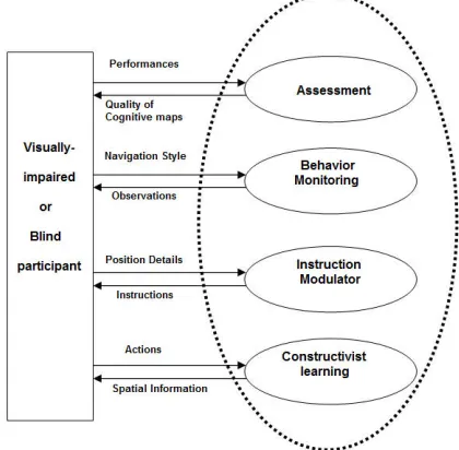
[image:2.612.75.285.160.366.2]given a computation model to cover all the aspects of the spatial learning process of VIP. The NSL model provides abstraction of non-visual spatial learning by VIP. Special emphasis is placed on internalizing and externalizing cognitive maps and online assessment of perceived cognitive maps by users. Understanding how spatial learning tasks are constructed is useful in determining how best to improve performance. We should decompose the various tasks of spatial learning in a generic way.
Figure 1. Components of Non-visual Spatial Learning (NSL) Model
To describe the model, we divided spatial learning process into following four steps (see shown in Figure-1).
i. Constructivist Learning ii. Instruction modulator iii. Behavior monitoring iv. Assessment
The model works like this. In first phase, a constructivist learning experience is to be provided that emphasizes the active participation of users in spatial learning through VE exploration. This is kind of learning-by-exploring approach of learning. VE exploration should be as familiar and natural as actually walking through the regions.
In second phase, simulated agent explores the area and creates the knowledgebase to provide guidance and directs user by generation of the various kinds of instructions. Instruction modulator conforms the instructions and conveys to participants in various ways (speech, force feedback, and/or non-speech sound). Besides this assistance, participant can get contextual cues that help them to structure cognitive maps. Participant can interact with VE and structure cognitive map of an environment.
In third phase, partial cognitive map build till now, it is evaluated in terms of participant’s behavior, navigating style (i.e. normal walk or drunkard/random walk) and participant’s course with obstacles (where and when). Need based further instructions may be provided for any adjustment.
In the final phase, once the participant gets confident and memorizes the path and landmarks between source and destination, he is allowed to go for assessment. Participant’s navigation performance, such as distance traversed, time taken and number of breaks taken to complete the task are recorded
and evaluated. The participant’s performance is evaluated in terms of statistical measures like bi-dimensional correlation coefficients (BCC), distance traversed and navigation time taken to reach the destination place from source place. The sequence of objects falling on the traversed path and the positions where he seemed to have confusion (and hence took relatively longer time) are also recorded and conveyed to them. Performance feedback is to be given to participant.
A. Constructivist Learning
In the first phase, a constructivist learning experience is to be provided that emphasizes the active participation of users in spatial learning through VE exploration. This is a kind of learning-by-exploring approach of learning, in which the participant gets an opportunity to interact with various objects of an environment. VE exploration should be as familiar and natural as if actually walking through the regions.
We use the constructivist paradigm, in which the learner constructs her own conceptualizations and finds her own solutions to problems, mastering autonomy and independence. It is the learner who interacts with her environment and thus gains an understanding of its features and characteristics. According to constructivism, learning is the result of individual mental construction, whereby the learner learns by dint of matching new against given information and establishing meaningful connections, rather than by internalizing mere factoids to be regurgitated later on.
To begin with, the layout of the premise (or area) is presented and described through speech. The participant has an option to choose the desired starting location and destination, and start the (exploration) training session. The session start date and time are noted to keep track of the training session information. The participant can use various VE interaction techniques like a force feedback joystick or mouse, keyboard, or locomotion interface. Additionally, she can take actions by voice commands.
To facilitate spatial learning under constructivist paradigm, we introduce Assist-as-Required (AAR) and Assist-on-Confusion (AOC) training paradigm for VIP. Assistance regarding orientation, option available to move, direction, and near-by (or near-to-near-by, or far) objects with respect to her current location are taken by participant whenever needed (i.e. AAR), or in case of confusion (either due to doubt or after making erroneous movement) or any difficulty (i.e. AOC). AAR and AOC are event-driven type of assistance. AAR is user-initiated action for assistance, while AOC is system-initiated action to provide assistance.
Even assistance regarding progress of the participant (i.e. the number of steps taken, time taken, distance covered from origin or from particular location, and distance remaining to be traveled to reach the destination) is also provided. For this purpose, participant’s foot length, foot step size, and height values are collected before starting a training session.
Participant can get her performance feedback through the following parameters:
• Information regarding helps taken (i.e. When and Where). This information may be used to find her confidence level.
© 2010, IJARCS All Rights Reserved 31
• Training duration through training session start and end time.
B. Instruction Modulator
In second phase, simulated agent explores the area and creates the knowledgebase to provide guidance and directs the user by generating the following types of instructions:
• Directional Instructions
• Obstacles Avoidance Instructions
• Orientation Instructions
• Contextual Instructions
• Temporal Instructions
These instructions may be conveyed to participants in following various ways:
• Audio/Speech,
• Force feedback, and
• Non-speech sound.
Participant can navigate the VE either using flying-with-joystick or keyboard method, or walking on locomotion interface. Current position of participant in VE (its Avatar) is changed as user walks on the locomotion interface, or takes steps through joystick or keyboard.
There are two modes of navigation:
• Guided navigation, and
• Un-guided navigation.
In guided mode of navigation, the Instruction Modulator guides participant through speech by describing surroundings, guiding directions, and giving early information of a turning, crossings, etc. Additionally, occurrences of various events (e.g. arrival of a junction, arrival of object(s) of interest, etc.) are signaled through vibration using consumer-grade devices or audio instructions.
Besides this assistance, participant can get contextual cues that help them to structure cognitive maps. Whenever the Avatar is moved onto or near an object, its sound and force feedback features are activated. Thus a particular sound, which may also be a pre-recorded message, will be heard by the participant. As long as the Avatar is on or near the object, the participant will feel the force feedback effect associated with this object. Participant can get contextual information continuously during navigation according to session’s time like Morning, Afternoon, Evening, or Night. Contextual information changes according to different events of the place. For example, contextual information for a railway station is different for different events like arrival of train, departure of train, and normal waiting time period. When, for example, a participant is approaching or passing through a class room (in a school or a college premise), she gets sound of teacher and students. This rich interaction with various objects of VE helps the participant to structure cognitive map of that environment.
C. Behavior monitoring
In third phase, when a partial cognitive map is expected to have been built, it is evaluated in terms of participant’s behavior, navigating style (i.e. normal walk or random walk) and participant’s course of actions with obstacles (where and when). Additional need-based further instructions may be provided in this phase for any adjustment.
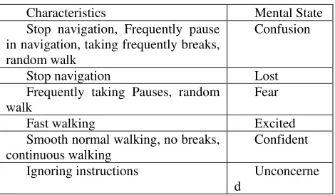
This Behavior Monitoring module continuously monitors the following types of participant’s behavior:
• Mental state
(Confusion/Fear/Lost/Excited/Confident/Unconcerned)
• Navigating style (normal/random walk)
During learning, participant’s navigating characteristics and style are continuously monitored and noted. Following are characteristics that decide the mental state of the participant.
Here, participant may have fear of failure in initial phase of learning, and not the fear of security.
According to the mental state of participant, the tone and content of instructions /assistance are fine tuned. For example, in Lost state, the participant is motivated to continue exploration and learning. While in Excited state, the participant is instructed to slow down to normal walk.
[image:3.612.317.552.311.448.2]Distance traversed and number of steps taken by the participant for each break and session are to be monitored and noted. If these two values are reducing or coming near the expected values, and if participant’s navigation style is normal than it is concluded that participant is confident and ready for assessment test. Participant is asked to go for assessment, if participant is founded to be confident, having memorized the path and landmarks for a task.
Table I. Mental state and characteristics of participant
Characteristics Mental State
Stop navigation, Frequently pause in navigation, taking frequently breaks, random walk
Confusion
Stop navigation Lost
Frequently taking Pauses, random walk
Fear
Fast walking Excited
Smooth normal walking, no breaks, continuous walking
Confident
Ignoring instructions Unconcerne
d
D. Assessment
In the final phase, once a participant gets confident and memorizes the path and landmarks between source and destination, she is allowed to go for assessment. In the assessment phase, participant navigates without system’s help in general and trying to reach the destination. Participant gets only contextual information. This is referred to as Un-Guided Navigation.
In case of wrong movement of user, help is to be provided i.e. AOC. This is system initiated action for assistance. Rather than saying – No, when participant does not use the exact route being sought, we attempt to understand the participant's current thinking about the environment. Through non-judgmental questioning, we lead the participant to construct new understanding and acquire new skills.
© 2010, IJARCS All Rights Reserved 32 assess the quality of learning, a penalty value is used in every
instance of an erroneous movement by the participant. Assistance is also provided in case the user asks for help (i.e. AAR) due to confusion and value of help-taken-count field is incremented. This has fewer penalties than the previous one. Participant’s navigation performance, such as path traversed, distance traversed, number of steps taken, number of times help provided and asked, number of times error made, and time taken to complete the task along with cumulative penalties are evaluated.
Navigation paths of the participant are evaluated quantitatively using bi-dimensional regression analysis developed by Tobler [13]. Bi-dimensional regression is applied to calculate bi-dimensional correlation coefficients (BCC). The participant’s performance is evaluated in terms of BCC between traversed path and optimal path. The sequence of objects falling on the traversed path and the positions where she seemed to have confusion (and hence took relatively longer time) are also conveyed to her. The participant has an option to get her performance feedback.
IV. QUALITY FACTORS FOR SPATIAL LEARNING
TECHNIQUES
We are presenting below various quality factors for evaluating effectiveness of VE-based spatial learning techniques. These factors have been categorized into (i) Quantitative factors, and (ii) Qualitative factors.
• Quantitative factors:
i. Navigation efficiency (measured through time taken, distance traversed, number of steps taken, number of times help taken and number of times help provided to complete the task)
ii. Speed of learning (measured through number of trials taken for learning)
iii. Landmark localization (measured through number of landmarks correctly identified during testing phase) iv. Accuracy (could be measured by comparing the
trajectory followed with respect to the optimal route) v. Spatial awareness (measured through number of times
help asked by participant and help provided to the participant in addition to landmarks correctly identified)
• Qualitative factors (measured through participants’ feedback)
i. Ease of learning (the ability of a novice user to easily go through the learning technique)
ii. Ease of use (the degree of complexity or cognitive load of the technique from the user’s point of view)
iii. Presence (the user’s sense of immersion or ‘being within’ the environment due to navigation)
iv. User comfort (lack of simulator sickness, dizziness, or nausea)
This list may not be exhaustive, but it is a good starting point for quantifying the effectiveness and performance of VE-Based spatial learning techniques. Some of the quality factors, such as speed, navigation efficiency and accuracy, are simple to measure quantitatively. Others, however, are difficult to measure due to their inherent subjective nature. To quantify these factors, standard questionnaires for factors such as ease of use [1], presence [12], and simulator sickness [4] are used. In order to quantify such factors, we prepared questionnaires for our experimental study.
V. PLANNING AND PROCEDURE FOR EXPERIMENT
A. Participants
Fourteen volunteers recruited as test participants for this research. All participants were between the ages 17 and 35 and unknown about place, have self-reported normal spatial learning and visual impairments. They were divided in to two groups — bind-folded sighted (8 participants), and blind (6 participants) — learned to form the cognitive maps by exploring a virtual environment of a place.
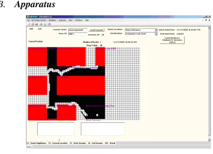
[image:4.612.317.526.190.341.2]B. Apparatus
Figure 2. Screen shot of Computer-simulated environments
To validate our NSL model, prototype system was developed. It is run on a laptop-based system with a 2 GHz Intel Core 2 Duo processor, 2 GB RAM and a 15” monitor. The virtual environment application is written in Java language using the JDK 1.5 API. We designed virtual environment based on ground floor of our institute (as shown in Figure 2), which has three corridors and eight landmarks/objects. It has one main entrance.
Our system lets the participant to form cognitive maps of unknown areas by exploring virtual environments. It can be considered an application of “learning-by-exploring” principle for acquisition of spatial knowledge and thereby formation of cognitive maps using VE. It guides the blind through speech by describing surroundings, guiding directions, and giving early information of a turning, crossings, etc. Additionally, occurrences of various events (e.g. arrival of a junction, arrival of object(s) of interest, etc.) are signaled by sound through speakers or headphones.
C. Procedure
© 2010, IJARCS All Rights Reserved 33 In first stage, i.e. familiarization stage, participants spent a
few minutes using the system in a simple virtual environment. The duration of such practice session was typically about 3 minutes. It helped the participants to familiarize themselves with the system, before the trials began. The goal of this stage was not to give enough time to participants to achieve competence.
After the familiarization stage, the following three tasks were given to participants:
• Exploration task:
Participants were asked to explore the VE and to complete the given task. Each participant repeated the task 4 times, taking maximum 5 minutes for each trial. Participants navigated the virtual space using first mode of navigation, i.e. they were provided the contextual cues and system help both.
• Object-localization task
The participants were asked to locate five landmarks as asked by the experimenter. This task took a maximum of 5 minutes. Participants navigated the virtual space using second mode of navigation, i.e. without system help.
• Target-object task.
The participants were asked to complete following task, i.e. “Go to the Computer Laboratory starting from Main Entrance”. The time allotted for this task was maximum 5 minutes. Participants navigated the virtual space using second mode of navigation.
D. Statistical Analysis
The independent variables used for the analysis included (i) trial number, (ii) mode of virtual navigation, and (iii) the type of participant’s blindness (blind and blind-folded sighted). The dependent variables were categorized into two categories:
(a) Number of objects located and identified correctly, and (b) (i) distance traversed, (ii) time taken, and (iii) number of pauses taken to complete the task of traversing 300-feet length of specified route. A t-test was used to analyze the experimental data with a level of significance ( ) taken as 0.05. The feedback from the participants was also analyzed using t-test.
VI. RESULT
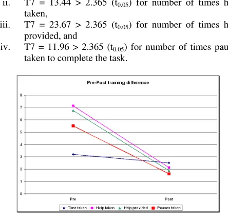
[image:5.612.310.523.51.141.2]Ho: The NSL model is not effective for spatial learning. Ha: The NSL model is effective for spatial learning.
Table II. Descriptive statistics measures for a Study
Parti- cipant
Param eters
Pre-training
Post-training
T7
Me an
SD Mea
n SD
BFS (8 in No., dof = 7)
Time taken (in min.)
3.2 0
0.49 2.51 0.28 3.46
Numb er of times help taken
7.1 3
0.83 2.13 0.64 13.44
Numb er of
6.7 5
0.46 1.88 0.35 23.67
times help provid ed Numb
er of times pauses
5.5 0
0.76 1.63 0.52 11.96
The null hypothesis (Ho) effectively implies that there is no difference between means of pre-training samples and post-training samples.
The pre-training and post-training values of the first four parameters have been collected and shown in Table-1, which are also depicted in Fig-3.
In Table-1, SD stands for standard deviation, and T7 is t-statistic to test the difference between means of pre-training and post-training samples (the suffix 7 in T7 indicates the dof). T7 is computed using the paired samples t-test to analyze the statistical significance of post-training gains.
The t-test table value for dof = 7 and = 0.05 is compared with the computed t-value (shown as T7) for all the four parameters as shown below:
i. T7 = 3.46 > 2.365 (t0.05) for time taken,
ii. T7 = 13.44 > 2.365 (t0.05) for number of times help
taken,
iii. T7 = 23.67 > 2.365 (t0.05) for number of times help
provided, and
iv. T7 = 11.96 > 2.365 (t0.05) for number of times pauses
[image:5.612.318.540.307.520.2]taken to complete the task.
Figure 3. Pre-post training difference in Trial-1 and Trial-4
Since the calculated values are more than table values for all the parameters, the null hypothesis is rejected. Thus, there is a significant difference (improvement) in post-training as against pre-training navigational performances of the user. That is, we can say with 95% confidence that the participants have been benefited by the training or alternatively we can say that the NSL model is effective for spatial learning.
The data for the object-localization task are presented in Table-2. As per t-test on this data, there is a 95% confidence level (5% significance level) that population mean will range between 3.91 (i.e. 4 landmarks) to 5.09 (i.e. 5 landmarks) for BFS. That is, the participants were able to successfully localize at least 4 landmarks out of 5 after the training.
Table III. Descriptive statistics measures of object-localization task
[image:5.612.54.268.556.735.2]© 2010, IJARCS All Rights Reserved 34
Min Max
BFS (8 in No.,
dof = 7)
4.50 0.75 3.91 5.09
Thus, the experimental results have conclusively indicated that our spatial learning technique (and assistive system based on our NSL model) results in effective development of cognitive maps leading thereby to the enhancement of mobility skills of the participants.
There was although a noticeable improvement in the non-visual spatial learning as shown above, but it does not provide a feeling of natural walking to participants. It is hypothesized that any device, which offers the feeling of natural walking, would be more acceptable and is likely to further enhance the quality of spatial learning. This was the major motivation to carry out experiments on UWP to first assess its acceptability and thereafter its effectiveness as a spatial learning system.
General comments and feedback:
The kind of general comments and feedback received from the participants is given below:
“The virtual movements did not become natural until 3-4 trials”.
“The exploration got easier progressively each time”. “I found it somewhat difficult to explore. As I explored, I got better”.
Although there was a general satisfaction among the participants, there were some comments indicating a scope for further improvements in the system. Such comments are given below:
“I had difficulty making immediate turns in the virtual environment”.
“Virtual walking through keyboard needs more cognitive efforts than real walking”.
VII. CONCLUSION
This model is effective to promote the development and online evaluation of cognitive maps of users. Knowledge based systems help to enhance capacity of machine or computer system to behave intelligently, similar to human being in some aspects at least. Machine based training simulators are equivalent or better than human trainers in terms of efficiency and effectiveness. Our Non-visual spatial learning (NSL) model provides computational framework for spatial knowledge representation, acquisition and assessment of the acquired spatial knowledge.
We are encouraged by results from our prototype implementation, which suggest that such non-visual spatial learning techniques would help visually impaired people to get effectively learned for independent navigation. The participants have benefited by the training, i.e. there were significant improvements in their post-training navigation performance. The experimental results and participants’ feedback have conclusively indicated that the assistive system based on our NSL model is very effective for independent spatial learning and thereby enhancement of mobility skills of VIP.
VIII. ACKNOWLEDGMENTS
This study is supported in part by the Education Directorate, Computer Society of India. Special thank to my students and colleagues for their support during experimental study.
IX. REFERENCES
[1] J. Chin, V. Diehl, and K. Norman, (1988). Development of an Instrument Measuring User Satisfaction of the Human-Computer Interface. Proceedings of CHI, 213-218.
[2] D. Clark-Carter, A. Heyes, and C. Howarth, (1986). The effect of non-visual preview upon the walking speed of visually impaired people. Ergonomics, 29 (12), pp.1575– 81.
[3] R. P. Darken, W.R. Cockayne, and D. Carmein, (1997). The Omni-Directional Treadmill: A Locomotion Device for Virtual Worlds. Proc. of UIST’97, pp. 213-221.
[4] R.S. Kennedy, N.E. Lane, K.S. Berbaum, and M.G. Lilienthal, (1993). Simulator Sickness Questionnaire: An enhanced method for quantifying simulator sickness. International Jour-nal of Aviation Psychology, 3:3 203-220.
[5] O. Lahav and D. Mioduser, (2003). A blind person's cognitive mapping of new spaces using a haptic virtual environment. Journal of Research in Special Education Needs. v3 i3. 172-177.
[6] P. Parente and G. Bishop, (2003). BATS: The Blind Audio Tactile Mapping System. Proc. of 41st Annual ACM Southeast Conference (ACMSE 2003), Savannah, Georgia.
[7] M. Rice, R. Jacobson, G. Golledge, and D. Jones, (2005). Design Considerations for Haptic and Auditory Map Interfaces. Cartography and Geographic Information Science, 32(4), October 2005, pp. 381-391.
[8] J. Sanchez and N. Baloian, (2005). Modelling Audio-based Virtual Environments for Children with Visual Disabilities. Proc. of the ED-Media Conference 2005, Montréal, Canada, AACE press, pp. 1652-1659.
[9] S.K. Semwal and D.L. Evans-Kamp, (2000). Virtual environments for visually impaired. Paper presented at the 2nd International Conference on Virtual worlds, Paris, France.
[10] A. W. Siegel and S.H. White, (1975). The development of spatial representations of large-scale environments. Advances in child development and behavior, 10, In H.W. Rees (Ed.), pp. 9-55, New York: Academic Press.
[11] M. Simonnet, R.D. Jacobson, S. Vieilledent, and J. Tisseau, (2009) SeaTouch: A Haptic and Auditory Maritime Environment for Non Visual Cognitive Mapping of Blind Sailors. In K. Stewart Hornsby et al. (Eds.): COSIT 2009, LNCS 5756, pp. 212–226. Springer-Verlag Berlin, Heidelberg
[12] M. Slater, M. Usoh, and A. Steed, (1995). Taking Steps: The Influence of a Walking Metaphor on Presence in Virtual Reality, ACM Transactions on Computer-Human Interaction, 2(3), 201-219.