n
a
a
Digital Terrain Model Data Structures
n .s
Li
Alias Abdul Rahman
a Jabatan Geoinformatik
a Fakul!i Ukur
Universi!i Teknologi Malaysia I.
Abstract
This paper describes pertinent digital terrain model data structures, namely, grid/raster, quadtree, and triangular irregular network. A basic concept of DIM data structure is also explained. The aspects of TIN storage, TIN data structure conversion, advantages and disadvantages of each structure are discussed. A complete data structure conversion program is also presented.
n.
1.0 INTRODUCTION
Digital Terrain Model (DIM) is used to represent the earth surface or part of the
Ir, surface digitally. Historically, DTM was introduced by engineers at Massachussetts Institute of Technology (MIT) in the late 1950's. Their definition of DTM is: "digital terrain model (DIM) is simply a statistical representation of continous surface of the ground by a large number of selected points with known x,y,z coordinates in an arbitrary coordinates field" (Kennie and Petrie,(1990)). The definition was based on the nature of the work at that point in time i.e. engineering. Today several terms begin to manifest and can be recognized as Digital Elevation Model (DEM), Digital Height Model (DHM), Digital Ground Model (DGM), Digital Terrain Model (DTM), and Digital Terrain Elevation Data (DTED). Dispite of the differing terms have been used all of them represent the same phenomena i.e. the topography of the earth surface.
2.0 DATA AND STRUCTURES
The pattern of DTM data could be regular or irregular. The regular may be in the form of square or rectangular grid while the irregular one may be based on triangular network of irregular size, shape and orientation. These DIM data could be structured
in different ways such as grid/raster, quadtree, and triangular irregular data
Alias Abdul Rahman
the character of the terrain phenomenon are things that will influence the data structuring. Data structure conversion(i.e. restructuring) may be necessary in order to optimize the processing.
The issue of structuring DTM data now becomes an interesting area to be investigated
especially in an integrated environment e.g. DTM+GIS. At this point in time, DTM
handling in GIS is not so efficient. Why? One of the major impediments is due to the data structuring. Thus a 'brilliant' data structure will greatly influences DTM data processing. Mark (1978) suggested that a considerable thought and care has to be taken if a data structure has to be designed or adopted, because, once chosen and
implemented, then often will be very difficult or expensive to modify. If they are
poorly designed then the system may be less efficient, and may caused some problems. Mark (1978) also suggested that the structures should be tailored to the terrain phenomenon. Another author, Radwan(1989) suggested that the most
appropriate DIM structure should be able to support a wide range of DIM
applications for terrain analysis, and able to accommodate, use, and explicitly represent critical features of morphological significance in addition to the standard DTM data i.e. spot heights, contours, and regular grid.
The following sections explain the three main DTM data structures in more detail.
2.1 Grid/raster data structure
Tradionally, this is the most frequently used data structure. The points (xyz coordinates) are normally arranged in a series of rows and coloumns or in xy cartisean system. One of the advantages of this structure is that it has an implicit definition of point topology where the neighbouring points can be found without additional computation. Also, offers a relatively compact storage and able to handle a fast data processing algorithm. This structure is widely used in image processing techniques.
However, the major drawback is that inability to accommodate relief changes in
rough terrain. Thus, in terms of storage space, the structure tend to occupy large space and highly redundant of data in flat terrain. Ambiguous height interpolation occurs in the case'where two diagonal points have the same heights(O'Callaghan and Mark,(1984»). This problem is particularly noticeable, for example, when deriVing drainage network in hydrological modelling, and also in contour threading.
2.2 Quadtree and DTM data
progressive sampling can be stored and structured in quadtree. Another approach is to use octree, sometimes known as 3D extension of a quadtree(Wen, 1991).
2.3 Advantage and disadvantage of quadtree DTM
Since quadtree is a grid-based structure and has variable resolution, and in many ways related to the progressive sampling, thus redundance of grids data can be avoided particularly in flat terrain and eventually need less storage space. Waugh(1986), Mark et al(1989), and Mark(1986) suggested that quadtree is not very efficient structure to represent grid DTM data, continous surface, and unclassified imagery data. This is due to the fact that the neighbouring cells of these data seldom have identical values. Another major drawback is that difficult to modify any changes to the pattern of the data, requires recalculation of the quadtree. In terms of storage space, quadtree reduces quite significant compared to the normal DTM data structuring e.g. grid.
3.0 TRIANGULAR IRREGULAR NETWORK(TIN)
TIN data structure is increasingly and widely used in terrain modelling. Peucker et al(1978), and Peuquet(1990) worked with this data structure, and noted that all measured data was used directly since these data form triangle's nodes. Then, these nodes are used to interpolate and construct any DTM products e.g. contours. A network of triangles offers a relatively easy way of incorporating breaklines, faultlines, drainage lines, thus tailored to the terrain variations.
3.1 TIN Storage
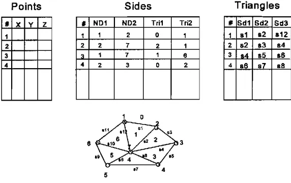
TIN data can be stored in several methods, namely, triangle-by-triangle, points and the neighbours, and side-based.
• 1'fiangle-by·triangle.
Itis a record of triangle number, xyz coordinates of the three nodes, and neighbouring
triangles.
• Nodes and their neighbours.
An alternative to the above structure, it is a record of node ill number, the xyz coordinates, and the neighbouring nodes.
• Triangle sides
Alias Abdul Rahman
Triangle•
Nod••
• , _Ivv.\ A{vv.' "
D Coord Ne' hb urs
Figure 1 Triangle and node based data structures
Points Sides Triangles
.Ir y Z 1
2 3
•
•
N01 ND2 Trl1 Tri21 1 2 0 1
2 2 7 2 1
• 1 7 1
•
•
2 3 0 2". Sd1 Sd2 Sd3
1 .1 .2 .'2
2 .2 • 3
••
3
••
.5 .64 .6 .7 .6
o
•
35
To
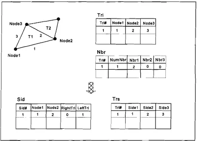
3.2 Data structure conversion
In certain situations, it is good to have a capability to convert from one data structure to another format e.g. grid to TIN and vice versa. This is due to the fact that not all data structure may satisfy some processing algorithms e.g. contour threading, and able to incorporate some important terrain phenomena. Weibel and Heller(1991) also noted that a flexible DTM system should have an ability to switch to different data structure. For example, one may want to produce contours from TIN data which is structured in triangle-by-triangle based. Then, in order to make the threading faster, the structure should be converted to 'triangle sides based'. A data structure conversion
program was developed by the author, see a complete source code in Appendix A.
This program is able to handle up to 5000 triangles.
Sid
Sid# Node1 Node2 RightTri LeftTrl
_..1. 2 0
N'~de3
T21
3 T1 2
Node2
f
Node1
2
2
Nbr1
Tri# Node1 Node2
Tri
1 1
Nbr
I Tri#~mNbr
Trs
Tri# Side1
L
o 0
I
- - .Nbr2
Nb~
3
Node3
Side2 Side3
2 3
Figure 3 Triangle-based to Side-based data structure
4.0 CONCLUSION
Alias Abdul Rahman
References
KENNIE,T.J.M. and G.PETRIE, (1990), "Introduction to Terrain Modelling - application fields and terminology", In: Terrain Modelling In Surveying and Civil Engineering, Edited by G.Petrie and T.J.M.Kennie, Whittles Publishing, pp. 1-3.
MARK,D.M., (1978), "Concept of Data Structure for Digital Terrain Models", ASP/ACSM Proceeding of
Digital Terrain ModelsroW) Symposium. St.Louis, Missouri, pp. 24-31.
MARK,D.M., (1986), "The Use of Quadtrees in Geographic Information Systems and Spatial Data Handling", AUTQCARTQ LONDON Progwdings. Edited by M.Blakemore, VoU, pp. 517-526.
O'CALLAGHAN,I.F. and D.M.MARK, (1984), "The Extraction of Drainage Networks from Digital Elevation Data", Computer Vision.Graphics. and Image Processing, 28, pp. 323-344.
PUECKER,T.K., (1978), "Data Structures for Digital Terrain Models: Discussion and Comparison", ht..lIl1
Myanced Stucly Symposjum OD Topological Data Structures for Geographical Information Systems
Harvard Paper on Geographical Information Systems, Edited by G.Dutton, Vol. 5
PUECKER,T.K.,RJ.FOWLER,J.J.LITTLE, and D.M.MARK, (1978), "The Triangulated Irregular Network",
ASP Proceedings of Digital Terrain Modds(PIMl ~pQsium.St.Louis, Missouri, pp. 516-540.
PUEQUET,D.J., (1990), "A Conceptual Framework and Comparison of Spatial Data Models", In;
Introductox:y Readings in Geographical Information Systems,Edited by D.J.Peuquet and D.F.Marble, Taylor
& Francis Publication, pp. 250-285.
RADWAN,M.M., (1989 b), "Concept of Digital Terrain Relief Modelling in TopographiC Database", Bakosurtanal, Indonesia.
SALAMANCA, S.c.P, (1990), "Quadtrees Data Structure For Handling Large Data Sets of Multi-Resolution Nature", M.Sc. Thesis, lTC, Enschede, The Netherlands.
SAMET,H., (1984), "The Quadtree and Related Hierarchical Data Structures", ACM Computing Surveys. Vol.I6, No.2, pp. 187-260.
WAUGH,T.C., (1986), "A Response tQ Recent Papers and Articles on the Use of Quadtrees for Geographical Information Systems", Proceedings of Second Int. Symposium on Spatial Data Handling. Seattle, Washington, pp. 33-37.