12 TRAFFIC AND TRANSPORTATION 12.1 AN OVERVIEW
The original plan of the city was based on the gridiron defined by a system of seven types of roads, which was called the 7Vs. The system was designed to provide safe mobility to children and pedestrians within and between the sectors, while also permitting the benefits of fast movement for vehicular traffic. Based on the problems being faced by European cities after the industrial revolution, Le Corbusier intended to prevent the traffic congestion and pollution problems caused by the growth of the private motor car while simultaneously utilising the benefits the technology offered. Prevention of vehicular traffic jams on the roads designed for uninterrupted fast mobility was to be achieved by having an efficient system of public bus transport. Sixty years later, although most elements of the original circulation system remain intact, it is the private car which rules the roost today. The pedestrian pathways for linking different sectors through open green spaces from north to south have largely remained on paper. Instead of cycle tracks going through the open spaces similarly connecting different sectors, some cycle tracks have been laid along the V3s dividing sectors but even these are poorly planned or incomplete, and in any case, do not provide safe continuity across the fast traffic roads.
With the city now having the highest per capita ownership of motorised vehicles in the country, and a dramatic increase in daily floating traffic from the extensive urbanisation which has taken place around the city, Chandigarh today faces the very problems that the carefully designed original Plan was meant to avoid. Pedestrians and cyclists can no longer move around the city safely as the motor car has become the prime determinant for traffic regulations and barriers across roads. Road widening has been encroaching on pedestrian pathways and many open spaces are getting encroached for car parking.
Travel in the city has become more risky with accident rates having gone up. the number of persons killed in road accidents has also gone up. This has tended to impact the poor more severely as many of those killed or injured are cyclists’/pedestrians. Increased use of personal vehicles has also lead to air pollution.
12 TRAFFIC AND TRANSPORTATION 12.1 AN OVERVIEW
The original plan of the city was based on the gridiron defined by a system of seven types of roads, which was called the 7Vs. The system was designed to provide safe mobility to children and pedestrians within and between the sectors, while also permitting the benefits of fast movement for vehicular traffic. Based on the problems being faced by European cities after the industrial revolution, Le Corbusier intended to prevent the traffic congestion and pollution problems caused by the growth of the private motor car while simultaneously utilising the benefits the technology offered. Prevention of vehicular traffic jams on the roads designed for uninterrupted fast mobility was to be achieved by having an efficient system of public bus transport. Sixty years later, although most elements of the original circulation system remain intact, it is the private car which rules the roost today. The pedestrian pathways for linking different sectors through open green spaces from north to south have largely remained on paper. Instead of cycle tracks going through the open spaces similarly connecting different sectors, some cycle tracks have been laid along the V3s dividing sectors but even these are poorly planned or incomplete, and in any case, do not provide safe continuity across the fast traffic roads.
With the city now having the highest per capita ownership of motorised vehicles in the country, and a dramatic increase in daily floating traffic from the extensive urbanisation which has taken place around the city, Chandigarh today faces the very problems that the carefully designed original Plan was meant to avoid. Pedestrians and cyclists can no longer move around the city safely as the motor car has become the prime determinant for traffic regulations and barriers across roads. Road widening has been encroaching on pedestrian pathways and many open spaces are getting encroached for car
parking. SKETCH BY LE CORBUSIER SHOWING 7V CONCEPT
12.2 REGIONAL CONNECTIVITY OF THE CITY
The city has good connectivity with the other surrounding region by road, rail and air.
Road connectivity
Chandigarh is well connected with the national capital by NH-21 which passes through the city. The four laning of the highway and the construction of a number of flyovers and bypasses has made it a fast travel corridor reducing travel time considerably. The city is also well connected to the major towns in Punjab, Haryana and Himachal Pradesh by road.
KALKA
AIRPORT
RAILWAY station PINJORE
CHANDIGARH
MAP SHOWING REGIONAL CONNECTIVITY
The recent upgradation of the National Highway – leading to Shimla and the construction of a bypass around the towns of Pinjore and Kalka have removed the major traffic bottleneck in the road to Shimla .
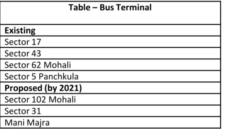
The Inter State Bus Terminus (ISBT) in Sector 17 was the main ISBT for a number of decades till the recent construction of the ISBT in Sector 43. The new ISBT provides Interstate bus connectivity on all routes except for a few long route buses plying from ISBT Sector-17. The ISBT in Sector 17 will eventually be used as a local bus terminus.
MAP SHOWING REGIONAL CONNECTIVITY
BUS STAND, SECTOR-17
INTER STATE BUS TERMINUS, SECTOR-43
RAILWAY CONNECTIVITY
The rail connectivity to the city is through twin track railway lines from Delhi and Mumbai upto Ambala , a single track broad gauge thereafter upto Kalka and a narrow-gauge single track between Kalka and Shimla having heritage value. The recently built single track Chandigarh to Morinda railway line provides rail connectivity to Punjab.
Besides serving the city, Chandigarh‘s railway station located in the north-eastern periphery of the city near the Industrial Area also serves the goods and the passenger traffic of the neighbouring region including the towns of Panchkula and Mohali. Direct access to the railway station from the Panchkula side has been facilitated.
With the increase in the frequency and number of trains together with faster speed and greater comfort, rail has become an important mode of transport.
AIR CONNECTIVITY
Located on the south eastern corner of the city and built in the fifties, Chandigarh’s airport remains under the Ministry of Defence but also serves as a domestic airport. Over the years, direct flights to Delhi, Mumbai, Jammu, Srinagar, Jaipur, Leh and Bengaluru have been introduced with a daily footfall of around 2,000 passengers at the local airport. The proposal to start international flights has been under active consideration for some time.
A new, fully air-conditioned terminal building, equipped with modern facilities, has been built recently with a capacity to accommodate 500 passengers at a time. Chandigarh’s airport today is among the best airports in the country in the category of B class cities.
The airport is in the process of being further upgraded as an international airport as a joint venture of Punjab, Haryana and the Airport Authority of India on 300 acres of land in Punjab.
CHANDIGARH RAILWAY STATION RAILWAY CONNECTIVITY
The rail connectivity to the city is through twin track railway lines from Delhi and Mumbai upto Ambala , a single track broad gauge thereafter upto Kalka and a narrow-gauge single track between Kalka and Shimla having heritage value. The recently built single track Chandigarh to Morinda railway line provides rail connectivity to Punjab.
Besides serving the city, Chandigarh‘s railway station located in the north-eastern periphery of the city near the Industrial Area also serves the goods and the passenger traffic of the neighbouring region including the towns of Panchkula and Mohali. Direct access to the railway station from the Panchkula side has been facilitated.
With the increase in the frequency and number of trains together with faster speed and greater comfort, rail has become an important mode of transport.
AIR CONNECTIVITY
Located on the south eastern corner of the city and built in the fifties, Chandigarh’s airport remains under the Ministry of Defence but also serves as a domestic airport. Over the years, direct flights to Delhi, Mumbai, Jammu, Srinagar, Jaipur, Leh and Bengaluru have been introduced with a daily footfall of around 2,000 passengers at the local airport. The proposal to start international flights has been under active consideration for some time.
A new, fully air-conditioned terminal building, equipped with modern facilities, has been built recently with a capacity to accommodate 500 passengers at a time. Chandigarh’s airport today is among the best airports in the country in the category of B class cities.
The airport is in the process of being further upgraded as an international airport as a joint venture of Punjab, Haryana and the Airport Authority of India on 300 acres of land in Punjab.
OLD TERMINAL OF CHANDIGARH AIRPORT
254
NEW TERMINAL OF CHANDIGARH AIRPORT
TYPE FUNCTION
V1 Roads connecting Chandigarh with other cities in the region . The Madhya Marg and Dakshin Marg merge with the V1s leading to Kalka and Ambala respectively.
V2 The major avenues of Chandigarh, with important institutional and commercial buildings located on them. Madhya Marg, Dakshin Marg, Jan Marg, Himalaya Marg, Uttar Marg and Purv Marg are important examples of these.
V3 Roads between sectors for fast moving vehicular traffic. Each sector is surrounded either by a V2 or V3.
V4 Shopping streets cutting through sectors with shops on their southern side.
TABLE 1: THE HIERARCHICAL NETWORK OF 7VS (WHICH HAS INCREASED TO 8) HAD THE FOLLOWING FUNCTIONS IN CHANDIGARH’S ORIGINAL PLAN :
12.3 ROAD NETWORK OF 7VS WITHIN THE CITY
V4 Shopping streets cutting through sectors with shops on their southern side. V5 Circulation roads within sectors .
V6 Roads providing access to houses .
V7 Foot paths through green belts enabling pedestrians to cross sectors without having to cross vehicular traffic and cycle tracks.
V8 Cycle tracks through green spaces
Buses were to ply only along V2,V3 and V4 roads. Each sector was to have only four entry points from V3s no direct entry to houses was permitted from these roads.
PLAN P1: ORIGINAL CIRCULATION NETWORK AND TRANSPORTATION NODES RAILWAY STATION TO AMBALA TO MULLANPUR BS SECTOR - 17 AIRPORT TO AMBALA TO M O RIN DA ISBT, SECTOR 43 256
PRESENT STATUS OF ROAD NETWORK
The 7V Circulation System has served the city well for decades. However the same is now under extreme pressure, both internal and external, which has begun to affect its efficiency.
The concept of the self contained neighbourhood intended to meet all the daily needs of the residents within walking distance without having to go outside the sector has not been fully successful ; freedom of choice for schools, shopping centres etc. outside the sectors results in inter sector movement of fast and slow vehicles across the city.
Further, Le Corbusier’s concept of the 7Vs has not been fully implemented.
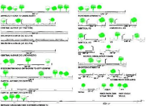
Detailed planning of the road network/road sections of each category of road was done in great detail by the original team including road carriageways, pedestrian and cycle tracks, tree plantation, and street lighting. Phased development of the system was planned to enable the infrastructure to keep pace with the growth of the town. ReferFigure 4andFigure 5.
Pedestrian pathways and cycle tracks not fully built
The V7s and V8s intended exclusively for the pedestrians and the cyclists respectively crossing road intersections by underpasses have not been implemented so far.
Figure 4
: R
oad sections 1
stphase development
PRESENT STATUS OF ROAD NETWORK
The 7V Circulation System has served the city well for decades. However the same is now under extreme pressure, both internal and external, which has begun to affect its efficiency.
The concept of the self contained neighbourhood intended to meet all the daily needs of the residents within walking distance without having to go outside the sector has not been fully successful ; freedom of choice for schools, shopping centres etc. outside the sectors results in inter sector movement of fast and slow vehicles across the city.
Further, Le Corbusier’s concept of the 7Vs has not been fully implemented.
Detailed planning of the road network/road sections of each category of road was done in great detail by the original team including road carriageways, pedestrian and cycle tracks, tree plantation, and street lighting. Phased development of the system was planned to enable the infrastructure to keep pace with the growth of the town. ReferFigure 4andFigure 5.
Pedestrian pathways and cycle tracks not fully built
The V7s and V8s intended exclusively for the pedestrians and the cyclists respectively crossing road intersections by underpasses have not been implemented so far.
Figure 5
: R
oad sections 2
ndphase development
• The pathways that have been laid are poorly maintained and have trees, storm water drainage and other obstructions which compel pedestrians /cyclists to move on roads thereby defeating the very concept of dedicated space for them.
• Underpasses to connect V4 shopping streets across V3s/V2s have also not been implemented. The built environment and the road junctions also do not permit such interconnectivity at this stage . • Four phased development of roundabouts has been carried out
only upto the second phase. In most cases slip roads were built only recently. In some cases no space has been left for slip roads making them non feasible now.
PEDESTRIAN SPACE ENCROACHED BY TREES, UTILITIES WHICH DEFEATS THE PURPOSE OF DEDICATED FOOTPATHS
POOR CONDITION OF ROADS AND CYCLE TRACKS
LANDSCAPED ROUNDABOUTS OF CHANDIGARH DRAWING OF FOUR PHASED DEVELOPMENT OF ROUNDABOUTS
Chandigarh’s road network is under intense pressure today due to increase in population, explosive growth in the number of private vehicles which has increased the number of personalised vehicles, partly due to the absence of an efficient and reliable public transport system. There are limitations on the road space that can be provided within the existing built up environment.
Expansion of the city to the periphery of UT and permitted land use changes have resulted in new travel corridors.(Refer chapter - 13 on Land Use )
New roads to provide / improve connectivity of the developments in the peripheral areas generating criss-cross movement across the city and increased inter sector commuting.
• The 7V and the sectoral concepts have not been followed while urbanising the rural areas .
• Urban development across the Patiali ki Rao and Sukhna Choe has been piecemeal, with some areas having poor accessibility.
• No provision has been made for pedestrians /cyclists in trans choe developments or on the high level bridges constructed over the choes despite many commuters using these modes . Large volumes of inter-city traffic
There is now a lot of intercity vehicular traffic from the neighbouring states which have strong daily interaction with the city. The emergence of the new towns of Mullanpur and Naya Gaon adjoining the city, and the planned expansion of existing towns in the neighbouring states are also likely to generate new travel corridors exerting further pressure on the city’s arteries. Consequently, the well defined planned hierarchy of roads has been disturbed both due to intercity traffic and increased traffic within the city, including that from the wholesale markets .
High volumes of through traffic across the city:
The total daily (24 hour) traffic studies at outer cordon points indicate that about 1,52,650 vehicles enter or leave Chandigarh Urban Complex on a typical working day. There is also high through passenger and freight traffic across the city. Madhya Marg is envisaged to be the worst affected of the roads since it provides the shortest and the direct connection between the towns of Punjab Mullanpur /Kharar /Anandpur Sahib and Baddi in Himachal on the West and the eastern towns of Manimajra, and towns of Panchkula, Panchkula Extension, Pinjore Kalka, Chandimandir Cantonment in Haryana and further to the towns of Parwanoo, Shimla etc. in the state of Himachal Pardesh. The through traffic across the city had added to the congestion on the road.
As per the surveys conducted by M/s Rites in 2008, the daily total inter city passenger traffic with the Chandigarh Urban Complex is 4.93 lakh trips (cars, 2 wheelers, auto rickshaws and buses) about 1.41 lakh of which comprise through trips which is 28.7% of the total traffic. The demand for through traffic is shown inFigure 10. Of the total traffic of 26934 vehicles (LCV, Trucks and MAV) about 11062 vehicles are through which is about 41% of total traffic. Traffic desire for through movement is shown inFigure 11. This also indicates the need a bypass road to around Chandigarh Urban Complex. With business as usual scenario, the Volume /Capacity (V/C )ratios on all major corridors are expected to be well above ‘1’ by year 2021. The situation is likely to worsen considering the high growth anticipated in CUC and nearby towns.
12.4 PRESENT TRAFFIC CHARACTERISTICS AND PROBLEMS
Chandigarh’s road network is under intense pressure today due to increase in population, explosive growth in the number of private vehicles which has increased the number of personalised vehicles, partly due to the absence of an efficient and reliable public transport system. There are limitations on the road space that can be provided within the existing built up environment.
Expansion of the city to the periphery of UT and permitted land use changes have resulted in new travel corridors.(Refer chapter - 13 on Land Use )
New roads to provide / improve connectivity of the developments in the peripheral areas generating criss-cross movement across the city and increased inter sector commuting.
• The 7V and the sectoral concepts have not been followed while urbanising the rural areas .
• Urban development across the Patiali ki Rao and Sukhna Choe has been piecemeal, with some areas having poor accessibility.
• No provision has been made for pedestrians /cyclists in trans choe developments or on the high level bridges constructed over the choes despite many commuters using these modes . Large volumes of inter-city traffic
There is now a lot of intercity vehicular traffic from the neighbouring states which have strong daily interaction with the city. The emergence of the new towns of Mullanpur and Naya Gaon adjoining the city, and the planned expansion of existing towns in the neighbouring states are also likely to generate new travel corridors exerting further pressure on the city’s arteries. Consequently, the well defined planned hierarchy of roads has been disturbed both due to intercity traffic and increased traffic within the city, including that from the wholesale markets .
High volumes of through traffic across the city:
The total daily (24 hour) traffic studies at outer cordon points indicate that about 1,52,650 vehicles enter or leave Chandigarh Urban Complex on a typical working day. There is also high through passenger and freight traffic across the city. Madhya Marg is envisaged to be the worst affected of the roads since it provides the shortest and the direct connection between the towns of Punjab Mullanpur /Kharar /Anandpur Sahib and Baddi in Himachal on the West and the eastern towns of Manimajra, and towns of Panchkula, Panchkula Extension, Pinjore Kalka, Chandimandir Cantonment in Haryana and further to the towns of Parwanoo, Shimla etc. in the state of Himachal Pardesh. The through traffic across the city had added to the congestion on the road.
As per the surveys conducted by M/s Rites in 2008, the daily total inter city passenger traffic with the Chandigarh Urban Complex is 4.93 lakh trips (cars, 2 wheelers, auto rickshaws and buses) about 1.41 lakh of which comprise through trips which is 28.7% of the total traffic. The demand for through traffic is shown inFigure 10. Of the total traffic of 26934 vehicles (LCV, Trucks and MAV) about 11062 vehicles are through which is about 41% of total traffic. Traffic desire for through movement is shown inFigure 11. This also indicates the need a bypass road to around Chandigarh Urban Complex. With business as usual scenario, the Volume /Capacity (V/C )ratios on all major corridors are expected to be well above ‘1’ by year 2021. The situation is likely to worsen considering the high growth anticipated in CUC and nearby towns.
Figure 10 Figure 11
DESIRE PATTERNS OF INTER-CITY PASSENGERS
IN THE STUDY AREA (2008) DESIRE PATTERN OF INTER-CITY GOODS TRAFFICIN THE STUDY AREA (2008)
• Traffic composition on roads indicates a very high share of two wheelers on most roads. The share of cars is also growing. On some of the roads, the share of two wheelers and cars in total traffic is more than 80% indicating inadequacy of the public transport system.
• The household travel surveys indicate high ownership of carsand two wheelers.
• 86% of households own at least one car or two-wheeler.
• At present,modal split in favour of public transport is only 16% of total motorised person trips which is much lower than that recommended in the National Urban Transport Policy. This is due to the high growth rate in personalized motor vehicles, This low modal share is likely to fall further unless an effective public transport system is put in place at the earliest.
• The city has the highest car per capita of motorised vehicles in the country. There were more than 6 lakh motor vehicles registered in Chandigarh in 2005. Two wheelers account for around 71.5% and cars/jeeps around 27% of the total vehicles registered.
HEAVY TRAFFIC JAMS ON THE CITY ROADS
261
CATTLE OBSTRUCTING TRAFFIC IN PERI URBAN AREAS
7V CONCEPT NOT ADOPTED IN RURAL AREAS
Railway line an obstruction to the smooth flow of traffic: The railway line passing through the city is a hindrance to seamless connectivity in the absence of ROB’s /RUB’s Manimajra, Mauli Jagran, Panchkula Town located across the railway line and daily commuters are put to great inconvenience at railway crossings.
Additions made to the road infrastructure
The following new roads have been planned /built to improve the connectivity of the areas mentioned above.
The Vertical V3s have been extended up to the interstate boundary to carve out additional sectors and connect with the V3’s of Mohali which have replicated and synchronised the 7V network of Chandigarh .
12.5 INTERVENTIONS / ADDITIONS MADE TO THE ROAD NETWORK OF THE ORIGINAL PLAN
PLAN P2 EXTENSION OF VERTICAL V3S TO THE INTER STATE BORDERS
Railway line an obstruction to the smooth flow of traffic:
262
Pressure on Madhya Marg
Madhya Marg with the high level bridge across the railway line and Sukhna Choe is at present the only encumbrance free direct approach to trans Sukhna Choe areas and as such attracts high traffic volumes which lead to high traffic congestion especially during working hours .
Traffic surveys conducted by RITES for preparing the Comprehensive Mobility Plan indicate that
⁻ Road network capacity in CUC is adequate for now but major travel corridors Madhya Marg, Udyog Path, Dakshin Marg are beginning to become congested.
⁻ Many junctions particularly on Madhya Marg, Himalaya Marg, Dakshin Marg, Jan Marg, Purv Marg, Udyog Path etc have very high approach traffic volumes and most of the junctions with rotaries have exceeded their capacity. With expected growth of traffic, the situation at these junctions is likely to deteriorate fast.
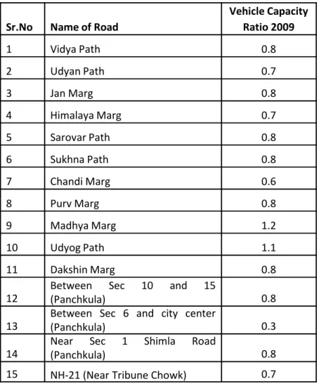
Table 1 shows Vehicular Capacity ratios of various major roads in the study area. It can be seen from the table that in 2009 most of the roads had V/C ratios less than 1.0 except Madhya Marg and Udyog Path.
Although Volume/capacity (VC) ratio on most of the roads are less than 1, these are fast approaching their full capacity. Some roads are already serving traffic volumes more than the capacity. The situation is likely to worsen considerably.
Under these circumstances corridors like Vidya Path, Himalaya Marg, Madhya Marg, Udyog Path, Purv Marg, Vikas Marg and Dakshin Marg will get choked by personalized modes such as cars and two wheelers by 2021 and beyond. With most of the roads having already been widened to their full capacity, this indicates the need of augmenting road capacity by planning high capacity mass transport systems.
Sr.No Name of Road
Vehicle Capacity Ratio 2009 1 Vidya Path 0.8 2 Udyan Path 0.7 3 Jan Marg 0.8 4 Himalaya Marg 0.7 5 Sarovar Path 0.8 6 Sukhna Path 0.8 7 Chandi Marg 0.6 8 Purv Marg 0.8
TABLE T1:TRAFFIC SURVEYS CONDUCTED BY RITES Refer “Plan 1” on Page 5
Traffic surveys conducted by RITES for preparing the Comprehensive Mobility Plan indicate that
⁻ Road network capacity in CUC is adequate for now but major travel corridors Madhya Marg, Udyog Path, Dakshin Marg are beginning to become congested.
⁻ Many junctions particularly on Madhya Marg, Himalaya Marg, Dakshin Marg, Jan Marg, Purv Marg, Udyog Path etc have very high approach traffic volumes and most of the junctions with rotaries have exceeded their capacity. With expected growth of traffic, the situation at these junctions is likely to deteriorate fast.
Table 1 shows Vehicular Capacity ratios of various major roads in the study area. It can be seen from the table that in 2009 most of the roads had V/C ratios less than 1.0 except Madhya Marg and Udyog Path.
Although Volume/capacity (VC) ratio on most of the roads are less than 1, these are fast approaching their full capacity. Some roads are already serving traffic volumes more than the capacity. The situation is likely to worsen considerably.
Under these circumstances corridors like Vidya Path, Himalaya Marg, Madhya Marg, Udyog Path, Purv Marg, Vikas Marg and Dakshin Marg will get choked by personalized modes such as cars and two wheelers by 2021 and beyond. With most of the roads having already been widened to their full capacity, this indicates the need of augmenting road capacity by planning high capacity mass transport systems.
8 Purv Marg 0.8
9 Madhya Marg 1.2
10 Udyog Path 1.1
11 Dakshin Marg 0.8
12 Between(Panchkula)Sec 10 and 15 0.8 13 Between Sec 6 and city center(Panchkula) 0.3 14 Near(Panchkula)Sec 1 Shimla Road 0.8
15 NH-21 (Near Tribune Chowk) 0.7
Route No. 1 (alternative route to Panchkula )- A 30.48.(100 ft.) wide road from Purv Marg to Sector 17/18 junction of Panchkula via Industrial Area Phase-I/CTU workshop/cremation ground has been constructed . The road width varies from 21.34 to 30.48 m within the Industrial Area Phase-I due to constraints of adjoining buildings. At present there is obstruction of railway level crossing. Route No. 2 -A 60.96 m wide road (with 10.5 m wide metalled road and 5 meters wide slow carriageway on either side) from Hallomajra Chowk to Industrial Area in Panchkula via forest area/Industrial Area, Phase-III (Raipur Kalan), has been planned. At present 7m wide metalled road on either side of central verge has been constructed, however, the commuters are inconvenienced by a surface rail crossing (at Jn. 125) and the absence of pedestrian/cycle tracks.
Route No.3 –A 30.48 m wide road (with dual carriageway on either side) from Saint Kabir crossing (Chandi Path) to Fun Republic (Manimajra) via behind the Police Lines /railway crossing N126/Police Station (Manimajra)/Fun Republic has been planned/constructed. However, the RUB pedestrian paths/cycle tracks are yet to be constructed. The width of the road varies from 30.48m to 15.84m due to constraints posed by existing buildings in Manimajra along the road.
Widening of road carriageways beyond the ultimate prescribed in the road section to accommodate more cars. This has however been at the expense of the pedestrians and the cyclists and needs to be avoided in future .
Roundabouts replaced by ATC lights
The total replacement of roundabouts with ATC lights in a few cases such as the Press Chowk and the Transport Chowk along Madhya Marg has not been appreciated by the city residents who have a strong affinity with the city’s beautifully landscaped roundabouts. ATC lightshave been installed at various junctions (Refer Plan 2)
Central verge constructed along V4 roads tosegregate movement in opposite directions and to improve flow of traffic. This has however defeated the intended function of the V4 roads planned as slow carriageways.
Closure of the central verge along V2/V3 roads between
intersections to prevent crisis cross movement and accidents. This again has given priority to cars at the cost of the pedestrians, cyclists and other non motorised modes of mobility (such as cycle rickshaws and horse carts )
ROUNDABOUTS WITH
TRAFFIC LIGHTS ROUNDABOUTS REPLACEDBY TRAFFIC LIGHTS Route No. 1 (alternative route to Panchkula )- A 30.48.(100 ft.)
wide road from Purv Marg to Sector 17/18 junction of Panchkula via Industrial Area Phase-I/CTU workshop/cremation ground has been constructed . The road width varies from 21.34 to 30.48 m within the Industrial Area Phase-I due to constraints of adjoining buildings. At present there is obstruction of railway level crossing. Route No. 2 -A 60.96 m wide road (with 10.5 m wide metalled road and 5 meters wide slow carriageway on either side) from Hallomajra Chowk to Industrial Area in Panchkula via forest area/Industrial Area, Phase-III (Raipur Kalan), has been planned. At present 7m wide metalled road on either side of central verge has been constructed, however, the commuters are inconvenienced by a surface rail crossing (at Jn. 125) and the absence of pedestrian/cycle tracks.
Route No.3 –A 30.48 m wide road (with dual carriageway on either side) from Saint Kabir crossing (Chandi Path) to Fun Republic (Manimajra) via behind the Police Lines /railway crossing N126/Police Station (Manimajra)/Fun Republic has been planned/constructed. However, the RUB pedestrian paths/cycle tracks are yet to be constructed. The width of the road varies from 30.48m to 15.84m due to constraints posed by existing buildings in Manimajra along the road.
Widening of road carriageways beyond the ultimate prescribed in the road section to accommodate more cars. This has however been at the expense of the pedestrians and the cyclists and needs to be avoided in future .
Roundabouts replaced by ATC lights
The total replacement of roundabouts with ATC lights in a few cases such as the Press Chowk and the Transport Chowk along Madhya Marg has not been appreciated by the city residents who have a strong affinity with the city’s beautifully landscaped roundabouts. ATC lightshave been installed at various junctions (Refer Plan 2)
Central verge constructed along V4 roads tosegregate movement in opposite directions and to improve flow of traffic. This has however defeated the intended function of the V4 roads planned as slow carriageways.
Closure of the central verge along V2/V3 roads between
intersections to prevent crisis cross movement and accidents. This again has given priority to cars at the cost of the pedestrians, cyclists and other non motorised modes of mobility (such as cycle rickshaws and horse carts )
264
Vision
“One day people will come to Chandigarh to see the park wherein one does not see the automobile, where one sees the nature (a very impressive nature ).”
Le Corbusier The Chandigarh Master Plan 2031 vision for the traffic and transportation in Chandigarh is in sync with above quotation. The GOIs National Urban Transport Policy advocates people centric well contained city with efficient people-friendly transport system with minimum travel time & maximum safety and comfort that aims at reducing dependence on cars, with widespread use of non-motorised modes and mass rapid transit system.
GOALS
• To improve connectivity and travel throughout the city and its region.
• To improve mobility within neighborhoods, wards, zones and satellite towns to address inner- and inter-city transportation needs to offer viable and reliable transportation options. At the same time the facility provided should be optimally used.
• Maintaining Chandigarh’s outstanding universal appeal of a green, clean and spacious town which does not buckle under pressure.
• Adopting best practices -Use of green and energy efficient transportation modes which cause least damage to the environment.
• Sixty to seventy percent of total trips should be made by public transport, with one (or two) modal changes.
• Maximum population should be served by public transport. • Trip origins and destination to be within 500m of public
transport terminal and stops.
• Safe and convenient pedestrian/NMV facilities throughout the urban area.
• Safe bicycle lanes shall be provided to reach the public transport system, with secure bicycle parking provided for those who do not have access to public transport within walking distance.
• Integrated urban land use and transport system resulting in efficient and sustainable mobility for everyone and provide greater accessibility to opportunities (e.g. employment, education, health, goods, and other services).
12.6 PLANNING FOR THE FUTURE – TRAFFIC AND TRANSPORT PLANNING
Vision
“One day people will come to Chandigarh to see the park wherein one does not see the automobile, where one sees the nature (a very impressive nature ).”
Le Corbusier The Chandigarh Master Plan 2031 vision for the traffic and transportation in Chandigarh is in sync with above quotation. The GOIs National Urban Transport Policy advocates people centric well contained city with efficient people-friendly transport system with minimum travel time & maximum safety and comfort that aims at reducing dependence on cars, with widespread use of non-motorised modes and mass rapid transit system.
GOALS
• To improve connectivity and travel throughout the city and its region.
• To improve mobility within neighborhoods, wards, zones and satellite towns to address inner- and inter-city transportation needs to offer viable and reliable transportation options. At the same time the facility provided should be optimally used.
• Maintaining Chandigarh’s outstanding universal appeal of a green, clean and spacious town which does not buckle under pressure.
• Adopting best practices -Use of green and energy efficient transportation modes which cause least damage to the environment.
• Sixty to seventy percent of total trips should be made by public transport, with one (or two) modal changes.
• Maximum population should be served by public transport. • Trip origins and destination to be within 500m of public
transport terminal and stops.
• Safe and convenient pedestrian/NMV facilities throughout the urban area.
• Safe bicycle lanes shall be provided to reach the public transport system, with secure bicycle parking provided for those who do not have access to public transport within walking distance.
• Integrated urban land use and transport system resulting in efficient and sustainable mobility for everyone and provide greater accessibility to opportunities (e.g. employment, education, health, goods, and other services).
MASTER PLAN’S VISION TO PROVIDE BETTER TRANSPORT FACILITIES
Need for Chandigarh Interstate Metropolitan Regional Plan to guide the traffic and transportation of the region and the city High Inter City traffic expected within Chandigarh
In view of the developments proposed by the neighbouring states the adjoining region around is targeted for high growth in the coming decades. The projected population for Chandigarh and other towns as per their development plans is expected to grow from 21 lakh in 2009 to 59 lakh in 2041. Many new work centres, industries, sports, recreational and cultural facilities are being planned across the region which will result in new travel corridors. An Interstate Regional Traffic and Transportation Plan needs to be prepared in the over-all context of an Inter-State Metropolitan Region which spells out the augmentation and strengthening of the existing infrastructure, ensuring proper connectivity to the landlocked city .
Observations on traffic and transportation proposals by the neighbouring states in the region :
Independent transportation planning has been undertaken by the neighbouring states under the respective regional plans (Refer Chapter 2 on Regional Context). Chandigarh Administration engaged RITES to prepare the Comprehensive Mobility Plan for the Chandigarh Urban Complex. All the three need to be urgently synchronized under the ambit of an Interstate Regional Transportation Plan to provide seamless connectivity and prevent traffic congestion and bottlenecks.
PLAN P3– Development on the periphery of Chandigarh REGIONAL CONTEXT
Need for Chandigarh Interstate Metropolitan Regional Plan to guide the traffic and transportation of the region and the city High Inter City traffic expected within Chandigarh
In view of the developments proposed by the neighbouring states the adjoining region around is targeted for high growth in the coming decades. The projected population for Chandigarh and other towns as per their development plans is expected to grow from 21 lakh in 2009 to 59 lakh in 2041. Many new work centres, industries, sports, recreational and cultural facilities are being planned across the region which will result in new travel corridors. An Interstate Regional Traffic and Transportation Plan needs to be prepared in the over-all context of an Inter-State Metropolitan Region which spells out the augmentation and strengthening of the existing infrastructure, ensuring proper connectivity to the landlocked city .
Observations on traffic and transportation proposals by the neighbouring states in the region :
Independent transportation planning has been undertaken by the neighbouring states under the respective regional plans (Refer Chapter 2 on Regional Context). Chandigarh Administration engaged RITES to prepare the Comprehensive Mobility Plan for the Chandigarh Urban Complex. All the three need to be urgently synchronized under the ambit of an Interstate Regional Transportation Plan to provide seamless connectivity and prevent traffic congestion and bottlenecks.
266
Punjab’s GMADA Regional Plan provides for the following:
GMADA Expressway connecting the agglomeration of SAS Nagar and the townships of Landran, Banur, Kharar, in Punjab and Baddi in Himachal Pradesh.
Ring road between Sector 72 and 76 along Aero City road.
New linkages i.e. MDRB, PR4, PR5 connecting Mullanpur township with Chandigarh’s Madhya Marg, Dakshin Marg and Vikas Marg
RECOMMENDATION
Creation of by-pass around Chandigarh to prevent unwanted through traffic
There is need for creating a ring road /by-pass around Chandigarh to prevent unwanted through traffic within the Chandigarh. Traffic which is destined beyond Chandigarh on either side should be allowed to byepass without entering the city. In order to achieve the aforesaid, it is necessary that suitable byepasses are constructed. However in view of the non availability of land within Chandigarh to make provision for the same, the matter needs to be addressed at the interstate level.
The State Government of Panjab has stated that the GMADA Expressway and ring roads proposed in the GMADA Regional plan will serve the purpose due to the ROW‘s and the number of lanes proposed. Both the roads however are at a considerable distance from Chandigarh and these will also pass through busy areas of existing towns with continuous local and goods movement obstructing traffic flow which will act as a deterrent rather than facilitate diversion of unwanted through traffic from Chandigarh.
To enable the GMADA Expressway to effectively divert traffic away from Chandigarh, the possibility of enabling seamless movement through grade separation from the the local traffic needs to be considered.
Grade separation of the road between Sector 72 and 75 of Mohali christened Aero City Road to fulfil the functional requirements of a by-pass is also recommended to ensure uninterrupted connection to the International Airport.
Similar bye pass/Ring Road should also be planned by the neighbouring town of Panchkula on priority. The responsibility of constructing the ring road shall be that of the respective state through which it passes. In the absence of ring roads, the Chandigarh city roads, which provide the shortest travel distance between towns, are likely to be put under extreme pressure to the detriment of the city’s environment, and quality of life.
.
Additional road connectivity with the neighbouring towns of Punjab and Haryana
Additional road connectivity with Panchkula
While the city of Chandigarh is well connected with the town of SAS Nagar through the sectoral grid roads, the township of Panchkula is only connected through the Madhya Marg. Additional road connectivity has been proposed along Route No. 2.
Additional road connectivity with Mullanpur Township
With the upcoming Mullanpur Township in Punjab adjoining the interstate boundary of Chandigarh, there is need to provide inter city connectivity to facilitate the residents of both the towns. Accordingly, the MDRB, PR4, PR5 roads of the Mullanpur Township are being connected with the roads of the Chandigarh, subject to feasibility on ground, and will provide new linkages facilitating residents of both the towns.
The Chandigarh Administration is already widening the PGI to Mullanpur Road as an extension of the Madhya Marg with a three lane dual carriageway together with a slow carriageway. High level bridge is also being planned across the Patilai ki Rao. The alignment of the overhead metro along the road is also being factored in. The proposal needs to be synchronized with the MDRB of the GMADA Regional Plan, Punjab. There is also a need to improve the intersection of the two roads which meet at the interstate boundary. Within the Chandigarh jurisdiction a stretch of 600 meters from the high level bridge at Khudda Jassu upto the Jayanti Devi Temple has constraints of widening beyond two lane dual carriageway due to developments of the villages on either side of the road. It is therefore proposed that to enable proper development, essential land required for the purpose be acquired in Khuda Lahora.
However for access from the north east near the Capitol Complex, housing the highest offices of the Legislative, Executive and the Judiciary, and the lake, the heritage, environment, security and practical issues of traffic must be taken into consideration
.
PLAN P4- DEVELOPMENTS BY THE STATE OF PUNJAB AND HARYANA AROUND CHANDIGARH
TOWNSHIP OF MULLANPUR, PUNJAB
SHREE MATA MANSA DEVI COMPLEX, HARYANA
SAS NAGAR, PUNJAB
RECOMMENDATION
• Improving entry to the City along National Highway 21
• Synchronizing road junctions • Improvement of road junctions • Landscaping
• Signages
Proposals of CMP 2031 - Improving entry to the city along National Highway 21 and Chandigarh-Mullanpur Road and Chandigarh- Kharar Road through interstate coordination
MATTER TO BE TAKEN UP WITH THE STATE GOVERNMENT OF PUNJAB IMPROVEMENT OF ZIRAKPUR JUNCTION
IMPROVEMENT AND SYNCRONISATION AT MULLANPUR JUNCTION
269
RECOMMENDATION
• Organised pedestrian and cycle movement
• Space for feeder transport services – auto rikshaws, bicycle rikshaws,
• Landscaping • Signages
P5-ROAD NETWORK PROPOSED IN GMADA REGIONAL PLAN AND ITS CONNECTIVITY WITH CHANDIGARH Ribbon Development
The entry to Chandigarh is through National /State Highways that cut across the towns of the neighboring states. Smooth and unhindered entry into the city is required. The master plans of different townships notified by the State government indicate mixed use ribbon development along major travel corridors. In the absence of service lanes, the heavy traffic generating commercial activities will hinder the smooth flow of traffic into Chandigarh. To enable unhindered and comfortable entry into the city, direct opening of buildings along highways not recommended.
Recommendations - grade
separations, Intersection
improvements. Direct opening of buildings on highways not recommended.
PLAN P5 - GMADA REGIONAL PLAN
MIXED USED DEVELOPMENT
ENVIRONMENTAL CONCERNS W.R.T TRAFFIC IN THE ECO SENSITIVE AREAS
The township of Shree Mata Mansa Devi Complex is being developed in Haryana on the north eastern side of the city abutting the Sukhna Lake, Sukhna Forest and in close proximity to the Sukhna Wild Life Sanctuary.
The Naya Gaon Township is being developed on the north of the Capitol Complex at the foot of the Shivalik Hills. The township abuts the Sukhna Wild Life Sanctuary.
Both the townships have been connected to Chandigarh through existing / proposed roads. The 60m. wide road of Shree Mata Mansa Devi Complex connects the 30 m wide road of Chandigarh at the regulator end which further along the Sukhna Choe skirting Kishangarh to enter Chandigarh via the Golf Course.
The Naya Gaon Township is accessed through the 16 ft. wide link road to village Naya Gaon abutting Rajindra Park leading to Khuda Ali Sher and Sukhna Wild Life Sanctuary.
Though both the towns are being projected as low density residential towns, the work centers and social infrastructure being proposed will generate considerable traffic movement in the highly eco sensitive area.
As per directions of the Ministry of Environment & Forests, GOI, the area needs to be notified as Eco Sensitive Zone. The traffic volumes and movements need to be carefully regulated so as not to cause air and noise pollution which would disturb the flora and fauna of the Sukhna Wild Life Sanctuary. It is desirable that only limited traffic be allowed on these connecting roads as per guidelines of the Eco Sensitive Zone. (also see Chapter 17 on Ecology and Environment).
LOCATION OF SHREE MATA MANSA DEVI COMPLEX (GOOGLE MAP) ENVIRONMENTAL CONCERNS W.R.T TRAFFIC IN THE ECO SENSITIVE
AREAS
The township of Shree Mata Mansa Devi Complex is being developed in Haryana on the north eastern side of the city abutting the Sukhna Lake, Sukhna Forest and in close proximity to the Sukhna Wild Life Sanctuary.
The Naya Gaon Township is being developed on the north of the Capitol Complex at the foot of the Shivalik Hills. The township abuts the Sukhna Wild Life Sanctuary.
Both the townships have been connected to Chandigarh through existing / proposed roads. The 60m. wide road of Shree Mata Mansa Devi Complex connects the 30 m wide road of Chandigarh at the regulator end which further along the Sukhna Choe skirting Kishangarh to enter Chandigarh via the Golf Course.
The Naya Gaon Township is accessed through the 16 ft. wide link road to village Naya Gaon abutting Rajindra Park leading to Khuda Ali Sher and Sukhna Wild Life Sanctuary.
Though both the towns are being projected as low density residential towns, the work centers and social infrastructure being proposed will generate considerable traffic movement in the highly eco sensitive area.
As per directions of the Ministry of Environment & Forests, GOI, the area needs to be notified as Eco Sensitive Zone. The traffic volumes and movements need to be carefully regulated so as not to cause air and noise pollution which would disturb the flora and fauna of the Sukhna Wild Life Sanctuary. It is desirable that only limited traffic be allowed on these connecting roads as per guidelines of the Eco Sensitive Zone. (also see Chapter 17 on Ecology and Environment).
LOCATION OF NAYA GAON TOWNSHIP (GOOGLE MAP)
271
However for access from north east near the Capitol Complex, housing the highest offices of the Legislative, Executive and the Judiciary, and the lake, Sukhna Wildlife Sanctuary, the heritage, environment, security and practical issues of traffic must be taken into consideration.
ENVIRONMENTAL CONCERNS W.R.T TRAFFIC IN THE ECO SENSITIVE AREAS
The township of Shree Mata Mansa Devi Complex is being developed in Haryana on the north eastern side of the city abutting the Sukhna Lake, Sukhna forest and in close proximity to the Sukhna Wild Life Sanctuary.
The Naya Gaon Township is being developed on the north of the Capitol Complex at the foot of the Shivalik Hills. The township abuts the Sukhna Wild Life Sanctuary.
Both the townships have been connected to Chandigarh through existing / proposed roads. The 60m. wide road of Shree Mata Mansa Devi Complex connects the 30 m wide road of Chandigarh at the regulator end which further along the Sukhna Choe skirting Kishangarh to enter Chandigarh via the Golf Course.
The Naya Gaon Township is accessed through the 16 ft. wide link road to village Naya Gaon abutting Rajindra Park leading to Khuda Ali Sher and Sukhna Wild Life Sanctuary.
Though both the towns are being projected as low density residential towns, the work centers and social infrastructure being proposed will generate considerable traffic movement in the highly eco sensitive area.
As per directions of the Ministry of Environment & Forests, GOI, the area needs to be notified as Eco Sensitive Zone. The traffic volumes and movements need to be carefully regulated so as not to cause air and noise pollution which would disturb the flora and fauna of the Sukhna Wild Life Sanctuary. It is desirable that only limited traffic be allowed on these connecting roads as per guidelines of the Eco Sensitive Zone. (also see Chapter 17 on Ecology and Environment).
LOCATION OF SHREE MATA MANSA DEVI COMPLEX (GOOGLE MAP) ENVIRONMENTAL CONCERNS W.R.T TRAFFIC IN THE ECO SENSITIVE
AREAS
The township of Shree Mata Mansa Devi Complex is being developed in Haryana on the north eastern side of the city abutting the Sukhna Lake, Sukhna forest and in close proximity to the Sukhna Wild Life Sanctuary.
The Naya Gaon Township is being developed on the north of the Capitol Complex at the foot of the Shivalik Hills. The township abuts the Sukhna Wild Life Sanctuary.
Both the townships have been connected to Chandigarh through existing / proposed roads. The 60m. wide road of Shree Mata Mansa Devi Complex connects the 30 m wide road of Chandigarh at the regulator end which further along the Sukhna Choe skirting Kishangarh to enter Chandigarh via the Golf Course.
The Naya Gaon Township is accessed through the 16 ft. wide link road to village Naya Gaon abutting Rajindra Park leading to Khuda Ali Sher and Sukhna Wild Life Sanctuary.
Though both the towns are being projected as low density residential towns, the work centers and social infrastructure being proposed will generate considerable traffic movement in the highly eco sensitive area.
As per directions of the Ministry of Environment & Forests, GOI, the area needs to be notified as Eco Sensitive Zone. The traffic volumes and movements need to be carefully regulated so as not to cause air and noise pollution which would disturb the flora and fauna of the Sukhna Wild Life Sanctuary. It is desirable that only limited traffic be allowed on these connecting roads as per guidelines of the Eco Sensitive Zone. (also see Chapter 17 on Ecology and Environment).
LOCATION OF NAYA GAON TOWNSHIP (GOOGLE MAP)
271
However for access from north east near the Capitol Complex, housing the highest offices of the Legislative ,Executive and the Judiciary, and the lake, Sukhna Wildlife Sanctuary, the heritage, environment, security and practical issues of traffic must be taken into consideration.
IMPROVING CONNECTIVITY WITH CHANDIGARH AIRPORT UPGRADED TO AN INTERNATIONAL AIRPORT
At present, Chandigarh Airport has direct access from National Highway-21 which passes through the city. Land identified for expansion of the airport as an international airport falls within the State of Punjab.
The expansion plan envisages retention of the existing runway (in Chandigarh) and development of a new terminal in the additional land provided in Mohali by Government of Punjab (approximately 300 acres). The use to which the existing terminal would be put is not clear.
None of the access options for Chandigarh being considered for the expanded airport compares with the access currently enjoyed by Chandigarh’s residents. The new terminal should be made accessible from Chandigarh by an underground tunnel if feasible, connecting the existing road to the airport with the new terminal building to the Chandigarh City. This is the most suited option for Chandigarh .
The other two options i.e. connectivity from Purv Marg near Sector 48 ,and connectivity from the Zirakpur side should also be implemented to enable easy accessibility from all directions, since the airport will also serve the larger northern region including the State of Himachal Pradesh.
Chandigarh Administration has taken up the matter with the High Powered Inter-State Coordination Committee constituted by the GOI.
PLAN P6: UPGRADATION OF CHANDIGARH AIRPORT TO INTERNATIONAL AIRPORT.
PLAN P7 : PROPOSALS TO IMPROVE THE CONNECTIVITY TO THE AIRPORT
PLAN 2 - APPROACH FROM ZIRAKPUR SIDE (GOOGLE MAP)
PLAN 3 – APPROACH FROM PURAV MARG SECTOR 48 SIDE (GOOGLE MAP)
PLAN 1 - UNDERPASS ACROSS THE RUNWAY (GOOGLE MAP)
In the absence of an Inter-State Regional Plan and with a view to holistically address the traffic and transportation problems the Chandigarh Administration took the initiative of getting a Comprehensive Mobility Plan for the Chandigarh Urban Complex prepared by engaging M/s. RITES. Chandigarh, Panchkula, Mohali and Zirakpur formed the study area with transport linkages with the towns of Kharar, Derabassi, Pinjore, Kalka, Alipur Kot Behlana, Parwanu and Baddi.
COMPREHENSIVE MOBILITY PLAN FOR CHANDIGARH URBAN COMPLEX (CUC)
Integrated Multimodal Mass Transport
RITES has proposed an integrated multi-modal mass transport system consisting of metro rail, BRT, commuter rail system and normal city bus system for the Chandigarh Urban Complex and its linkages to nearby towns to meet the anticipated commuter travel needs.
Within Chandigarh Urban Complex • Mass Transport System – Metro System
– Bus Rapid Transport (BRT) System • City Bus System
– Augmentation of Bus Fleet – Bus Terminals
– Bus Shelters – Additional Depots • Inter-city Bus Terminal • Road Infrastructure • Parking Facilities
• Inter-modal Interchanges • Integrated Freight Complexes Outside Chandigarh Urban Complex • Road Infrastructure
– Bypasses – Road widening
• Commuter Rail System • Bus Rapid Transit System
Heritage considerations in traffic and transportation planning With a view to preserve Chandigarh’s heritage, a conscious decision Chandigarh Administration has decided that the metro within the sectoral grid will be underground despite the substantially higher cost.
The basic objective of the Comprehensive Mobility Plan is to create an efficient, cost effective and extensive network of public transport providing comfortable, convenient and affordable means of transport to the maximum number of commuters.
The key components of this mass transport system are detailed below:
MASS RAPID TRANSPORT SYSTEM METRO
M/s RITES has proposed a multimodal mass rapid transport system covering the cities of Chandigarh, Panchkula and Mohali with 144.2 kms of BRTS and 64.3 kms of Metro to be implemented in two phases. Out of the total length of 64.38 kms of the metro, 44.8 kms. fell in the Chandigarh area, 6.5 kms in Haryana (Panchkula) and 13 kms in Punjab (Mohali).
Subsequently it was decided to implement 25 kms. of the metro in the first phase. Out of the two corridors proposed one of 19 km connected the Sarangpur to Sector 15 Panchkula via Chandigarh Railway Station and the second connected the Capitol Complex to Sector 75 Mohali spanning 14 kms.
On the request of the Punjab and Haryana Government, it was decided to extend the east- west corridor upto Mullanpur (Punjab) at the western end and upto Sector 20 in Panchkula (Haryana) on the eastern end.
The Delhi Metro Rail Corporation was hired as consultant to prepare the detailed project report for the first phase of the Chandigarh Metro Rail Project network.
274
RITES has proposed an integrated multi-modal mass transport system consisting of metro rail, BRT, commuter rail system and normal city bus system for the Chandigarh Urban Complex and its linkages to nearby towns to meet the anticipated commuter travel needs.
Within Chandigarh Urban Complex • Mass Transport System – Metro System
– Bus Rapid Transport (BRT) System • City Bus System
– Augmentation of Bus Fleet – Bus Terminals
– Bus Shelters – Additional Depots • Inter-city Bus Terminal • Road Infrastructure • Parking Facilities
• Inter-modal Interchanges • Integrated Freight Complexes Outside Chandigarh Urban Complex • Road Infrastructure
– Bypasses – Road widening
• Commuter Rail System • Bus Rapid Transit System
Heritage considerations in traffic and transportation planning With a view to preserve Chandigarh’s heritage, a conscious decision Chandigarh Administration has decided that the metro within the sectoral grid will be underground despite the substantially higher cost.
The basic objective of the Comprehensive Mobility Plan is to create an efficient, cost effective and extensive network of public transport providing comfortable, convenient and affordable means of transport to the maximum number of commuters.
The key components of this mass transport system are detailed below:
MASS RAPID TRANSPORT SYSTEM METRO
M/s RITES has proposed a multimodal mass rapid transport system covering the cities of Chandigarh, Panchkula and Mohali with 144.2 kms of BRTS and 64.3 kms of Metro to be implemented in two phases. Out of the total length of 64.38 kms of the metro, 44.8 kms. fell in the Chandigarh area, 6.5 kms in Haryana (Panchkula) and 13 kms in Punjab (Mohali).
Subsequently it was decided to implement 25 kms. of the metro in the first phase. Out of the two corridors proposed one of 19 km connected the Sarangpur to Sector 15 Panchkula via Chandigarh Railway Station and the second connected the Capitol Complex to Sector 75 Mohali spanning 14 kms.
On the request of the Punjab and Haryana Government, it was decided to extend the east- west corridor upto Mullanpur (Punjab) at the western end and upto Sector 20 in Panchkula (Haryana) on the eastern end.
The Delhi Metro Rail Corporation was hired as consultant to prepare the detailed project report for the first phase of the Chandigarh Metro Rail Project network.
PLAN P8 : Comprehensive Mobility Plan by RITES – MRTS and BRTS corridors
MRTS CORRIDORS BY RITES BRTS CORRIDORS BY RITES
PLAN P9 : PLAN SHOWING MRTS, BRTS CORRIDORS & ADDITIONAL LINKS PROPOSED BY RITES
The DPR prepared by DMRC for the Phase -1 of the Chandigarh Metro Rail Project Network provide for :
• North South Corridor - Capitol Complex to Gurudwara Singh Shaheeda, Mohali.
• East West Corridor - Transport Terminus Mullanpur to Grain Market, Panchkula.
The projected number of passengers to be carried by this line are 1.43 lakh, 2.05 lakh, 3.20 lakh and 4.67 lakh in the years 2016, 2021, 2031 and 2041 respectively.
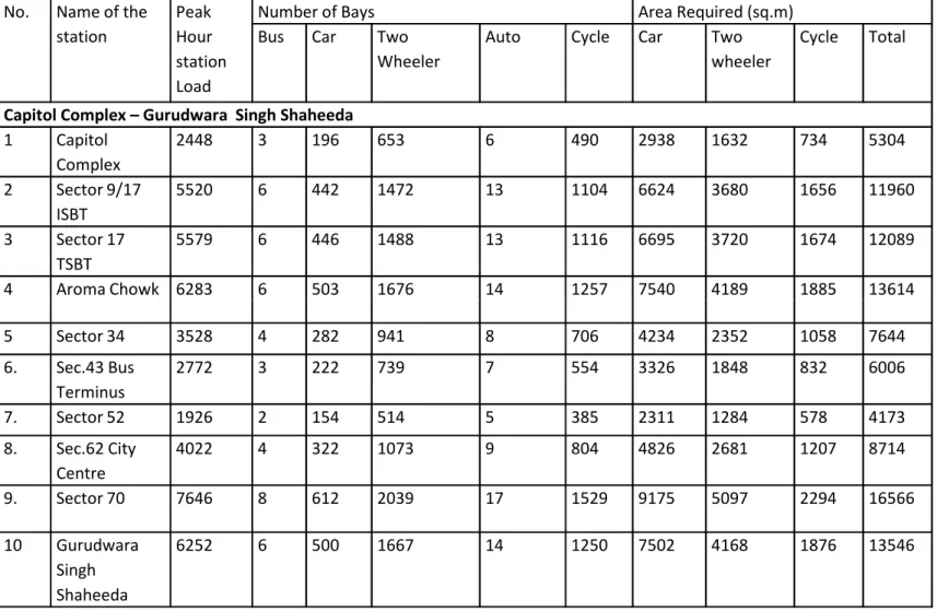
• This corridor will provide metro connectivity to the High Court, Secretariat, institutional buildings along Jan Marg including the Chandigarh UT Secretariat , Punjab Mini Secretariat, etc along Jan Marg ,tourism places such as Rock Garden and Rose Garden, City Centre Sector 17, Interstate Bus Terminus of Sector 17 and Sector 43, Sectors 9, 21, 22, 34, 35, 43, 44, 51, 52 of Chandigarh and Sectors 61, 62, 68, 69 & 70 of Mohali.
• The corridor will intersect with the EW Corridor at Matka Chowk Sector 9 enabling connectivity with Mullanpur in Punjab and Panchkula in Haryana.
• Integration of the corridor with the bus system will be through the bus terminus at sectors 17 and 43.
• Total 10 stations have been proposed on this corridor; out of these stations 6 stations are underground and remaining 4 are elevated. The entire length of this corridor in the Mohali area is proposed to be elevated.
• Future extension of the corridor to Aero City in Mohali is also being examined .
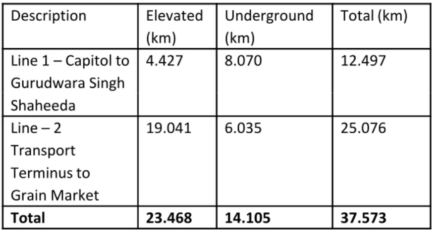
Description Elevated (km) Underground(km) Total (km) Line 1 – Capitol to Gurudwara Singh Shaheeda 4.427 8.070 12.497
TABLE 2 - Route length (end to end of station)
Detailed project report for the first phase of the Chandigarh
metro rail network by DMRC : North South Corridor - Capitol Complex to Gurudwara SinghShaheeda, Mohali (Corridor 1)
The projected number of passengers to be carried by this line are 1.43 lakh, 2.05 lakh, 3.20 lakh and 4.67 lakh in the years 2016, 2021, 2031 and 2041 respectively.
• This corridor will provide metro connectivity to the High Court, Secretariat, institutional buildings along Jan Marg including the Chandigarh UT Secretariat , Punjab Mini Secretariat, etc along Jan Marg ,tourism places such as Rock Garden and Rose Garden, City Centre Sector 17, Interstate Bus Terminus of Sector 17 and Sector 43, Sectors 9, 21, 22, 34, 35, 43, 44, 51, 52 of Chandigarh and Sectors 61, 62, 68, 69 & 70 of Mohali.
• The corridor will intersect with the EW Corridor at Matka Chowk Sector 9 enabling connectivity with Mullanpur in Punjab and Panchkula in Haryana.
• Integration of the corridor with the bus system will be through the bus terminus at sectors 17 and 43.
• Total 10 stations have been proposed on this corridor; out of these stations 6 stations are underground and remaining 4 are elevated. The entire length of this corridor in the Mohali area is proposed to be elevated.
• Future extension of the corridor to Aero City in Mohali is also being examined .
Line 1 – Capitol to Gurudwara Singh Shaheeda Line – 2 Transport Terminus to Grain Market 19.041 6.035 25.076 Total 23.468 14.105 37.573
Description Elevated Underground
Line 1 – Capitol to Gurudwara
Singh Shaheeda 4 6
Line 2 – Transport Terminus
to Grain Market 15 5
Total 19 11
TABLE 3 - Number of stations
This will extend from Transport Terminal –Mullanpur I & II – Sarangpur – Khuda Lahora – PGI – General Hospital – Sector 9 – Sector 7 – Sector 26 – Timber Market – Chandigarh Railway station – Housing Board Chowk – MDC Panchkula – HUDA Office Complex – City Center – Bus Station (Panchkula) – District Center – Village Raili – Grain Market. The number of passengers to be carried by this line are 1.48 lakh, 2.10 lakh, 3.90 lakh and 6.58 lakh in the years 2016, 2021, 2031, 2041 respectively.
This corridor will provide metro connectivity to the proposed new residential cum commercial development in Mullanpur and Sarangpur Area Chandigarh.
The corridor integrates with other transport modes such as Panchkula Bus Terminus and Chandigarh Railway station to the sectors 14, 11, 12, 10, 16, 9, 18, 8, 7, 19, 26, 27, 28, Manimajra, Rajeev Vihar and Mauli Jagran Complex, Chandigarh.
This corridor provides metro connectivity to the Panjab University, Punjab Engineering College, PGI Hospital, City Museum, market complexes, Wholesale Fruit and Grain market and Timber Market, Sector 26.
This corridor is proposed as elevated in the area of Mullanpur, Sarangpur and Panchkula.
There are a total of 20 stations on this corridor out of which 5 are underground and the remaining 15 are elevated.
Year Name of Corridor
Chandigarh Punjab Haryana Total PHPDT
2018 Corridor I 114876 53309 168185 7007
Corridor II 118267 14645 40804 173716 6711
2021 Corridor I 134200 71000 205200 8128
Corridor II 143000 19500 48300 210800 8597
2031 Corridor I 210300 110100 320400 12280
TABLE T4 : Forecast of METRO ridership by DMRC
East West Corridor - Transport Terminus Mullanpur to Grain
Market, Panchkula (Corridor 2)
This will extend from Transport Terminal –Mullanpur I & II – Sarangpur – Khuda Lahora – PGI – General Hospital – Sector 9 – Sector 7 – Sector 26 – Timber Market – Chandigarh Railway station – Housing Board Chowk – MDC Panchkula – HUDA Office Complex – City Center – Bus Station (Panchkula) – District Center – Village Raili – Grain Market. The number of passengers to be carried by this line are 1.48 lakh, 2.10 lakh, 3.90 lakh and 6.58 lakh in the years 2016, 2021, 2031, 2041 respectively.
This corridor will provide metro connectivity to the proposed new residential cum commercial development in Mullanpur and Sarangpur Area Chandigarh.
The corridor integrates with other transport modes such as Panchkula Bus Terminus and Chandigarh Railway station to the sectors 14, 11, 12, 10, 16, 9, 18, 8, 7, 19, 26, 27, 28, Manimajra, Rajeev Vihar and Mauli Jagran Complex, Chandigarh.
This corridor provides metro connectivity to the Panjab University, Punjab Engineering College, PGI Hospital, City Museum, market complexes, Wholesale Fruit and Grain market and Timber Market, Sector 26.
This corridor is proposed as elevated in the area of Mullanpur, Sarangpur and Panchkula.
There are a total of 20 stations on this corridor out of which 5 are underground and the remaining 15 are elevated.
Corridor II 268600 28900 92800 390300 22349
2041 Corridor I 3030000 164800 467800 17383
Corridor II 462400 34900 161000 658300 35637
Construction of Metro will meet the requirements of Metro Act
PLAN 10 - FIRST PHASE OF METRO PROPOSED BY DMRC FOR METRO AND BRTS CORRIDORS PROPOSED BY RITES WITHIN CHANDIGARH