PERFORMANCE OF REAL-TIME NETWORK
CODE DGPS SERVICES OF ASG-EUPOS
IN NORTH-EASTERN POLAND
Paweł Przestrzelski1, Mieczysław Bakuła1,21Department of Satellite Geodesy and Navigation University of Warmia and Mazury in Olsztyn
2Department of Air Navigation Polish Air Force Academy in Dęblin
Received 11 June 2013, accepted 5 June 2014, available on line 10 June 2014
K e y w o r d s: pseudorange, differential positioning, network corrections, GPS, ASG-EUPOS.
A b s t r a c t
This paper presents the performance study results of two ASG-EUPOS system services (KODGIS and NAWGIS) carrying out real-time network code DGPS positioning. In this elaboration, basic information about the system and discussed services are presented, as well as the advantages of the code differential positioning. The accuracies of the KODGIS and NAWGIS given by the system administrator are provided and papers and presentations with local and international impact were considered. A description of the experiment and the obtained results were provided for three days of measurements taken in north-eastern Poland, near Olsztyn. The research results showed that the positioning errors achieved using the KODGIS service throughout the study exceeded values declared by the ASG-EUPOS system administrator. This service, with respect to NAWGIS, was also characterized by higher fluctuations in the determined coordinates. Moreover, the occurrence of systematic errors in the performance of both studied services was noted, whereas the weakest element of the entire ASG-EUPOS system appeared to be the data transmission to the user.
Introduction
ASG-EUPOS is one among many of the regional augmentation GBAS systems (Ground Based Augmentation System) operating in Europe and beyond. Its establishment was a significant step forward in the context of the research on satellite navigation systems, as well as their practical applications. ASG-EUPOS was launched in 2008 and its administrator is the state institu-tion GUGiK (Head Office of Geodesy and Cartography). Initially, the system
Correspondence: Paweł Przestrzelski, Katedra Geodezji Satelitarnej i Nawigacji, Uniwersytet Warmińsko-Mazurski, ul. Heweliusza 5, 10-724 Olsztyn, e-mail: [email protected]
consisted of 98 continuously operating reference stations (CORS) evenly distributed within the territory of Poland (BOSYet al. 2008). Most of them only provided measurements from the American Global Positioning System (GPS). Over time, the ASG-EUPOS system has undergone constant updates and upgrades and now consists of 101 CORS stations, of which 31 are GNSS (Global Navigation Satellite Systems) stations (as of February 5, 2014). This system, since its establishment, has offered the following services to users:
– post-processing services – POZGEO (automatic data elaboration) and POZGEO-D (raw observational data);
– real-time services – NAWGEO, KODGIS and NAWGIS; – technical support service.
At the moment, new modules extending the functionality of the ASG--EUPOS systems are being prepared – ASG+ project (FIGURSKI et al. 2011).
The next CORS stations are being modified, enlarging the system’s functional-ity by additional satellite navigation systems. The daily number of loggings to individual services might serve as proof of the growing popularity of the ASG-EUPOS system (ORUBAet al. 2009). The most popular services primarily use phase observations (NAWGEO, POZGEO and POZGEO-D services). Apart from applications in everyday geodesic work (e.g. engineering surveying or cadastral surveying), services providing the highest accuracy are also being used in various research studies, including geodynamic studies (BOGUSZet al. 2012), atmospheric influence on GNSS measurements (WIELGOSZet al. 2011), precise satellite levelling (STĘPNIAKet al. 2013), control network establishment
(BAKUŁA 2013), positioning in hard observational conditions (BAKUŁA et al. 2012) and hydroacoustic measurements (POPIELARCZYK, TEMPLIN2013). The
situation appears quite different regarding the use of the KODGIS and NAWGIS services, where both use code observations for position calculation. For the first two years of the ASG-EUPOS system’s operation, connections with the studied services constituted c.a. 0.8% of all connections (ORUBA2009). However, the reasons for such a situation were not indicated. There is also a lack of KODGIS/NAWGIS studies, especially for their performance. One of the very few papers was prepared by WIŚNIEWSKI et al. (2013). Its authors
presented the results of real-time measurements conducted using a Garmin eTREX H GPS receiver and RTKLib software. The obtained results were considered insufficient. The accuracy of the NAWGIS service appeared to be on the level of the single point positioning mode, while the KODGIS service was characterized by only a slightly higher accuracy.
The purpose of this article is to study the performance of two ASG-EUPOS system services (KODGIS and NAWGIS) carrying out real-time network code DGPS positioning.
Network Code DGPS Positioning and KODGIS/NAWGIS Services
The DGPS positioning (Differential GPS) issue was brought up by many scientists worldwide (SAWAGUCHIet al. 2003, SPECHT2011, ZHANG, BARTONE
2005). This technique has successfully found application in navigation, Geo-graphical Information Systems and Location Based Services, etc. It is a rela-tively simple application, with low device and infrastructure costs and is a method which meets high performance requirements for integrity, continu-ity, availability and the accuracy of coordinate determination. Differential positioning in its classical approach (using a single reference station) elimi-nates systematic errors associated with satellites (HOFMANN-WELLENHOFet al.
2008). Some errors are correlated over a certain area and they are called distance-dependent errors, i.e. ionosphere and troposhpere refraction. The differential technique helps to eliminate this group of errors (SEEBER 2003).
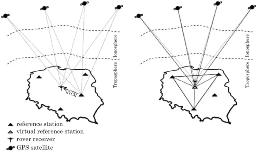
Systematic errors associated with distance decorrelation can be eliminated by applying the network solution (using at least three reference stations) for pseudorange correction (PRC) determination (BAKUŁA 2006). Figure 1 pres-ents schematic comparison of the classical and network approach. Virtual reference station (VRS) (Fig. 1) is a station created in the user vicinity using network of stations in order to reduce distance dependent errors. Some errors (i.e. multipath and receiver noise) are uncorrelated at the reference and user
receiver and cannot be corrected using DGPS. In fact, a user inherits the errors incurred at the reference station. Therefore, it is important to minimize these errors by careful siting and equipment selection at both the reference and user stations (MISRA, ENGE 2006). The effect of multipath and receiver noise on
code differential positioning was discussed extensively by SHUXINet al. (2002). The network code DGPS positioning method is carried out by the ASG--EUPOS system with KODGIS and NAWGIS services. This GBAS system transmits, for GPS observations, similar messages with the same intervals (given in brackets), i.e. 1(1 s), 3(6 s), and 59(9 s), of the RTCM standard (Radio Technical Commission for Maritime Services) in versions 2.1 and 2.3 for the NAWGIS and KODGIS services, respectively. However, there is one significant difference in the method of a PRC correction determination using a network of stations. PRC corrections in the KODGIS service are calculated directly for a user’s location (with the user’s approximate position sent to the ASG--EUPOS). This requires a two-way communication link. Although in the case of the NAWGIS service, PRC corrections are determined for two strictly-defined points, the geometric centers of the station network are for northern and southern Poland (ORUBA2013). That is why the user has the two data
streams to choose (NAWGIS-Polnoc and NAWGIS-Poludnie), depending on whether the user is located in the north (i.e. północ in Polish) or in the south (i.e. południe in Polish) of Poland. According to information broadcast on 25th
July 2013 through the ASG-EUPOS system included in the message number 3 of the RTCM 2.1 data stream for the two streams of the NAWGIS service, the coordinates of these virtual points are:
● for the NAWGIS–Polnoc stream:
– X= 3561343.30 m, – Y= 1331531.70 m, – Z= 5103877.65 m,
● for the NAWGIS–Poludnie stream:
– X= 3714504.63 m, – Y= 1425864.73 m, – Z= 4968518.98 m.
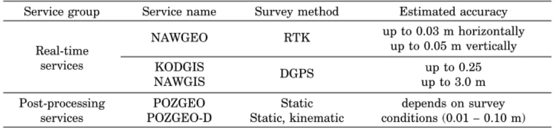
Currently (on 2nd July 2014) these coordinates differ from presented above. The administrator of the ASG-EUPOS system defined the achievable accuracy for individual services on the web page www.asgeupos.pl (Tab. 1). Unfortunately, there were no measures to describe those values. At the beginning of the full operational capability of the ASG-EUPOS system, BOSYet
al. (2008) presented the assumed accuracy of individual services. These values differ from the values given in Table 1 only for the KODGIS service. The authors assumed that its accuracy would range between 0.2 and 0.5 m. This value was repeated in a lecture given by ORUBA (2013). However, GRASZKA
(2012) stated that the error for the determined coordinates using KODGIS should not exceed 0.25 m horizontally and 0.5 m vertically. In the international literature, MONTEIRO et al. (2005) estimated that the DGPS error [95%] is
equal to 0.5 m to 1.0 m near the reference station. OHet al. (2005) reported an
increase in the accuracy of the code differential positioning of c.a. 40% using a station network and linear interpolation model for the PRC estimation. Taking into account these two aforementioned values leads to an achievable accuracy of 0.3–0.6 m in the case of PRC generated for the measurement site at the confidence level of 95%. This accuracy coincides with the values given for the KODGIS service by its administrator and the other authors mentioned in this paper. Other studies stated an accuracy of 0.1–0.3 m achieved with appropriately elaborated code observations and a network solution (BAKUŁA
2010). Other authors using various interpolation models significantly im-proved measurement accuracy in mountainous regions where height differen-ces exist between reference stations (NEJAT, KIAMEHR2013). It was shown that
in a short observation time, code network DGPS positioning results can produce even centimeter accuracy and can be more reliable than static relative phase positioning where gross errors often happen (BAKUŁA2007).
Table 1 Individual services and their achievable accuracy declared by the administrator
of the ASG-EUPOS system
Service group Service name Survey method Estimated accuracy up to 0.03 m horizontally up to 0.05 m vertically NAWGEO RTK KODGIS DGPS up to 0.25 NAWGIS up to 3.0 m Real-time services
Post-processing POZGEO Static depends on survey services POZGEO-D Static, kinematic conditions (0.01 – 0.10 m) Source: ASG-EUPOS, www.asgeupos.pl (access: 5.02.2014)
Experiment description
To study the performance of KODGIS and NAWGIS services of the ASG-EUPOS system, three days of static measurements were conducted using GPS observations. One measurement day consisted of two 90 minute sessions, one for each service. Measurements were performed simultaneously using two high-end TRIMBLE SPS882 receivers. The second device was used in order to detect possible irregularities in studies. Receivers were placed on an aluminum beam at a distance of 0.5 m and on equal heights. The calculated ellipsoidal
coordinates were automatically converted to Gauss-Kru¨ger conformal coordi-nates (X, Y) and, together with ellipsoid height (h), were recorded every 1 second. In the process of the coordinate calculations, all satellites located a minimum of 15 degrees above the horizon were involved. Phase and code observations were gathered simultaneously. The studies took place in north-eastern Poland, in the following cities (date in brackets): Morąg (25th July
2013), Frygnowo (27thJuly 2013) and Olsztyn (28thJuly 2013).The
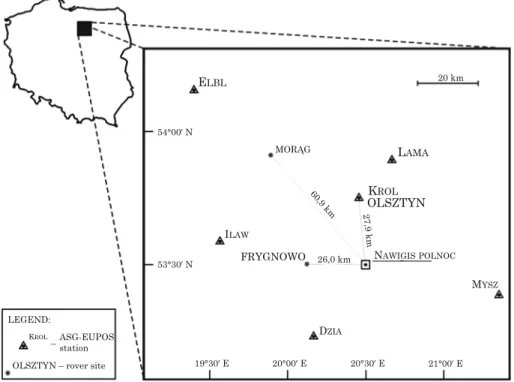
measure-ments were performed in an unobstructed area, whereas individual sessions were conducted at the same local time. The location of the measurement sites and distribution of the surrounding reference stations of the ASG-EUPOS system are presented in Figure 2. The two measurement sites shown in Figure 2 were located as far as possible at equal distances from the nearest reference stations of the ASG-EUPOS system. On average, this distance amounted to 41.8 km for the Morąg site (located in an urban area) and 34.5 km for the Frygnowo site (located in a rural area). Since the third measurement site was situated directly in Olsztyn, c.a. 140 m from the KROL station (an urban area), the KROL and Olsztyn captions converge in Figure 2.
The measurements were conducted between 9:00–10:30 a.m. (KODGIS service) and 12:30–2.00 p.m. (NAWGIS service) local time. The measurement break was caused by a low number (4) of observed satellites (Fig. 3b). A similar number of satellites, their even distribution (Fig. 3a) and negligible and weak disturbances of the ionosphere (Fig. 4) led to obtaining similar measurement conditions throughout the study. WANNINGER(1999) gave a detailed
descrip-tion of the I95 index presented in Figure 4.
Fig. 3. Satellites observed in Olsztyn: skyplots (a) and number of satellites (b)
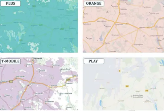
In order to establish a connection with ASG-EUPOS, the SIM cards of the two Polish internet providers were used: Plus and Orange. In Figure 5, coverage maps of the wireless internet in the HSDPA (High Speed Downlink Packet Access) technique were presented as declared by the four largest communication corporations operating in Poland (Plus, Orange, T-Mobile and Play). Reception delay of the correction data during lower solar activity conditions does not significantly influence accuracy performance of the code DGPS positioning (SCHLU¨TER et al. 2010). In the case of KODGIS and
NAWGIS services and their practical application in navigation more important seems to be continuity in receiving the data. Despite the assurance of the ORANGE company given on its website, no connection using any technique
Fig. 4. The ionospheric I95 index reflecting the condition of the ionosphere during the measurements Source: based on www.asgeupos.pl
involving a modem near Frygnowo was possible. One of the receivers was equipped with a SIM card of this internet provider. That is why discontinuity in measurements appeared, causing a break in measurements on the 26thJuly.
A change in the communication operator to the PLUS company allowed us to perform measurements the next day. Furthermore, when analyzing the maps all over the country delivered by the internet providers, white spots represen-ting a lack of internet connection are noticeable, as well as in the case of main communication routes (both water and land). This resulted in the lack of an internet connection and the consequent unavailability of the ASG-EUPOS data. Ensuring availability is one of performance requirements for using a given system in navigation.
Fig. 5. Coverage maps of the wireless HSDPA internet declared by the four largest communication corporations for the vicinity of Frygnowo. White spots represent a lack of coverage
Measurement results
The data gathered during the three-day study was later elaborated. For every session, a reference coordinate was first calculated (REF). This task was performed using raw observations (recorded simultaneously with calculated positions) and Topcon Tools v.8.2 software. Next, a standard deviation was calculated (σ) (which characterized the measurement precision) and, by using
reference coordinates, the value of the RMS error was obtained. The RMS error refers to the measurement accuracy. The following formulas were used:
σ =
√
Σ
n i=1(xi – x¯)2 , RMS =√
Σ
n i=1 (xi – xREF)2 (1) n– 1 n where:x¯ – mean value of the data set,
xREF – reference value,
xi – i-th element of the data set and n is a number of measurements. The final results obtained in the course of the study for two satellite receivers are summarized in Table 2. Apart from the accuracy (RMS) and precision (σ) of the measurement results and the maximum deviations (⏐dX⏐, ⏐dY⏐, ⏐dh⏐) from the reference value (REF), the average PDOP (Position
Dilution of Precision) coefficient was given, as well as the average number of satellites used in the position calculation process. These values reflect similar survey conditions that were present each day. The only difference appeared in the case of the measurement conducted using the NAWGIS service in Morąg. The average number of satellites used in the position calculation process was lower by approx. one (only 6.2 satellites). At the same time, both receivers recorded 7.2 satellites in the raw data on average. One satellite was rejected. This situation has automatically resulted in lower precision and accuracy, and in higher maximum deviations compared to the sessions conducted using the same service in Frygnowo and Olsztyn. This situation did not take place in the case of the remaining measuring sessions. Simultaneous measurement using two receivers (Table 2) demonstrated a lack of noticeable divergences in the obtained results and other problems, apart from the perturbation with the internet connection. All of this indicates the correctness of the performed study in terms of its technical aspects. Therefore, for reasons of clarity, only the results achieved with receiver number 1 will be further analyzed and presented graphically.
Comparing the results collated in Table 2 for the KODGIS and NAWGIS services, a higher accuracy of horizontal component determination (X– north component, and Y– east component) is noticeable for the latter. It is particu-larly visible for the measurement conducted in Frygnowo. In general, NAWGIS is characterized by a higher determination precision. However, in the case of measurements conducted in urban areas (Morąg and Olsztyn sites) height component (h) was determined with lower RMS error using the KODGIS service. The similar final results obtained with NAWGIS in Frygnowo and Olsztyn (26.0 and 27.9 km from the NAWGIS–Polnoc point,
Table 2 Tabulated results of KODGIS and NAWGIS positioning
σ Maximum RMS deviations Average X Y h ⏐dX⏐ ⏐dY⏐ ⏐dh⏐ PDOP # of sat. Measurement site Receiver # Service Name 0.16 1 0.24 0.12 0.15 0.29 0.32 0.98 0.66 3.27 2.4 7.3 KODGIS 0.16 0.26 0.09 0.14 0.47 0.60 0.90 0.32 1.75 3.6 6.2 Morąg NAWGIS 0.15 2 0.25 0.11 0.16 0.29 0.35 1.06 0.90 3.01 2.4 7.3 KODGIS 0.17 0.27 0.08 0.14 0.43 0.49 0.93 0.31 1.20 3.6 6.2 NAWGIS 0.33 1 0.40 0.25 0.39 0.83 0.83 2.60 1.63 5.32 2.5 7.1 KODGIS 0.12 0.13 0.06 0.08 0.16 0.36 0.67 0.20 0.84 2.4 7.2 NAWGIS Frygnowo 0.33 0.38 0.25 0.40 0.84 0.84 2.83 1.60 5.55 2.5 7.1 KODGIS 2 0.10 0.10 0.05 0.06 0.17 0.27 0.59 0.19 0.69 2.4 7.2 NAWGIS 0.13 0.19 0.06 0.21 0.23 0.23 0.61 0.42 0.88 2.5 7.0 KODGIS 1 0.09 0.12 0.06 0.06 0.19 0.32 0.36 0.15 0.83 2.4 7.2 Olsztyn NAWGIS 0.15 0.20 0.07 0.21 0.20 0.21 0.71 0.48 0.94 2.5 7.0 KODGIS 2 0.11 0.12 0.07 0.07 0.17 0.24 0.47 0.18 0.80 2.4 7.2 NAWGIS
respectively) and slightly worse results for the Morąg site (60.9 km from the NAWGIS–Polnoc point) confirmed the distance dependency from the reference station (in this case, the distance from the virtual point). On the other hand, despite a similar average distance to the nearest reference station for the Morąg and Frygnowo sites, a varying degree of accuracy was achieved. The distribution of horizontal components is presented in Figure 6. The coordinate determination error of horizontal components did not exceed 3 meters in either the KODGIS or NAWGIS services (Fig. 6a). In the case of KODGIS, the achieved results are not satisfactory because they do not meet the declared accuracy of 0.25 m (Table 1). Moreover, BOSYet al. (2008) described less strict
critical values of 0.2–0.5 m and, even then, the results presented for the KODGIS service do not meet these requirements. The error of coordinate determination exceeded 0.25 m, and often even 0.5 m (Fig. 6b). Much worse results were obtained for the height component, where the maximal deviations exceeded 5 m. Using the NAWGIS service, the position error did not exceed the declared 3.0 m, for either the horizontal components or the height component.
Fig. 6. Scatter plots of the obtained results. Full ( a ) and narrowed scopes ( b ) dimensions of the squares: outer – 1.0 x 1.0 m, inner – 0.5 x 0.5 m
Fig. 8. Histograms of the measurement errors obtained in Olsztyn: a – KODGIS, b – NAWGIS
Taking into account the results presented in Table 2 for the NAWGIS service, the fact that from the NAWGIS–Polnoc point to the most distant western border of Poland is less than 500 km, and also that the coordinate determina-tion error increases 0.2 m per 100 km from the reference stadetermina-tion (MONTEIROet
al. 2005), the accuracy at the borders should theoretically not exceed the values declared by GUGiK. Analyzing the position estimation in the time domain (Fig. 7) fluctuations can be noted in the determined coordinates. This phenom-enon concerns mainly the height component in the KODGIS service. It is also worth noting that the NAWGIS service was characterized by higher stability in determining the coordinates in the time domain. In Figure 7, higher deviations than 3 m were not taken into account. Nevertheless, such a situation took place many times in the case of estimating the height component using the KODGIS service in Frygnowo.
Employment of the network corrections in the differential code positioning should allow for the elimination of systematic errors from the measurement result (BAKUŁA2010). Meanwhile, coordinates determined using the KODGIS and NAWGIS services, which perform the network code positioning task, are not deprived of this group of errors. The shifts of the measurement results with regard to the reference coordinates indicating the existence of systematic errors are shown in Figure 8. The KODGIS service, as well as NAWGIS, are dedicated to applications in navigation and GIS systems. In both cases, the existence of systematic errors is not desirable.
Conclusions
This paper presents the performance study results of the two real-time services KODGIS and NAWGIS of the ASG-EUPOS system. Both services perform the network code DGPS positioning. The main conclusions are as follows:
1) The accuracy of the KODGIS service differs from the value given by the administrator of the ASG-EUPOS system. The position estimation error repeatedly exceeded the declared 0.25 m, particularly in the case of determin-ing the height component. For the NAWGIS service, in contrast, the position estimation error did not exceed the declared 3.0 m throughout the study.
2) Systematic errors were noted in the performance of both services. 3) The NAWGIS service exhibited a lower fluctuations than KODGIS in determining the coordinates.
4) The weakest component of the ASG-EUPOS system turned out to be data transmission to the user, which disrupted the continuity of measure-ments.
Exact determination of the positioning accuracy and other performance parameters of the KODGIS and NAWGIS services requires much more measurements conducted in various environmental conditions. However, the presented study performed in north-eastern Poland shows that application possibilities of the both services seems to be limited. It is mainly caused due to the presence of systematic errors and discontinuities in the data reception caused by telecommunication infrastructure.
Acknowledgements
The first author is a beneficiary of the project ,Scholarships for PhD students of Podlaskie Voivodeship’. The project is co-financed by European Social Fund, Polish Government and Podlaskie Voivodeship.
References
BAKUŁAM. 2013.Study of Reliable Rapid and Ultrarapid Static GNSS Surveying for Determination of the Coordinates of Control Points in Obstructed Conditions.Journal of Surveying Engineering, 139(4): 188–193.
BAKUŁAM., PELC-MIECZKOWSKAR., WALAWSKIM. 2012.Reliable and Redundant RTK Positioning for Applications in Hard Observational Conditions. Artificial Satellites, Journal of Planetary Geodesy, 47(1): 23–33.
BAKUŁAM. 2010.Network Code DGPS Positionig and Reliable Estimation of Position Accuracy.
Survey Review, 42(315): 82–91.
BAKUŁAM. 2007.Static Network Code DGPS Positioning vs. Carrier Phase Single Baseline Solutions for Short Observation Time and Medium-Long Distances.Artificial Satellites, Journal of Plane-tary Geodesy, 42(1): 167–183.
BAKUŁAM. 2006.An Approach of Network Code Differential GPS Positioning for Medium and Long Distances.Artificial Satellites, Journal of Planetary Geodesy, 41(4): 137–148.
BOGUSZJ., FIGURSKIM., KONTNYB., GRZEMPOWSKIP. 2012.Horizontal velocity field derived from EPN and ASG-EUPOS satellite data on the example of south-western part of Poland.Acta Geodynamica et Geomaterialia, 9(3): 349–357.
BOSYJ., ORUBAA., GRASZKAW., LEONCZYKM., RYCZYWOLSKIM. 2008.ASG-EUPOS densification of EUREF permanent network on territory of Poland.Reports on Geodesy, 2(85): 105–112. FIGURSKIM., BOSYJ., KONTNYB., WIELGOSZP. 2011.ASG+: project for improving Polish
multifunc-tional precise satellite positioning system.Reports on Geodesy, 2(91): 51–58.
GRASZKAW. 2012.ASG-EUPOS. Current status of the system.Conference: On modern problems of fundamental geodetic networks, 18–19 October 2012, Grybów (presentation in polish). HOFFMAN-WELLENHOFB., LICHTENEGGERH., WASELE. 2008.GNSS – GPS, GLONASS, Galileo and
more.Springer–Wien–NewYork.
MISRAP., ENGEP. 2006.Global Positioning System: Signals, Measurements, and Performance.2nd edition, Ganga-Jamuna Press.
MONTEIROL.S., MOORET., HILLCH. 2005.What is the accuracy of DGPS?Journal of Navigation, 58(2):
207–225.
NEJAT D., KIAMEHR R. 2013.An investigation on accuracy of DGPS network-based positioning in mountainous regions, a case study in Alborz network.Acta Geodaetica et Geophysica, 48(1): 39–51. OH K.R., KIM J.C., NAM G.W. 2005. Development of Navigation Algorithm to Improve Position
Accuracy by Using Multi-DGPS Reference Stations’ PRC Information.Journal of Global Position-ing Systems, 4(1–2): 144–150.
ORUBA A. 2013. Differential GNSS measurements and real time services: NAWGEO, KODGIS, NAWGIS.Training for the ASG-EUPOS users, 10–11 October 2013, Olsztyn (presentation in polish).
ORUBAA., GRASZKAW., RYCZYWOLSKIM., WAJDASZ. 2009.The ASG-EUPOS – Current Status and Development Plans.Reports on Geodesy, 1(86): 13–30.
POPIELARCZYKD., TEMPLINT. 2013.Application of Integrated GNSS/Hydroacoustic Measurements and GIS Geodatabase Models for Bottom Analysis of Lake Hancza: the Deepest Inland Reservoir in Poland.Pure and Applied Geophysics, DOI: 10.1007/s00024-013-0683-9.
SAWAGUCHI I., NISHIDA K., SHISHIUCHIM., TATSUKAWA S. 2003.Positionig precision and sampling number of DGPS under forest canopies.Journal of Forest Research, 8(2): 133–137.
SCHLU¨TERS., MINKWITZD., HIRRLEA. 2010.Investigations of decorrelation effects on the performance of DGNSS systems in the Baltic Sea.5th ESA Workshop on Satellite Navigation Technologies and European Workshop on GNSS Signals and Signal Processing (NAVITEC), 8–10 December, 736–742.
SEEBERG. 2003.Satellite geodesy: foundations, methods and applications, Walter de Gruyter. SHUXIN CH., YONGSHENGW., FEI CH. 2002. A study of differential GPS positioning accuracy.3rd
International Conference on Microwave and Milimeter Wave Technology, ICMMT, 17–19 August, pp. 361–364.
SPECHTC. 2011.Accuracy and coverage of the modernized Polish Maritime differential GPS system.
Advances in Space Research, 47(2): 221–228.
STĘPNIAKK., BARYŁAR., WIELGOSZP., KURPIŃSKIG. 2013.Optimal Data Processing Strategy In Precise GPS Levelling Networks.Acta Geodeynamica at Geomaterialia, 10(4): 443–452.
WANNINGERL. 1999.The Performance of Virtual Reference Stations in Active Geodetic GPS-Networks under Solar Maximum Conditions.Proceedings of ION 99, Nashville TN: 1419–1427.
WIELGOSZ P., CELLMER S., RZEPECKA Z., PAZIEWSKI J., GREJNER-BRZEZIŃSKA D. 2011. Troposphere modeling for precise GPS rapid static positioning in mountainous areas.Measurement Science and Technology, 22(4): 1–8.
WIŚNIEWSKIB., BRUNIECKIK., MOSZYŃSKIM. 2013.Evaluation of RTKLIB’s Positioning Accuracy Using low-cost GNSS Receiver and ASG-EUPOS. TransNav – the International Journal on Marine Navigation and Safety of Sea Transportation, 5(1): 79–85.
ZHANY., BARTONECH.G. 2005.A real-time meteorological-based troposphere (RTM) correction with integrity bound for long baseline DGPS.GPS Solutions, 9(4): 255–272.