ARCJHIAJEOILOG][CAIL RJECONNA][§§ANCJE OIF 'Il'lHilE
MlUILILlE'Il' lHIAILIL 'Il'RAC'Il', JOJHIN§ ][§JLAN][)),
ClHIARlLlE§'Il'ON COlUN'Il'Y, §OlU'Il'lHI CAROJL][NA
© 2001 by Chicora Foundation, Inc. All rights reserved. No part of this publication may be reproduced, stored in a retrieval system, transmitted, or transcribed in any form or by any means, electronic, mechanical, photocopying, recording, or otherWise without prior permission of Chicora Foundation, Inc. except for brief quotations used in reviews. Full credit must be given to the authors, publisher, and project sponsor.
ARCHAEOLOGICAL RECONNAISSANCE OF THE
MULLET HALL TRACT, JOHNS ISLAND,
CHARLESTON COUNTY, SOUTH CAROLINA
Prepared by: Natalie Adams Michael Trinkley
Prepared for: Mr. Ray Pantlik Kiawab Resort Associates
Beachwalker Drive
Kiawab Island, South Carolina 29455
Chicora Research Contribution 153
Chicora Foundation, Inc. P.O. Box 8664 a 861 Arbutus Dr.
Columbia, South Carolina 29202 803/787-6910
September 19, 1994
AlB§'fRAC'f
This reconnaissance level study was undertaken by Chicora Foundation to evaluate the archaeological potential of the Mullet Hall Plantation tract for Kiawah Resort Associates. The investigations have concentrated on suspected historic sites, including main plantation complexes, slave settlements, and cemeteries, although some attention has also been given to potential Native American sites.
One previously recorded archaeological site (38CH487) was revisited and 11 new archaeological sites (38CH1539 - 38CHl549) were recorded (including three cemeteries. While a reconnaissance level investigation is not typically intended to provide National Register eligibility assessments, it is possible to offer tentative professional opinions regarding potential site significance. Readers should be aware that these recommendations are based on limited field investigations and may change as additional research is conducted. They do, however, offer an initial assessment to help guide long-range planning in a cost-effective manner.
Two of the identified sites (38CHl548 and 38CH1549) are cemeteries. No above-ground evidence for a third reputed cemetery could be found during these studies. One cemetery (38CHl548) is relatively well defined by the surrounding agricultural field. The other cemetery (38CH1549) has been extensively damaged by the current property owner and requires considerable attention (recovering and restoring markers, and delimiting the cemetery boundaries). These sites are not only potentially eligible for the forensic anthropological information they contain, but are also protected by South Carolina State Law. The third cemetery likely exists, but will require extensive archaeological investigations to identify any reasonable boundaries and, at this time, has not been recorded.
Three of the identified sites (38CH1539, 38CH1544, and 38CHl546) are recommended as likely not eligible for inclusion on the National Register of Historic Places. At least one (38CH1539) represents materials redeposited from elsewhere (probably downtown Charleston), while the others are either very small or represent tenant sites with very limited data sets.
Seven of the identified archaeological sites (38CH487, 38CH1540, 38CHl541, 38CHl542, 38CHl543, 38CH1545, and 38CHl547) are likely eligible or potentially eligible for inclusion on the National Register of Historic Places. These represent the remains of three distinct plantation settlements, including main complexes and slave rows, situation on what is today Mullet Hall. In general boundaries for each site have been identified. A general "feeling" for the types of data sets present and the nature of the research questions each site could address has been obtained. In several cases it is likely that more intensive field investigations will be necessary to either determine eligible or to develop a data recovery plan.
The potential for Native American sites is relatively high in a few areas of the plantation, especially along the wetland creeks on the southern third of the plantation. In general, however, these sites have been extensively damaged by either plowing or dredging operations. It is unlikely that potentially significant Native American sites will be encountered on the plantation.
'TI'Alln:.JE OF CON'TI'JEN'TI'S
List of Figures List of Tables Introduction
Effective Environment
Physiography and Geology Climate
Floris tics
Prehistoric and Historic Synopsis Previous Research Prehistoric Synopsis
Paleoindian and Archaic Periods Early Woodland
Middle Woodland
Late Woodland and South Appalachian Mississippian Protohistoric
Brief History of the Mullet Hall Tract Field Methods
Sites Identified
Previously Identified Archaeological Sites New Sites 38CH1539 38CHl540 38CH1541 38CH1542 38CH1543 38CH1544 38CH1545 38CH1546 38CH1547 38CH1548 38CH1549 Conclusions
Eligible or Potentially Eligible Sites Sites Which Are Likely Not Eligible Cemeteries
Future Survey Work Sources Cited ii iii iii 5 IO 24 27 34 38
LIST OF FIGURES
Figure .
1. Vicinity of the project area
2. Project area showing identified sites
3. Thornton-Morden map of 1695 showing the project area 4. Woodland Period phases
5. Mills' Atlas of 1825 showing the project area 6. 1854 Coastal Survey map showing area plantations 7. 1863 Map of Charleston
8. 1929 Sanitary Commission map of the project area 9. J.T. Killock Property Map
10. 1942 General Highway and Transportation Map 11. Plowed fields on the Mullet Hall tract
12. Site 38CH1539
13. 38CH1540, showing the four areas identified in the survey
LIST OF TABLES
Table
1. Summary of identified sites
iii 2 3 11 13 19 20 21 22 23 23 25 25 29 34
llN'll'JR 0 ][)UC 'll'll 0 N
Chicora Foundation was requested by Mr. Ray Pantlik of Kiawah Resort Associates (KRA) to submit a budgetary proposal for an archaeological reconnaissance level survey of the Mullet Hall tract containing
approximately 1020 acres. Specifically, the study was to address:
a the potential for the existence of cultural resources in the project area,
a the nature of disturbances in the area and the likelihood that they might may have affected any identified cultural resources, and
a the potential eligibility of any identified cultural resources on the tract (within the scope and ability of a reconnaissance investigation).
Chicora Foundation provided a budgetary proposal and a brief outline of the tasks involved in a reconnaissance level study during a meeting on August 22, 1994. The proposed work would consist of :
a a review of the S.C. Institute of Archaeology and Anthropology site files;
a coordination with the S.C. State Historic Preservation Office for any National Register sites or previous architectural surveys in the immediate area;
a a professional assessment addressing the likelihood of identifying archaeological or historical sites in the project area, based on a review of previously identified sites, a review of pertinent nineteenth and twentieth century canographic sources, and our professional experience in the project area; and
a five field days to examine areas with good surface visibility (e.g. road cuts and plowed fields) as well as areas with high archaeological probability, such as dry ridges adjacent to the marsh.
Kiawah Resort Associates accepted this proposal on August 24, 1994. Ms. Natalie Adams examined the site files of the S.C. Institute of Archaeology and Anthropology. Dr. Michael Trinkley conducted background historical research at the South Carolina Historical Society and the Charleston County Register of Mesne Conveyances on August 25 and 26, 1994. A project area map was faxed to the S.C. Historic Preservation Office requesting information on National Register sites and previous architectural surveys. A verbal response from Dr. Tracy Powers indicated that there were no previously recorded architectural sites or National Register sites on the project tract.
It is important to emphasize that since this study incorporated only a reconnaissance level investigation of the Mullet Hall tract, no intensive investigations of either the historical or archaeological resources were undertaken. The preliminary historical survey only briefly explored the available sources. Field investigations at individual sites was limited and no comprehensive sub-surface investigations were undertaken. Nor were the cemeteries identified on the tract thoroughly recorded.
The field investigations were undertaken by Ms. Natalie Adams and Mr. Ryan Boera on September 5
through September 9, 1994. The laboratory processing of the resulting collections, curation preparations, and
2
_..:.
"'
~
~
.D u:a
~
Q<
"'
Cl"'
;:::>]
.!!Ij
~
~
"
~ OJ).3
.g
"'
@
£
·i;;"'
-~ OJ)8
j
a~
""
E-<§
~~
g
8
~g
a"'
~"[
~
u
.£l
"'
'<; a § ·.c 1l3
,..,;j
' ,_ 3report production have taken place at Chicora Foundation's laboratories in Coltunbia from September 12 through September 16, 1994.
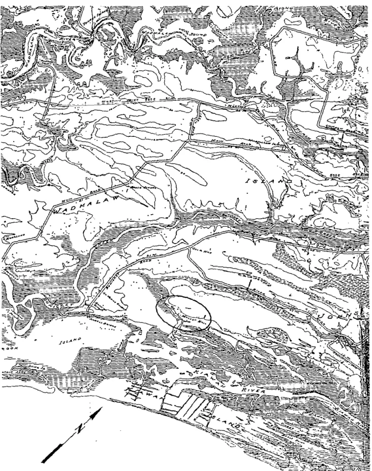
The approximately 1020 acre Mullet Hall tract is situated on John's Island in Charleston County (Figure 1). It is bounded to the south by the marshes of the Kiawah River, to the east by a portion of Bryan's Creek and private property, and to the north and west by private property (Figure 2). Portions of the northern and eastern boundaries were previously part of Mullet Hall, and represent a tract of about 734 acres which was recently sold to the Charleston County Parks and Recreation Commission (Charleston County T.M.S. 212-0-0).
The property is roughly bisected into east and west halves by Mullet Hall Road (S-8-2146). Most of the well drained soils (approximately 400 acres) are in cultivated or fallow fields, providing excellent visibility in these areas. There is an extensive network of farm roads allowing good access to most of these well drained areas.
The study was also facilitated by the generosity of both Betty Stringfellow, a local historian who shared with us her collection of inforntation on Mullet Hall, and W.L. Limehouse, who has farmed the tract for a ntunber of years. Both provided significant infortnation on land use, historic resources, and potential sources for additional inforntation should KRA exercise its option and purchase the tract.
lEJFJF'lEC1'IVlE lENVIRONMlEN1'
Physiology and Geology
Charleston County is situated in the central lower coastal plain of South Carolina and is bounded on the east by about 75 miles of irregular Atlantic Ocean shoreline and marsh, barrier, and sea islands. The mainland topography consists of subtle undulations in the landscape characteristic of ridge and bay topography of beach ridge plains. Elevations in the county range from sea level to about 70 feet mean sea level (MSL) (Mathews et al. 1980: 133).
Seven major drainages are found in Charleston County. Four of these, the Wando, Ashley, Stono, and North Edisto, are dominated by tidal flows and are saline. The three with significant freshwater flow are the
Santee, forming the northern boundary of the County, the South Edisto, forming the southern boundary, and the Cooper, which bisects the County. The distinctions between these rivers were of particular significance to the area planters since the fresh water rivers became areas of extensive tidal rice cultivation. Rice cultivation was tried on the more saline rivers, but with limited success. The Wando River rice planters, for example, found early in the nineteenth century that they could not complete with the more favorable resources of rice planters on the Santee or Edisto.
Because of the low topography, many broad, low-gradient interior drains are present as either extensions of the tidal rivers or as flooded bays and swales. These are often seen as small creeks or even as low, poorly drained interior areas. This feature is also known to have been of considerable importance to the area planters. While these low soils were frequently fertile, they had to be drained. Not only did this require constant attention, but it was realized to be unhealthy work.
The geology of the county is characteristic of the coastal plain, with unconsolidated, water-laid beds of sands and clays up to 20 feet in thickness overlying thick beds of soft marl (Miller 1971). The high ground of the Mullet Hall tract is characterized by five soil series: very poorly drained Capers silty clay loam; poorly to very poorly drained Dawhoo and Rutlege sands; somewhat poorly drained Kiawah loamy fine sand; moderately well drained Seabrook loamy fine sand; very poorly drained Stono sandy loam; and poorly drained Yonges loamy fine sand (Miller 197l:Maps 74, 75, 81, and 82). Of the approximately 1020 acres of highground, about 400 acres may be classified as well drained.
Coastal Plain geological formations are unconsolidated sedimentary deposits of very recent age
(Pleistocene and Holocene) lying unconformably on ancient crystalline rocks (Cooke 1936; Miller 1971:74). The Pleistocene sediments are organized into topographically distinct, but lithologically similar, geomorphic units, or terraces, parallel to the coast.
The Recent terrace ranges from about sea level to six feet above and occurs along the coast and for a few miles up major streams. Soils are primarily Capers series and Tidal marsh lands. The Pamlico terrace ranges from six to 25 feet above sea level. This terrace includes most of Charleston County. The Talbot terrace ranges from 25 to 42 feet and occurs southeast of Ladson, in parts of the western portion of the county, and along the Berkeley County line from southwest of Wambaw Creek almost to the Wando River (Miller 1971:74).
Another significant aspect of coastal geology to be considered in these discussions is the fluctuation of sea level during the late Pleistocene and Holocene epochs. Prior to 15,000 B.C. there is evidence that a warming
trend resulted in the gradual increase in Pleistocene sea levels (DePratter and Howard 1980). Work by Brooks et al (1989) clearly indicates that there were a number of fluctuations during the Holocene. Their data suggest that as the first Stallings phase sites along the South Carolina coast were occupied about 2100 B.C. the sea level was about 4.2 feet lower than present Following that period there was a gradual fall in the sea level to about 11.0 feet below current levels by 1850 B.C. Sea levels gradually increased during the Thom's Creek phase to a level within about 2.0 feet of the current stands by 1650 B.C. Following this was a second lowering about 1250 B.C., to a level of 9.7 feet below that of today. The sea level increased through the late Thom's Creek phase to a high about 2.8 feet below modem levels by 1050 B.C. Another low, about 9.7 feet, occurred at 350 B.C. after which the sea levels tend to maintain a gradual rise to their modem levels. Quitmyer (1985) does not believe that the lower sea levels at 2100 B.C. would have greatly altered the estuarine environment, although drops of nearly 10 feet would have reduced available tidal resources and would have affected the overall drainage patterns and soil moisture of coastal sites.
Data from the nineteenth and twentieth centuries suggest that the level is continuing to rise. Kurtz and Wagner (1957:8) report a 0.8 foot rise in Charleston, South Carolina sea levels from 1833 to 1903. Between 1940 and 1950 a sea level rise of 0.34 foot was again recorded at Charleston. These data, however, do not distinguish between sea level rise and land surface submergence.
Within the coastal zone the soils are Holocene and Pleistocene in age and were formed from materials that were deposited during the various stages of coastal submergence. The formation of soils in the study area is affected by this parent material (primarily sands and clays), the temperate climate (to be discussed later in this section), the various soil organisms, topography, and time.
The mainland soils are Pleistocene in age and tend to have more distinct horizon development and diversity than the younger soils of the sea and barrier islands. Sandy to loamy soils predominate in the level to gently sloping mainland areas. The island soils are less diverse and less well developed, frequently lacking a well-defined B horizon. Organic matter is low and the soils tend to be acidic. The Holocene deposits typical of barrier islands and found as a fringe on some sea islands, consist almost entirely of quartz sand which exhibits little organic matter. Tidal marsh soils are Holocene in age and consist of fme sands, clay, and organic matter deposited over older Pleistocene sands. The soils are frequently covered by up to 2 feet of saltwater during high tides. Historically, marsh soils have been used as compost or fertilizer for a variety of crops, including cotton (Hantmond 1884:510) and Allston mentions that the sandy soil of the coastal region, ''bears well the adnllxture of salt and marsh mud with the compost'' (Allston 1854: 13).
The survey tract is characterized by elevations ranging from about O to 15 feet MSL, with the bulk of the property at or below 10 feet MSL. There is a gradual slope toward the marshes of Bryan's and Mullet Hall Creeks. The property is roughly bisected by Mullet Hall Road (S-8-2146) into east and west halves. A number of dirt farm roads provide access to most of the well drained areas of the tract (which are under cultivation).
Climate
John Lawson described South Carolina, in 1700, as having "a sweet Air, moderate Climate, and fertile Soil" (Lefler 1967:86). Of course, Lawson tended to romanticize Carolina. In December 1740 Robert Pringle remarked that Charleston was having ''hard frosts & Snow" characterized as "a great Detriment to the Negroes" (Edgar 1972:282), while in May 1744 Pringle states, "the weather having already Come in very hot!" (Edgar 1972:685).
The major climatic controls of the area are latitude, elevation, distance from the ocean, and location with respect to the average tracks of migratory cyclones. Charleston County's latitude of places it on the edge of the balmy subtropical climate typical of Florida, further south. As a result, there are relatively short, mild winters and long, warm, humid summers. The large amount of nearby warm ocean water surface produces a marine climate, which tends to moderate both the cold and hot weather. The Appalachian Mountains, about 220 miles to
the northwest, block the shallow cold air masses from the northwest, moderating them before they reach the sea islands (Mathews et al 1980:46).
The average high temperature in the Charleston area in July is 89° F. Mills noted:
in the months of June, July, and August, 1752, the weather in Charleston was warmer than any of the inhabitants before had ever experienced. The mercury in the shade often rose above 90° ,
and for nearly twenty successive days varied between that and LOI 0
(Mills 1972 [1826]:444).
Charleston normally experiences a high relative humidity, adding greatly to the discomfort. Pringle remarked in 1742 that guns "sufferr'd with the Rust by Lying so Long here, & which affects any Kind of Iron Ware, much more in this Climate than in Europe" (Edgar 1972:465).
The annual rainfall in the Charleston area is 49 inches, fairly evenly spaced over the year. While adequate for most crops, there may be periods of both excessive rain and drought. Mills remarks that the "Summer of 1728 was uncommonly hot; the face of the earth was completely parched; the pools of standing water dried up, and the field reduced to the greatest distress" (Mills 1972 [1826]:447-448). Another significant historical drought occurred in 1845, affecting both the Low and Up Country.
The annual growing season for Charleston County is 295 days, one of the longest in South Carolina. Along the "sea shore" the close proximity to the water extended this growing season allowing parts of Christ Church to rival the Florida growing season. This mild climate, adequate rainfall, and long growing season was particularly useful during the late nineteenth and early twentieth cenmries when the area emphasized truck cropping.
Hilliard (1984) points out that "any description of climate in the South, however brief, would be incomplete without reference" to a meteorological event frequently identified with the region - the tropical hurricane. Hurricanes occur in the late summer and early fall, the period critical to antebellum cane, cotton, and rice growers. These storms, however, are capricious in occurrence:
in such a case between the dread of pestilence in the city, of common fever in the country, and of an unexpected hurricane on the island, the inhabitants ... are at the close of every warm season in a painful state of anxiety, not knowing what course to pursue, not what is best to be done (Ramsay, quoted in Calhoun 1983:2).
The coastal area is a moderately high risk zone for tropical storms, with 169 hurricanes being documented from 1686 to 1972 (0.50 per year) (Mathews et al. 1980:56).
The climate of the Charleston area, regardless of storms, temperature, humidity, or rainfall, was often viewed as harsh and unhealthful especially for the white population. Mills states:
the numerous swamps, bays, and low grounds which indent the low country, retain the waters that fall in rains; and in consequence of these, occasion thick fogs throughout the night, during the summer months. Under such circumstances it is a matter of little surprise that fevers prevail .... The two fevers most dreaded here, are, what are commonly termed the country and yellow fever. The first is peculiar to the country, and to avoid it, the planters are in the habit either of residing in Charleston during the sickly season, or retiring to the Sea Islands or Sand
hills. The second belongs exclusively to the city, and is generally fatal to strangers only, who have not, as it is termed, become climatized (Mills 1972 [1826]: 140-144).
Expounding on the evil of the swamps, Mills also explained:
that to the extensive swamps and stagnant pools, which cover its surface, are we to attribute the cause of our epidemical diseases. The rank luxuriance of vegetation on these waste lands, their perpetual moisture, and the operation of a powerful sun, produce at certain seasons of the year, in a degree indeed extensive, the rapid decomposition of this vegetable matter: the miasma arising from this decomposition contaminates the surrounding air, which afterwards is wafted by the winds over the country, and poisons, more or less, the whole atmosphere (Mills 1972 [1826]:462).
Floristics
The Charleston County area contains three major ecosystems: the maritime forest ecosystem which consists of the upland forest areas, the estuarine ecosystem of deep water tidal habitats, and the palustrine ecosystems which consist of essentially fresh water, non-tidal wetlands (Sandifer et al. 1980:7-9).
The maritime forest ecosystem has been found to consist of five principal forest types, including the Oalo-Pine forests, the Mixed Oak Hardwood forests, the Palmetto forests, the Oak thickets, and other miscellaneous wooded areas (such as salt marsh thickets and wax myrtle thickets).
In some areas of Oak-Pine forests palmetto becomes an important sub-dominant. Typically these forests are dominated by the laurel oak with pine (primarily loblolly with minor amounts of long\eaf pine) as the major canopy co-dominant Hickory is present, although uncommon. Other trees found are the sweet gum and
magnolia, with sassafras, red bay, American holly, and wax myrtle found in the understory.
In the Mixed Oak Hardwood forests pine is reduced in importance and the laurel oak is replaced by the live oak. Yaupon holly and red bay or magnolia are found in the understory. The Palmetto forests are
characterized by open palmetto stands with an understory of wax myrtle, red cedar, yaupon holly, and magnolia. The miscellaneous wooded areas include wax myrtle thickets found in low areas behind the dune fields.
Mills, in the early nineteenth century, remarked that
South Carolina is rich in native and exotic productions; the varieties of its soil, climate, and geological positions, afford plants of rare, valuable, and medicinal qualities; fruits of a luscious, refreshing, and nourishing nature; vines and shrubs of exquisite beauty, fragrance, and
luxuriance, and forest trees of noble growth, in great variety (Mills 1972 [1826]:66).
The loblolly pine was called the "pitch or Frankincense Pine" and was used to produce tar and turpentine; the long leaf pine was "much used in building and for all other domestic purposes;" trees such as the red bay and red cedar were often used in furniture making and cedar was a favorite for posts; and live oaks were recognized as yielding "the best of timber for ship building;" (Mills 1972 [1826]:66-85). Mills also observed that:
in funner years cypress was much used in building, but the difficulty of obtaining it now, compared with the pine, occasions little of it to be cut for sale, except in the shape of shingles; the cypress is a most valuable wood for durability and lightness. Besides the two names we have cedar, poplar, beech, oak, and locust, which are or may be also used in building (Mills
1972 [1826]:460).
The "Oak and hickory high lands" according to Mills were, "well suited for com and provisions, also for indigo and cotton" (Mills 1972 [1826]:443). The value of these lands in the mid-1820s was from $10 to $20 per acre, less expensive than the tidal swamp or inland swamp lands (where rice and, with drainage, cotton could be
grown).
tidal wetlands. Salinity may range from 0.5 ppt at the head of an estuary to 30 ppt where it comes in contact with the ocean. Estuarine systems are influenced by ocean tides, precipitation, fresh water runoff from the upland areas, evaporation, and wind. Estuarine systems are extremely important to our understanding of both prehistoric and historic occupations because they naturally contain a high biomass (Thompson 1972:9). The estuarine area contributes vascular flora used for basket making, as well as mammals, birds, fish (over 107 species), and shellfish.
While shellfish are only briefly itemized by Mills in the context of a food source, he elaborates in his discussion of building material, observing that:
lime is obtained from burning oyster shells. It makes a very good mortar, where good sharp sand is used, though it is not equal to the stone lime (Mills 1972 (1826):460).
While the primary historic use of shellfish may have been for the production of lime, the large numbers of shell middens in coastal area clearly indicate the importance of shellfish in the aboriginal diet (see Trinkley 1991:214-215).
The last environment to be briefly discussed is the freshwater palustrine ecosystem, which includes all wetland ecosystems, such as the swamps, bays, savannas, pocisins, and creeks, where the salinities measure less
than 0.5 ppt. These palustrine ecosystems tend to be diverse, although not well studied (Sandifer et al. 1980:295).
A number of forest types may be found in the palustrine areas which would attract a variety of terrestrial mammals. The typical vegetation might consist of red maple, swamp tupelo, sweet gum, red bay, cypress, and various hollies. Also found would be wading birds and reptiles. It seems likely that these freshwater environs were of particular importance to the prehistoric occupants.
lPRJElH!liSl'ORliC ANID lH!liSl'ORliC SYNOJPSliS
Previous Research
The only previous research performed on the Mullet Hall tract was in 1980 by Stanley South and Michael Hartley (South and Hartley 1980) during their search for seventeenth century plantation sites as a part of their seventeenth century settlement pattern study. They believed that the Mullet Hall tract contained Grice's Plantation which appears on the 1695 Thornton-Morden Map (Figure 3). One site (38CH487) was recorded during their investigations just east of Mullet Hall Road in which they found no evidence of seventeenth century occupation, but found instead mid- to late-nineteenth century remains. They also visited another area shown to
them by the landowner, Mr. W.L. Limehouse. This area (Area A of 38CH487) contained the ruins of a house. In
spite of its general topographic agreement with the Thornton-Morden map, South and Hartley did not believe that this site was Grice's Plantation.
Both of these sites were revisited during the current investigations. What had been previously identified as Area A of 38CH487 was, during this survey, recorded as a separate site (38CHl540) in order to make assessments and future archaeological research more convenient. This decision to separate the sites was made in consultation with Mr. Keith Derting, site files manager at the S.C. Institute of Archaeology and Anthropology.
Based on other Charleston County research (see, for example, Brooks and Scurry 1978, Scurry and Brooks 1980, and Trinkley 1993), few sites are found in the interior, away from marsh or freshwater habitats. Most sites, based on these previous studies, are found on excessively to well drained soils, although a few are consistently found in areas which are poorly drained (which suggests that factors other than drainage may occasionally have determined prehistoric settlement locations). Research in the Low Country also suggests that sites will most commonly be found on major sand ridge elevations overlooking the wetland habitats.
Work by South and Hartley (1980) suggests that major historic site complexes, at least during the seventeenth and eighteenth centuries, will be found on high ground adjacent to a deep water access. Plantation main houses tend to be located on the highest and best drained soils, while slave settlements may be found in intermediate or even poorly drained areas. Both settlement types, however, tend to be in close proximity to the rice fields or other agricultural work areas. Extractive or milling sites will be located near necessary raw materials and where the products can be easily transported in and out. Healthful conditions and drainage are not usually significant considerations, at least for slave settlements. Later in the nineteenth century, as holdings became smaller, settlements often were placed in less than "ideal" locations. Even on nearby Kiawab Island, the two (and later three) plantations shared one central landing, recognizing that it was impossible for all three to be situated on ''high ground" and "deep water." Later, especially in the late nineteenth century, tenant farm sites tend to be more closely associated with the improving road systems, gradually being dispersed over the plantation landscape.
Based on these previous studies and the presented data on the soils and drainage typical of the survey area, the Mullet Hall tract tends to have a high probability of prehistoric and historic archaeological remains. Prehistoric sites may be reasonably expected on the high sandy ridges overlooking the lower soils and marsh areas, although experience on nearby Kiawab and James islands also reveals prehistoric sites in the swales typical of dune ridge topography. Early historic sites may be expected at deep water access points, as well as on the higher ground areas nearby. Tenant sites are likely associated with the major road systems still present on the plantation.
....
....
,,
-" ~'
. . 0"
~
-~
....
·
·--~••
•·"
••
.
..
.
'
.
,..
..
·~.
;.,
..
'
'.
"
...,,
,
.
•
•
,,
'.
'
'
""
' .,..
.
___ ~•
('
' "
0:- ~ !. T , .••
1 i'(~
' T~
T ...~ti::~__..,y
.f '" 'P~?
T t , 'f~
i ~, 't' • • • _,'.
!.t - 1 ~- : ' r . f t . t l_ , - ~ ,..~- .. : : - , . . . . ._ 't ~ ,,-'
' ''
'
'L~ , ; • • ·~,, -~ 'r loo f-' ;:.;,..1 __,_,...~"
.t " t 't"
..
•.11"
..
..
I' ,''
"
,
..
"
l,
'
._
..
• ! ,"
0..
J..
t t .. _,
-'-t .u ..f.t .,.~ it rl.. u ,~t•,.'t-.t..
•
..
II .i' I <J .t . t.. • + 1."
•.
•
•..
..
n ,• .t• .u...
,,
..
,;_ ft . ,..
.'· '"
~·.A~ f •.H .. u..
< ~' i .. ,u \_j!JJl'r~ ~.. ~.'I Jc.,
~
~
'-:
~·-
.---z---~
~. · ' " " '
/ / / / /Figure 3. The 1695 Thornton-Morden map showing the vicinity of Mr. Grice's plantation.
• / O
"-
-....,.._..
•
.t.._
·.;~.~ ~
~-•
·-•
/ / / / ///....,
__.
/
Prehistoric Synopsis
Paleoindian and Archaic Periods
The Paleoindian period, lasting from 12,000 to 8,000 B.C., is evidenced by basally thinned, side-notched projectile points; fluted, lanceolate projectile points; side scrapers; end scrapers; and drill (Coe 1964; Michie 1977; Williams 1968; Goodyear et al. 1989). The Paleoindian occupation, while widespread, does not appear to have been intensive. Artifacts are most frequently found along major river drainages, which Michie interprets to support the concept of an economy "oriented towards the exploitation of now extinct mega-fauna" (Michie 1977:124). No Paleoindian projectile points, however, have been recovered from the Charleston County area (Michie 1977).
The Archaic period, which dates from 8000 to 2000 B.C., does not form a sharp break with the
Paleoindian period, but is a slow transition characterired by a modem climate and an increase in the diversity of material culture. The chronology established by Coe (1964) for the North Carolina Piedmont may be applied with little modification to the South Carolina coast. Archaic period assemblages are rare in the Sea Island region, although the sea level is anticipated to have been within 13 feet of its present stand by the beginning of the succeeding Woodland period (Lepionka et al. 1983:10). Brooks and Scurry note that
Archaic period sites, when contrasted with the subsequent Woodland period, are typically small, relatively few in number and contain low densities of archaeological material. The data may indicate that the inter-riverine zone was utilized by Archaic populations characterized by small group size, high mobility, and wide ranging exploitative patterns (Brooks and Scurry 1978:44). Alternatively, the general sparsity of Archaic sites in the coastal zone may be the result of a more attractive enviromnent inland adjacent to the floodplain swamps of major drainages. Of course, this is not necessarily an alternative explanation, since coastal Archaic sites may represent only a small segment in the total settlement system.
Early woodland
The earliest phase of the Woodland period (Figure 4) is called Stallings, after the type site excavated by the Cosgroves in 1929 (Claflin 1931). These "Stallings Island people" produced a rich cultural assemblage of bone and antler work, polished stone items, grooved and perforated "net sinkers" or steatite disks, stone tools
(including projectile points, knives, scrapers, and cruciform drills), and fiber tempered pottery (see also Williams 1968). It was over a decade before the typological significance of the Stallings ware was recognized and a formal type description was offered (Fairbanks 1942; Griffin 1943). The defmitive feature of this pottery is its large quantity of fiber, now identified as Spanish Moss (Simpkins and Scoville 1981), included in the paste prior to firing.
The following Thom's Creek phase dates as early as 2220±350 B.C. (UGA-584) from Spanish Mount in Charleston County (Sutherland 1974) and continues to at least 935±175 B.C. (UGA-2901), based on a date from the Lighthouse Point Shell Ring, also in Charleston County (Trinkley 1980c:l91-192). The Thom's Creek phase is characterized by an artifact assemblage almost identical to that of Stallings sites. The only major differences include the replacement of fiber tempering with sand, or a clay not requiring tempering, and the gradual reduction of projectile point size.
Thom's Creek pottery, first typed by Griffin (1945), consists of sandy paste pottery decorated with the motili common to the Stallings series, including punctations (reed and shell), finger pinching, simple stamping, incising, and very late in the phase, finger smoothed (Trinkley 1980a). Investigations at the Lighthouse Point and Stratton Place shell rings, stratigraphic studies at Spanish Mount and Fig Island, radiocarbon dates from
SOUIHERN LOWER SANTEE NORTIIERN NORTII CAROLINA NORTII CAROLINA VALLEY, GEORGIA COAST PIEDMONT
COAIT SOUTH CAROLINA
(PI!ELl'S 1983) (ANDERSON 1962) (DEPRATIER 1979) (COE 1964)
GU ALE
---
HISTORICWACCAMAW PEE DEE
ASHLEY ALTAMAHA
AD 1500 PEE DEE IRENE MISSISSIPPIAN
OAK UWHARRIE
•
•
ISLAND JEREMY SAVANNAH • •
SANTEE II IT CA TIIERINES AD 1000 CLEMENTS WIIMINGTON SANTEE! II YADKIN MCXLELLANVILLE WILMINGioN 1 AD500
DEPTFORD Ill DEPTFORD II
MOUNT VINCENT
PLEASANT
WOODIAND AD
BC DEPTFORD II DEPTFORD I BADIN
··-····---·-···-··
DEPTFORD!DEEP CREEK Ill
500 BC
---
REFUGEDEEP CREEK II REFUGE IT Ill
REFUGE!
lOOOBC
-
DEEP CREEK I REFUGE IIREFDOEI • TIIOM'S
.
• CREEK lI•
•
ST SIMONS II•
• ARCHAIC • • 1500 BC --
-TIIOM'S CREEK! ST SIMONS I 2000 BC -ITALLINGS 2500 BC-Figure 4. Woodland Period phases in the South Carolina locality.
Lighthouse Point and Venning Creek, and the study of surface collections from a number of sites, have suggested a temporal ordering of the Thom's Creek series. Reed punctated pottery appears to be the oldest, followed by the shell punctated and finger pinched motifs. Late in the Thom's Creek phase, perhaps by 1000 B.C., there is the addition of Thom's Creek Finger Smoothed \'Trinkley 1983a:44). Vessel forms include deep, straight sided jars and shallow conoidal bowls. Lip treatments are simple, and coiling fractures are common. Firing of the Thom's Creek vessels is certainly better than that evidenced for Stallings, but there continues to be abundant incompletely oxidized specimens.
By far the most work has been conducted at Thom's Creek phase shell rings (see Trinkley 1980b, 1985).
These sites are circular middens about 130 to 300 feet in diameter, 2 to 6 feet in height, and 4-0 fret in width at their bases, with clear interiors. These doughnut-shaped accumulations were formed as small mounds, arranged around an open ground area, and gradually blended together. The ring itself is composed
of varying proportioos of shell, animal bone, pottery, soil, and other artifacts. These shell rings were apparently mundane occupation sites for fairly large social units which lived on the ring, disposed of garbage underfoot, and used the clear interiors as areas for communal activities. The sites further suggest relatively permanent, stable village life as early as 1600.B.C., with a subsistence base oriented toward large and small mammals, fish, shellfish, and hickory nut resources {Trinkley 1985),
Following Stallings and Thom's Creek are the Refuge and Deptford phases, both strongly associated with the Georgia sequence and the Savannah drainage (DePratter 1979; Lepionka et al. 1983; Williams 1968). The Refuge Phase, dated from 1070±115 B.C. (QC-784) to 510±100 B.C. (QC-785), is found primarily along the South Carolina coast from the Savannah drainage as far north as the Santee River (Williams 1968:208). Anderson (1975: 184) further notes an apparent concentration of Refuge sites in the Coastal Plain, particularly along the Santee River.
The Refuge series pottery is similar in many ways to the preceding Thom's Creek wares. The paste is compact and sandy or gritty, while surface treatments include sloppy simple stamped, dentate stamped, and random punctate decorations (see DePratter 1979:115-123; Williams 1968:198-208). Anderson et al. note that these typologies are. "marred by a lack of re.ference to the Thom's Creek series" (Anderson et al. 1982:265) and that the Refuge Punctate and Incised types are indistinguishable from Thom's Creek wares. Peterson (1971:153) characterizes Refuge as both a degeneration of the preceding Thom's Creek series and also as a bridge to the succeeding Deptford series.
The Deptford culture takes its name from the type site located east of Savannah, Georgia, which was excavated in the mid-1930s (Caldwell 1943:12-16). Deptford phase sites are best recognized by the presence of fine to course sandy paste pottery with a check stamped surface treatment This pottery is typically in the form of a cylindrical vessel with a conoidal base. The flat bottomed bowl with tetrapodal supports found at Deptford sites along the Florida Gulf coast (Milauich and Fairbanks 1980:79) is very rare in South Carolina. Other Deptford phase pottery styles include cord marking, simple stamping, a complicated stamping which resembles early Swift Creek, and a geometric stamping which consists of a series of carved triangles or diamonds with interior dots (see Anderson et al. 1982:277-293; DePratter 1979).
The Deptford technology is little better known than that of the preceding Refuge phase. Shell tools are
uncommon, bone tools are "extremely rare" (Milauich and Fairbanks 1980:77), and stone tools are rare on Coastal Zone sites. All of this indicates to some re.searchers that "wood must have been worked into a variety of tool types" (Milauich and Fairbanks 1980:75). One type of stone tool associated with South Carolina Deptford sites is a very small, stemmed projectile point tentatively descn1Jed as "Deptford Stemmed" (Trinkley 1980c:20-23). This point is the culmination of the Savannah River Stemmed reduction seen in the Thom's Creek and Refuge phases. Also found at Deptford sites are "medium-sized triangular points," probably similar to the Yadkin Triangular point (Coe 1964:45, 47, 49; Milanich and Fairbanks 1980:75-76).
cultural manifestation is observed, related to the ''Northern Tradition" (e.g., Caldwell 1958). This recently identified assemblage bas been termed Deep Creek and was first identified from northern North Carolina sites (Phelps 1983). The Deep Creek assemblage is characterized by pottery with mediwn to coarse sand inclusions and surface treatments of cord marking, fabric impressing, simple stamping, and net impressing (see Trinkley 1987). Much of this material has been previously designated as the Middle Woodland "Cape Fear" pottery originally typed by South (1960). The Deep Creek wares date from about 1000 B.C. to A.D. 1 in North Carolina, but may date later in South Carolina, based on two radiocarbon dates of 120±130 B.C. (QC-1358) and A.D. 210±110 (QC-1357). The Deep Creek settlement and subsistence systems are poorly known, but appear to be very similar to those identified with the Deptford phase.
Middle Woodland
Although the Deptford phase is discussed as part of the Early Woodland, many authors place the phase intermediate between the Early and Middle Woodland (see, for example, Anderson et al 1982:28, 250). Such an approach is not unreasonable, because Deptford exhibits considerable temporal range and cultural adaptations which are more characteristically Middle Woodland (see also Anderson 1985:53). The Deptford phase, however, is still part of the early carved paddle stamped tradition which is replaced by the posited northern intrusion of wrapped paddle stamping during the Middle Woodland. Clearly the Deep Creek pottery, at the same time period as Deptford, is part of this ''Northern Tradition," yet the Deep Creek, on temporal grounds, is considered Early Woodland by Phelps (1983:17, 29). This is meant simply to indicate that the transition from Early to Middle Woodland is not as clear as one might wish.
The Middle Woodland in South Carolina is characterized by a pattern of settlement mobility and short-term occupation. On the southern coast it is associated with the Wilmington phase, while on the northern coast it is recogniz.ed by the presence of Hanover, McClellanville or Santee, and Mount Pleasant assemblages.
Wtlmington and Hanover may be viewed as regional varieties of the same ceramic tradition. The pottery is characterized almost solely by its crushed sherd (perhaps with grog as well) temper which makes up 30 to 40% of the paste and which ranges in size from 3 to 10
mm.
Wilmington was first described by Caldwell and Waring (Williams 1968:113-116) from coastal Georgia work, while the Hanover description was offered by South (1960), based on a survey of the Southeastern coast of North Carolina (with incursions into South Carolina). The Wtlmington phase was seen by Waring (Williams 1968:221) as intrusive from the Carolina coast, but there is considerable evidence for the inclusion of Deptford traits in the Wilmington series. For example, Caldwell and McCarm (1940:n.p.) noted that, "the Wilmington complex proper contains all of the main kinds of decorationwhich occur in the Deptford complex with the probable exception of Deptford Linear Checkstamped" (see also Anderson et al. 1982:275). Consequently, surface treatments of cord marking, check stamping, simple stamping, and fabric impressing may be found with sherd tempered paste.
Sherd tempered Wilmington and Hanover wares are found from at least the Chowan River in North Carolina southward onto the Georgia coast. Anderson (1975: 187) bas found the Hanover series evenly distnlmted over the Coastal Plain of South Carolina, although it appears slightly more abundant north of the Edisto River. The heartland may be along the inner Coastal Plain north of the Cape Fear River in North Carolina. Radiocarbon dates for Wilmington and Hanover range from 135±85 B.C. (UM-1916) from site 38BK134 to A.D, 1120±100 (GX-2284) from a "Wilmington House" at the Charles Towne Landing site, 38CH1. Most dates, however, cluster from A.D. 400 to 900; some researchers prefer a date range of about 200 B.C. to A.D. 500 (Anderson et al. 1982:276).
Largely contemporaneous with the sherd tempered wares are what have been termed the Mount
Pleasant, McClellanville, and Santee series. The Mount Pleasant series has been developed by Phelps from work along the northeastern North Carolina coast (Phelps 1983:32-35, 1984:41-44) and is a Middle Woodland
refmement of South's (1960) previous Cape Fear series. The pottery is characterized by a sandy paste either with or without quantities of rounded pebbles, Surface treatments include fabric impressed, cord marked, and net impressed Vessels are usnally conoidal, although simple, hemispherical, and globular bowls are also present. The
Mount Pleasant series is found from North Carolina southward to the Savannah River (being evidenced by the "Untyped Series" in Trinkley 198lc). North Carolina dates for the series range from A.D. 265±65 (UGA-1088) to A.D. 890±80 (UGA-3849). The several dates currently available from South Carolina (such as UGA-3512 of A.D. 565 ± 70 from Pinckney Island) fall into this range of about A.D. 200 to 900.
The McClellanville (Trinkley 1981a) and Santee (Anderson et al 1982:302-308) series are found primarily on the north central coast of South Carolina and are characterized by a fme to medium sandy paste ceramic with surface treatment of primarily v-shaped simple stamping. While the two pottery types are quite similar, it appears that the Santee series may have later features, such as excurvate rims and interior rim stamping, not so-far observed in the McClellanville series. The Santee series is placed at A.D. 800 to 1300 by Anderson et al. (1982:303), while the McClellanville ware may be slightly earlier, perhaps A.D. 500 to 800. Anderson et al. (1982:302-304; see also Anderson 1985) provide a detailed discussion of the Santee Series and its possible relationships with the McClellanville Series. Anderson, based on the Santee area data from Mattassee Lake, indicates that there is evidence for the replacement of fabric impressed pottery by simple stamping about A.D. 800 (David G. Anderson, personal communication 1990). This may suggest that McClellanville and Santee wares are closely related, both typologically and culturally. Also probably related is the little known Camden Series (Stuart 1975) found in the inner Coastal Plain of South Carolina.
Late Woodland and South Appalachian Mississippian
In many respects the South Carolina Late Woodland may be characterized as a continuation of previous Middle Woodland cultural assemblages. While outside the Carolinas there were major cultural changes, such as the continued development and elaboration of agriculture, the Carolina groups settled into a lifeway not
appreciably different from that observed for the previous 500 to 700 years (cf. Sassaman et al. 1989:14-15). This situation would remain unchanged until the development of the South Appalachian Mississippian complex (see
Ferguson 1971).
Along the central and northern South Carolina coast, Anderson et al. (1982:303-304) suggest a continuation of the Santee series into the Late Woodland. The Hanover and Mount Pleasant series may also be found as late of A.D. 1000. Along the southeastern North Carolina coast, South (1960) has defined the Oak Island complex, which is best known for its shell tempered ceramics with cord marked, fabric impressed, simple stamped, and net impressed surface finishes. The phase is briefly discussed by Phelps (1983:48-49), but curiously this manifestation is almost unknown south of the Little River in South Carolina. Very little is known about the northern coastal South Carolina Late Woodland complexes, although sites such as 38GE32 may document the occurrence of village life in the Late Woodland.
The South Appalachian Mississippian is typically characterized by the construction of truncated temple mounds, reliance on cultivated crops, the development of a social elite, and complicated stamped pottery. The best information for the coastal area comes from the only incompletely reported excavatious at the Chatles Town Landing site (South 1971). In addition, Anderson (1989) provides an excellent synthesis of Mississippian research in South Carolina, observing that "while we have a fair appreciation for the culmination of the
Mississippian in South Carolina, its origins and immediate Woodland antecedents remains largely unknown at the present" (Anderson 1989:114).
Anderson also notes the need for additional research in the area of
relationships between Woodland and Mississippian occupations in South Carolina, particularly the merhanisms bringing about the transition between the seemingly markedly dissimilar forms of social organization and subsistence adaptation (Anderson 1989: 113).
While Trinkley (1981b, 1983a, 1983b) has offered a cultural sequence for the Mississippian remains in the coastal area that encompasses the Jeremy, "classic" Pee Dee, "post-classic" Pee Dee, Wachesaw, and Kimbel
series, Anderson (1982:312-319) offers an alternative perspective incorporating Pee Dee and Ashley wares. Protohistoric
The history of the mnnerous small coastal Indian tnbes is poorly known. As Mooney noted, the coastal tnbes:
were of but small importance politically; no sustained mission work was ever attempted among them, and there were but few literary men to take an interest in them. War, pestilence, whiskey and systematic slave hllllts had nearly exterminated the aboriginal occupants of the Carolinas before any body had thought them of sufficient importance to ask who they were, how they lived, or what were their beliefs and opinions (Mooney 1894:6).
In truth, our knowledge of these groups has also been limited because too few scholars have taken an active interest in the primary sources and there has been too little desire to evaluate critically the early research by Mooney (1894) and Swanton (1952). For South Carolina Anderson (1989:117-118) briefly notes the current status of ethnohistoric research.
The groups commonly associated with the Charleston County coast, such as the Wando and Sewee, are
traditionally thought to be Muskhogean speakers, although little else is known about them (see Waddell 1980). The Sewee have recently been examined in some detail by Trinldey and Wilson (1988) who found that the traditional scenarios may be inadequate to explain the protohistoric settlement along the Carolina coast.
Brief History of the Mullet Hall Tract
The study tract, encompassing approximately 1020 acres of high grolllld, is recorded in the Charleston County Tax Assessors Office on Tax Map 212-0-0 as Tract 1, part of Mullet Hall. The owner of record is Julian S. Limehouse, Jr. and the total acreage (prior to the recent acquisition of a portion of the property by Charleston Collllty) is 2945.17 acres (approximately 1955.47 acres of which are high grolllld).
The bulk of the property (1685 acres) was acquired by Limehouse in 1942 from Dill-Ball Company for $12,000 (Charleston Collllty RMC, DB L-43, p. 197). The deed indicates that the tract, which included both Mullet Hall and The Oaks, is shown on a December 1924 plat entitled, "Map Showing Holdings of Dill-Ball Co., formerly of F.Y. and Kate S. Legare, situated: John's island, Charleston County, South Carolina." This plat was not immediately identified in the holdings of either the McCrady Plats or the plats indexed at the Charleston County RMC.
The property was conveyed by the Master in Equity, F.K. Myers, to Dill-Ball in July 1923 as a result of court action initiated by the company (Charleston Collllty RMC, DB P-31, p. 572). While the Charleston Collllty Court of Common Pleas records were not examined during this study, it is likely that the action was to force payment of debts incurred by Francis Y. Legare and Kate S. Legare. A local informant indicated that the Dill-Ball Company had a reputation for foreclosing and suing farmers not able to repay loans (Ms. Betty
Stringfellow, personal communication 1994).
The Master's deed indicates that Legare had pieced together Mullet Hall from a series of at least eight different tracts totaling about 1496 acres. Several come indirectly from William M. Bruns, who had purchased significant portions of the Solomon Legare estate. In 1878 Bruns purchased "Mullet Hall", also called the ''Home Place" totalling 1130 acres (Charleston County RMC, DB L-17, p. 221). The deed indicates that the plantation was bounded to the north by lands of the estate of Fripp and Jenkins, to the
east
by lands owned by Roper, to the south by the Kiawah River, and to the west by lands owned by F.Y. Legare.Solomon Legare, in turn, had acquired the property from a series of conveyances dating back to at least 17
the second quarter of the nineteenth century. 1n 1839 Legare acquired 238 acres from Susan Witter, formerly the estate of her late father, James Witter (Charleston County RMC, DB V-1-, p. 607). At the same time Witter bound her executors to sell Legare the 100 acres she retained for herself upon her death (Charleston County RMC, DB V-10, p. 606; see also Charleston RMC, DB E-11, p. 418). An additional 600 acres, called the "Home Plantation", were acquired from James W. Gray, Master of Equity, in 1843 (Charleston County RMC, DB I-12, p. 139). This represents the 600 acres plantation willed to Eliza S.W. Legare, the wife of Solomon Legare by her father, James Legare (d. 1830) (Charleston County Will Book, Volume 38). The remaining 700 acres of his plantation were passed to James C.W. Legare at the same time.
The Legare family is large, presenting a complex web of poorly researched individuals. Initial efforts to unravel the genealogy snggests that Solomon Legare was the son of Thomas Legare (1766-1842) and Ann Eliza Berwick. Solomon married his cousin, Eliza Legare, the daughter of James Legare (d. 1830) and Mary
Wilkinson. Another child of James of Mary included James C.W. Legare (who married Lydia Ball). One of their children was F.Y. Legare (1850-1905).
Regrettably, no plats have been found specifically for the Legare property, although a 1789 plat, revised in 1878 (Charleston County RMC, DB U-9, p. 405) illustrates the propetty of Jonathan Holmes in relationship to these of Mullet Hall. This is Hope Plantation and a major settlement shown on the plat is now under the golf course at the recent Hope Plantation development On the east boundary is the notation of ''Land belonging to Miss Mary Witter, part of the Estate of James Witter deceased''. An undated, and poorly preserved plat, also illustrates the 230 acre Jack Island propetty of James Witter, which apparently was acquired as early as 1763 (Ms. Betty Stringfellow, personal communication 1994).
During the intervening period relatively few accorate maps were produced and many fail to show any settlements in the project area. For example, the 1825 Charleston District map prepared for Mills' Atlas (Figure 5) shows no plantations in the stndy tract - although we are almost certain that at least some plantation development existed by this time. It is, of course, important to remember that Mills' Atlas was a snbscription map and typically only snhscribers are shown on the various maps.
Perhaps more useful, at least during this early stage of investigation, is the 1863 tracing of the 1854 Coastal Survey map "Kiawah River and Island and Portions of Folly, Cole's John's and Seabrook's Islands" which covers the project area (Fignre 6). The map reveals that at least three plantation settlements are present on what is today called Mullet Hall. From west to east, the first includes a main, fenced settlement with IO
structnres; a slave row with eight structnres; and a probable second slave settlement, almost arc shaped with seven structnres. The second plantation includes a main settlement with eight structures and, to the north, a slave settlement with an additional eight structures. The eastern most plantation includes a somewhat dispersed main settlement with two clusters each having four structnres and a slave row to the east with seven structures. An 1863 map which appeared in Harper's Weekly, "Map of Charleston, S.C. Showing the Approaches", illustrates the plantation settlement of Jenkins, but fails to illustrate any of the Legare holdings to the east (Fignre 7).
A 1929 map entitled, "Charleston County, S.C. with portions of Adjacent Counties", produced by the Sanitary and Drainage Commission (Figure 8) reveals that portions of these plantation settlements were extant into the early twentieth century. This snggests that agricultural activities may not have caused extensive damage to the various archaeological components. A local historian, J.T. Killock, compiled a property map of Charleston County for the early 1930s (Figure 9). It shows the stody tract encompassing what was then recognized as portions of Mullet Hall, Jack Island, and the Roper tract - confirming our finding that the property has a complex history divided among a number of different owners through time.
presence of a "camp" or "lodge" at the end of Mullet Hall Road, while the road itself was typically lined with both vacant (D) and occupied
C•)
"farm units", typically meaning tenant farms.issues:
Future research, perhaps combined with an intensive field investigation, should concentrate on several
• Identification of referenced plats, including the Dill-Ball plat. The Dill-Ball records held by The Charleston Museum have not been explored, nor have the collections at the South Carolina Historical Society. It is also possible that property plats may be present at the Charleston RMC, but simply overlooked through odd indexing practices. The Combined Alphabetical Index at the South Carolina Department of Archives and History should be explored for additional sources of information. These activities will likely require up to four days.
• Completion of the title search should be a high priority, although this activity alone is likely to require at least a week of intensive effort. The chain is very convoluted and this complexity will mean that each individual parcel will need its own title chain. The effort, requiring up to a week, should be rewarded with information on the original grant or grants for the Mullet Hall vicinity.
• Some information, particularly relevant to the late nineteenth and early twentieth century operation of Mullet Hall may be forthcoming from examination of the court records associated the property. If the records are immediately accessible one day of research should be adequate. • Based on the fmdings of the chain of title, it will likely be appropriate to conduct additional research using the population, slave, and agricultural schedules and census records. This work will require an additional two days of historical research.
In sum, it is likely that the historical research adequate for an intensive archaeological survey will require approximately three weeks of investigation.
-~
N
2 3 SCALE IN MILES 19 4N
-A
J>.z
4
SCAlE 6r Mil.£~N
•
'
•
•
.f (jFigure 7. 1863 "Map of Charleston, S.C. Showing the Approaches" (Harper's Weekly, March 28, 1863).
:tJ
.A-I
I
'
KIAWAH
2
SCALE IN MILES
Figure 10. 1942 highway map.
F1ELD METHODS
As previously <liscussed, the goals of the field investigations were to, • the potential for the existence of cultural resources in the project area,
• the nature of <listurbances in the area and the likelihood that they might may have affected any identified cultural resources, and
• the potential eligibility of any identified cultural resources on the tract (within the scope and ability of a reconnaissance investigation).
To achieve these goals, the initially proposed field techniques for this reconnaissance level investigation involved a pedestrian survey of areas with good surface visibility (e.g., plowed fields and roads) on 200 foot transects. Tbe minimum definition of a site in this study was three or more artifacts in a 50 foot area. Occasional shovel testing would be conducted, primarily to assist with the identification of predicted sites in densely vegetated areas. No formalized shovel testing program was proposed for this initial level of research.
Should sites be identified by surface collection and/or shovel testing, further tests would be used if possible to help obtain additional data on site boundaries, artifact quantity and diversity, site integtity, and temporal affiliation. The information required for the completion of the South Carolina Institute of luchaeology and Anthropology site fonns would be collected and photographs would be taken, if warranted in the opinion of the field investigator.
All soil from the shovel tests would be screened through V•-inch mesh, with each test numbered sequentially. Each test would measure about 1 foot square and would normally be taken to subsoil. All cultural remains would be collected, except for shell, mortar, and brick, which would be qualitatively noted in the field and <liscarded. Notes would be maintained for profiles at any sites encountered.
Actual field techniques deviated somewhat from those originally proposed. After preliminary historical research had identified a number of plantation complexes on the tract, field work
was
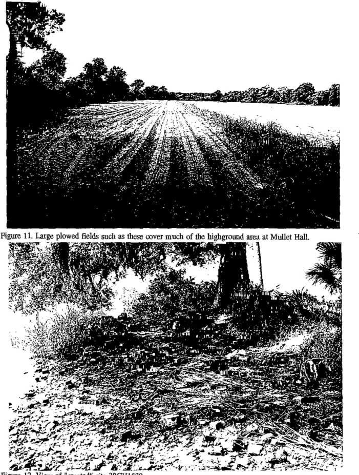
geared more toward locating these sites and visiting areas of high archaeological (primarily Native American) potential (e.g., well drained soils adjacent to creeks). As a result, no formal pedestrian transects were walked, although since access to many sites required walking large agticultural fields, much area was covered in an informal fashion (Figure11).
Metal detecting, using a Tesoro Bandito II™ using an 8-inch concentric coal (electromagnetic type opemting at lOKHz), was also undertaken at selected sites to assist in boundaty definitions. Tbe instrument has the capability to operate in either an all metal mode or <liscriminate mode (which eliminates ferrous metal response). Tbe all metal mode is the industry standard VFL type which does not require motion of the search coil for proper operation. The discriminate mode is based on motion of the search coil, but allows control over the detector's response to ferrous metals. The typical approach was to walk transects across the know or posited site area, with the transects alternating using an all-metal and a <liscrimination mode. Notes of possi'ble "hits" or targets were maintained and used to assist in assigning general boundaries. No effort, dming this stage of the investigations, was made to "ground truth" the various targets.
Figure 11. U!rge plowed fields such as these cover much of the highground area at Mullet Hall
It is anticipated that field notes and artifacts will be accessioned for curation at the South Carolina Institute of Archaeology and Anthropology. Field notes have been prepared for curation using archival standards and will be transferred to the South Carolina Institute of Archaeology and Anthropology as soon as the project is complete. Artifacts will be cataloged using the standard format of the institution and will be transferred to their control within the next several weeks.