Autonomous Navigating Drone with Object
Detection
Achuth Chandra M Archana Vijayan
UG Student UG Student
Department of Electrical & Electronics Engineering Department of Electrical & Electronics Engineering Mar Athanasius College of Engineering, India Mar Athanasius College of Engineering, India
Suraj Rajan Yadukrishnan S
UG Student UG Student
Department of Electrical & Electronics Engineering Department of Electrical & Electronics Engineering Mar Athanasius College of Engineering, India Mar Athanasius College of Engineering, India
Dr. Siny Paul
Professor
Department of Electrical & Electronics Engineering Mar Athanasius College of Engineering, India
Abstract
The goal of this paper is to design and fabricate a multicopter to obtain a stable flight with live video recording, autonomous navigation and video analysis/processing. This paper uses a completely 3D printed frame using Poly Lactic Acid (PLA), brushless dc motors, electronic speed controllers, flight controller, transmitter and receiver, GPS module and Raspberry pi for video processing. This drone also houses a wide angle micro first person view camera (FPV) which allows the user to control and navigate the drone beyond line of sight. It also makes use of technologies like OpenCV (Open Computer Vision) and Python programming to implement autonomous navigation, face recognition, object detection and tracking and obstacle avoidance. By analyzing the video captured and then comparing it with trained datasets, it is possible to identify objects/people in real time for object detection. Keywords: Autonomous navigation, Datasets, Object recognition, Propellers, Flight controller
________________________________________________________________________________________________________
I. INTRODUCTION
Unmanned aerial vehicles (UAVs) are compounding in popularity each and every day. With increasing events of natural disasters, the development of drone to be used in search and rescue operations has turned out to be more important. Drone can be deployed into a catastrophe site very quickly because of less risk. Drones can be designed to provide cost efficient, real time data and imaging, day or night, in harsh conditions and without danger to work force. There are several advantages of designing hex copter instead of quad copter. A pair of leg-like appendages at the bottom allow the machine to land on the ground in a stable manner. The hex copter is a more powerful flyer because of its six propellers than the quad copter, and is also capable of carrying heavier loads. Even if one of those propellers fail, the other five can keep the machine flying. This means motor failure in one of the propellers does not mean the drone will come crashing down, damaging the equipment attached to it. If two propellers fail, the device won’t be able to fly, but it will remain stable enough to reach the ground safely. A hex copter can reach higher altitudes than a quad copter, and also travels faster.
By implementing object recognition and face detection technology using openCV in a drone to navigate it in remote and inaccessible areas, in rescue missions, locating missing people, objects, and even wanted criminals. By analyzing the video captured and then comparing it with trained datasets, it is to identify objects/people in real time. This video along with IR sensors and GPS help in enabling autonomous navigation for drone. Drone technology have huge potential to be incorporated into search and rescue team, not only during disaster but also other searching mission because it can gather image and data over a huge area quickly, lessening the time and the number of rescuers required to find and rescue a lost person, greatly reducing the expense and risks of the missions. The autonomous navigating drone, design and implemented in this paper has great potential to be extended encompassing much functionality.
II. HARDWARE IMPLEMENTATION
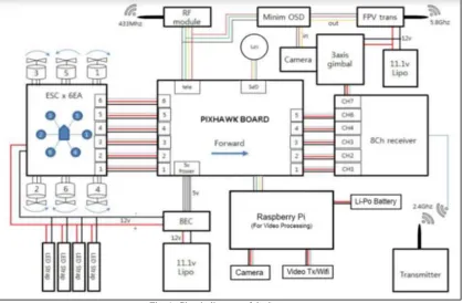
Connection Diagram
Fig. 1: Circuit diagram of the hex copter Methodology
The hex copter basically consist of six Brushless DC motors which are fixed on a completely 3D printed frame. The size of propellers are chosen such that the propellers can produce enough thrust to lift the drone at minimum rpm of BLDC, also considering the factors like better stability and better controllability of the drone. The transmitter uses a radio frequency of 2.4 GHz and the receiver is bound to the transmitter signals before flight. Other components which enables autonomous navigation of the drone includes the real time telemetry, vision system (which uses an FPV camera for recording live videos) and the autopilot controller. The video recorded using the FPV camera is analyzed using softwares like OpenCV to identify humans and detect obstacles. The UAV needs to be modified to enable autonomous operation using on-board processing and control. Once the UAV is able to be operated autonomously, a series of autonomous algorithms will be developed and tested to validate their functionality. A remote access capability will also be developed to allow the operator to interface with the UAV while in operation. The autopilot controller uses a Mission Planner software which takes the path to be travelled as the user input. Based on the data, the autopilot plans its route with the help of coordinates received from the GPS module.
III. DESIGN
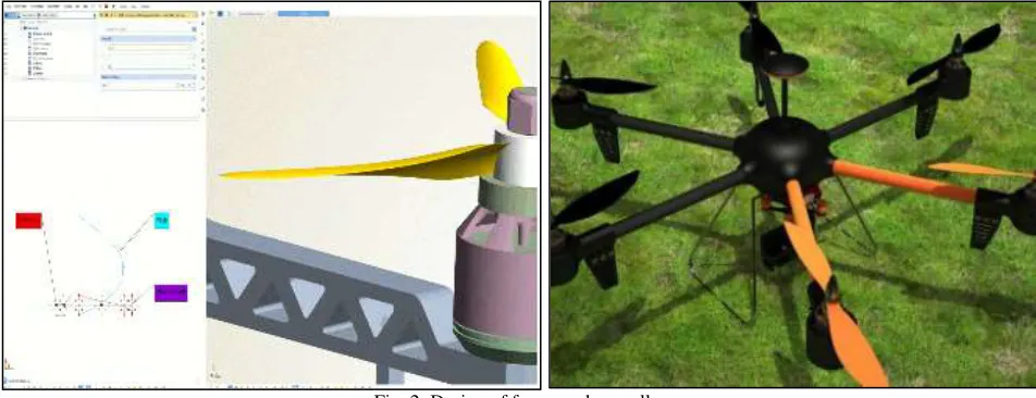
Fig. 2: Design of frame and propeller IV. PROGRAMMING
Programming the Flight Controller
The Flight Controller (FC) used is the pixhawk. The complete program is written in C++ language. The readings taken from inertial sensor, barometer and GPS are read and analyzed by the FC. The sensor readings are passed through an extended kalman filter to smooth out the values. Various flight modes such as stabilize mode, acro mode, altitude hold, position hold are programmed into it.
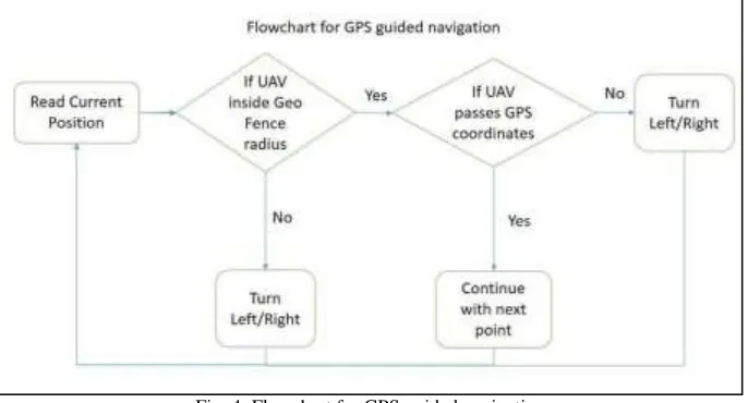
Fig. 3: Flowchart of flight controller programming GPS Guided Navigation Algorithm
Fig. 4: Flowchart for GPS guided navigation Programming for Object Detection
Collect image set of a particular object. e.g.: person. Crop these images for better haarCascade file. Collect negative image set which doesn't contain object. Use openCV to create samples utility to generate positive.vec file for generating variations in image set. Create collection file format.dat file of negative images. Using openCV haartraining utility generate xml file which is called cascade classifier file to detect object. Use openCV for performing real time detection in video. Use vCaptureFromCAM to capture from camera. Use cvQueryFrame to quering frame by frame for processing images to get Reason Of Interest (ROI). Convert image to grayscale image. Use Histogram Equalization method for more accuracy. Using cascade classifier class of openCV load haar cascade xml file generated. Use detectMultiScale method of cascade classifier class to detect object and store them in variable. Iterate the variable so all ROIs are available. Use rectangle function to generate rectangle on ROI.
V. TEST FLIGHT
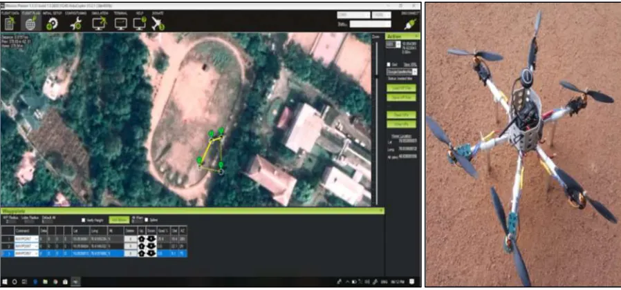
Fig. 5: Images showing the way points and the final product
By analyzing the video captured and then comparing it with trained datasets, it is possible to identify objects/people in real time. In the paper, the drone was trained with 25 different classes of datasets like person, car, mobile phones etc. So that it could detect these trained datasets during flight. The captured video from camera is processed live on board with the help of raspberry pi.
VI. CONCLUSIONS
An Autonomous navigation drone with help of object recognition and GPS coordination was designed and implemented. Each component was tested and verified to be working as intended. Test flights have been conducted and the results confirmed that the hex copter can fly in a stable manner. The drone also has obstacle avoidance capability to avoid collision. Autonomous flight was successfully completed by giving the required GPS coordinates of the places. Live object detection was also done. The tuning of the PID control system was accomplished using custom test benches. Three different PID control systems for pitch, roll, and yaw had been tuned carefully for proper stabilization. The hex copter weighs 1800 grams, maintains an average flight duration of 10 minutes, and can be controlled within a range of 300 meters. The different flight modes such as stabilize, altitude hold, position hold and auto mode, programmed into flight controller were tested successfully. Inspection of high structures, humanitarian purposes or search and rescue missions can be easily performed by this drone.
REFERENCES
[1] Narendra Limbu, Indrajit Ahuja, Harshal Sonar, Sudeep Solanki, Soniya Jain, Hoam Chung, Debraj Chakraborty, "Outdoor Co-operative Control Of Multiple Quadcopters using decentralized GPS localisation", IEEE 10th International Workshop on Robot Motion and Control, July 6-8, 2015
[2] Dror Epstein and Dan Feldman, "Quadcopter Tracks Quadcopter via Real-Time Shape Fitting", IEEE Robotics and Automation Letters, VOL. 3, NO. 1, January 2018
[3] Sonia Waharte and Niki Trigoni[3],"Supporting Search and Rescue Operations with UAVs", 2010 International Conference on Emerging Security Technologies, 7 Sept. 2010
[4] Anjan Chakrabarty and Robert Morris, "Autonomous Indoor Object Tracking with the Parrot AR.Drone", International Conference on Unmanned Aircraft Systems (ICUAS) June 7-10, 2016
[5] Yu-chia Chung and Zhihai, "Low complexity and reliable moving objects detection and tracking for aerial video surveillance using small UAVs", Proceedings of the IEEE , Volume: 89 Issue: 10 Oct 2007