IJRAR19D1001 International Journal of Research and Analytical Reviews (IJRAR) www.ijrar.org 25
Android Project on Advance Mobile DataReceiver
Mr. Jaya S Pujar
Lecture, Department of Computer Science & Engineering,Krishna Murthy Institute of Technology And Engineering, Ghatkesar
ABSTRACT
The advent of new generation of mobile devices required development of applications with functions for automated network measurements. Optimizing the quality of experience of mobile applications over cellular network requires detailed knowledge of underlying network and its performance. The parameter of interest being signal strength, SNR, Clockcorrelation, accuracy. This information is generally not readily available.The application allows the measurement of cellular and wifi network quality by executing active and passive measurements to display or compute the values like MNC,MCC,LAC,CELL-ID. The application also allows access to wifi networks and uses its capabilities to determine the parameters like BSSID,Mac address,channel connectivity and signal strength measured in terms of dbm.This application will provide a solution for comprehensive measurement of various signals along with the signal strength from various transmitters.
Keywords—Diagnostic Tool, Android Device, Mobile Sensors, Receivers and Senders.
INTRODUCTION
The Advance Mobile Data receiver is diagnostic tool which provides the information about the various parameters regarding Cellular and Wi;Fi Network to measure and analyze the network performance. New generation of mobile device enables development of applications as professional measurement system. These mobile application provides detailed information about underlying cellular network and its performance. As per the above information the end user may deduce the available network quality and improve the quality of experience. The Global Positioning System(GPS)is a constellation of satellites that orbit the earth twice a day, transmitting precise time and position(latitude, longitude and altitude) information. with a GPS receiver, users can determine their location anywhere on the earth. Basically ,the satellites broadcast the time and their position .A GPS receiver receives these signals listening to three or more satellites at once,to determine the users position on earth.
PROBLEM STATEMENT
IJRAR19D1001 International Journal of Research and Analytical Reviews (IJRAR) www.ijrar.org 26 METHODOLOGY
a)How gps receiver works and how it displays position with longitude and latitude and other parameters value.
The GPS receiver of mobile device receives signals from various satellites which are available in Celestial Sphere. The Connectivity to various satellites will be displayed inside a Virtual Compass (Rotation Sensor of Mobile Device) using Blue & Red Dots. The Blue Dots represents the Satellites that are communicating with proper good signals, on the other hand the Red Dots represents the Satellites that are communicating with poor or no communication. The GPS Receiver of the mobile device will select the best communicating satellite among these available Satellites. From the best satellites connected the, signals from it will be in the form of Co-ordinates along with other information. Using the information obtained our application will display the following with proper units:
Latitude & Longitude in Degrees
Elevation in meters: Height above sea level in meters.
Bearing: Bearing is used to describe the direction of a destination or object.
Speed in Km: Revolving of satellites speed in orbit.
Declination in degrees: Declination is the angle on the horizontal plane between magnetic north (the direction the north end of a compass needle points, corresponding to the direction of the Earth's magnetic field lines) and true north (the direction along a meridian towards the geographic North Pole).
TTFF in Seconds (Time to Fix First): is a measure of the time required for a GPS receiver to acquire satellite signals and navigation data, and
calculate a position solution (called a fix).
TTLF in time format (Time to Last Fix Obtained): As the mobile device and satellites are stationary, obtaining signals from a set of satellites are not possible, so every time the change insatellite signal
receiving changes the Last Fix will
be updated.
GPS (global positioning system)
The global positioning system (GPS) uses a constellation of 24 satellites orbiting the earths.GPS finds the user position by calculating difference in the times the signals. From different satellites ,take to reach the receiver.GPS signals are decoded.so the smart phone must have in builtGPS receiver.to get access toGPS hardware of android we request using following statement.
Fig1: Global Positioning System
b)Application access WiFi network and
display
the
BSSID,channel
connectivity,and signal strength.
IJRAR19D1001 International Journal of Research and Analytical Reviews (IJRAR) www.ijrar.org 27
c)How
application
access
cellular
network and display the MNC,MCC,LAC
and signal strength.
A cellular network or mobile network is a communication network where the last link is wireless. The network is distributed over land areascalled cells, each served by at least one fixed-location transceiver, known as a cellsite or base station. This base station provides the cell with the network coverage which can be used for transmission of voice, data and others. Our diagnostic tool for cellular network provides information about the type of
Network(GSM/CDMA/LTE),MCC(Mobile Country Code), MNC(Mobile Network Code), LAC (Location Area Code), Cell TowerID,PCI/PSC and Signalstrength
Fig2: Cellular Network Connectivity
IMPLEMENTATION
Java Development Kit (JDK):
The Java Development Kit (JDK) is a software development environment used for developing java applications and applets. It includes the Java Runtime Environment (JRE), an interpreter or loader, a compiler, an archiver , a documentation generator and other tools needed in java development. The JDK
also comes with a complete Java Runtime
Environment, usually called a private runtime, due to the fact that it is separated from the "regular" JRE and has
extra contents. It consists of a Java Virtual Machine and all of the class libraries present in the production environment, as well as additional libraries only useful to developers, such as the internationalization libraries and
the IDL libraries. The JDK forms an extended
subset of a software development kit (SDK). It includes "tools for developing, debugging, and monitoring Java applications".
Eclipse:
Eclipse is an integrated development
environment (IDE) used in computer programming and is the most widely used java
IDE. Eclipse is written mostly in Java and its
primary use is for developing Java
applications, but it may also be used to
develop applications in other programming
languages via plug-ins.The Eclipse software development kit (SDK), which includes the Java development tools, is meant for Java
developers. Eclipse software development
kit (SDK) is free and open-source software.
The Eclipse SDK includes the Eclipse Java development tools (JDT), offering an IDE
with a built-in Java incremental compiler and
a full model of the Java source files. This
allows for advanced refactoring techniques
and code analysis.
Pdanet+
IJRAR19D1001 International Journal of Research and Analytical Reviews (IJRAR) www.ijrar.org 28 EXPERIMENTAL RESULTS
Figure 3:Registration page
Figure 3 show Registration page consist of name, mail ID and password fields. User must enter the necessary details in order to get registered. User can register only once and not more than that.
Figure 4: Login Page
Figure 4 shows User must have to enter the email id and password in order to login. Password length must be greater than six otherwise an error message will be displayed.User enter valid email id and
password to login.
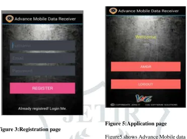
Figure 5:Application page
Figure5 shows Advance Mobile data Receiver application page the user must be Register and login to the application and press AMDR button and access the AMDR Application.
Figure 6: Satellite Module
IJRAR19D1001 International Journal of Research and Analytical Reviews (IJRAR) www.ijrar.org 29 Figure7:Cellular Module
Figure7:CellularModule provides network information about the type of Network(GSM/CDMA/LTE), MCC, MNC, LAC, Cell ID, PCI/PSC and Signal Strength.
Figure 8: WiFi Module
Figure 8 shows the WiFi Module itIdentifies the present capabilities from WIFI Scan List.It helps in getting MAC Address, Channel used & Signal Strength in dBm(decibel milliwatts) of WIFI Signals.
CONCLUSIONS
The main aim of this project is to provide a diagnostic information about the performance of mobile components with the available real time communication.The application will provide a solution for the comprehensive measurement of values with exact units of parameters for various signals.
ACKNOWLEDGEMENTS
We would like to thank Karthik Ganapathi, Managing Director, VSG Software Solutions, Mysuru for his guidance and instructive comments on the content of this paper. We would like to sincerely thank Ashwini K, Joint Director, VSG Software Solutions, Mysurufor her valuable support. We would also like to thank Dr. Reshma Banu, HOD, Information Science and Engineering, GSSSIETW, Mysuru and also we would like to thank Jyothi TAssistant, Professor of Dept. of ISE GSSSIETW, Mysuru and also thank to all the staff members of the department for their constant support and co-operation.
REFERENCES
[1]J Parthasarathy Member Technical Staff,Sun Microsystem Pvt Ltd,India.”position and navigation System using GPS.2006
[2]Ward Philipi,W.Betz,John W and Hegarty,Christopher J, Satellite and signal acquisition Tracking and Data Dimodulation expert from understanding GPS principles and Application by Elliot D Kalpan,Artech house,2005
[3] Fabaim Kaup, Florina Jemrich, David
Househer,”Demonastration of network coverage,A mobile network performance App.”,Fabian Kaup, Florian David Housire peer to peer systems Engineering Lab, technical university, Dharmstatd, 2013
IJRAR19D1001 International Journal of Research and Analytical Reviews (IJRAR) www.ijrar.org 30 [5] Manav Singhal,Anupam Shukla, “Implementation of
Location Based Services in Android using GPS and web services”,IJCSI International Journal of Computer Science,January 2012.
[6]Shafqat Ali shad,Enhong Chen, “Precise Location Acquition of Mobility data using Cell-Id”,IJCSI International Journal of Computer Science,May 2012.
[7]Prof,Seema Vanjire,Unmesh Kanchan,Ganesh
Shitole,Pradnyesh Patil, “Location Based Services on Smart Phone through the Android Application”, International Journal of Advance Research in Computer and Communication Engineering,January 2014.
[8]Anex.A“Global Positionong System Standard