Forestry & Natural-Resource Sciences Last Correction: Apr. 17, 2011
UPGRADING GEOGRAPHIC INFORMATION SYSTEMS TO
SPATIAL DECISION SUPPORT SYSTEMS
J. Van Orshoven
1, V. Kint
1, A. Wijffels
1,2, R. Estrella
2, G. Bencsik
3,
1
P. Vanegas
2,4, B. Muys
1, D. Cattrysse
4, S. Dondeyne
11Department of Earth & Environmental Sciences, Katholieke Universiteit Leuven, Leuven, Belgium 2Universidad de Cuenca, Cuenca, Ecuador
3Institute of Informatics and Economics, University of West Hungary, Sopron, Hungary 4Centre for Industrial Management, Traffic and Infrastructure, K.U.Leuven
Abstract.A GIS is capable of identifying a set of land units meeting positional, temporal, topological
and multiple on-site attribute criteria. Based on the combination of its generic analytical functionalities, a GIS can also be used to rank the alternative land units and propose the best or worst ones in terms of the non-weighted or weighted criteria. More advanced multi-criteria decision methods are however not easily incorporated in the GIS-framework so that extension with dedicated tools is required to upgrade the GIS to a full blown sDSS. In this paper we illustrate this upgrading of GIS to sDSS and we argue that when also temporal alternatives are dealt with, the DSS can be termed spatio-temporal. Three statements are made: (i) the presented rationale is challenged by phenomena of spatial and spatio-temporal interaction, (ii) important research avenues are present in order to optimize topological and off-site decision attributes in the spatial and spatio-temporal decision problems and (iii) the forestry domain is very suitable for study and application of all the mentioned issues due to the explicit spatial and temporal nature of the management issues which must be addressed.
Keywords: Multi-purpose forestry; Decision support
1
Introduction
In forestry choices must frequently be made among alternative actions considering multiple forest performance-related criteria. Depending on the problem at hand, alternatives may be of a spatial (land units), temporal (rotation lengths) or silvicultural (tree species, forest management systems) nature. Performance crite-ria generally apply to quantity or quality of one or more forest ecosystem services and are often combined with cost efficiency. Examples of such services are carbon storage, bio-energy provision, wood production, biodi-versity support, water harvest, nutrient cycling, erosion control and recreational value.
Since all these forest ecosystem services are highly variable among land units, rotation lengths and silvicul-tural practices, forestry-related problems not only deal with multiple criteria but also have a distinct spatio-temporal character. This inherent complexity leads to a clear need for support of the choices or decisions to be made by foresters (e.g., Garcia-Quijano et al., 2005;
Gilliams et al., 2005a; Gilliams et al., 2005b). Though Geographic Information Systems (GIS) are designed for dealing with many aspects of spatio-temporal decision making, current GIS-technology does not have all the required capabilities expected from a full service spatio-temporal decision support system (stDSS) as needed in land management in general and forestry in particular.
The main objective of the present paper is to de-scribe the concept of a GIS-based spatial Decision Sup-port System. To illustrate the concept, we introduce the ForAndesT-sDSS, which was recently developed for support of afforestation planning in the southern Andes of Ecuador (Van Orshoven et al., 2009) using free and open source software (FOSS).
2
GIS for support of spatial decision
making
Geographic Information Systems (GIS) allow users to ask questions about a predefined spatial and thematic portion of geographic reality and obtain meaningful
Copyright c2011 Publisher of theMathematical and Computational Forestry & Natural-Resource Sciences
Van Orshoven et al. (2011)/Math. Comput. For. Nat.-Res. Sci. Vol. 3, Issue 1, pp. 36–??/http://mcfns.com 37
answers (Wijffels et al., 2010). GIS may deal with themes as diverse as transport infrastructure and utilities, land use history and impacts of climate change on agricultural production. All GIS are un-derpinned by a dedicated collection of georeferenced data organized in geodatasets. Each geodataset is representing the considered geospatial entity class or terrain attribute selected from reality at given spatial, semantic and temporal resolutions. A collection of vertically integrated geodatasets is an example of a loosely organized geospatial database. If the data are stored and managed using an object-relational database management system (ORDBMS) like Oracle Spatial (http://www.oracle.com/technology/documentation/ spatial.html) or PostgreSQL/PostGIS (Ramsey, 2007), the geospatial database is said to be tight or integrated. The functionality of a GIS can be broadly categorized into geospatial data management (editing, transforma-tion) on the one hand and information provision on the other hand. The information is generated by the con-version of the data the GIS holds in its database into answers to the questions users ask through a user inter-face. To this end, analytical functions such as proxim-ity and neighbourhood analysis, overlay analysis, cost-distance analysis and map algebra complement the func-tions for viewing, querying and mapping the content of the database.
The analytical functions of GIS make them capable of spatial multi-criteria analysis (sMCA), i.e. the determi-nation of real world entities or real world locations which meet specified positional, attribute, temporal and/or topological criteria. Positional criteria deal with abso-lute geographic location and geometric shape and re-quire spatial functions (e.g., point-in-polygon identifica-tion, area calculation) to be assessed. Attribute criteria are dealt with by query and reclassification functions which use arithmetic, relational and Boolean operators. Temporal criteria relate to changes over time of loca-tion, shape and/or attributes. They are handled through attribute operations, topological overlay or map alge-bra. Topological criteria such as relative distance, spa-tial coincidence, contiguity, connectivity and entity hier-archy can be handled with proximity analysis (buffering, neighbourhood analysis), topological overlay and map algebra. sMCA uses a combination of all these func-tions to determine the set of entities, parts of entities or locations meeting the combination of criteria. sMCA thus defined does not provide a ranking of the members of this set, e.g., from best to worst. Moreover, it is hard to attribute differential importance to the criteria. As a result, sMCA does not sufficiently meet the require-ments when decision makers are in need of a ranking of alternatives according to criteria they or their commu-nities define and weigh.
Similar to sMCA, SAW (Simple Additive Weighting) is a multi-criteria decision method (MCDM) which is, or can easily be, implemented in most standard GIS-software since it is based on topological overlay or map algebra. In contrast to sMCA, SAW does provide a ranking of the alternative entities or locations accord-ing to the multiple selected attribute or temporal cri-teria. Moreover, it allows incorporating differential im-portance of the considered criteria. The Analytic Hier-archy Process (AHP) is an approach for ranking alter-natives which is closely related to SAW, but which has a more elaborate theoretical and mathematical founda-tion (Saaty, 1980). AHP requires the careful assessment of a decision hierarchy consisting of at least four levels: goal, objectives, attributes or criteria with possibly sub-criteria, sub-subsub-criteria, and alternatives. All members in each hierarchy level are weighted using approaches such as those proposed by Saaty (1980) or Malczewski (1999). Weights are then multiplicatively propagated through the hierarchy to create a weighted linear rank-ing of the alternatives. AHP has been integrated in a number of GIS-software packages like IDRISI (East-man, 2003). In both the SAW- and AHP-approach, the decision attributes must be expressed on commen-surate scales, which requires that the values are stan-dardised, typically between 0 and 1. Also, route-finding algorithms are frequently implemented in GIS-software. Route finding implies the search for, and ranking of, al-ternative combinations of network links based on one or more criteria related to the impedance of links and/or nodes.
3
Concept of GIS-based sDSS
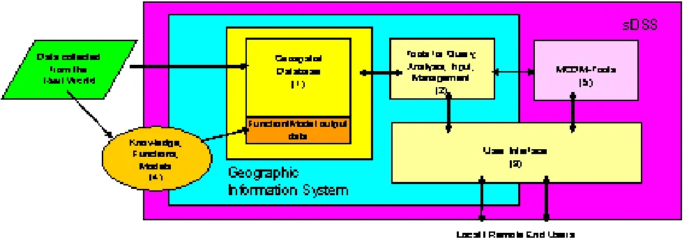
applica-Figure 1: sDSS encompassing a GIS
ble target values. When the best alternatives are to be determined, the initial target values correspond to max-imal values for benefit attributes and minmax-imal values for cost attributes. In each iteration, the target values are adjusted downward or upward so that the probability of finding alternatives increases. Differential weighting of decision criteria is implemented by differential adjust-ment of the target values in each iteration. Large weights correspond to small adjustments, while larger tolerances are associated with small weights. IGP does not require standardisation of the decision attribute values.
In Figure 1, the cyan box represents a generic GIS encompassing (1) a geospatial database, (2) a toolbox for database management, query and analysis and (3) a user interface. The database is populated with data about real world entities or terrain characteristics, and with data generated through a Knowledge and Model Base (KMB, 4). The latter pertain mainly to the pro-jected or simulated performance attributes of particular interventions on particular land units and during par-ticular time lapses. As indicated by the purple box, the sDSS is created by extending the GIS with a MCDM-module like IGP (5).
4
The GIS-based sDSS ForAndesT
The ForAndesT is a spatial decision support system which was developed in a series of research projects on the site-specific environmental and socio-economic im-pacts of afforestation. Its primary objective is to make available the knowledge gained in the research, to sup-port planners and managers of afforestation projects in two catchments in the southern Andes of Ecuador.
The decisions which ForAndesT supports deal in the first place with land units. Land units are the
alterna-tives which must be ranked according to their suitability for afforestation with a given tree species and for a given rotation length. The suitability is dependent upon one or more of five criteria, i.e. attributes of the land units. The five decision attributes are run-off production, sed-iment production, carbon sequestration in soil, carbon sequestration in biomass and income generated, all cu-mulated over the considered rotation length. All of these are intrinsic on-site attributes, and do not exhibit spa-tial interaction with neighbouring land units. The first component of the sDSS is a geospatial database with the land units as objects, each described by the five decision attributes for each of two silvicultural systems (either
Eucalyptus globulus orPinus patula plantations). Land
Van Orshoven et al. (2011)/Math. Comput. For. Nat.-Res. Sci. Vol. 3, Issue 1, pp. 36–??/http://mcfns.com 39
can be used for afforestation, and since the decision at-tributes are available for each land unit, each tree species and two rotation lengths (10 and 30 years), the sDSS is not only capable of ranking land units for afforestation by tree species and rotation length. It can also rank tree species by land unit and rotation length, and rotation length by tree species and land unit as well.
As a result, the user of the ForAndesT-sDSS can ob-tain answers to questions of the type ‘What are the best land units (Where) ?’, ‘What is the best rotation length (How long) ?’ and ‘What is the best silvicultural sys-tem (How) ?’. In our opinion the ‘Where’ capabilities allow the qualification ‘spatial’ for this decision support system’ while the ‘How long’ capabilities are too much dependent upon the temporal attributes in the database to justify the term ‘spatio-temporal’.
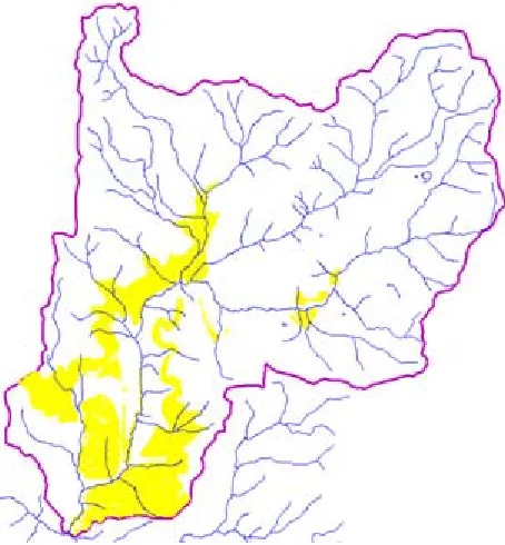
Figures 2 and 3 display the answer provided by the ForAndesT-sDSS to the question: ‘Where in the Taba-cay catchment (6.652 hectares) are the 250 hectares which will deliver the best performance 30 years after conversion of the current land-use to Eucalyptus globu-lusplantation ?’. Herewith the performance is expressed in terms of two of the five possible criteria: (i) income generated (INC) and (ii) carbon sequestered in the soil (SOC). The difference between Figures 2 and 3 is that in the former the ratio of the weights for INC and SOC is 1/3 while in the latter the ratio is 3/1. Compari-son of the figures shows that the selected land units are only partly coincident. In addition, the total area of the selected land units is larger than 250 hectares and not equal. Indeed, since several land units may have identi-cal or very similar values for the INC and SOC-criteria and since in each IGP-iteration the target values are ad-justed with a relatively broad interval it is likely that more than the required area is selected.
5
FOSS in the ForAndesT-sDSS
The ForAndesT-GIS is built upon a geospatial database holding the geometric data (the land units) in ASCII-raster format. The cells in the ASCII-raster are labeled according to the land unit to which they be-long. This label provides the key to a set of relational tables in which all land unit characteristics and forest performance data are held. The latter are maintained and managed using a Free and Open Source Software (FOSS), i.c. PostgreSQL-ORDBMS (Ramsey, 2007). The database model is designed for easy extension to other geographic regions and other decision criteria. An-other FOSS, MapWindow-GIS (Ramsey, 2007), provides the standard geospatial tools to query, visualize and pro-cess the contents of the database. The IGP-module was programmed using the general purpose C# language. Despite the fact that the sDSS is developed making
ex-Figure 2: Land units (>=250 hectares, yelloww) selected as being the best for conversion of the initial land-use-type to Eucalyptus globulus plantation when the objec-tive is to generate the maximal possible income and to store the maximal possible amount of carbon in the soil 30 years after the conversion, while the carbon stored is three times more important than income generated
clusive use of FOSS, the majority of its intended users have the Microsoft Windows operating system, which is why Microsoft’s .NET-framework is an additional soft-ware requirement for making the sDSS operational on Windows-based computers.
6
Discussion of concept and
implemen-tation
Figure 3: Land units (250 hectares) selected as being the best for conversion of the initial land-use-type to
Eucalyptus globulus plantation when the objective is to
generate the maximal possible income and to store the maximal possible amount of carbon in the soil 30 years after the conversion, while the income generated is three times more important than the carbon stored
sediment delivery in the river system draining the water-shed in which an afforestation project is planned. Such off-site criteria are characterized by spatial or spatio-temporal interaction. An intervention on one location at a given time influences the performance of other lo-cations possibly at other times. Obviously, to deal with topological criteria in the absence or presence of spatial interaction, additional tools are required. These may be part of a preprocessing step in which e.g. adjacency is used in a filter operation of eligible pixels. They may also be incorporated in the core sDSS by means of e.g., integer programming techniques (Vanegas et al., 2009a; Vanegas et al., 2009b). However heuristic methods seem to be preferable because of better computational perfor-mance even if the obtained solutions are rather near-to-optimal (Vanegas et al., 2008).
The ‘Where ?’ question as addressed by the ForAndesT-sDSS is limited to one land use type (LUT) at a time. In order to allocate several LUT, an order of priority must be defined. First the LUT with high-est priority will be allocated within the available space. For the second and following LUT, only the remaining space is considered. In order to proceed to simultaneous allocation of several LUT without setting of priorities, a
linear programming approach will be required.
7
Conclusions
In our rationale, a GIS is capable of identifying a set of land units meeting positional, temporal, topolog-ical and multiple on-site attribute criteria using rela-tional operators like ‘equal to’ and ‘larger than’. Based on the combination of its generic analytical function-alities (overlay, reclassification, map algebra, proximity and network analysis) in sMCA, SAW, AHP and route-finding approaches, a GIS can also be used to rank the alternative land units and propose the best or worst ones in terms of the non-weighted or weighted criteria. More advanced MCDM like IGP are however not easily incorporated in the GIS-framework, so that extension with dedicated tools is required to upgrade the GIS to a full service sDSS. When temporal alternatives also are dealt with, the DSS can be termed spatio-temporal but care should be taken not to use this term when merely temporal attributes are involved. The presented ratio-nale is challenged by phenomena of spatial and spatio-temporal interaction and by the wish to allocate multiple land-use types simultaneously without prior judgment of their relative importance. Important research avenues are present in order to optimise topological and off-site decision attributes in the spatial and spatio-temporal decision problems. The forestry domain is very suitable for study and application of all the mentioned issues due to the explicit spatial and temporal nature of the man-agement issues which must be addressed.
Acknowledgements
The core rationale and concepts presented in this pa-per were developed in two major research projects, the AFFOREST-project (2000-2004) funded by the Euro-pean Commission under its 5th framework programme for research and technological development and the ForAndesT-own initiative (2005-2009) supported by the Flemish Interuniversity Council of Belgium.
References
Eastman, J.R., 2003. IDRISI Kilimanjaro. Guide to GIS and image processing. Clark Labs, MA, USA : 328 p.
Van Orshoven et al. (2011)/Math. Comput. For. Nat.-Res. Sci. Vol. 3, Issue 1, pp. 36–??/http://mcfns.com 41
Gilliams, S., D. Raymaekers, B. Muys, J. Van Orshoven, 2005a. Comparing multiple criteria decision methods to extend a geographical information system on af-forestation. Computers and Electronics in Agriculture 49: 142-158.
Gilliams, S., J. Van Orshoven, B. Muys, H. Kros, G.W. Heil and W. van Deursen 2005b. AFFOREST-sDSS, a metamodel based spatial decision support system for afforestation of agricultural land. New Forests, Inter-national Journal on the Biology, Biotechnology and Management of Afforestation and Reforestation, Vol. 30, Nr. 1: 33-53.
Ignizio, J.P., 1974. Interval goal programming and ap-plications. Working paper, Pennsylvania State Uni-versity, USA.
Malczewski, 1999. GIS and multi-criteria decision anal-ysis. John Wiley & Sons Inc. 363 p.
Ramsey, P. 2007. The State of Open Source GIS. Re-fractions Research Inc., 49 p.
Roy, B., 1968. Classement et choix en pr´esence de points de vue multiples (la m´ethode ELECTRE). Revue Fran¸caise d’Informatique et de Recherche Op´erationnelle 8, 57–75.
Saaty, T.L., 1980. The Analytical Hierarchy Process. McGraw-Hill, New York.
Vanegas, P., D. Cattrysse and J. Van Orshoven, 2008. Comparing exact and heuristic methods for site lo-cation based on multiple attributes: an afforestation example. In ‘Computational Science and Its Appli-cations ICCSA 2008’ Volume 5072/2008 of book
se-ries ‘Lecture notes in computer science’, Publisher Springer Berlin / Heidelberg: 389-404.
Vanegas, P., D. Cattrysse and J. Van Orshoven, 2009a. Integer Programming (IP) formulation for minimizing sediment delivery in a watershed by reforestation of optimal sites. 17th International Conference on Geoin-formatics held in Fairfax, USA: 6 p.
Vanegas, P., D. Cattrysse and J. Van Orshoven, 2009b. Compactness and flow minimization requirements in reforestation initiatives: an integer programming (IP) formulation. In ‘Computational Science and Its Ap-plications ICCSA 2009 pt I’ Volume 5592/2009 of book series ‘Lecture notes in computer science’, O. Gervasi, D. Tania, B. Mugante, A. Lagana, Y. Mun and M.L. Gavrilova (Eds.), Publisher Springer Berlin / Heidelberg:132-147.
Van Orshoven, J., A. Wijffels, R. Estrella, D. Cattrysse, F. Cisneros and B. Muys, 2009. From land evaluation to spatio-temporal decision support on afforestation. Proceedings (J.-H. Haunert, B. Kieler, and J. Milde, eds.) of the 12th AGILE International Conference on Geographic Information Science 2009, Hannover, Germany. IKG, Leibnitz Universit¨at, ISBN 2073-8013. (http://plone.itc.nl/agile%5Fold/Conference /2009%2Dhannover)