TRAM NAVIGATION SYSTEM USING SMARTPHONE
M. S. Fredrick Davidson1, PG Scholar and S.Dineshkrishnan2, Assistant Professor Department of Computer Science and Engineering, RVS Faculty of Engineering
Coimbatore, Tamil Nadu - 641 402
ABSTRACT
It is very important to reduce passenger waiting time at tram stops, when tram timetables are unknown by passengers. In order to accomplish that, we propose a tram location and route navigation system by using smart phones. The system is able to easily retrieve information about trams’ locations by GPS, also providing users with the shortest walking route to the nearest tram station. For evaluating the usefulness of this system, we perform a demonstration experiment on an actual "Centrum" LRT system in the center of city. CHAPTER 1 INTRODUCTION 1.1 OVERVIEW OF THE PROJECT
LRT (Light Rail Transit) has been projected as the next generation's transportation system. Recently, “Toyama Light Rail” (of Toyama city, Japan) service has been operating as a next-generation tram in order to revitalize public transportation In order to reduce waiting time at tram stops, passengers would have to obtain live time tables for any tram stop. To achieve this complicated task, we propose a new tram location and route navigation system by using ICT (Information and Communication Technology). The system relays data about the current location of a tram to the smart phone of a tram user. As such, even without
knowing the entire time table, the system enables the users to get on a tram easily by showing the current location information of a tram in real time. For simplicity purpose, instead of getting the location data from the tram directly, we install a smart phone in the tram. The system can then easily collect the tram location data by executing the application from the smart phone in the tram. The application uploads data to the information collection server (Server 1), which stores collected information in a database. Information delivery server (Server 2) delivers the information to the user, so passengers can receive current tram information by accessing a web page generated based on the stored information.
CHAPTER 2
LITERATURE REVIEW 2.1 GLOBAL POSITIONING SYTEM (GPS)
Modern GPS systems have revolutionized navigation and location determination. They work on a very simple principal called trilateration.
Trilateration:
When we refer to GPS, we generally are referring to a GPS, which is the handheld unit we may be looking at GPS is really a group of 27 Earth-orbiting satellites in polar orbit 12,000 miles above earth. Of the 27 satellites, 24 are in use with the other 3 being spares; just in case one fails. The United States military developed and implemented the GPS network to function as a military navigational system. They allowed others to use it but with a built in error known as Selective Availability or SA. President Clinton ordered that SA be discontinued so now everyone has improved accuracy. Each of these 3,500 pound solar-powered satellites circles the globe making two complete trips every day. At any spot on Earth at least 4 satellites are above the horizon. The function of the GPS receiver is to "lock" on to as many satellites as it can find and from the trilateration process it is able to calculate the distance from every satellite to Earth. That in itself is pretty amazing don't you think? Once it knows the distance from Earth to each satellite it then applies a very complex algorithm
(formula) to calculate your location. This is all done by very precisely measuring the time it take for the satellite signal to reach your receiver.
Measuring Distance:
No to go into all of the technical details, which is beyond the scope of this paper suffice it to say that the satellite sends out a radio frequency signal using what is known as a pseudo-random code. Your GPS receiver also internally runs the very same pattern. Because there is a time lag between the internal code and that coming from the receiver, the amount of delay time equals the time it takes the satellite radio signal to reach the GPS receiver.
ANDROID
There is a new open source software toolkit for mobile phones that was created by Google and the Open Handset Alliance. In a few years, it’s expected to be found in millions of cell phones and other mobile devices, making Android a major platform for application developers. Stylish and versatile, modern mobile devices have
become powerful tools that incorporate cameras, media players, GPS systems, and touch screens. As technology has evolved, mobile phones have come about more than simply making calls, but their software and development platforms have struggled to keep pace.
2.2.1 Android Architecture
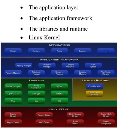
The software stack is split into Four Layers::
The application layer
The application framework
The libraries and runtime
Linux Kernel
Fig 2.1: Android Architecture Applications and Widgets
The highest layer in the Android architecture diagram is the Applications
and Widgets layer. Think of this as the tip of the Android iceberg. End users will see only these programs, blissfully unaware of all the action going on below the waterline. As an Android developer, however, you know better
2.3 JAVA BASICS
2.3.1 Introduction to Java History of Java
Java was conceived by James Gosling, Patrick Naughton, Chris Warth, Ed Frank, and Mike Sheridan at Sun Microsystems, Inc. in 1991. It took 18 months to develop the first working version. This language was initially called “Oak,” but was renamed “Java” in 1995.
Sun formally announced Java at Sun World conference in 1995. On January 23rd 1996,
JDK1.0 version was released.
2.3.2 Features of Java (Java buzz words):
Simple: Learning and practicing java is easy because of resemblance with c and C++.
Object Oriented Programming Language: Unlike C++, Java is
purely OOP.
Distributed: Java is designed for use on network; it has an extensive library which works in agreement with TCP/IP.
Secure: Java is designed for use on Internet. Java enables the construction of virus-free , tamper free systems.
Robust (Strong/ Powerful): Java programs will not crash because of its exception handling and its memory management features.
Interpreted: Java programs are compiled to generate the byte code. This byte code can be downloaded and interpreted by the interpreter.
Portable: Java does not have
implementation dependent aspects and it yields or gives same result on any machine.
Architectural Neutral Language: Java byte code is not machine dependent, it can run onany machine with any processor and with any OS.
High Performance: Along with interpreter there will be JIT (Just In Time) compiler which enhances the
speed of execution.
Multithreaded: Executing different parts of program simultaneously is called multithreading. This is an essential feature to design server side programs.
Dynamic: We can develop programs in Java which dynamically change on Internet (e.g.: Applets).
2.3.3 Java Is Platform-Independent
Java is platform-independent at both the source and the binary level.
2.3.4 Java Is Object-Oriented
Many of Java’s object-oriented concepts are inherited from C++, the language on which it is based, but it borrows many concepts from other object-oriented languages as well. Internet protocols and user interface toolkit functions.
2.2.5 The Java Virtual Machine:
Java Virtual Machine (JVM) is the heart of entire Java program execution process. First of all, the .java program is converted into a .class file consisting of byte code instructions by the java compiler at the time of
compilation. Remember, this java compiler is outside the JVM. This .class file is given to the JVM. Following figure shows the architecture of Java Virtual Machine. In JVM, there is a module (or program) called class loader sub system, which performs the following instructions First of all, it loads the .class file into memory, then it verifies whether all byte code instructions are proper or not.
If it finds any instruction suspicious, the execution is rejected immediately. If the byte instructions are proper, then it allocates necessary memory to execute the program. Variables are locations in memory in which values can be stored. They have a name, a type, and a value. Before you can use a variable, you have to declare it. After it is declared, you can then assign values to it. Java actually has three kinds of variables: instance variables, class variables, and local variables.
Instance variables, as you learned yesterday, are used to define attributes or the state for a particular object. Class variables are similar to instance variables, except their values apply to all
that class’s instances (and to the class itself) rather than having different values for each object. Local variables are declared and used inside method definitions, for example, for index counters in loops, as temporary variables, or to hold values that you need only inside the method definition itself. They can also be used inside blocks ({}), which you’ll learn about later this week. Once the method (or block) finishes executing, the variable definition and its value cease to exist.
Figure 2.4: The internal architecture of the Java virtual
machine.
Java Virtual Machine
In JVM, there is a module (or program) called class loader sub system,
Which performs the following instructions:
First of all, it loads the .class file into memory.
Then it verifies whether all byte code instructions are proper or not. If it finds any instruction suspicious, the execution is rejected immediately. If the byte instructions are proper, then it allocates necessary memory to execute the program.
This memory is divided into 5 parts, called run time data areas, which contain the data and results while running the program. These areas are as follows:
Method area: Method area is the memory block, which stores the class code, code of the variables and code of the methods in the Java program.
Heap: This is the area where objects are created. Whenever JVM loads a class, method and heap areas are immediately created in it.
Java Stacks: Method code is stored on Method area. But while running a method, it needs some more memory
to store the data and results. This memory is allotted on Java Stacks.
PC (Program Counter) registers:
These are the registers (memory areas), which contain memory address of the instructions of the methods. Native Method Stacks: Java methods are executed on Java Stacks. Similarly, native methods
CHAPTER 3 SYSTEM ANALYSIS 3.1 EXISTING SYSTEM
GIS, a more complex mapping technology that is connected to a particular database. Because it’s generic, it is a broader term than the GPS in its technical sense. Thus, GIS is a computer program or application that is utilized to view and handle data about geographic locations and spatial correlations among others.
DISADVANTAGES OF EXISTING SYSTEM:
Merging of cartography, statistical analysis, and database technology. Complex mapping technology No wrong root indication No nearest indication
3.2 PROPOSED SYSTEM
In order to reduce waiting time at tram stops, passengers would have to obtain live time tables for any tram stop. To achieve this complicated task, we propose a new tram location and route navigation system by using ICT (Information and Communication Technology). The system relays data about the current location of a tram to the smart phone of a tram user.
ADVANTAGES OF PROPOSED SYSTEM:
user convenience used for a variety of public transportation applications.
CHAPTER 4 SYSTEM DESIGN 4.1 ARCHITECHURE DIAGRAM
4.1.1. ADVANTAGES
Easy to implement and add function.
Efficient
Communication very fast
Low cost
CHAPTER 5
SYSTEM IMPLEMENTATION 5.1 ADMINISTRATOR MODULE:
Administrator login into system by giving his authentication details such as username and password. After login into the system, The train details are Train name, departure, destination, seat availability, and running days
5.2 PASSENGER LOGIN MODULE
The user can login into the system by providing their credential, if a user is new to this application, and don’t have their credential details such as username and password; he can register as a new member in this system by registering.
5.3 PASSENGER REGISTRATION MODULE
If any user doesn’t have username and password to login into the system He prompt to give his personal and contact information such as name, address, phone number, email id, and he can choose his own username and password. If registration is success then the user can login into the system, by username and password chosen by him/her.
5.4 TRAIN SEARCH MODULE
After successfully login into system, passenger can search the available trains by their requirements. The requirements may departure, destination, journey date. The list of available trains is shown to the user. Then user may select any train and make ticket reservation. If no train is available, then user may change the journey date, departure, or destination.
5.5 TRAIN TRACKING MODULE
The passenger has the options to track the Trains in real time. Trains physical location will show in the map with the place currently train is
travelling. Passenger can select particular train, and then train details such as
previous station, next static, train started date and expected time to reach the next station are shown to the user.
CHAPTER 6
CONCLUSION AND FUTURE ENHANCEMENT
6.1 CONCLUSION
. This system is able to easily receive location information on a tram. The system is most useful for people commuting or shopping incentral urban areas, who would want to use the tram without having to wait at tram stops.
6.1 FUTURE ENHANCEMENT:
In order to improve response speed of route guidance service, it is effective way to pre-calculate the routes between all possible origins and destinations in advance. For route guidance request, it provides route information pre-calculated and stored in a database. However, it is not reasonable approach to prepare the route database for all possible traffic situations. On this
subject, we developed traffic pattern based pre-routing method which provides an approximation of the precise route with real time traffic information. The finite traffic patterns are given by clustering method on traffic information history. Pre-calculation of the routes between all possible origins and destinations is done for each traffic pattern and the calculation results are stored in the database.
The successful implementation and evolution of the EUG NSS Programs requires a continuous involvement of users. To that aim, SUNRISE, a project co-funded in the 7th FP by EC (Galileo area) and managed by the European GNSS Agency (GSA), proposes to establish User Fora addressing the two major markets for
REFERENCE
[1] Toyama city master plan http://www.city.toyama.toyama.jp /division/toshiseibi/toshiseisaku/k eikaku/toshima su/top.htm
[2] D. A. Divis, “GLONASS emerges; Change in ISNS game
plan”GPS World, vol. 7, no. 5, p. 12, May 1996.
[3] “U.S. Senate approves nationwide DGPS funds,” GPS world, vol. 8, no. 9, p. 18, Sept. 1996.
[4] B. W. Parkinson, J. Spilker, Jr., P. Enge, and P. Axelrad,Eds., Global Positioning System: Theory and Applications, vol.2. Washington, DC: American Institute of Aeronautics and Astronautics, 1996.
[5] U.S. DOT and ITS America, “National program plan for intelligent transportation systems: Final draft,” Washington, DC,U.S. Department of Transportation, 1994.
[6] R. L. French, “The evolution of automobile navigation systems in Japan,” in Proc. 49th Annu. Meeting Institute of Navigation ,June 1993, pp. 69–74.
[7] E.Krakiwsky, “IVHS navigation,” GPS World, vol. 7, no. 10,p. 50, Oct. 1996.
[8] S. Honey, W. Zavoli, K. Milnes, A. Philips, M. White, Jr., G. Loughmiller, Jr., “Vehicle
navigational system and method, ”U.S. Patent 4 796 191, Jan. 1989. [9] H. Ikeda, Y. Kobayashi, S. Kawamura, H. Nobuta, Sumitomoelectric’s navigation systems for private automobiles,” in Proc.Vehicle Navigation and Information Systems Conf., vol. 1, 1991, pp. 451–462.
[10] K. Ishikawa, M. Ogawa, S. Azuma, T. Ito, “Map navigation software of the electro- multivision of the ’91 Toyota soarer”. in Proc. Vehicle Navigation and Information Systems Conf., vol. 1,1991, pp. 463–473.