Abstract— Agricultural sustainability requires that the individual farm firm be competitive and profitable while simultaneously enhancing environmental quality and the natural resource base upon which the farm firm and agricultural economy depends. Crop rotation systems are one cropping system alternative that can reduce agriculture's dependence on external inputs through internal nutrient recycling, maintenance of the long-term productivity of the land, and breaking weed and disease cycles. Crop rotation is a time-honored process of planting annual crops. The paper describes methodology and results of crop rotation analysis for Panipat district’(different blocks) of Haryana, climatologically characterized by hot summer, cold winter and dry air except during rainy season. Multi-date & Multi-season IRS LISS-III digital satellite data of 2007-2008 was geo-referenced with the already geo-referenced master image by collecting GCP’s using second polynomial order and Nearest Neighborhood (NN) Resampling approach. The Kharif, Rabi and summer cropping pattern maps and statistics were generated using classified images and applying logical combinations. During Kharif season rice is the major crop which occupies 73,700 ha area and in the Rabi season wheat is major crop occupying 82,900 ha area. In the summer season most of the area is lying vacant as fallow and major crops are fodder, vegetables etc. Sugarcane is an annual crop and it is available in all three cropping seasons. Rice-Wheat-Other, and Rice-Wheat-Fallow and the major crop rotations identified in the district. Major crop rotation is Paddy-Wheat-Fallow occupying 18.41 thousand ha area. .
KEYWORDS- Remote Sensing, Crop Rotation, Cropping Pattern Accuracy Assessment, Satttelite data.
1. INTRODUCTION
Crop rotation is a ―system of growing different kinds of crops in recurrent succession on the same land‖ (Martin, Leonard, and Stamp, Principles of Field Crop Production, 1976). Thus, in the strictest sense, crop rotation is more than just changing crops from year to year based on current economic situations. Rather, it is a long-term plan for soil and farm management. The photo at right shows three crops in a corn-soybean-wheat/red
clover rotation. At the farm management level, crop rotations are used to diversify income, spread labor requirements throughout the year, and spread the crop loss risk associated with overall risk management tool. These basic ecological principles still apply today, although advances in technology and marketing have contributed to shorter or no crop rotations and more specialized agricultural systems. Decisions about planting crops are complex. Crop price fluctuation, input costs, rental agreements, government price supports, weather, choice of farming system and on-farm resources such as animal manures, and other factors all contribute to decisions about crop rotations. Market conditions can have a dramatic effect on crop rotation. An example of this was the national corn acreage in 2007, which experienced an unprecedented 19.5% increase compared to 2006 because of increased demand for corn grain for ethanol production. This increase in corn acreage in 2007 shifted a significant portion of the total corn acreage to second year corn. Continuous corn or corn after corn is also still grown on many dairy farms that have a large demand for corn silage and want to utilize manure derived nutrients more efficiently. This same trend is also evident in the upper Midwest dairy systems.
1. STUDY AREA
Panipat district first came into existence on November 1, 1989. It was carved out of Karnal district. The district status to Panipat sub division of Karnal was again restored on First of January, 1992. The district has one sub divisions namely Panipat and Five development blocks namely Panipat, Samalkha, Madlauda, Israna and Bapauli. This city has strategic at National Highway No.
A Case Study of Crop Rotation Analysis of
Panipat District & Its Development Blocks
Using Geoinformatics
Seema Rani, Rajeev, Manoj Yadav, Ravindra Prawasi, M.P Sharma, R.S Hooda Haryana Space Applications Center (Harsac) CCS HAU Campus, Hisar Haryana, India.
1, just 89 Km. from the national capital. The city has one of the best rail and road connectivity to the state capital Chandigarh and other important commercial hubs of the adjoining states. Panipat is a historical place and was the gateway of India in medieval times. Three battles were fought here and winner of course occupied the Delhi Throne. Panipat is situated in North Eastern Haryana, flanked by River Yamuna on the estern10 border. The Panipat district is surrounded by Karnal in North, Panipat in West and Sonipat district in South and Mujarfarnagar district of Uttar Pradesh in the East. It has a total geographical area of 1267sqkm.
3. MATERIALS & METHDOLOGY 3.1 DATA USED
Remote sensing data is the basic data source for mapping the cropping system of the Panipat district .Indian sensing satellite resource sat (IRS-P6) LISS-III data was used in the present study 23.5m spatial resolution data in Green, Red, NIR and SWIR bands with 24 days revisit The data was used in to drive Kharif, Rabi, & Summer. Cropping patterns . The IRS LISS-III data was the main source of satellite imageries for cretin the spatial maps of cropping pattern, crop rotation map ect.
3.2 METHDOLOGY
Multi-date and multi-season LISS-III digital satellite data was geo-referenced with the master images by collecting GCP’s using second polynomial order and NN Resampling approach. The geo-referenced images were used for further analysis using complete enumeration approach. In complete enumeration approach the administrative boundary of the districts was digitized, a mask generated and superimposed on the geo-referenced image. All the data elements (pixels) within this were extracted for further classification etc. Unsupervised classification approach Iso-Data Clustering classifier was used and class of interest was using ground truth information provided by HARSAC in the form of GPS location.
The Kharif, Rabi and summer cropping pattern maps were generated using classified images and logical combination. The crop rotation maps were generated using Kharif, Rabi and summer cropping pattern maps.
4. RESULTS & DISCUSSION
4.1 Crop Rotation of Panipat District
The crop rotation shows sequential planting of crops in time. Analysis indicate that Panipat district has the major crop rotations of Paddy/Bajra/Jowar/Othercrops Mustard/Wheat-Other crops/Fallow, Paddy-Wheat- Fallow, Bajra-Mustard /Wheat-Other crops, Fallow-Mustard-Fallow and Sugarcane based of three seasons kharif, Rabi and summer in 2007-08
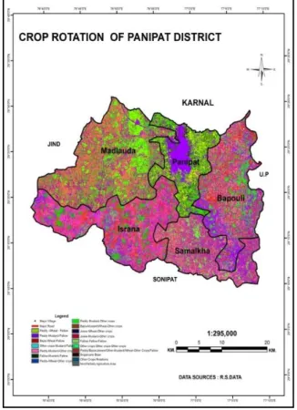
Map 1: Crop Rotation statistics of Panipat District derived from RS data
Table 1: Crop Rotation of Panipat districtderived from RS Data
Crop Rotation of Panipat Block
The Paddy-wheat-mustard-Fallow rotation dominates the western and northern part of the district while the Sugarcane Based rotation dominates the eastern part of the block.
Fig. 2: Crop Rotation of Panipat Block derived from RS Data
Map 2: Crop Rotation statistics of Panipat Block derived from RS data
Crop Rotation Area (000’ha)
Paddy-Wheat-Fallow 2.1
Paddy-Mustard-Fallow 3.1
Bajra-Wheat-Fallow 0.19
Other crops -Mustard-Fallow 0.12 Paddy-Mustard-Other crops 0.04 Fallow-Mustard-Fallow 0 Paddy-Wheat-Other crops 1.1 Paddy-Mustard-Other crops 2.1 Bajra-Mustard /Wheat-Other crops 0.02 Jowar-Wheat-Other crops 0 Jowar-Mustard-Other crops 0 Fallow-Fallow-Fallow 2.1
Other crops -Other crops -Other
crops 4.86
Paddy/Bajra/Jowar/Other crops -Mustard/Wheat-Other
crops/Fallow 4.2
Sugarcane Base 2.03
Other crops Rotation 0.16
Non/Partially Agriculture Area 4.47 Crop rotation Area (000’ ha.) Paddy-Wheat-Fallow 18.41 Paddy-Mustard-Fallow 16.99 Bajra-Wheat-Fallow 2.21 Bajra-Mustard/Wheat-Fallow 2.21 Other crops-Mustard-Fallow 0.07 Fallow-Mustard-Fallow 17.20 Paddy-Wheat-Other crops 1.57 Paddy-Mustard-Other crops 1.53 Bajra-Mustard /Wheat-Other crops 18.14 Jowar-Wheat-Other crops 0.44 Jowar-Mustard-Other crops 0.06 Fallow-Fallow-Fallow 14 Other crops –Other crops
–Other crops 14 Paddy/Bajra/Jowar/Other crops -Mustard/Wheat-Other crops/Fallow 21.50 Mustard-Wheat-Other crops 2.4 Sugarcane Base 8.8
Other crops Rotation 25.58 Non/Partially Agriculture
Crop Rotation of Madlauda Block
Analysis indicates that the block has four major rotation namely Paddy-Wheat-Fallow, Paddy-Wheat-Other crops, Sugarcane Base, Paddy-Mustard-Other crops based on Kharif, Rabi and summer cropping pattern. The area of crop rotation given in Table 3, Figure 3 spatial distribution depicted Map 3
Map 3: Crop Rotation statistics of Madlauda Block derived from RS data
Fig. 3: Crop Rotation of Madlauda block derived from RS Data
Crop Rotation of Samalkha Block
The major Crop Rotation in the block observed Paddy-Wheat-Fallow, Sugarcane based, and Paddy Mustard-Other crops. Statistics of various rotations given in Table-4, Figure4 and Map No.4
Crop Rotation Area (000’ha.)
Paddy-Wheat-Fallow 12.4 Paddy-Mustard-Fallow 2.6 Bajra-Wheat-Fallow 0.3 Other crops-Mustard-Fallow 0.3 Paddy-Mustard-Other crops 2.1 Fallow-Mustard-Fallow 0.0 Paddy-Wheat-Other crops 2.8 Paddy-Mustard-Other crops 0.1 Bajra-Mustard/Wheat-Other crops 0.0 Jowar-Mustard-Other crops 0.0 Fallow-Fallow-Fallow 2.8 Other crops-Other crops-Other crops 8.6 Paddy/Bajra/Jowar/Other crops Mustard/Wheat Other crops/Fallow
0.4
Sugarcane Base 2.7
Other crops Rotations 0.9 Non/Partially Agriculture
Map 4: Crop Rotation Map of Samalkha Block derived from RS Data
Fig. 4: Crop Rotation of Samalkha Block derived from RS Data
Table 4: Crop Rotation of Samalkha Block derived from RS
Data
Crop Rotation of Israna Block
Based on three season cropping pattern major crops rotation derived in the block namely Fallow- Mustard-fallow, other crops-Other crops–Other crops, Paddy- Wheat-Fallow and Paddy-Mustard-Fallow. Crop rotations are given Table 5, Figure 5 and spatial distribution depicted in Map-5.
0 2 4 6 8 P ad dy -… B aj ra -… O ther … Fal lo w -… P ad dy -… Jo wa r-… O ther … Sugar ca n … N o n/ P ar ti …
Crop Rotation of Samalkha Block derived from RS Data
Area (000’ha.)
Crop Rotation Area (000’ha.)
Paddy-Wheat-Fallow 6.7 Paddy-Mustard-Fallow 2.7 Bajra-Wheat-Fallow 0.30 Bajra-Mustard/Wheat-Fallow 0.49 Other crops-Mustard-Fallow 0.04 Paddy-Mustard-Other crops 1.2 Fallow-Mustard-Fallow 0.10 Paddy-Wheat-Other crops 1.3 Paddy-Mustard-Other crops 1.1 Bajra-Mustard /Wheat-Other crops 0.01 Jowar-Wheat-Other crops 0.00 Fallow-Fallow-Fallow 2.08 Other crops-Other crops-
Other crops 7.51
Paddy-Bajra/ Jowar /Other crops-Mustard/Wheat- Other
crops /Fallow 2.3
Sugarcane Base 2.8
Other crops Rotations 0.25 Non/Partially Agriculture
Map 5: Crop Rotation of statistics Israna Block derived from RS data
Fig. 5: Crop Rotation of Israna Block derived from RS Data
Table 5: Crop Rotation of Israna Block derivedfrom RS Data
Crop Rotation of Bapauli block
Based on the analysis of three seasons (Kharif, Rabi, summer) rotations observed in the block are Paddy-Wheat-Fallow, Bajra-Wheat-Fallow, Other crops- Mustard-Fallow and Paddy-Mustard-Fallow. Statistics of various Crop rotation derived given in Table-6, Figure 6 and special distribution depicted in Map 6.
Crop Rotations Area (000ha.)
Paddy-Wheat-Fallow 4.38
Paddy-Mustard-Fallow 4.38
Bajra-Wheat-Fallow 0.44
Other crops -Mustard-Fallow 0.43 Paddy-Mustard-Other crops 0.04 Fallow-Mustard-Fallow 14.7 Paddy-Wheat-Other crops 0.4 Paddy-Mustard-Other crops 0.04 Bajra-Mustard/Wheat-Other crops 0.04 Jowar-Wheat-Other crops 0.01 Jowar-Mustard-Other crops 0.00 Fallow-Fallow-Fallow 3.29 Other crops -Other crops – Other crops 8.49 Paddy/Bajra/Jowar/Other crops -Mustard/Wheat-Other crops /Fallow 0.53 Sugarcane Base 0.45
Other crops Rotation 0.75 Non/Partially Agriculture Area 3.18
Map 6: Crop Rotation of Bapauli Block derived from RS data
Fig. 6: Crop Rotation of Bapauli block derived from RS Data
Table 6: Crop Rotation of Bapauli block derived from RS Data
Conclusion
Crop rotation is a ―system of growing different kinds of crops in recurrent succession on the same land .
Multi-date and multi season optical remote was used to generate seasonal cropping patterns and then crop rotation map of Panipat District and its development blocks using Geomatica 10.3 and Arc GIS software Package
RS data analysis showed that Paddy-Wheat-Fallow, Paddy-Mustard-Fallow, Fallow-Mustard-Fallow and Sugarcane based are the major rotation. Multi-date and multi-season optical data with spatial
resolution of 23.5m from Indian Remote sensing Satellites is formed to be useful for the cropping system analysis of major and contiguous minor crops at block-level. For cropping system analysis of minor and non-contiguous crops high resolution multi-date multispectral data is required.
Crops Rotations Area
(000’ha.) Paddy-Wheat-fallow 5.15 Paddy-Mustard-Fallow 2.56 Bajra-Wheat-Fallow 4.86 Other crops-Mustard-Fallow 4.57 Paddy-Mustard-Other crops 0.80 Fallow-Mustard-Fallow 2.48 Paddy-Wheat-Other crops 0.03 Bajra-Mustard/Wheat-Other crops 0.35 Jowar-Wheat-Other crops 0.52 Jowar-Mustard-Other crops 0.37 Fallow-Fallow-Fallow 3.5
Other crops-Other crops-Other crops 0.96 Paddy/Bajra/Jowar/Other
crops-Mustard/Wheat-Other crops/Fallow 4.00
Sugarcane base 1.82
Other crops rotation 29.93
REFERENCES
Anonymous, 1990. Steps in digital image analysis for crop acreage estimation at regional remote sensing service centers, Status report on crop acreage and production estimation, RSAM/SAC/CAPE/SR/25/90, p.239.
Apan,A., Held,A., Phinn,S. And Markely ,J.(2004),detection sugarcane ―orange rust‖ disease using EO-1 Hyperion hyper spectral imagery. International Journal of remote sensing.
B.N Chattergee, S.Mati, B.K Mandal (1979). Cropping System Theory & Practice.
DAS ,P. (cropping pattern in different Zone, there average Yields in comparison to National average/critical Gaps/Reasons Identified and Yield Potential)
Hooda R S, Yadav Manoj et al., 2008. Estimation of summer paddy in Haryana (India) using high resolution satellite data. Proc. Of International Workshop on Earth Observation & Remote Sensing
Applications, China, 2008,
(1-4244-2394-1/08/$20.00©2008IEEE).
I.M.F ―Geography as it provides a good base for regional (1999)‖
Kaushik, N. and Kumar V. (2003). Khejri (Prosopis cineraria)- based agro-forestry system for Haryana, India. Jour. Of Arid Environments, 55, 03, Nov.2003, 433-440 pp.
Lilisand T .M. , Ralph W, Chipman J. W. (2003). Remote sensing and Image interpretation. John Wiley and Sons, 2003, 789 pp.
Mobushir Riazkhan; university of twenty, the Netherlands (2011) crops from space.
Panigrahy Sushma, Hooda R S, Ray S S, Yadav Manoj, Manjunath K R, Sharma M P et. al. (2008). Cropping system analysis using remote sensing & GIS : Haryana state. Scientific Note: EOAM/SAC/CS/SN/02/2008. 92 pp.
Patel N K, Medhavy T T, Hussein A, Sarangi B K and Mohanty R R, 1993. Paddy production forecasting for Orissa during 1992-93 kharif season
using remote sensing data. Scientific Note : RSAM/SAC/CAPE-II/SN/15/93.
Roy P.S ( 2000) The application of Remote Sensing. Shanwad U. K., Patil V. C. and Gowda H.H. (2002).
Precision Farming: Dreams andrealities for Indian agriculture. Proceeding of Asian GPS Conference.
Shiva kumar,M.K.V,ROY P.S.
Harmesh,K.Sah,S.K(2003) ―Sattlite Remote sensing and GIS applications in agriculture Metrology‖. Singh, Ambika ( Hand Book of Agriculture 1980) Wani G. M. and Sikka V. M. (2009). Drought
situational analysis of cropping in Rajasthan. Abstract to Second visit to Rajasthan.
Yadav Manoj et al., 2008. Monitoring area under santhi (summer) paddy in Haryana using high resolution satellite data. Bull. Of the National Natural Resources Management System (NNRMS), Vol. 32, February 2008, 15-21 pp.