Published Online May 2012 in MECS (http://www.mecs-press.net) DOI: 10.5815/ijeme.2012.05.09
Available online at http://www.mecs-press.net/ijeme
The Attendance Management System Based on Micro-cellular and
GIS technology
Jianfeng ZHU, Zhuang LI, Yuchun MA
dept. Electronics and Information Engineering, Qiongzhou University, Sanya, China
Abstract
This paper puts forward the composition of geospatial information and its definition. The author designed and implemented the attendance management system based on Micro-cellular and the geographic information system(GIS) technology. The function of the geographic information system(GIS) was achieved by transforming Japan Geographical Survey Institute's Digital Map 2,500 base plate data into G-XML data. The function of location information system was accomplished according to micro-cellular mobile terminal-in the GIS's Real-time positioning and tracks. At last, the attendance management system based on micro-cellular and GIS technology was implemented by comparing the work schedule with the mobile tracks of its related mobile handheld terminals.
Index Terms: Microcell; g-xml; gis; attendance management system
© 2012 Published by MECS Publisher. Selection and/or peer review under responsibility of the International Conference on E-Business System and Education Technology
1. Introduction
The so-called geography spatial information includes the positional information and the geography information. The positional information refers to the spatial information (three dimensional position coordinates) and the time information. The geography information refers to buildings, roads' names, attributive information of addresses and the related information etc. Along with the development of mobile communication networking and geography information technology, geospatial information applications which are the combination of moving body location information service and geographic information system receive wide attention.
Recently, many Japanese companies have introduced a variety of attendance management system. For example, IC card access control system, IC card attendance management system[1], radio frequency identification RFID card attendance management system[2]. The applicable object is the attendance of employees at fixed work time and fixed work place. However, when work time and work place change, the problem of employees’ attendance is still difficult to resolve. For example, the field operations staff. In order to resolve the problem of field operations staff attendance, the author completed the mobile handheld PHS
(Personal Handy-phone System) location information system which is based on micro-cellular technology, designed and tested attendance management system etc. The attendance management system is based on the combination of PHS (Personal Handy-phone System) location and geographic information system, it makes the information query function which includes where the holder is at a time become true. According to comparing the field operations staff work schedule (place, time) which was pre-entered in the database with the trajectory (place, time) of PHS (Personal Handy-phone System), the attendance management system automation is achieved.
2. The Components of Attendance Management System Based on Mobile Handheld Location Information
The attendance management system which is based on mobile handheld location information consists of the following components:
Mobile Handheld (such as PHS) Micro-cellular base station
Mobile Handheld location information service center Attendance Management System
Terminal PC
Mobile Handheld location information service center sometime is responsible for the timely and regular collection of Mobile Handheld location information (longitude, latitude coordinates) and sends them timely and regularly to attendance management system. According to the demand of PC side for real-time and regular employees’ attendance, the attendance management system is responsible for sending requests for information about location of the current mobile handheld to locate information service center timely and regularly, receiving mobile handheld location information (longitude, latitude coordinates) at a time from service center timely and regularly, indicating the mobile handset location information in the GIS, and transmitting it to the Terminal PC. At the PC side, the terminal PC sends the mobile handheld's attendance requirements to the Attendance Management System , receives the immediate and regular mobile handset location information which is marked on the GIS, then, according to the schedule information which is the same as accepted mobile handset, We can determine the attendance results and achieve attendance management after comparing with time and location.
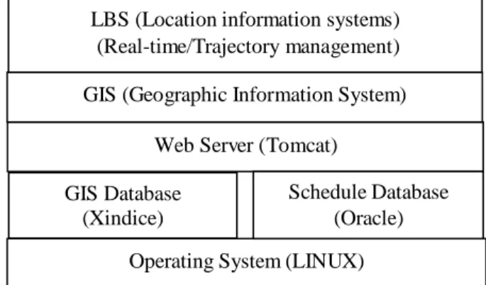
Figure 1.mobile handheld location information-based attendance management system
Operating System (LINUX) GIS Database
(Xindice)
Web Server (Tomcat) GIS (Geographic Information System)
LBS (Location information systems) (Real-time/Trajectory management)
Schedule Database (Oracle)
3. Implementation of Geographic Information System The GIS consists of the following function modules.
The XML module of geographic data is responsible for converting Digital Map 2500 base plate data file into a G-XML (Graphics Based XML) data file [3]. Digital Map 2,500 is a Construction of the GIS data set, which is composed by figure-leaves--the basic land of 1:2,500 is to a figure, released by the Geographical Survey Institute of Japan. A figure has 7 layers: administrative region and coastline, block, road center line, railway and railway station, some places such as the surface of the water, airports, parks and other venues, public buildings, geodetic reference triangle points. A figure of data corresponds to a G-XML document. The G-XML document is a document based on XML standards, composed by the measurement of geographical space, phase geographical space, caring place, paths, and painted portraits of body.
G-XML module for processing file data stores the G-XML documents in GIS database based on Xindice technology to finish some operations of G-XML files such as appending, updating, deleting, query and so on.
The conversion function module of geographic coordinates is responsible for transforming grid coordinates of G-XML document into the computer screen coordinates.
The function modules of depicting vector map is responsible for transforming the G-XML files into SVG (Scalable Vector Graphics) format files, it can depict vector map according to the SVG files, it means that depicting digital map layer by layer in order , it contains administrative areas, parks, the surface of the water, transport facilities, roads, buildings, text data. According to the using purpose, the data of 7 layers is choosen for different combinations to describe. The basic description method is to set the size of the surface features (point, line, surface) and to color the ground and objects.
The GIS WEB server uses the architecture of Tomcat web system, J2EE technology, Xindice database, SVG technology, etc.
4. The Implementation of Mobile Handheld Location Information System (LBS)
The mobile handheld terminal location was marked in corresponding position on the vector map accurately by the mobile handheld location information system (LBS), which is mainly implemented by the following function modules.
The coordinate conversion function module is responsible for transforming the location of mobile handsets longitude coordinates and latitude coordinates which are received from the mobile handset service center location information into the plane rectangular coordinates. It means that the location of mobile handsets is the actual location of the base station which is the nearest from the mobile handset. The maximum theoretical error of using the base station is 500 meters. Of course, the error is determined by the distance between base stations. The closer the distance between the base stations, the smaller the error.
The figure sector inquiry function module inquires the Xindice database to get the figure pages (G-XML file) which contains the plane rectangular coordinates according to the plane rectangular coordinates of the location of mobile handsets. In order to mark the location of mobile handsets in the central region, the most relevant 9 figures needs to be check -ed out
The position coordinates conversion function module is responsible for transforming the plane rectangular coordinate of the location of mobile handsets into the coordinates system of the computer screen coordinates.
The figure-depicting function module is responsible for transforming the most relevant 9 figure (G-XML files) into a file group, which is composed of 9 SVG (Scalable Vector Graphics) files, and depicting the vector group according to the file group.
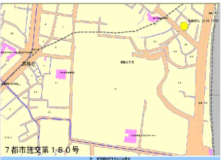
The mobile handset location identification module is responsible for marking the location of mobile handsets (including the date and time information), in corresponding position on the vector map with a small icon.
The figure 2 showed the achieving result of the marking of mobile handheld devices’ location information, which identified the location of Mr. Honda at 10:18 on November 14 in the figure.
This work is supported by Hainan educational department fund (Hjjsj201020), Sanya university specialized fund (2010YD27), rdzwkfjj001 and 2009BADA1B03.
5. The Attendance Management System
The Preconditions for achieving this system are as follows: First, employees switch on the mobile handsets and set the location information query function to be effective status; Second, the enterprise of attendance management system and the mobile handheld location information service center sign the contract as follows: the center of location information service should collect location information of the mobile handheld terminal regularly and irregularly and send them to the enterprise timely.
Collecting mobile handset location information regularly is that the service center of mobile handset location information collects the location information of mobile handset in a specified time interval everyday. For example, at 08:00 am~18:00 pm from Monday to Friday, collecting location information of the mobile handheld terminal one time every 20 minutes. For one of the mobile handsets, the location information of mobile handsets needs to be collected 31 times regularly everyday.
Collecting mobile handset location information irregularly is that the service center of mobile handset location information collects the required location information of mobile handset instantly according to the temporary requirements from the side of attendance management system. For example, the service center of mobile handset location information receives a requirement of attendance management system at 10:17 on Saturday which requires inquiring about the location information of three mobile handsets owned by attendance management system side immediately. Then the service center of mobile handset location information collects the location information of the three mobile handheld terminals soon and sents it to the attendance management system side immediately.
The attendance management system mainly consists of the function modules as follows:
The mobile handset location information request module is responsible for sending the requirement which can obtain real-time location information of mobile handset to the location service center. The sending format is HTTP file, the contents are phone number, request time, request type of the mobile handset and so on.
The mobile handset location information response module is responsible for translating the location information (latitude and longitude, time, etc.) of the mobile handset which is received from the service center of location information into a plane rectangular coordinates (time, location). After that, this module inquires GIS databases to obtain the location information (administrative location, etc.) of the coordinates, and inputs the spatial location information (time, administrative position, etc.) to the schedule database of the employee attendance management system.
The schedule management function module is responsible for inserting, updating and deleting the work schedule record of the employee. The work schedule mainly consists of employee names, phone numbers of the mobile handsets, address of workplace, working hours and other projects.
The attendance management function module is responsible for comparing the work schedule with the actual action trajectory (time, location) of the mobile handheld according to the work schedule. If the location of the actual action matches with the schedule address (in the range of allowable error), the attendance result is normal, otherwise, the attendance result is abnormal.
The location-expressing function module of mobile handsets is responsible for expressing the current position and the trajectory of mobile handsets.
The current location expressing function of mobile handsets is responsible for marking the present position of the specific or complex real-time mobile handsets on the vector map.
The mobile trajectory-expressing function module of the mobile handset is responsible for marking the passed location information and time information on the vector map.
Figure 2. The Implementation of Location Information System
6. The Problem Unsolved In the Attendance Management System
The attendance system marks the location information on the SVG vector map with a small icon (icon). Because the small icon is not text-based format, the small icons which are used to identify the location can not be zoomed in or out with the SVG vector map synchronously when the SVG vector map is zoomed in or out. The issue is shelved after this project was over. When using Google Maps recently, the same problem has been found out. Obviously, this problem is a common problem that the industries have to face.
7. Conclusion
The mobile handheld location information attendance management system is an attendance management system based on Micro-cellular technology substantively which has resolved the employees’ attendance when work time and work place constantly change. This technique not only is used for attendance management system but also plays a lot of role in Tourism building such as resource scheduling, tour guide, looking for objects tracing and emergency rescue. Ultimately, it can achieve providing services for all the people and all the things at any time (anytime) and anywhere (anywhere) [4].
The GIS data of the system is from Japan Geographical Survey Institute's Digital Map 2,500 base plate data (spatial data base plate). However, the in-depth discussion and consensus standards which is about geographic information system in China have not formed yet. In order to be geared to international standards, the international standards of GIS (geographic information systems) and LBS (location based on service) should be translated into the Chinese national standard as soon as possible[5].
References
[1] S. Lu, L. Pan, Non-contact IC card attendance management system [A], China Institute of Metrology, 2001,12 (3): 59-63. (in Chinese)
[2] L. Wang, R. Qin, Accesses control system based on RFID technology, access control system [J], Microcomputer Development, 2003,13 (11): 59-60 +63. (in Chinese)
[3] G-XML, <http://gisclh.dpc.or.jp/gxml/>
[4] D. Li, Q. Li, Z. Xie, Y. Zhu, On the spatial information and the integration of mobile communications applications [A], Information Science of Wuhan University, 2002,27 (1): 1-8. (in Chinese)
[5] J. B. He, J. T. Jiang, Standardization of Geographical Information Review and Consideration [J], Surveying and Mapping, 2006, 31 (3): 9-12 +3. (in Chinese)