Evaluating the Source of Pb and Sr in North Carolina Surface Waters
By Paige Cary
Senior Honors Thesis Geological Sciences
University of North Carolina at Chapel Hill
April 27, 2018
Approved:
___________________________
Dr. Drew S. Coleman, Thesis Advisor
Abstract
Lead and strontium concentrations and isotopic compositions of surface water samples
collected across the state of North Carolina have been evaluated to determine the predominate
contributor of each element to the water. Strontium isotope systematics in NC surface waters are
reflective of the underlying bedrock geology and the influence of seawater in the Coastal Plain.
The lead isotopic data is decoupled from the strontium data and displays no trends with relation
to bedrock geology, though there may be some evidence of natural lead contribution to river
waters in the Blue Ridge Belt. Most lead isotope ratios fall within or very close to the range for
eastern U.S. leaded gasoline, suggesting that the source of lead in North Carolina surface waters
is primarily anthropogenic.
Introduction
A recent study of Sr and Pb isotope ratios along the Neuse River Basin of North Carolina
conducted by Watts et al. (2018) revealed the necessity of analyzing the Pb isotope data of NC
rivers in order to determine the major contributing source of Pb to NC surface waters. It was
found that whereas 87Sr/86Sr ratios vary in response to geologic and environmental influences
from the headwaters of the Neuse, downstream, 206Pb/207Pb ratios remain invariant along the
length of the Neuse River. Furthermore, 206Pb/207Pb ratios of Neuse River samples fall within the
range for eastern U.S. leaded gasoline, suggesting that Pb in the Neuse River Basin is derived
from an anthropogenic source.
It is possible to pinpoint the source(s) of dissolved constituents in natural waters by
comparing the isotopic signatures of those constituents to those of their suspected sources.
subsurface diabase dikes through which groundwater flows and feeds the surface water (Watts et
al., 2018). 87Sr/86Sr ratios rise as the Neuse River flows through the Coastal Plain (Figure 1) and
level off at the coast at around 0.709, the modern approximation for the 87Sr/86Sr ratio of
seawater (Palmer and Edmond, 1989). The consistency of 87Sr/86Sr ratios with subsurface
geology and their reflection of the influence of seawater along the Neuse River Basin lead Watts
et al. (2018) to suggest that the sources of Sr to the Neuse River are primarily geologic and
environmental.
These isotopic fingerprinting methods can be applied to naturally occurring dissolved
solutes as well as environmental contaminants, as evidenced by studies which relate Pb isotopes
in Atlantic Ocean waters to multiple continental sources (Noble et al, 2015; Veron et al, 1994).
Lead isotope ratios along the Neuse River are consistent with U.S. leaded gasoline (Watts et al.,
2018). We conducted a statewide survey of Pb and Sr isotopes and concentrations of NC river
waters in order to determine whether the same patterns in Pb and Sr isotopes documented along
the Neuse River are present across NC river basins as a whole.
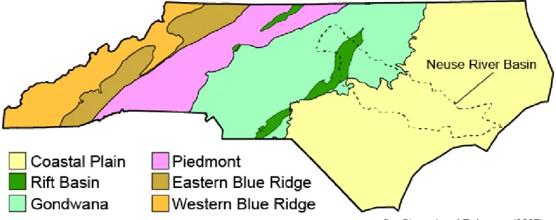
Geologic Setting
The rivers of North Carolina flow through a number of diverse rock types. The geology
of North Carolina can be simplified into a series of belts and terranes which grade into one
another moving west to east (Figure 1). The Blue Ridge Belt is the westernmost and oldest of
these geologic units, located within the Appalachian Mountains, and consisting primarily of
Precambrian and Early Paleozoic metaigneous and metasedimentary rocks, particularly granitic
gneisses, paragneisses, and schists (Hatcher and Goldberg, 1991).
Adjacent to the Blue Ridge Belt is the Piedmont Terrane, which consists of Middle to
Late Proterozoic basement rock and Paleozoic metamorphic and plutonic rocks (Horton and
McConnell, 1991). East of the Piedmont Terrane are the Gondwanan Terranes, which encompass
the Charlotte Belt, the Carolina Slate Belt, and the Raleigh Belt. The Gondwanan Terranes
consist primarily of Paleozoic metamorphic and plutonic rocks (Stuckey, 1965). Located within
the Gondwanan Terranes is the Triassic Rift Basin, consisting of Triassic sedimentary deposits
cut by Jurassic diabase dikes (Ragland, 1991). The Coastal Plain is comprised of unconsolidated
gravels, sands, silts, and clays ranging in age from the Cretaceous to the present (Stuckey, 1965).
In general, the geology of North Carolina decreases in age from west to east. Because
these geologic units align themselves approximately northeast-southwest moving laterally across
the state, much of the data presented in this paper is plotted against longitude in order to detect
Methods
Surface water samples were taken across the state of North Carolina from streams
flowing over a range of diverse geologic settings, from the mountains to the Coastal Plain. In
total, 49 water samples have been collected for this project.
All samples were collected in flux cleaned polyethylene bottles. The samples were passed
through 0.45 m filters and acidified with clean HNO3 upon collection. For Sr isotopic and
concentration analysis, 10-15 mL of water was spiked with a tracer enriched in 84Sr, then dried
down and dissolved in 3.5N HNO3. For Pb isotopic and concentration analysis, 30-40 mL of
water was spiked with a 205Pb tracer and dissolved in 1.1 HBr. Samples were passed through
element-specific ion exchange chromatography columns in order to isolate each element for
analysis.
Concentrations of Pb and Sr, and isotopic ratios were determined by isotope dilution
thermal ionization mass spectrometry (ID-TIMS). Isotopic ratios of Sr were normalized to
86Sr/88Sr = 0.1194 assuming exponential fractionation behavior. Replicate analyses of NBS-987
standard yielded 87Sr/86Sr = 0.710266 ± 0.000016 (2 n = ) which provides the best estimate
of uncertainty in Sr ratios. Lead isotopic ratios were corrected for fractionation assuming 0.14%
± 0.07%/amu on the basis of replicate analyses of NBS-981. Uncertainty in Pb isotopic ratios is
dominated by fractionation uncertainty.
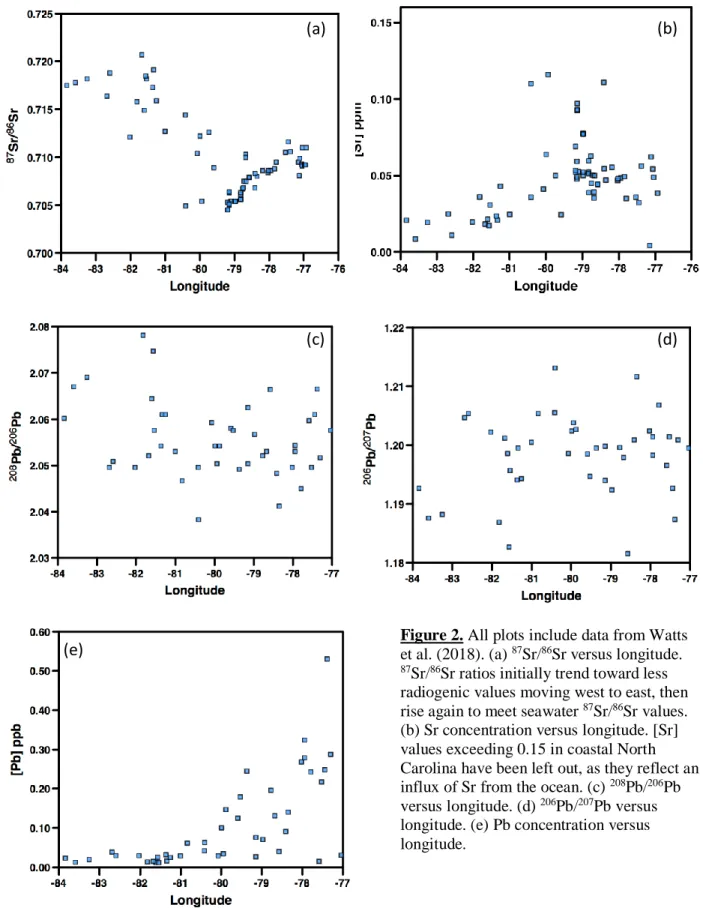
Results
87Sr/86Sr values range from 0.704 to 0.721. A plot of 87Sr/86Sr versus longitude (Figure
2a) shows how the Sr isotopic composition NC of surface waters changes from west to east
across the state. 87Sr/86Sr ratios reach a maximum value of approximately 0.721 in the Blue
Figure 2. All plots include data from Watts et al. (2018). (a) 87Sr/86Sr versus longitude. 87Sr/86Sr ratios initially trend toward less radiogenic values moving west to east, then rise again to meet seawater 87Sr/86Sr values. (b) Sr concentration versus longitude. [Sr] values exceeding 0.15 in coastal North Carolina have been left out, as they reflect an influx of Sr from the ocean. (c) 208Pb/206Pb versus longitude. (d) 206Pb/207Pb versus longitude. (e) Pb concentration versus longitude.
(a) (b)
(c) (d)
Terranes and the Triassic Basin. 87Sr/86Sr ratios then rise again through the Coastal Plain and
level off between 0.709 and 0.712.
Sr concentration values range from 0.004 to 0.76 ppm. Sr concentrations rise with
decreasing 87Sr/86Sr ratios. Figure 2b does not include samples with Sr concentrations higher
than 0.15, as they are located in estuaries and reflect an influx of ocean Sr. Excluding these
samples, the maximum Sr concentration values coincide with the minimum 87Sr/86Sr values.
The Pb isotopic data display no trend with respect to longitude (Figures 2c and 2d).
208Pb/206Pb values range from 2.038 to 2.078, and 206Pb/207Pb values range from 1.182 to 1.213.
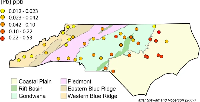
The concentration of Pb ranges from 0.012 to 0.53 ppb. The concentration of Pb increases
significantly, though gradually, from west to east, and there is a considerable spread in
concentration values in the eastern part of the state (Figures 2e and 3).
Discussion
The Sr isotopic data are reflective of the underlying geology. 87Sr/86Sr values are highest
(most radiogenic) in the Blue Ridge Belt, which is expected from the oldest rocks in the state.
The ratios are also consistent with 87Sr/86Sr values of bedrock in the Blue Ridge Belt (Stueber,
1969). 87Sr/86Sr ratios trend downward toward the east as the rivers pass through progressively
younger geologic units. The isotopic ratios are consistent with bedrock values for the Piedmont
and Gondwanan Terranes (Fullagar et al., 1997). The 87Sr/86Sr overlap those recorded by Watts
et al. (2018) at the headwaters of the Neuse River, and then rise through the Coastal Plain to
meet the 87Sr/86Sr ratio for seawater, about 0.709. 87Sr/86Sr ratios above 0.709 in the Coastal
Plain are interpreted as being influenced by agricultural runoff (Watts et al., 2018).
Additionally, 87Sr/86Sr values have a tendency to decrease in silicic rocks with increasing
Sr concentration (Palmer and Edmond, 1992). This pattern is reflected in our surface water
samples (Figures 2a and 2b). Higher Sr concentration values associated with lower 87Sr/86Sr
ratios in the Gondwanan Terranes may correspond with Jurassic diabase dikes.
The lack of variation of the Pb isotope data with longitude, and therefore geology, is
suggestive of an anthropogenic source. This is strongly supported by plotting the Pb isotope data
for the surface water samples against Pb isotope data for NC bedrock and U.S. leaded gasoline
(Figure 4). The majority of surface water samples fall within or very near the Pb isotope range
for U.S. leaded gas. However, there is some indication that natural Pb may be contributing to the
Pb isotope ratios of samples in the Blue Ridge Belt, around longitude -82, with noticeably higher
208Pb/206Pb ratios than the rest of the samples, which is expected from older rocks in western
North Carolina (Figure 2c). Despite the hint of natural Pb which observed in these samples, they
Figure 4. Pb isotope data for NC surface water samples is plotted against whole rock Pb data for NC bedrock from Fisher et al. (2010) and the Pb isotope range for U.S. leaded gas after Komárek et al. (2008).
The United States phased out of its use of leaded gasoline in the 1970’s (Nriagu, 1990).
Leaded gasoline is no longer in widespread use, though it appears to be the primary contributor
of Pb to North Carolina surface waters. It is highly likely that Pb which accumulated in soils
while leaded gas was still in use is being leached from the soil by groundwater and incorporated
into streams (Teutsch, 2001).
There are several potential explanations for the gradual increase from low to high Pb
concentration across the state (Figure 3). The first is that Pb is accumulating in surface waters
across North Carolina from west to east. However, this is highly doubtful, since drainage basins
in the eastern part of the state are not connected to those in the western part of the state, and there
is no way of transferring material between them. The second is that the higher concentrations
which we observe in Eastern North Carolina are attributed to higher population density in that
part of the state. Though this may be a significant contributing factor, especially considering that
observed between low concentration values in the west and high concentration values in the east.
A more plausible explanation for the low to high concentration gradient across the state is
the decrease in elevation and topography over the transition from the mountains to the Coastal
Plain. As river gradients decrease across the state, the flowing water has more time to interact
with the soil, from which the anthropogenic Pb is likely being leached by river waters. As rivers
in the Coastal Plain begin to stagnate, they accumulate more Pb over time, as opposed to
quick-flowing streams in the mountains. There is also a much higher percentage of suspended sediment
and particulate matter in slow-moving streams in the east, which interacts with the surrounding
river waters and potentially contributes to the higher Pb concentrations observed in the east.
Conclusions
87Sr/86Sr values of surface waters across North Carolina are strongly reflective of the
underlying geology. Isotope ratios of Pb, however, display no trends with respect to geology, and
fall within or very close to the range for eastern U.S. leaded gasoline. This suggests that whereas
Sr in North Carolina rivers can be attributed to geologic and environmental factors, Pb is
Acknowledgements
I would like to thank the North Carolina Policy Collaboratory for supporting this project.
Special thanks to my advisor Dr. Drew Coleman, as well as TIMS Facility Manager Dr. Ryan
Mills for overseeing the analytical process. I would also like to thank the graduate students in the
Isotope Geochemistry Lab, including Amanda Crenshaw, Sean Gaynor, and Josh Rosera, as well
as undergraduate student Elena Watts for sharing her data and answering questions. Finally, I
would like to thank Dr. Steven Singletary and students at Robeson Community College for
References Cited
Fisher, C.M., Loewy, S.L., Miller, C.F., Berquist, P., Van Schmus, W.R., Hatcher Jr, R.D.,
Wooden, J.L. and Fullagar, P.D., 2010, Whole-rock Pb and Sm-Nd isotopic constraints
on the growth of southeastern Laurentia during Grenvillian orogenesis: Bulletin, v. 122,
p.1646-1659.
Fullagar, P.D., Goldberg, S.A., and Butler, J.R., 1997, Nd and Sr isotopic characterization of
crystalline rocks from the southern Appalachian Piedmont and Blue Ridge, North and
South Carolina, in Sinha, A.K., Whalen, J.B., and Hagen, J.P., eds., The Nature of
Magmatism in the Appalachian Orogen: Geological Society of America, p.165-180.
Hatcher, R.D., Jr., and Goldberg, S.A., 1991, The Blue Ridge Geologic Province, in Horton,
J.W., Jr., and Zullo, V.A., eds., The Geology of the Carolinas: The University of
Tennessee Press, p. 11-35.
Horton, J.W., Jr., and McConnell, K.I., 1991, The Western Piedmont, in Horton, J.W., Jr., and
Zullo, V.A., eds., The Geology of the Carolinas: The University of Tennessee Press, p.
36-58.
Komárek, M., Ettler, V., Chrastný, V., and Mihaljevič, M., 2008, Lead isotopes in environmental
sciences: a review: Environment International, v. 34, p. 562-577.
Noble, A.E., Echegoyen-Sanz, Y., Boyle, E.A., Ohnemus, D.C., Lam, P.J., Kayser, R., Reuer,
M., Wu, J., and Smethie, W., 2015, Dynamic variability of dissolved Pb and Pb isotope
composition from the US North Atlantic GEOTRACES transect: Deep Sea Research Part
II: Topical Studies in Oceanography, v. 116, p. 208-225.
Nriagu, J.O., 1990, The rise and fall of leaded gasoline: Science of the Total Environment, v. 92,
Palmer, M.R., and Edmond, J.M., 1992, Controls over the strontium isotope composition of river
water: Geochimica et Cosmochimica Acta, v. 56, p. 2099-2111.
Palmer, M. R., and Edmond, J.M., 1989, The strontium isotope budget of the modern ocean:
Earth Planetary Science Letters, v. 92, p. 11–26.
Ragland, P.C., 1991, Mesozoic Igneous Rocks, in Horton, J.W., Jr., and Zullo, V.A., eds., The
Geology of the Carolinas: The University of Tennessee Press, p. 171-190.
Stewart, K.G., and Roberson, M., 2007, Exploring the Geology of the Carolinas: a field guide to
favorite places from Chimney Rock to Charleston: The University of North Carolina
Press, 298 p.
Stuckey, J.L., 1965, North Carolina: Its Geology and Mineral Resources: Department of
Conservation and Development, 550 p.
Stueber, A.M., 1969, Abundances of K, Rb, Sr and Sr isotopes in ultramafic rocks and minerals
from western North Carolina: Geochimica et Cosmochimica Acta, v. 33, p.543-553.
Teutsch, N., Erel, Y., Halicz, L., and Banin, A., 2001, Distribution of natural and anthropogenic
lead in Mediterranean soils: Geochimica et Cosmochimica Acta, v. 65, p. 2853-2864.
Veron, A.J., Patterson, C.C., and Flegal, A.R., 1994, Use of stable lead isotopes to characterize
the sources of anthropogenic lead in North Atlantic surface waters: Geochimica et
Cosmochimica Acta, v. 58, p. 3199-3206.
Watts, E., Coleman, D.S., Colon-Ramirez, A.M., and Walsh, A.R., 2018, Sources of strontium in