Cover Page
The handle
http://hdl.handle.net/1887/18927
holds various files of this Leiden University
dissertation.
Author
:
Soeters, Sebastiaan Robbert
Title
:
Tamale 1907-1957 : between colonial trade and colonial chieftainship
Cover Page
The handle
http://hdl.handle.net/1887/18927
holds various files of this Leiden University
dissertation.
Author
:
Soeters, Sebastiaan Robbert
Title
:
Tamala 1907-1957 : between colonial trade and colonial chieftainship
Tamale 1907-1957:
Between colonial trade and
colonial chieftainship
Proefschrift
Ter verkrijging van de graad van Doctor aan de Universiteit Leiden,
op gezag van Rector Magnificus prof.mr. P.F. van der Heijden volgens besluit van het College voor Promoties te verdedigen op dinsdag 8 mei 2012 klokke
16:15 uur
door
Sebastiaan Robbert Soeters
ii
Promotiecommissie:
Promotor: Prof. dr. R.J. Ross Co-promotor Dr. J.B. Gewald Overige leden: Prof. dr. M.E. de Bruijn
Prof. dr. P. Nugent (Edinburgh University) Dr. J. Th. Lindblad
iii
Tamale 1907-1957:
Between colonial trade and
colonial chieftainship
iv
This research project was made possible by a grant from the Nederlandse Organisatie voor Wetenschappelijk Onderzoek and the African Studies Centre, Leiden
v
Contents
Acknowledgements vii Preface xi
1. ‘TAMALE IS MORE AN ADMINISTRATIVE AND COMMERCIAL CENTRE WITHIN
DAGBON THAN A DAGOMBA TOWN’ 1
Introduction 1
Central arguments 3
Tamale and the ‘underdevelopment’ narrative 7
Frames of reference 10
Theoretical frameworks 26
Methodological Considerations 37
2. FOUNDING TAMALE:BETWEEN EUROPEAN CAPITALISM AND AFRICAN
PEASANTRY 43
Introduction 43
Founding Tamale 44
Tensions in colonial discourse 47
Rethinking the transportation history of the Northern Territories 45
The Northern Territories railway debate 52
The uptake of motorised transportation 54
The Great North Road and its implications for Tamale 58
Conclusion 65
3. TAMALE AND THE NORTHERN TERRITORIES:CONTRASTING HISTORIES OF
DEMOGRAPHIC CHANGE 67
Introduction 67
From revenue to labour 68
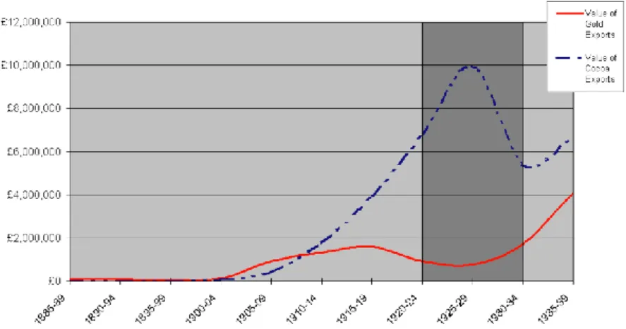
Gold mines, cocoa farms, and WWI 69
The impact of ex-servicemen in the aftermath of WWI 77
Economic vs. demographic change 86
Accumulation and individualism 87
vi
4. FROM DAKPEMA TO GULKPE-NA:INTRODUCING INDIRECT RULE TO URBAN
TAMALE 89
Introduction 89
Indirect rule and its ‘imposition’ in the Northern Territories 90
Duncan-Johnstone & Blair 96
Indirect rule in Tamale: From Dakpema to Gulkpe-Na 103
The politics and economics of an urban space under indirect rule 111
Natives and strangers 117
Conclusion 122
5. “THE WHOLE OF TAMALE WITHIN THE TOWN BOUNDARIES IS THE PROPERTY OF
THE CROWN”:URBANISM, LAND AND AUTHORITY 129
Introduction 129
Legislating land in the Northern Territories 130
Legislating land in Tamale 135
The redevelopment of Ward D 139
The politics of urban space in Tamale: The case of Ward D 145
Conclusion 153
6. NEW DEVELOPMENTALISM IN THE NORTHERN TERRITORIES:THE PLACE OF
TAMALE 155
Introduction 155
‘New developmentalism’ in the Northern Territories? 156
The organisation of labour and the Accra riots of 1948 161
Tamale and the war years 164
Ex-servicemen: Drivers of change in Tamale 168
Conclusion 181
7. A TOWN OF LITTLE IMPORTANCE 183
Introduction 183
A note on political configurations in the Northern Territories 184
Institutions, actors, and events: The emergence of traditional trajectories in northern politics 185
Establishing party politics in Tamale and Dagbon 203
Conclusion 216
8. CONCLUSION 217
Introduction 217
Relevance of the study 219
Theories of urban formation 222
Appendices 229
Bibliography 239
vii
Acknowledgments
Although I am the author of this book, it is the result of the direct and indirect efforts of many. Without those efforts, undoubtedly, this book would not have been possible. I wish to take this opportunity to express my profound gratitude to all those who contributed directly and indirectly to this book.
viii
simultaneously painful and extremely useful. I am also grateful to the NWO, whose four-year research grant made this study possible.
Moving from city to city, I have come to place great value on a sense of home. The completion of this PhD was possible only because in some of the places I have lived, I acquired a sense of home, even if it took some time. I am grateful to all those who have contributed to my sense of home.
I would like to thank Olivier van Maasdijk, Thomas Renouvin, Helge Dokters van Leeuwen, Jaap Langenberg and Maarten Engel for their friendship, especially when I first came to live in Amsterdam. In Leiden, I was given an office at the CNWS, whose absence serves as a great loss to the Leiden PhD circuit. I would like to thank especially Ilona Beumer, who helped integrate me in Leiden’s academic world.
The move from The Netherlands to Tamale in 2008 turned out to be a life-changing one. I would like to thank the people in Tamale who accepted me into their homes, shared their food, workplaces, networks, their worries, ambitions, aspirations, hopes, dreams, time, care and humour. I would like to thank especially Idrissou Andani and Alimatu Sadia Mohammed. My time in Tamale was made so much richer by you and your families. Idrissou, friend, I believe, absolutely, ‘come judgement day, you will collect your things’. Alima, the hardness of your life humbles me. I thank also Par Torstensson, who gave me a home in Tamale when I needed one, and whose old-fashioned friendship I treasure, and Martin Ingemansson, who inspired me with his disarming honestly. I am grateful also to the staff of the archives in Tamale, especially Mr Mahama, who tirelessly piled requested files on my desk.
ix
and Jan Binnendijk, who was tight with money, but generous with his visions on football. I would like especially to thank my fellow residents of ‘the PhD Room’ at the ASC; Margot Leegwater, Linda van de Kamp, Martin van Vliet, Fatima Diallo, Michiel van der Berg, Inge Butter and especially, Lotje de Vries, for her honesty, sense of perspective, humour, but mostly, her friendship.
I would like to thank also my family, my mom and dad, Katja and Robbert, who have always provided support. For a decade now we have lived 10 thousand kilometres apart, and yet, your presence is strong. And to my sisters, Heleen Soeters and Sacha Marais, whose love has never wavered. That my parents moved me to Cape Town in 1985 changed the trajectory of my life. I have not always found that trajectory easy to accept, and have often wondered if life might not have been easier had I not exchanged s’Hertogenbosch for Cape Town. But South Africa, with its terrible past, and its hopeful future, has taught me to value kindness above all else. In South Africa, I learned to love Africa. Africa is the fire I have always huddled around to give my life meaning. I have done so with my friends, Jeremy Stevens, Matthew Freemantle and Julia Grey.
xi
Preface
When the colonial administration founded its headquarters in Tamale in 1907, it was a small cluster of villages, containing together an estimated 1,435 residents.1 By the time the British flag was lowered outside the Chief Commissioner’s residence in Tamale in March 1957, Tamale had almost 48,000 residents; by a significant margin, the largest urban settlement in the Northern Territories of the Gold Coast. In the decades which followed Independence, Tamale’s population size would increase another 8 times to almost 400,000 today. According to Wyatt MacGaffey – the only other writer who has treated Tamale as distinct object of enquiry – Tamale is today the fastest-growing city in West Africa, although how this growth is measured probably has too-large an impact on the outcome. Nonetheless, Tamale during the colonial period and beyond as a site of profound change – social, economic, and political – can hardly be disputed. An outsider may ask: ‘Is it possible to write a
1
xii
comprehensive account of colonial administration in the Northern Territories of the Gold Coast without Tamale as a central actor?’
Is Tamale’s absence from the historiographical landscape of the Northern Territories not strange? Is, for instance, the bit-part role played by Tamale – the single largest economic and social transformation in northern Ghana during the colonial period – in Jeff Grischow’s book on ‘Civil Society’, ‘Community Development’ and ‘Development’ in the colonial northern Ghana, not peculiar, given the major themes of the book?2 According to the index, Tamale features nine times, all on separate, non-sequential pages. Perhaps it is more telling that in Staniland’s seminal text on the political change in Dagbon, Tamale is mentioned on 5 separate pages, and once, fairly substantially, in a footnote. In Ladouceur’s book on the politics of regionalism in northern Ghana, Tamale does not feature in the index although there are sporadic mentions of it, albeit very sparse. Carola Lentz gives Tamale slightly more attention. In her 346-page book on the making of history in northern Ghana, Tamale is mentioned on 21 separate pages. Like more contemporary texts on colonialism in northern Ghana, colonialism itself had an equally disinterested approach to Tamale. Within the history of northern Ghana, Tamale features as by-product of colonial administration, not an entity of colonialism in its own right. I do not believe that Tamale’s apparent lack of importance in both the colonial and academic fields is unrelated. Today, one senses a similar sentiment in the development sector: Tamale is a by-product of development rather than an entity of development in its own right. This thesis, generally speaking, hopes to insert Tamale’s historiography within that of the Northern Territories.
2
1
‘Tamale is more an administrative and
commercial centre within Dagomba
than a Dagomba town.’
1
Introduction
The opening paragraph of Staniland’s seminal text, ‘The Lions of Dagon’ reads: When the British moved their administration to Tamale in 1907, it was a village of 1,435 people. Now it is a sprawling town of 80,000, and the morning plane from Accra swings down to land over shimmering iron rooftops, concrete offices, and a web of asphalt roads, masts, and aerials.2
Despite Staniland’s multi-layered recognition Tamale, he hardly mentions Tamale in the remainder of the book. Tamale’s urban formation is in fact hardly mentioned at all in the otherwise rich historiography of the Northern Territories of the Gold
1
Staniland, M., The lions of Dagbon: Political change in Northern Ghana (Cambridge, 1975), 1.
2
Coast. This is peculiar given that, on the one hand, the impact of colonial rule is perhaps the dominant theme in the historiography of the Northern Territories, and on the other hand, Tamale is arguably the single most profound transformation of the colonial period in the Northern Territories. The kind of transformation that Tamale represented has been regarded as rather a non-issue both within academia trends, as well as within the colonial administration of the Northern Territories. One colonial official, referring to Meyer Fortes (who perhaps serves as the most prominent bridge between modern academia and the colonial administration, although he might have resented such a categorisation) wrote:
An anthropologist of unquestionable ability and some repute remarked to the writer how regrettable it was that the Talansi (sic) were becoming money conscious and generally criticised the efforts that are being made to develop trade in the Protectorate.3
The omission of Tamale’s urban formation from the historiographical landscape of the Northern Territories, however, says as much about the development of the academic study of the Northern Territories (and colonialism), as it does about Tamale itself. The title of this introductory chapter, a remark, almost in passing, also by Martin Staniland, goes some way to consolidate this fact; in 1960, three years after Ghana had attained its independence, Tamale’s population was still over 60 per cent Dagomba, down from over 70 per cent in 1948. The second single largest ‘ethnic’ group in 1960 were Ewe, with 4.5 per cent, followed by the Asante, with 3.6 per cent.4 Furthermore, Tamale’s ‘traditional’ political apparatus was, and is, dominated by Dagomba institutions. The Gulkpe-Na, the chief of the Gulkpeagu subdivision, is a Dagomba chief, as also is the Dakpema, another of Tamale’s chiefs.5 The Imam of Tamale’s Central Mosque is also a Dagomba. And yet, despite an overwhelming ethnic demographic majority, and a political structure which at least until 1957, defined Dagombas as ‘natives’ and all others as ‘strangers’, Tamale may still feasibly be regarded as an urban entity which is somehow not of Dagbon.
3
Public Records and Archives Administration Department (PRAAD), Tamale, NRG 8/3/49 ‘Annual Report for the Northern Territories, 1933-1934’.
4
Eades, J., Strangers and traders: Yoruba migrants, markets and the state in Northern Ghana, Edinburgh, 1993, 57.
5
Within this context, this thesis is fundamentally one about urban formation in Anglophone Africa during the colonial period. It is concerned with an urban settlement in the periphery, which came to exist directly due to, and for the purposes of, colonial administration. The thesis is concerned with how these specific characteristics relate to the dynamics of the urban formation itself.
Central arguments
Present-day Ghana is made up of a distinct north and south. The north stretches from the northern fringes of Asante’s cocoa-growing forest belt to the Burkina Faso border. Its landscape is generally of a savannah type, made up of shrub-bush dotted with shea trees. The north consists of three administrative units: The Northern Region, Upper East, and Upper West. They are, however, in a number of contexts often considered as a whole.6 The north’s economy is overwhelmingly agrarian and largely has a subsistence nature. The principle crops are yams, rice, sorghum, maize, shea, cassava, groundnuts, and cotton. The north possesses strong Muslim influences (except in isolated areas, that is Navrongo and Bolgatanga, where missions have had a strong influence),7 in contrast to the south, which is dominated by Christianity. Northern Ghana consists of a plethora of ethnically bound groupings, with diverse socio-political structures. The area is, however, politically dominated by five large centralised kingdoms, namely Dagbon, Mamprussi, Gonja, Wala, and Nunumba. In the years prior to its official inclusion in the British Empire in 1902, northern Ghana was referred to as the ‘Asante Hinterland’. In that year the area became recognised as the Northern Territories, a protectorate of the Gold Coast Colony. Since Independence, the area has been referred to as northern Ghana (containing the three aforementioned administrative units). Each of these titles reflects a different relationship vis-à-vis British colonialism, and for the remainder of this dissertation the employment of these terms is expressly linked to those differences. Tamale, the subject of this thesis, is the regional capital of northern Ghana. In 1907, when the British colonial administration moved its administrative
6
The Savannah Accelerated Development Authority (SADA) is perhaps the most recent example of this tendency.
7
headquarters from Gambaga to Tamale, Tamale consisted of a cluster of small villages,8 with a total population of around 1,435 residents.9 Today, a little over a hundred years after the founding of the administrative headquarters in 1907, Tamale’s population is somewhere around the 400,000 mark.10
The argument presented by this thesis is that Tamale’s political and socio-economic urban dynamic was informed profoundly by the cleavage between a colonially motivated, traditional political and administrative focus on the one hand, and an economic structure which relied almost entirely on the motorable road between Tamale and Kumasi, without any regard for traditional political centres such as Yendi, on the other. In this way, Tamale was a by-product of the colonial purpose. Although the nature of colonialism changed through the colonial period from pre-indirect rule, to indirect rule, to the second colonial occupation, all three colonial periods had one thing in common: Each strongly favoured the maintenance of African social structures as they were perceived by the British colonial administration. This thesis argues that the cleavage outlined above had the effect of firstly, disconnecting Tamale from traditional Dagbon structures, and secondly, creating a multitude of socio-political frameworks in Tamale which were regularly played off against each other in local disputes and claims, especially over land. More specifically, the thesis argues that:
1. Tamale was isolated, in that its economic centrality was not matched by any real traditional political significance within the politics of Dagbon. In other words, Tamale’s urban growth must be understood in the context of a d.isconnection between a colonial discourse that emphasised legitimate traditional authority on the one hand, and on the other hand, an economic and administrative spatial framework that ignored that authority.
2. The lack of traditional focus in Tamale, which itself was the result of the coincidence of Tamale’s lack of traditional importance coupled with its economic centrality, led to a local political structure in which many different
8 MacGaffey, W., ‘A history of Tamale, 1907-1957 and beyond’, Transactions of the Historical Society of Ghana, New Series, No. 10 (2006-7), 121.
9
Staniland, Lions, 1. 10
claims to authority could be, and often were, legitimated. Furthermore, Tamale’s political structure functioned in a climate of profound ebbs and flows in economic activity, the commercialisation of a number of key institutions, including land, and increasing ethnic and religious heterogeneity. This climate both increased the number of claims and raised the stakes further, which both placed enormous strain on Tamale’s ill-defined political structure and enhanced and consolidated its ill-definition.
1.1. Protecotrate of the Northern Territories, Ashanti Colony, and the
Cold Coast
Source: Chipp, T.F., 1923. The Gold Coast forestry problem. Empire Forestry Journal: 1-11.
Tamale’s urban development. Before doing so, however, it is useful to situate Tamale within cross-cutting themes in contemporary interpretations of northern history, not only to contextualise Tamale’s urban development, but also to contextualise the major thrust of this thesis and its contribution to the academic study of northern Ghana. To a considerable extent, the most dominant discourse within the study of northern Ghana is that relating to ‘underdevelopment’. Two inter-relating themes in particular are used to prop up this ‘agenda’, namely, north-to-south labour migration, and the Northern Territories railway that never was. The following subsection locates Tamale within those existing themes.
Tamale and the ‘underdevelopment’ narrative
The ‘underdevelopment’ narrative that underpins much of the historiography of the Northern Territories has its foundations within the colonial period. Seasonal hunger in the north created very early in the colonial period an imagination of ‘backwardness’ in the minds of the colonial administration.11 However, there is a
marked distinction between the perception of an existing backwardness and the active ‘underdevelopment’ and ‘neglect’ which came to dominate much of the northern historiography.
Northern ‘neglect’ arose as a point of serious dissatisfaction in colonial debates between ‘northern’ and ‘southern’ administrations, and it was later taken-up and extended by historians reflecting on regional relationships in Ghana generally. Carola Lentz notes that the talk of ‘neglect’ was ‘… adopted by the educated elite of the North, and Marxist-inspired authors (who) spoke not only of neglect, but of a deliberate policy of protracted “under-development”, pursued by the colonial government for the express purpose of sustaining in the North a reservoir of labour’.12
Indeed, works by N.J.K. Brukum,13 Nii-K. Plange14 and R. B. Benning15
11
Destombes, J., ‘From long-term patterns of seasonal hunger to changing experiences in everyday poverty: Northern Ghana c. 1930-2000’, Journal of African History, 47: 2(2006), 189.
12 Lentz, C., Ethnicity and the making of history in Northern Ghana, Edinburgh, 2006, 146. 13
sought to apportion blame for the north’s lack of development not to a lack of natural resources but to the colonial administration, and later, to southern-dominated governments. Ironically, there is a more or less straight line between such works and sentiments expressed by many early northern colonial administrators, especially those who had held northern posts before 1930. This thematic trajectory emphasised the impact on northern societies of north-to-south labour migration, especially to the mines, and the policies that encouraged it, particularly the decision not to build a railway. Interestingly, migration to the cocoa sector, which in terms of pure numbers was probably a larger and more sustained catchment of northern labour, has been less frequently incorporated into the ‘underdevelopment’ theme. There are some obvious reasons for this imbalance. The centralised nature of gold mining in terms of labour and labour recruitment makes it an easier study than, for instance, the cocoa sector. Sutton notes of the cocoa sector: ‘Labour … has come in ones and twos to work on farms of several acres … farmers probably employed more labour than the mines and other European enterprises, although because it was scattered it was less obvious a group than the concentrated labour force at the mines’.16 But
there was certainly also something less-coercive about the migration to cocoa farms than the migration to the mines. The case that this kind of migration (not directly coercive, and less centralised) made for the active ‘underdevelopment’ or ‘studied neglect’ of the Northern Territories was weaker than those where the emphasis lay on a centralised policy of labour recruitment, such as for the gold mines. Gold mines as a labour pool were legitimated as an object of enquiry also by what Lentz and Erlmann called the ‘workerist tendency’: Studies were inclined to focus on ‘those aspects of African labour, such as miners … that best seem to illustrate such a
14
Nii-K. Plange, ‘“Opportunity coast” and labour migration: A misinterpretation of proletarianisation in Northern Ghana’, Journal of Modern African Studies, 17: 4 (Dec. 1979), 655-76 and ‘Under-development in Northern Ghana: natural causes or colonial capitalism?’, Review of African Political Economy, 4: 15-16 (1979), 4-14.
15
Benning, R.B., ‘Colonial development policy in Northern Ghana, 1898-1950’, Bulletin of the Ghana Geographical Association, 17(1975), 65-79.
16
concept of an African working class’.17
In other words, in the gold mines in Tarkwa and Obuasi, leftist northern and southern historians seemed to find common ground and could engage in discussion about the development of the Ghanaian nation-state, which transcended regional histories.
Adjacent to the theme of the labour migration, at the core of the ‘underdevelopment’ theme is a discussion about transportation – more specifically, the Northern Territories Railway. This debate has been dominated by the argument that the colonial administration decided to ‘indefinitely postpone’ the building of a Northern Territories railway in order to secure a labour supply for the priority industries in the south. The main trend of this argument is that by the administration’s ensuring that transportation was prohibitively expensive in terms of northern farmers gaining access to southern markets, northerners were robbed of remunerative opportunities and were thus forced to head southwards to offer themselves as labour.18 This linkage between the decision not to pursue the construction of a Northern Territories Railway and purposeful underdevelopment in order to secure a labour supply for priority industries in the south, also has its roots in the colonial period. The District Commissioner for Eastern Dagomba wrote that,
The large number of labourers that go south each year will not in my opinion leave the Northern Territories as soon as they can obtain work and make money by growing food locally.19
Another Northern Administrator wrote that, ‘The movement of labour would diminish as soon as the demand for exports provided local employment with a remunerative return.’20 As transportation was generally regarded as the prohibiting
17 Lentz, C. & V. Erlmann, ‘A working class in formation? Crisis and strategies of survival among Dagara mine workers in Ghana’, Cahiers d’Etudes Africaines, 29: 113(1989), 70. 18 Bening, R.B., ‘Colonial’ development policy in Northern Ghana, 1898-1950’, Bulletin of
the Ghana Geographical Association, 17, (1975), 65-79 & N.J.K. Brukum, ‘Studied neglect or lack of resources? The socio-economic underdevelopment of Northern Ghana under British colonial rule’, Transactions of the Historical Society of Ghana (New Series), 2(1998), 117-31.
19
PRAAD, Accra, ADM 56/1/238. ‘District Commissioner for Eastern Dagomba, Government Railways, Reports on Railway from Kumasi to the Northern Territories’. 20
factor, such statements referred directly to the impact on labour of the decision not to construct a railway to the Northern Territories.
Where is Tamale situated within the ‘underdevelopment discussion? Chapter 3 of thesis argues that Tamale’s demographic growth spurts were positively correlated with surges in north-to-south labour migration, especially those related to migration to the cocoa farms. For instance, in the late-1920s, during the cocoa boom, the population growth of the Northern Territories, largely on account of out-migration, returned rapid year-on-year declines. Simultaneously, Tamale recorded its fastest demographic growth during the colonial period. Tamale’s demographic mechanism is thus negatively correlated to that of the Northern Territories more generally. The emphasis on ‘underdevelopment’ and the arguments which prop up this argument, coupled with the negative correlation between the drivers of Tamale’s urban growth and those of the Northern Territories more generally, has had the effect of writing Tamale out of the underdevelopment discourse, a dominant component of northern history.
Having outlined the major cross-cutting themes of northern Ghanaian historiography, we turn now to the four aforementioned frameworks within which this thesis situates Tamale’s urban transformation, namely (i) Dagbon political structures, (ii) colonial administration, especially in its influence over chieftaincy, (iii) north-south trade, and (iv) new developmentalism and the emergence of nationalist politics in northern Ghana. The following subsection discusses each of these historical narratives and how they relate to Tamale’s socio-political and urban development.
Frames of reference
Dagbon political structures
Tamale is located within the kingdom of Dagbon, perhaps politically the most powerful of the north’s ethnic groups. Dagon covers an area of 15,467 square kilometers and is divided into eight administrative districts. Its accounts for more than half of the total population of northern Ghana. Dagbon was established by conquerors from the north prior to the fifteenth century.21 Dagomba folklore relates the origins of Dagbo to Tohadzie, the Red Hunter, who hailed from the area that is today northern Nigeria. According to this version of Dagbon’s history, Tohadzie
settled within the Mali Empire somewhere between the thirteenth and fifteenth century. The village in which Tohadzie settled relied on a river for water, a river which had been taken over by a wild bush cow. According to the legend, the bush cow was believed to be an evil spirit who killed anyone who ventured to the river to draw water. Tohadzie led the villagers to kill the wild beast, making the river accessible. Tohadzie, by defending the village against attacks from rival villages, gained the reputation of a capable warrior and leader. Through his various military victories, he was able to marry Pagawugba, a princess from the area. Pagawugba
gave birth to a son, Kpongnambo. After the death of Tohadzie and Pagawugba,
Kpognambo travelled westwards from the Mali Empire to Biun in Fadan Grumah, where he became chief. Kpognambo ruled the kingdom of Biun until his death.
Kpognambo married two women: Sihisabiga and Suhuyini. Suhuyini gave birth to Gbewaah, and Sihisabiga gave birth to Malgimsim, Nyelgili, and Namzisheli. After the death of Kpognambo, there was constant war between his sons for the chieftainship of Biun. In response, Gbewaah and his followers migrated to Pusiga. Naa Gbewaah established the kingdom of Greater Dagbon, which he ruled until his death. Of the other sons of Kpognambo, Nyeligili founded the chieftainship of
Nangodi, and Namzisheli founded the chieftainship of Tongo. After the death of Naa Gbewaah, there was once again a power struggle among his sons, which led finally to the break-up of the Greater Dagbon kingdom. Tohagu founded the Mamprussi
21
Kingdom, Mantambo the Nanun Kingdom, and Sitobu the modern Dagbon Kingdom. With superior military organisation, sons and grandsons of Sitobu expanded the modern Dagbon kingdom, destroying existing hierarchies and installing their own kin as chiefs. In time, Yendi, a former Konkomba settlement called Chare,22 was established as the seat of the paramount of the modern Dagomba kingdom, and the paramount was entitled the Ya Na.
Contemporary references to Dagbon political structures point to the political crisis which reached its zenith with the murder of the Ya Na Andani II in March 2002. The crisis itself however predates the formation of modern Ghana. In the period 1824-1849 the primogenital tradition of unilateral family succession to the Ya-Na Skin was changed to an alternation of succession between the Abudu and Andani families.23 These family lineages are referred to as ‘gates. This ‘alteration system’ was introduced to incorporate the male descendants of Ya Na Yakubu I’s two wives.24 Ya Na Yakubu I’s two sons, Princes Abudu and Andani, rebelled against their fatherThe princes prevailed in the war but spared the life of their father and allowed him to remain Ya Na until his death. Princes Abudu and Andani upon their victory seized and ascended the royal skin, or kingship, of Mion and Savulgu skins, respectively. After the death of Ya Na Yakubu I, the kingmakers of Dagbon decided on Mion Lana, Prince Abudu, as the successor to Ya Na. The system of alteration between gates was complicated by polygamy, and complicated succession protocols, and forms the root cause of the current Dagbon crisis. The system was further complicated by a number of colonial interventions. The relevancy of Dagbon’s ‘gates’ to Tamale is discussed in Chapter 7.
Tamale is located about 95 km to the west of Yendi. There are many versions of this tale. Although Tamale possesses a number of Dagomba local shrines, Ta’ha, whose earth priest is the Bugulana, is perhaps the only one of Tamale’s traditional assets
22
Staniland, Lions, 5. 23
West Africa Civil Society Institute (WACSI), ‘Governance and security in Ghana: The Dagbon chieftaincy crisis’, 2011, 10.
http://www.wacsi.org/images/public2/b32n865uDagbon%20Crisis%20Report%20WACSI.pd f Accessed 02-10-2011.
that relates to Dagbon more broadly. A.W. Cardinall, who became District Commissioner (DC) for Yendi in 1917 and later Superintendent for Education, notes that the Ta’ha was apparently visited not only by local people ‘but by Dagomba from all over the country’.25 But generally speaking, drummers tend to relate Tamale
to the larger Dagbon history only if or when prompted, and the ways in which Tamale’s political structures may be incorporated into Dagbon are often unconvincing. Put bluntly, despite Tamale’s current significance, its role in Dagbon political history is not particularly prominent.
The same is true for Dagomba economic history. In most traditional historiographies, it is of course very difficult to separate the distribution of political authority and the distribution of economic activity. In terms of northern Ghana, this relates especially to trade routes.
According to Ferguson and Wilks, in the century prior to the start of the Asante Wars in 1821, the Dagbon political structure was well developed and relatively robust.26 However, the defeat of Asante in 1874 had implications far beyond Asante itself. Since Asante had defeated Dagbon in 1744/5, Dagbon had served as peripheral of Greater Asante. For Kumasi, because Yendi lay on an important trade route between Salaga and Hausaland, political stability in Yendi was a priority for Asante royal elites. As a result, in the late eighteenth century the Ya Na’s armies were modernised with the assistance of the Asante. Kambonse, Asante musketeers, were included in the Ya Na’s army for the first time. The relationship between Asante and the Yendi certainly strengthened and centralized the authority of the Ya Na. The centripetal effect that Asante domination had on Dagbon political structures had a cost: Dagbon paid (with some resentment) an annual fee to the Asantehene in the form of slaves. When the British first launched attacks on the Asante in the 1820s and 1830s, the Gonja, who like Dagbon paid an annual fee to the Asantehene in recognition of his authority, revolted, killing a number of Asante officials in
25 Cardinall, A.W., Tales in Togoland. Oxford: University Press, 1931, 68. 26
Salaga. The result was that Asante royalty redirected trade away from Salaga, through Kintampo. Wilks notes:
The early nineteenth century Ashanti, then in command of almost all of what is now Ghana and the eastern Ivory Coast, deliberately re-routed its trade away from the north-west and to the north-east, through Salaga, Yendi, and Sansanne-Mango to the Bussa crossing of the Niger.27
Both Gonja and Dagbon political centres suffered dramatically as a result of being starved of Asante trade. Dagbon central authority declined dramatically after the fall of Asante, either because Yendi’s commercial significance severely declined, or because without the support of Asante, Dagbon political structures lost much of their strength. Ferguson and Wilks note that, ‘(t)he collapse of Ashanti control over northern Ghana appears to have presaged a period of considerable chaos in Dagbon’.28
In the period after the final defeat of the Asante between 1874 and the arrival of the British at around the turn of century, Yendi lost much of its authority over much of Dagbon.
In contrast to Yendi, Tamale’s position in the Asante trade was not prominent. K. B. Dickson states that Tamale lay on a major trade route.29 MaGaffey notes that ‘a map of the north in 1887 showed Tamale market as the destination of cattle trails from Kumbungu, Savelugu and Daboya’.30 The pre-European commercial importance of
Tamale must be related, however, to the size of its population (1,435), which suggests that Tamale’s centrality in terms of trade may be overstated. Paul Lovejoy has noted three north-south trade routes, none of which pass through Tamale.31 Furthermore, a number of maps of the north produced around the turn of the twentieth century do not include Tamale (see Map 1.2). Thus, not only did Tamale
27
Wilks, I., ‘The Northern factor in Ashanti history: Begho and the Mande’, Journal of African History, 2: 1(1961), 340-1.
28
Ferguson, P. & I. Wilks, Chiefs, ‘constitutions and the British in Northern Ghana’. In: Crowder, M. & O. Ikime, eds, West African chiefs: Their changing status under colonial rule and independence. New York, 1970, 343.
29
Dickson, K.B., A Historical geography of Ghana. Cambridge University Press, UK., 1969, 264
30 MacGaffey, W., ‘A history of Tamale, 1907-1957 and beyond’, Transactions of the Historical Society of Ghana, New Series, No. 10 (2006-7), 121.
31
Lovejoy, P.E., ‘Polanyi’s “Ports of Trade”, Salaga and Kano in the Nineteenth Century’,
lack traditional political status before the arrival of the British colonial administration in 1907; it was also not a significant economic focal point in terms of Dagbon’s political and economic systems.
Tamale thus entered the colonial period without any real significance in terms of Dagbon more generally. It was, indeed, colonialism itself that gave Tamale its significance, even if it did so reluctantly. That being said, that Tamale was not a significant Dagbon centre did not mean that it was unaffected by changes taking place, also on account of colonialism, within broader Dagbon traditional structures. As a result, Dagbon’s political and economic structures form the first frame of reference for this thesis.
Colonial chieftainship and its implications for Tamale
The colonial annexation of the Asante Hinterland began slowly after the defeat of Asante in 1874. Very little was known about Dagbon before about 1880. Some Europeans had created accounts based on reports from local travellers. Ludwig Ferdinand Romer, who based his account of Dagbon on Ga informants from Accra who had travelled to the north, was the first to describe Dagbon. Romer himself had never been to Asante, never mind its ‘hinterland’.32
Later, Bowditch reported on Dagbon, based on information from Muslims resident in Kumasi. In 1881 Lonsdale visited Yendi and was perhaps the first European to report on Dagbon, having actually been there.33
Before long, a ‘scramble’ between German, French, and British interests threatened to erupt, putting increasing pressure on each of the European powers to stake their claim. But competition from other European powers was not the only threat faced by Britain in the annexation of the Asante Hinterland. In fact, the British were fundamentally faced with three threats in annexing the Asante Hinterland. The first was the threat from outside powers, namely from competing European powers and
32
Weiss, H., ‘European images of Islam in the Northern hinterlands of the Gold Coast through the Early colonial period’, Sudanic Africa, 12(2001), 95.
33
from forces of the Mandingo warrior, Samory, which were invading the region. Second was the threat from local actors assimilated to the invasions of Samory, such as Babatu, a Songhai horseman. Third, as Jack Goody puts it, ‘there were struggles
between … the tribal peoples, continual eruptions of violence in attempts to settle scores by feud or by threat of feud.’34
In terms of threats from European powers, the British feared that if French or German interests came to occupy the Asante Hinterland, the Gold Coast would be dependent on those European powers for important components of its food supply, perhaps most notably meat, which was supplied primarily by long-haul trades from the Niger Bend.35 Martin Staniland notes that the Northern Territories was annexed by the British ‘… not because of any intrinsic value they possessed, but because it was strategically undesirable to let the French or the Germans take them … ’.36
From 1874, after the defeat of Asante, British, French, and German explorers increasingly began to map the area north of Asante, threatening transit trade down to the British-controlled coast.37 The British sent Gouldsbury north in 1876, and in 1892 George Ekem Ferguson went north on behalf of the British colonial administration. In the same year as Gouldsbury’s expedition in 1876, M.J. Bonnat, a French trader, came up the Volta to Salaga, and in 1888 the French explorer Louis-Gustave Binger passed through Mamprussi, Karaga, Salaga, and Kintampo on his way from Bamako to the coast. The Germans were represented in 1886 by G.A. Krause, who travelled from Accra to Ouagadougou, and in 1888 Curt von François visited Yendi and Gambaga. The increased competition for influence in the West African savannah led to the establishment of a Neutral Zone in 1888, in which it was agreed that no European authorities would initiate the signing of trade treaties with chiefs. Salaga, Yendi, and Tamale all lay within the Neutral Zone. In 1895, Britain and Germany tried, but failed, to agree on a solution by which Yendi would fall
34
Goody, J., ‘Establishing control: Violence along the Black Volta at the beginning of colonial rule’, Cahiers d’Etudes Africaines, 38: 150/152(1998), 227-8.
35
This proved indeed to be the case during WWII, when, on coming to power, the Vichy government closed the Northern border, creating a crisis in the livestock sector.
36
Staniland, Lions, 39. 37
under German jurisdiction and Salaga under British administration. A year later in 1896, a German explorer, von Carnap-Quernheimb, passed directly across the Neutral Zone, inciting protests from London and increasing the instability of the Neutral Zone. In that same year, the Neutral Zone was abandoned.38
Another serious threat to British domination of the Asante Hinterland were the forces of Samory, the Mandingo warrior. In September 1895, Samory’s forces attacked Wa, Sankana (in Dagarti), and Bole (Gonja). What was of concern to the British colonial administration was not only the destruction and instability which Samory and his forces were causing in large swaths of the Asante Hinterland, but also the possibility of Samory linking up with either French or German troops.39 Finally, after a rather long run-up, the occupation of the area by German, French, and British interests was effectively settled in a rush during the final days of 1896. The occupation of the Asante Hinterland has been described by Martin Staniland: The partition finally took place in a rush at the end of 1896, with British, French, and German expeditions converging on the neutral zone in the last weeks of December. The German force, under Grunner and von Massow, moved up from Kete-Kratchi, defeated the Dagomba at Adibo, and then went on to occupy Sansanne-Mango before a French mission could get there. The French arrived too late, on Christmas Day. But when a German detachment moved on Gambaga, they in turn found that a British expedition under Captain Stewart had arrived before them. The French withdrew to the east, while Stewart entertained the German commander over Christmas.40
The borders between French, German, and British troops stabilized relatively quickly. In 1902 the Anglo-German border was finally formalised.41 It was to run along the Daka River, to the ninth parallel, and thereafter to pass northwards through
38
Staniland, Lions, 10. 39
Goody, J., ‘Establishing control: Violence along the Black Volta at the beginning of colonial rule’, Cahiers d’Etudes Africaines, 38: 150/152(1998), 227-8.
40
Staniland, Lions, 10. 41
a point twenty kilometres west of the centre of Yendi.42 Four years previously, in 1898, Samory had been captured by the French administration, further stabilising the area.
The Anglo-German border bisected Dagbon such that Yendi, the seat of the Ya Na, the paramount chief of Dagbon, fell within German territory, whilst second-tier chiefs of Mion, Karaga, and Savelugu all fell under British jurisdiction.
1.2. German Togoland and its protectorates, 1897 (showing ‘Jendi’)
Source: Geographischer Monatsbericht. In: Dr. A. Petermann‘s Mitteilungen aus Justus Perthes Geographischer Anstalt (Gotha), 43 (11), 1897, p.270f.
42
The splitting of Dagbon into Western (British) and Eastern (German) components was not considered especially problematic by the colonial administration. Even the Ya Na himself could not convince the British to take an interest in negotiating the position of the Anglo-German border such that Yendi would remain united with Dagbon. The Ya Na had written to the British authorities as early as 1898 stating that, ‘I am King of Yendi … I want to be English not German … I am king of Yendi for the English not the Germans. I trust in God and the English’.43 Although archival
sources suggest a number of sensitivities in terms of the location of the border, the fact that Yendi was excluded from British Dagbon does not appear to be amongst them. Colonel Morris, a veteran of northern military operations, declared famously to an assembly of Dagomba chiefs that, ‘ ... since the Ya-Na was now in German Territory, he (Colonel Morris) and not the Ya-Na was henceforth their Head Chief’.44 The division of Dagbon, such that the authority of the Ya Na was excluded
from much of Dagbon, including that part containing Tamale, created a significant political upheaval also in British Dagbon. Various chiefs in Western Dagbon took advantage of the Ya Na’s absence and advanced their chiefdoms. Tamale, along with Mion, Karaga, and Savelugu, found itself on the British side of the Anglo-German border, isolated from the authority of Yendi, and it is to this that we now turn.
For Tamale, the re-unification of Dagbon in 1922 was as significant as its division between British and German jurisdictions in 1902. Indeed, the reunification of Dagbon and the re-introduction of the Ya Na at the apex of Dagbon authority largely shaped Tamale’s internal politics. During the period in which Dagbon was divided, the Dakpema, which translates as ‘head of the market’, had established himself as the chief of Tamale.45 He managed to do so by gaining the sanction of the colonial administration. In 1919, following the end of World War I (WWI), when the Anglo-German border was on the verge of collapse, the colonial administration began talks
43
Public Records Office (PRO), Kew, CO. 879/52, African (West) 549, p. 110: Dispatch by Capt Kenny-Herbert, encl., Translation of letter from Ya Na, Jan. 6th, 1898.
44
Staniland, Lions, 57, quoting Major Morris. 45
with the Ya Na to negotiate his return to the British Dagbon political fold. One of his first demands was that, on the grounds that the Dakpema was not the legitimate chief of Tamale, the Dakpema be replaced by the ‘rightful’ chief of Tamale, the Gulkpe-Na. His claim was that at the moment at which the Anglo-German boundary was established, the Gulkpe-Na was visiting Yendi and was ordered to remain there. In that time, the Dakpema presented himself as the chief of Tamale and, being uncontested, received the backing of the colonial administration. The colonial administration agreed that upon the death of the Dakpema, his successor would receive reduced powers, and the Gulkpe-Na would be reinstalled as the chief of Gulkpeagu. In 1930, when the Dakpema suffered a stroke, the colonial administration moved to reinstate the Gulkpe-Na in Tamale. It is hardly surprising that those within the Dakpema’s house sought to prevent the reintroduction of the Gulkpe-Na. The British operation was deemed a success, and given the introduction of indirect rule around the same period, deemed utterly necessary for the successful administration of Tamale. However, the result was a traditional system in Tamale continually plagued by confusion over the authority and legitimacy of the Gulkpe-Na and the Dakpema. Whilst the Gulkpe-Gulkpe-Na had the authority of Yendi and the colonial administration behind him, the Dakpema had strong local support. This tension was a hallmark of Tamale’s local politics both during the colonial period and beyond.
Chieftaincy was central in all forms of colonial administration, both before and after indirect rule, and, as Grischow notes, also under the new developmentalism (see Chapter 6). Instructions given to officers in charge of northern districts in 1899 noted that ‘… officers will act through the native chiefs as far as possible … ’.46 In 1906, Acting Governor H. Bryan echoed existing northern administrative sentiments when he wrote to the Secretary of State that ‘(t)he policy of supporting and emphasising the position of the paramount native chiefs while, at the same time, making them realise their responsibility, appears to me to be the only practicable
46
system of administering this country’.47
Furthermore, in the annual report for 1906, it was noted that moving the headquarters to Tamale was favourable as it lay within Dagbon, and ‘Dagomba country is the most advanced from a civilised point of view in the whole protectorate’.48 The perceived strength and functioning of organisation
of the Dagomba traditional political system fed into the use of chiefs as auxiliaries of colonial administration. It was felt that in such instances where chiefs had managed to retain some semblance of pre-European significance, they served as a more effective colonial tool, in contrast to those chiefs amongst peoples where traditional systems had lost much of their legitimacy. This also allowed for a ‘thinner’ British administration. Colonial chieftaincy thus provides the second important frame of reference for this thesis. Colonial chieftaincy was not static and certainly changed through the colonial period.
Commerce and Tamale
The British annexed the Asante Hinterland largely for the purposes of securing north-south trade to and from the British-controlled coast. Trade was thus central to colonial policy in the north even prior to the formal annexation of the ‘Asante Hinterland’. George Ekem Ferguson, an explorer from the coastal town of Anomabo, was sent to the north by the British in 1892 with a mandate to negotiate ‘treaties of friendship and freedom of trade’ between the Crown and the leaders of indigenous polities’.49 Chalfin notes that Ferguson’s ‘sights were set on a central
object: The unobstructed movement of goods in and out of the savannah zone’.50
The Asante Hinterland was not believed to possess any significant economic potential beyond the trade that passed through it. Staniland notes that ‘… the NT had very few of the assets which had made colonialism elsewhere such an uplifting and profitable enterprise’.51
This is supported also by Sutton, who notes that ‘… the Northern Territories was acquired belatedly, and added almost as an afterthought to
47
PRO, Kew, CO 98/14 Letter by Ag Governor Bryan to Secretary of State, 13th July, 1906. 48
PRO, Kew, CO 96/16. (Report on the Transport Department for the Year 1906).
49 Chalfin, B., Shea butter republic: State power, global markets, and the making of an indigenous commodity. Routledge, 2004, 96.
50
Chalfin, Shea, 96. 51
the Gold Coast Colony’.52
But the Asante Hinterland was annexed by the British colonial administration owing to the transit trade which passed through it en route to and from the coast. Brenda Chalfin notes that the colonial administration harboured ambitions to establish a ‘massive trade corridor where Britain was the sole imperial power’. 53 The corridor was to run several hundred miles north from the boundary of
the Gold Coast into Mossi territory and east through the jurisdiction of the Niger Company.54 The strongest statement in this direction was the abolishment of the caravan tax in 1908. The southern administration felt that the tax on caravans passing north-south was hindering the volume of trade down to the coast. As a result of the abolishment of the caravan tax, the northern colonial administration was left without any revenue, which was believed, especially by southern administrators, to be inconsequential: Revenue for development was not important as long as there was nothing to develop.
Tamale’s demographic and economic prominence may be reduced to two developments. The first was the decision by the colonial administration to establish a colonial headquarters at Tamale, and the second was the uptake of motorised transportation by local and ‘Syrian’55
entrepreneurs, following the completion of the Great North Road in 1920. The argument is not so much if one or both of these developments provided the catalyst for Tamale’s demographic growth and economic centrality, but how the two related to one another in order to produce Tamale’s urban growth. The demographic pull that the administrative headquarters alone provided was limited. Monies to build the new headquarters pulled some labour towards Tamale. The chiefs were encouraged to provide labour for the construction of the new headquarters at Tamale, in return for gifts proportionate to the amount of labour provided. The cost of building the headquarters was estimated at £8,935, but
52
Sutton, I. ‘Colonial agricultural policy: The non-development of the Northern Territories of the Gold Coast’, The International Journal of African Historical Studies, 22: 4(1989), 637.
53
Chalfin, Shea, 95. 54
Chalfin, Shea, 95. 55
two years later the cost had risen to £15,000.56 The demographic impact of this financial focus was significant but not defining. Tamale grew from 1,435 residents in 1907 to 3,901 in 1921. Although this growth is certainly significant, Tamale did not grow much faster than settlements such as Savelugu. In 1921, Navrongo, where a provincial and headquarters was based, had a population of 14,798, whilst Bawku also had a much larger population than Tamale in 1921, with 7,710 residents.57 However, that the colonial headquarters were built in Tamale meant that in 1920, the Great North Road was built between Kumasi and Tamale and not elsewhere in the Northern Territories. From the moment the Great North Road was completed, it was the local commercial energies that prompted Tamale’s economic and demographic growth.
The introduction of motorised transportation provided a huge impetus for trade and traffic between Tamale and Kumasi. As Kumasi was linked by rail to the coast, northern producers were able to access new demands at the coast. Furthermore, the road, being the only motorable road that connected the north and the south, monopolised the route through Tamale, and as a result, Tamale flourished. The increase in trade passing through Tamale on account of the adoption of the lorry created new, non-agrarian remunerative opportunities in the Northern Territories. The number of petty traders in Tamale boomed, as also did markets in car parts, auto-related services, oil, and petrol. The increase in lorry traffic is an indication of the increase in trade and human traffic which passed through Tamale. In 1927, only seven years after the Great North Road was completed, 4,420 lorries crossed the Volta River at Yeji in both directions, 2,462 of them with trailers.58 Tamale’s population grew correspondingly. In 1921 Tamale had a little under 4,000 residents, not significantly bigger than several other northern settlements. In 1931, eleven years after the Great North Road had been completed, Tamale’s population was 12,901.59 During this period, Tamale grew faster than both Kumasi and Accra. By 1948, Tamale’s population had grown to 16,055, and in 1960 it was around
56 MacGaffey, ‘History’, 110. 57
The Gold Coast Handbook, 1928. 58
PRAAD, Accra, ADM 56/1/310 (Yeji Ferry Trade Statistics). 59
48,000.60 In economic terms, Tamale became increasingly connected to southern demands and supplies. Syrian traders set up stores, retailing consumer goods such as sugar, soap, bicycle tyres, and flour. In the 1930s and 1940s large foreign-owned trading firms began to take interest in Tamale’s markets. Yoruba traders settled in Tamale and bicycled United Africa Company (UAC) goods to rural markets.61 The amount of beer taken northwards increased from zero in 1925 to a little less than 1,400 cases in 1929.62 Livestock, especially sheep, goats, and chickens, were taken southwards on lorries, as also were agricultural surpluses such as shea butter, bundles of corn, and groundnuts.63 These kinds of local economic activities where not perceived by the colonial administration to add value in the way an export crop would. As a result, they were relatively ignored, at least until after 1945.
Both literally and figuratively, Tamale was linked to its Great North Road. Tamale’s population grew as trade volumes grew, and Tamale’s growth declined when, as during World War II (WWII), the volume of motorised trade declined. This statement must be understood, however, in the context of the Northern Railway which was never built. The railway (the lack thereof) in turn was (and still is) the ultimate symbol of northern underdevelopment at the south. It coloured colonial sentiment, and the motorised transport driving Tamale’s urban expansion was never regarded as a successful colonial economy. Despite the pervasiveness of a sense of commercial failure, trade statistics kept at the ferry crossing at Yeji tell a much different story, a story in which Tamale’s urban transformation is perhaps the protagonist. Motorised trade forms the bedrock of Tamale’s demographic and economic growth.
“New Developmentalism” and the rise of party politics in Tamale.
The end of WWII saw a great change in the method and purpose of colonial administration. Indirect rule was replaced by local government structures in order to absorb African intelligentsia, who might be tempted to engage in growing
60 Population Census of Ghana 1960. 61
Eades, Strangers, 112. 62
PRAAD, Accra, ADM 56/1/310 (Yeji Ferry Trade Statistics). 63
colonial nationalist movements, into a local political structure in which they would work alongside chiefs. Furthermore, land planning and mechanisation replaced mixed farming. However, Grischow argues, in contrast to Cooper, that unlike the development ideology set forward by Chamberlain around the turn of twentieth century, the new developmentalism was intended to ensure large-scale economic development without decimating existing African social structures. 64 In this sense, the Northern Territories, on account of having large tracts of uncontested land, which in any case was vested in the Crown, and only a small African intelligentsia to absorb, was seen as an ideal playing field for the new developmentalism. This framework, however, wholly excluded Tamale, as Tamale’s social fabric, largely on account of the resettlement of ex-servicemen in Tamale, was undergoing profound urban processes. The contradiction between the aims of the post-war new developmentalism and Tamale’s urbanising process worked to further isolate Tamale from the north more generally, a major theme of this dissertation.
It was in this context that party politics entered the north. Nationalist politics came relatively late to the Northern Territories, and the inclusion of the north in the political forces which led finally to independence was not unproblematic. An important starting point for a discussion about nationalist politics in the Northern Territories is that the north’s original inclusion in the state apparatus in the south was orchestrated by colonial intervention and conducted within the colonial vision. That meant primarily that chiefs and/or those aligned with chieftaincy were given the lead in integrating the north into nationalist politics. This was done through the creation in 1945 of the Northern Territories Council (NTC). Later, in 1953, in the run-up to the 1954 elections, the leadership of the NTC formed the Northern Peoples Party (NPP), to run as a northern interest group in the upcoming elections. The rivalry between a tradition-laden, conservative NPP and a southern dominated, progressive Convention People’s Party (CPP) forms the most significant political dichotomy of the nationalist political narrative of the Northern Territories. Although other political actors feature in the narrative, such as the Muslim Association Party
64
(MAP), they broadly align to one or other side of the dichotomy. Although the staunchly conservative MAP won the Tamale constituency in 1954, in the 1956 election, the CPP recorded a resounding victory. The manner in which the CPP worked to win over Tamale’s electorate, especially through (mis)use of the Tamale Urban Council, is an interesting feature of Chapter 7. Equally important for this thesis was the alignment of traditional actors in Tamale, such as the Gulkpe-Na and the Dakpema, especially in relation to the positioning of the Ya Na in Yendi, and how such alignments affected Tamale’s internal socio-political dynamic. The introduction of party politics to Tamale not only shaped Tamale’s socio-economic and socio-political fabric going into the post-colonial period; it also reveals Tamale’s position within the Northern Territories more generally. It provides the fourth and final of the frames of reference in which this thesis situates Tamale’s urban development.
Theoretical frameworks
There are a number of theoretical perspectives that need to be unpacked in this introductory chapter. The theoretical frameworks employed in this dissertation relate to why cities come to exist, how they are sustained, and how the forces which prompted a city’s creation relate to the socio-economic and socio-political landscape within the city. Throughout the thesis, these theoretical perspectives are related to Tamale as a colonial city.
Economic considerations
suggest that the location of cities is a rational economic outcome, the NEG models suggest that urban development is rather characterized by path dependence, whereby historical accidents may have long-term cumulative consequences. In terms of Tamale, this encapsulates both its colonial underpinnings and its continued existence (expansion) during the post-colonial period.
NEG makes a strong argument for why cities grow. In short, market-size effects (such as economies of scale) make it desirable for firms to locate close to one another, which simultaneously has the effect of increasing wages, and thus pulling labour. Once the process of agglomeration has started, it continues because, up to a point, the larger the city, the more beneficial it is for firms to locate there (cumulative causation). However, after ‘that point’, it is no longer beneficial for firms to move to the city. This is determined by centrifugal forces, which include land rents and immobile factors, such as natural resources and congestion. For instance, once land rents and/or congestion outweigh the benefits of market-size effects, firms will no longer locate to that agglomeration. As in Von Thunen’s work, transportation is another fundamental component of the NEG models. High transport costs result in less trade. In such instances, regions65 will be isolated and differ little from each other. Workers and firms will be evenly divided across regions. However, a drop in transport costs changes the distribution of both firms and workers across regions.66 Transportation is thus a critical variable of city growth within the NEG models. Despite its strong colonial origins, Tamale’s existence beyond the colonial period, as is the case with most colonial cities, is theoretically explained in this way. NEG is, however, subjected persistently to two primary criticisms. The first is that it lacks the tools to cater effectively for empirical application of its models.67 The second persistent criticism, perhaps more relevant to this thesis, is that although NEG models may well explain why firms locate to existing cities, the models have
65
The word ‘region’ refers to any spatial entity – communities, localities, towns, cities, conurbations, etc.
66 Krugman, P., ‘What's new about the new economic geography?’, Oxford Review of Economic Policy 14: 2(1998), 7-17.
67
Martin, R., ‘The new geographical turn in economics: Some critical reflections’,