A NOVEL KEYWORD COVER SEARCH USING APRIORI ALGORITHM
SIRMARIGARI SHIVANANDAM1, DR M SREENIVASA RAO2& DR. G VENKATA RAMI REDDY3
1
M-Tech Dept of CSE School of Information Technology, JNTU Hyderabad, TS, INDIA, Mail id: - [email protected]
2
Professor Dept of CSE School of Information Technology, JNTU Hyderabad, TS, INDIA, Mail id: [email protected]
3
Associate Professor Dept of CSE School of Information Technology, JNTU Hyderabad, TS, INDIA,
and Mail id: - [email protected]
Abstract
Information in spatial information bases are associated with spatial coordinates. Text pertinency and
spatial proximity are considered for retrieval. It is mundane that the objects in a spatial information base
(e.g., hotels/restaurants/parks) are associated with keyword(s) to represent their
businesses/accommodations/features. Recent works on spatial information is predicated on a set of
objects. An approach is to retrieve m most proximate objects gratifying certain utilizer designated
conditions. Most proximate keyword search (Keyword cover search) is to query objects, which together
cover a set of query keywords and the inter-objects distance is minimum. In which keyword rating given
by different users is additionally considered. A formidable number of spatial indicators have been aimed
to help spatial information retrieval. In keyword cover search user’s current location is not designated.
Location vigilant most proximate keyword search in spatial information can surmount this quandary by
providing user’s current location as input and provide a path to such a location. Travelling distance is
considered to engender a path, rather than Euclidean distance. Additionally the results retrieved in
keyword cover search may not be always desirable to user’s cull. This critical drawback can be
overcome by most proximate keyword search predicated on current location of utilizer.
Keywords:Spatial information base, point of interests, keywords, keyword rating, keyword cover.
1.
Introduction
One of the most paramount kinds of queries in
spatial information bases is location-predicated.
Location predicated accommodations are mainly
applied for most proximate Neighbors query.
Given a particular location, and a set of points
of intrigues, e.g. hotels, temples, parks etc., the
most proximate Neighbor query returns the
points of interest most proximate to the query
point. Due to location-predicated
accommodations and the availability of
extensive digital maps plus satellite imagination
(e.g., Google Maps), ye spatial keywords search
quandary has gained much attention recently.
Sundry information mining methods are applied
astronomically immense spatial information
bases.
A. Keyword search in spatial
information
Spatial objects are associated with geo-location
and a text description. Spatial keyword search is
performed on spatial information. Keyword
search is performed by applying queries on
spatial information. In order to make
expeditious retrieval sundry indexing methods
are applied. Techniques that enable the indexing
of information contains both text descriptions
plus geo-locations which changes effective
processing of spatial keyword queries that
assume a geo-location plus a set of words as
input and return pertinent content that matches
the keywords. Spatial keyword queries are being
fortified in authentic-life applications like
Google Maps where points of interest can be
retrieved. Spatial keyword search mainly
conducts with textual information and spatial
information . Spatial information includes our
points of concern like hotels, restaurants, parks
etc. And the keywords cognate to these objects
are considered as textual information. Mainly
there are two types of spatial keyword querying.
Single object oriented
Object set oriented
Single object oriented queries are predicated on
the retrieval of a single type of object. Utilizer
gives a single type of object and the retrieved
result are predicated on user’s location or given
descriptions about keyword. Single object
oriented includes following types of queries.
kNN Query: recover the k objects closest
to the user’s current location
(represented by a point).
Top-k nearest neighbor Query: Top k
objects with the highest ranking scores
are retrieved, assessed as a compounding
text verbal description to the query
keywords and distance to the query
location (a point).
Range Query: Objects whose text verbal
description contains userassigned
keywords plus location is amongst a
range specified by the user is retrieved.
A number of geo-textual indices are being.
These indicators combine a spatial index and
atext index structure.
Object set oriented is based on retrieval of group
of different types of objects. m Closest Keyword
(mCK), closest neighbor search and keyword
cover search plus corporate spatial keyword
query are admitted under this category. It
includes retrieval of multiple types of objects
satisfying certain query keywords.
m Closest Keyword query: Retrieves m
closest objects which can cover all the
query keywords.
Collective spatial keyword query: recalls
collection of objectives in a particular
location. User’s location and keywords
The existing indices include R-Tree based
indices, grid grounded indicators, space filling
curve based indices etc. Along on the R-Tree
established spatial indexing following text
indexing can be used. Text indices are reversed
file based, bitmap established and key signature
file founded indices. In addition, some of the
powers roughly combine a spatial and a text
index while other indices resulting in hybrid
index structures by tightly combining them.
B. Indexing methods
The main purport of storing an index is to
ameliorate performance and speed in finding
pertinent documents for a search query.
Indexing enables expeditious retrieval of
information . Signature files are word-oriented
index structures and are predicated on hashing.
And it is not felicitous for profoundly and
astronomically immense texts. An inverted file
is a word-oriented mechanism which sanctions
indexing a text amassment in order to expedite
the probing task. In hybrid indexing method all
these information are augmented along with the
nodes of a tree. Spatial information indexing
methods are as follows.
R-Tree
R*-Treespacial
Hybrid indexing methods combines the spatial
and textual indexing plus thus furnishes
effective pruning power to the searching
method.
C. R-Tree and R*-Tree
An R-Tree is akin to B-Tree and it is
height-balanced [9]. B-Tree is a self-balancing
information structure; information are sorted
and can be utilized for searches, sequential
access, insertions, and effacements in
logarithmic time. It is is a generalized form of
binary search tree in which a node can have
more than two children. R-Tree is composed by
aggregating Minimum Bounding Rectangles
(MBRs) and the aggregates are stored in a tree
structure. The aggregation is predicated on
proximity of the objects or minimum bounding
rectangles. The root node in an R-Tree has at
least two ingresses u less it is a leaf node.
R-Tree is predicated mainly on the minimization
of area of each MBR.
In R*-Tree examines not only area but
additionally several others such as minimization
of perimeter, area, overlap between MBR and
maximize storage utilization. Hybrid indexing
methods amalgamates the spatial and textual
indexing and thus provides efficient pruning
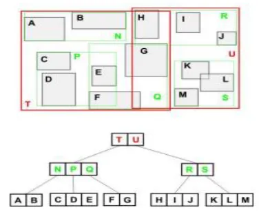
power to the probing method. Figure 1, below
shows an R-Tree example, where the rectangles
in red, green and ebony color shows MBRs.
2.
Related Work
2.1 SPATIAL KEYWORD SEARCHING
METHODS
Keyword search on spatial information mainly
based on various indexing methods and
querying methods. Here briefly presents some
A. Top-k spatial keyword search using
IR2-Tree:
Felipe et al. [1] proposed an efficient search
method to recover top-k spatial keyword. An
index structure IR2-Tree (Information Retrieval
R-Tree) that cumulates R-Tree and signature
files to sanction keyword search on spatial
information objects. A spatial keyword query
consists of a set of keywords plus query field.
The effect is a list of objects ranked according
to their text pertinency and distance to the query
area. Signature file is utilized for text indexing.
A signature file is to perform membership tests
to determine whether a query word w subsists
Fig. 1.R-Tree example.
In a set of words W. Represented as a sequence
of bits (either 0 or 1). for each one bit represents
the presence or absence of a term in a document.
Bit 1 represents presence of a term and 0
otherwise. IR2-Tree is having some drawbacks,
which impacted on its efficiency. The
disadvantage of this method is high false
convinced place. Figure 2, below shows
signature file representation for a sample
information set.
Algorithm for Distance Measure and Sorting
using KNN Euclidian
B. Top-k spatial keyword search using
IR-Tree
Another indexing method is for processing the
location-aware top-k text retrieval (LkT) query
Input: user u, user_loc u(latu, lonu,), result set loc { lati, lonj },
Output: Sorted result r.
Initialize distance d, collection c, double rad.
Let user u locations latu, lonu,
for(lati, lonj ϵ(i,j) where i,j search results
rad= Math.sin(latu) *
Math.sin(lati) + Math.cos(latu) * Math.cos(lati) *
Math.cos(lonu-lonj);
d=rad * 180 / Math.PI;
c.add(d);
end for;
while(d:c)
in ascending of d,
r=get(c),
end while;
[2]. In which query placement is so soon
determined and top-k results nearer to query
location are retrieved. All these answers satisfy
considerations afforded by the user. Both of the
works [2], [3] uses IR-Tree based indexing. This
framework integrates R-Tree and the inverted
file. Here an IR-Tree indexing is proposed that
is mainly an R-Tree extended with inverted
files.
3.
Implementation
3.1 Proposed work:
In keyword-NNE algorithm one query keyword
is culled as principal query keyword, and the
objects retrieved are more proximate to this
principal query keyword. So the query point will
be the principal object. And the inter object
distance from this point to other points of
fascinates should be minimum. The result places
are more proximate to the principal object.
Principal query keyword is culled as the one in
which number of objects will be minimum.
Albeit the method keyword-NNE outperforms,
it faces the following inhibitions.
Most of the geographic studies use distance as a
simple measure of accessibility. Straight-line
(Euclidean) distance is most often utilized in
spatial information bases because of the
facileness of its calculation. Genuine peregrinate
distance over a road network is a better
alternative, albeit historically an extravagant and
labour intensive task. This is erroneous always,
because utilizing commercial website one can
directly compute time and distance, without the
desideratum to own or purchase specialized GIS
software or street files.
Algorithm for BKC
Input: Item set I, Item Type T, Item Location (x, y), Item Rating R
Output: Result RS.
Initialization:
α Threshold of rating.
β Threshold of distance between Items .
let Item set [T1, T2, T3 .... Tm]
let Item set [I1, I2, I3 .... Ii]
for each Tm ∈ T
for each Ii ∈ I
if Ii..n(R) ≥ α
if Dist (Ii...n, Ii...n) ≥ β
Set S= Ii...n, Ii...n;
RS=S;
end if;
end if;
end for;
end for;
Capitalizing on this feature, compare
straight-line and peregrinate distance and peregrinate
time to calculate distance between query point
and other nearby locations. A major constraint
of keyword-NNE is that utilizer cannot
designate his current location. So that the query
does not retrieve distance of the path from
user’s current location to principal object in
GBKC. In lieu of taking euclidean distance from
user’s current location to the query point,
travelling distance and time is calculated.
Because euclidean distance may not always give
a precise result as utilizer expected. Let Ok be
the set of principal objects under principal query
keyword k. ok ∈ Ok be the principal object in
GBKCk. Distance of ok to the user’s current
location L is not designated in this method.
Shortest travelling distance of the path taken by
utilizer from location L to the principal object in
Ecumenical Best Keyword Cover can be
obtained utilizing Google API [14]. Integrating
this feature can make the probing more utilizer
cordial and give more support for a peregrinator
in good decision making. Another quandary
with the keyword-NNE method is that algorithm
set one query keyword with minimum number
of objects as principal keyword. So that the
retrieved results are circumvented by this
keyword.
Utilizer cannot give principal query keyword
according to his own cull. Suppose a utilizer
wants to ken locations more proximate to
non-principal object, such provision is not provided
in this algorithm. In current location predicated
most proximate keyword search utilizer can set
any keyword as principal query keyword
according to his cull. In lieu of culling the one
with minimum number of objects, utilizer can
set principal keyword as the first entered
keyword. The method can retrieve identically
tantamount result (GBKC) as keyword-NNE.
Along with that result utilizer can cull an object
in GBKC and can probe user’s intrigued
keyword more proximate to that culled object.
3.2 Location aware closest keyword search in
spatial information:
The method is predicated on current location of
utilizer. Utilizer designates his points of interest
and current location. After calculating GBKC,
the system returns an itinerary (an orchestrated
route) covering user’s current location and POIs
(Points of Interest) initially designating current
location of utilizer. Utilizing Geocoding API,
corresponding address is converted to its
latitude and longitude. From the current location
most proximate object in GBKC is calculated,
and the process perpetuates up to the last object.
All these Points of Fascinates are represented as
waypoints in map. Waypoints designate an array
of points. It can alter a route by routing it
through the designated location(s). A waypoint
is designated as a latitude/longitude coordinate,
an encoded polyline, a place ID, or an address
these waypoints is engendered. So the method
engenders an itinerary (an orchestrated route)
covering users current location and all objects in
GBKC.
4.
Experimental Work
Fig 1Maximum memory consumed versus m (a
¼ 0.4).
Fig 2: User Authentication Page.
Fig 3: User Keyword Search Page.
Result Data:
Here, We collect rating and distance of 20 items
which include restaurants, hotel, and bar in
hyderabad city. We can see datasets having
minimum 6 rating out of 10, and distance
between items not more than 5 kilometers. We
set T-value for rating is 6 and set T-value for
distance is 5 km.
r1 r2 dist_ set_ city
10 10 0.034445468741273244 r1,h3 Hyderabad
6 10 2.125423063607505 r5,h3 Hyderabad
10 6 1.5345161156773186 r4,h3 Hyderabad
10 10 0.034445468741273244 r3,h3 Hyderabad
10 6 0.0 r1,b1 Hyderabad
10 10 0.04097215169298834 r1,b3 Hyderabad
6 10 2.0910343303392485 r5,b1 Hyderabad
6 10 2.099178483409685 r5,b3 Hyderabad
10 10 1.5553497400044018 r4,b1 Hyderabad
10 10 1.5200520176180228 r4,b3 Hyderabad
10 10 0.0 r3,b1 Hyderabad
10 8 0.04097215169298834 r3,b3 Hyderabad
10 10 0.034445468741273244 h3,b1 Hyderabad
10 9 0.049921470865877234 h3,b3 Hyderabad
10 7 0.034445468741273244 r1,h3,b1 Hyderabad
6 10 0.034445468741273244 r5,h3,b1 Hyderabad
10 10 0.034445468741273244 r4,h3,b1 Hyderabad
10 10 0.034445468741273244 r3,h3,b1 Hyderabad
10 10 0.049921470865877234 r1,h3,b3 Hyderabad
7 10 0.049921470865877234 r5,h3,b3 Hyderabad
10 9 0.049921470865877234 r4,h3,b3 Hyderabad
10 10 0.049921470865877234 r3,h3,b3 Hyderabad
5.
Conclusion
Keyword Cover query provides an incipient
amended spatial keyword probing method, in
which keyword evaluation is con-sidered. The
method is connoted on keyword- NNE
algorithm. In location cognizant most proximate
keyword search in spatial information user’s
current location is additionally taken. So the
method is predicated on locationcognizant most
proximate spatial keyword querying. Along with
the results of keyword-NNE, user’s current
location and distance of the path is retrieved. To
get a path to users points of interest Google
waypoints are utilized. In lieu of Euclidean
distance, travelling distance is calculated to get
precise results. So that an itinerary covering all
the POIs is engendered and the peregrinator can
peregrination to his fascinated location. The
scope of future work relies on the following
cases. The default mode of conveyance is
driving; all other modes (ambulating, bicycling,
and transit) have to be considered in future.
Additionally multiple routes covering users
POIs have to be considered.
6. References
[1] D. Felipe, V. Hristidis, and N.
Rishe,”Keyword search on spatial information
bases,” IEEE 24th Int. Conf. Information Eng.,
pp.656-665, 2008.
[2] G. Cong, C. Jensen, and D. Wu, ”Efficient
retrieval of the top-k most relevant spatial web
objects,” Proc. VLDBEndowment, vol. 2, no. 1,
pp. 337348, Aug. 2009.
[3] Z. Li, K. C. Lee, B. Zheng, W.-C. Lee, D.
Lee, and X. Wang,”IRTree: An efficient index
for geographic documentsearch,” IEEE Trans.
Knowl. Information Eng., vol. 99, no. 4, pp.
585-599, Apr. 2010.
[4] R. Hariharan, B. Hore, C. Li, and S.
Mehrotra, ”Spatial-keyword (SK) queries in
geographic informationretrieval(GIR) systems,”
IEEE 19th Int. Conf. on SSDBM, 2007.
[5] D. Zhang, Y. Chee, A. Mondal, A. Tung,
and M. Kitsuregawa.,”Keyword searches in
spatial information bases: Towardssearching by
document,” IEEE Int. Conf. Information Eng.,
pp. 688-699, 2009.
[6] D. Zhang, B. Ooi, and A. Tung,”Locating
mapped resources in web 2.0,” IEEE 26th Int.
Conf. Information Eng., pp. 521-532, 2010.
[7] Ke Deng, Xin Li, Jiaheng Lu, and
XiaofangZhou,”Best Keyword Cover Search,”
IEEE Trans. Knowl.Information Eng.,vol. 27,
January 2015.
[8] Zhicheng Li, Hu Xu, Yansheng Lu, Ailing
Qian,”Aggregate Nearest Keyword Search in
Spatial Information bases,” IEEE12th
International Asia-Pacific Web Conference,
2010.
[9] Gnttman A,”R-trees: A Dynamic Index
Structure for Spatial Searching,” Proc. ACM
SIG MOD Int. Coaf. OnManagement, pp.