www.hydrol-earth-syst-sci.net/19/1287/2015/ doi:10.5194/hess-19-1287-2015
© Author(s) 2015. CC Attribution 3.0 License.
Reply to D. L. Peters’ Comment on “Streamflow input
to Lake Athabasca, Canada” by Rasouli et al. (2013)
K. Rasouli1, M. A. Hernández-Henríquez2, and S. J. Déry2
1Centre for Hydrology, University of Saskatchewan, Saskatoon, Saskatchewan, Canada 2Environmental Science and Engineering Program, University of Northern British Columbia, Prince George, British Columbia, Canada
Correspondence to: S. J. Déry ([email protected])
Received: 8 October 2014 – Published in Hydrol. Earth Syst. Sci. Discuss.: 4 November 2014 Revised: 29 January 2015 – Accepted: 10 February 2015 – Published: 6 March 2015
Abstract. This paper provides a reply to a comment from Peters (2014) on our recent effort focused on evaluating changes in streamflow input to Lake Athabasca, Canada. Lake Athabasca experienced a 21.2 % decline in streamflow input between 1960 and 2010 that has led to a marked de-cline in its water levels in recent decades. A reassessment of trends in naturalized Lake Athabasca water levels shows insignificant changes from our previous findings reported in Rasouli et al. (2013), and hence our previous conclusions re-main unchanged. The reply closes with recommendations for future research to minimize uncertainties in historical assess-ments of trends in Lake Athabasca water levels and to better project its future water levels driven by climate change and anthropogenic activities in the Athabasca Lake basin.
1 Reply
We thank Peters (2014; hereafter P14) for his comment on our recent article focusing on streamflow input to Canada’s Lake Athabasca (Rasouli et al., 2013; hereafter R13). This reply provides us with an opportunity to respond to the con-cerns raised in P14, to clarify the objectives of R13, to update and reaffirm our previously published results, to elaborate on their possible implications on Lake Athabasca water levels, and to propose recommendations for future work. To frame our response, we first outline briefly the two main issues of concern expressed in P14. Issue 1: P14 raises uncertainties on R13’s reported trend in the (partially) naturalized levels of Lake Athabasca that omitted its hydraulic connectivity to the Peace–Athabasca Delta (PAD), a 6 % streamflow
diver-sion from the Athabasca River towards Mamawi Lake down-stream of the McMurray hydrometric gauge, a geodetic refer-ence change in 2010 for the hydrometric station near Crack-ingstone Point, the filling of the Williston Reservoir on the upper Peace River from 1968 to 1971, regulation of the Peace River for hydroelectricity operation between 1972 and 1975, and the occurrence of ice-jam floods in 1974, 1996 and 1997 that obstructed the northward drainage from Lake Athabasca. Issue 2: the simple linear extrapolation of the 1960–2010 Lake Athabasca levels to 2100 provides misleading informa-tion on their potential future fate. We address these points af-ter revisiting the principal objective and conclusions of R13.
1.1 Past streamflow input to Lake Athabasca
in streamflow input to Lake Athabasca in recent decades is supported by other studies, and R13’s principal conclusions remain valid.
1.2 Past Lake Athabasca levels
The first main point of concern expressed in P14 is the poten-tial impact of streamflow changes on Lake Athabasca water levels. We agree that an accurate analysis of observed trends in Lake Athabasca levels requires consideration of three fac-tors neglected in R13: (1) hydrological interactions between the PAD and Lake Athabasca; (2) the geodetic reference change at the hydrometric gauge near Crackingstone Point in 2010; and (3) the filling of the Williston Reservoir behind the WAC Bennett Dam from 1968 to 1971. We update here the analyses presented in R13 to further naturalize the Lake Athabasca levels in consideration of these issues, but demon-strate that this leads to insignificant changes to our previ-ously published results and conclusions. Prior to that, how-ever, we emphasize that R13 addresses this topic as a point of discussion, rather than as a part of their results, and that it is not a primary objective of that study. As such, the lake level changes over 1960–2010 owing to streamflow input de-clines reported by R13 are of first order only. A comprehen-sive assessment of changes in the levels of Lake Athabasca clearly requires a more rigorous approach, including an anal-ysis of vertical (e.g., precipitation, evaporation, infiltration, etc.) and horizontal (e.g., total streamflow input and output, groundwater exchanges, etc.) water fluxes to the lake in ad-dition to anthropogenic influences (e.g., bitumen extraction). This should also include consideration of flows (i.e., 6 %) diverted from the Athabasca River towards Mamawi Lake (which would strengthen the declining trends of streamflow input to Lake Athabasca) and the hydraulic connectivity of Lake Claire, Mamawi Lake, and the remainder of the PAD with Lake Athabasca (P14). Such an analysis was clearly be-yond the scope and objectives of R13’s study. Nevertheless, we note that our (partially naturalized) lake level trend analy-sis closely matches the corresponding value obtained through streamflow input changes, providing confidence in the relia-bility of those initial results (consult R13).
[image:2.612.328.524.120.209.2]Following P14’s suggestion, and for completeness, we up-date and reassess our trend estimates of the 1960–2010 lev-els of Lake Athabasca near Crackingstone Point (station ID 07MC003) using the Mann–Kendall test (MKT; Mann, 1945; Kendall, 1975; Déry et al., 2005). Here, the lake levels are naturalized to consider the 2010 shift in the Crackingstone Point benchmark elevation and artificial modifications dur-ing the filldur-ing of the Williston Reservoir in British Columbia and regulation of the Peace River for hydropower develop-ment and generation, in addition to the obstruction of Lake Athabasca drainage northward caused by occasional ice-jam flood events in the lower Peace River and construction of weirs on the channels controlling the lake outflow (as al-ready considered in R13). High stage on the lower Peace
Table 1. Linear trends (m yr−1) of the naturalized lake levels at two locations on Lake Athabasca over 1960–2010 withpvalues given in parentheses (JJA: June–August, SON: September–November, DJF: December–February, MAM: March–May).
Period Crackingstone Point Fort Chipewyan
Annual −0.016 (0.02) −0.016 (0.02) JJA −0.016 (0.01) −0.016 (0.02) SON −0.021 (0.01) −0.021 (0.01) DJF −0.018 (0.01) −0.017 (0.01) MAM −0.009 (0.13) −0.009 (0.12)
July −0.016 (0.02) −0.014 (0.03)
River can affect the levels of Lake Athabasca through hy-draulic damming that can reverse the direction of lake out-flows (P14). As such, the construction of the WAC Bennett Dam on the upper Peace River and the ensuing water reten-tion behind it in the Williston Reservoir over 1968–1971 re-quires special attention owing to its possible impacts on Lake Athabasca levels. This is therefore considered in our updated analyses, in addition to the construction of weirs in 1975 and 1976 on the outflow channels draining Lake Athabasca and the 2010 benchmark elevation change of 0.709 m at Crack-ingstone Point.
(a)
[image:3.612.131.471.63.359.2](b)
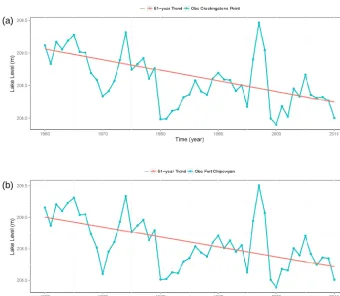
Figure 1. Time series and linear trends of naturalized, mean annual level of Lake Athabasca observed (Obs) (a) near Crackingstone Point and (b) at Fort Chipewyan, 1960–2010.
Next, the Lake Athabasca level data at Fort Chipewyan (station ID 07MD001) are added for supplemental analy-ses of annual, seasonal, and July trends in lake levels for comparison with the results near Crackingstone Point over 1960–2010 (Fig. 1). The two stations exhibit similar and sta-tistically significant (p <0.05) declining trends in mean an-nual and seasonal lake levels except during spring (March– May; see Table 1). The magnitude and significance of trends in naturalized Lake Athabasca levels are nearly identical whether assessed with hydrometric data from near Cracking-stone Point or at Fort Chipewyan, with the correlation co-efficient between the two time series of annual lake level at-taining 0.99 (p=0) over 1960–2010. Strong declining trends from 1971 to 2010 in fall and winter (September to Febru-ary) suggest that the high lake levels in the early 1960s are not a significant reason for recent declining lake level trends (not shown). If high lake levels in the early 1960s are lead-ing to the declinlead-ing trends, then high flows in 1997 and 1998 are moderating the declining trends. Removing the high lake levels in the late 1990s from the time series can result in even stronger declining trends. The updated results presented here demonstrate that adjusting the 2010 lake level for the change in datum reference and for naturalizing the lake levels during the filling of the Williston Reservoir in the upstream portion
of the Peace River does not affect in any significant manner the findings and conclusions of R13.
1.3 Future Lake Athabasca levels
re-gion and ongoing power generation from the rivers feeding Lake Athabasca during the twenty-first century. P14 men-tions the higher levels of Lake Athabasca during the LIA inferred from those seen in the same sediment core, which highlights the high variability in lake levels. However, given the above-mentioned reasons and the declining streamflow input to Lake Athabasca reported in R13, and hence its level, it seemed irrelevant to bring this matter into our discussion.
We concur that a detailed analysis of future climatic con-ditions and hydraulic controls would allow better projections of twenty-first century Lake Athabasca levels, but argue that forthcoming anthropogenic activities in the basin must also be taken into consideration. Thus, a more rigourous approach to better constrain estimates of potential future levels of Lake Athabasca is to employ global climate models (GCMs) or regional climate models (RCMs) driven by future green-house gas emissions scenarios. For instance, Kerkhoven and Gan (2011) apply seven GCMs forced by Special Report on Emissions Scenarios (SRES) A1FI, A2, B1, and B2 to in-vestigate the twenty-first century sensitivity of the hydrol-ogy of two major watersheds of western Canada, the Fraser and Athabasca River basins. Across all four scenarios and seven GCMs, they find a 21.1 % decline in the mean annual flows of the Athabasca River from 2070 to 2099 with respect to the baseline period 1961–1990. Such a decline, if real-ized, would double the reduction in Lake Athabasca levels observed over 1960–2010 from changes in streamflow input only.
The impacts of future climate change on streamflow in-put to Lake Athabasca assessed with climate models do not consider anthropogenic activities such as water withdrawals for human consumption, irrigation, and bitumen extraction. The hydrometric gauge on the main stem Athabasca River at McMurray remains upstream of the major Alberta oil sands deposits and does not reflect water withdrawals related to bi-tumen extraction. Pavelsky and Smith (2008) report that cur-rent water extraction related to oil production in the Alberta oil sands will rise and triple from 0.54 km3yr−1in 2006 to 1.61 km3yr−1in 2015. Since most of that water does not re-turn to the Athabasca River, it could lead to a further 0.21 m decline in lake levels in 2015, with the potential for greater impacts later in the century if bitumen extraction continues to intensify (e.g., Jordaan et al., 2009).
2 Conclusions and recommendations
This reply to a comment from P14 confirms our previous findings and conclusions on the magnitude of streamflow input declines in the Lake Athabasca drainage with poten-tial impacts on its level over 1960–2010. R13 reported a 7.22 km3or 21.2 % decline in total streamflow input to Lake Athabasca over 51 years that alone could lead to a 0.95 m reduction of its levels. This result was entirely consistent with the observed decline of 0.82 m in Lake Athabasca
lev-els measured near Crackingstone Point over the same study period. Naturalizing the time series of Lake Athabasca lev-els for consideration of a geodetic reference change in 2010 near Crackingstone Point and for the filling of the Williston Reservoir on the upper Peace River in 1968–1971 does not alter our previous estimates of potential lake level changes. Furthermore, a comparison of the trends in the naturalized levels of Lake Athabasca recorded near Crackingstone Point to those at Fort Chipewyan reveals nearly identical results for 1960 to 2010. Thus, despite the concerns expressed in P14, the conclusions obtained by R13 on Lake Athabasca stream-flow input and levels remain entirely valid.
The proliferation of recent work on the hydrology of the Lake Athabasca drainage demonstrates the keen interest that exists in better understanding this economically and ecolog-ically important basin. We therefore end this reply with the following recommendations for future research efforts:
1. A comprehensive water budget for Lake Athabasca with consideration of all major freshwater fluxes over a his-torical period remains a priority for future research. This could include a combination of observed and sim-ulated water fluxes to develop a century-scale water budget for Lake Athabasca with impacts on its water levels. Remote sensing products could also supplement observational and modelling data sets, either through optical data to estimate changes in surface water area (e.g., Pavelsky and Smith, 2008) or gravimetric data for total volumetric changes in basin-scale water storage (e.g., Sheffield et al., 2009).
2. The construction of the large Site C dam by BC Hydro on the Peace River near Fort St. John, BC, was recently approved in December 2014, which may lead to further alterations on the hydrology of the Lake Athabasca sys-tem. Future work should therefore assess the possible hydrological impacts of the planned Site C dam, in ad-dition to the possible consequences imposed on this sys-tem (e.g., recharge of the PAD).
3. Augmenting the network of hydrometric gauges along rivers draining into Lake Athabasca, especially on the main stem Athabasca River downstream from the Al-berta oil sands operations, is of great priority and should be implemented immediately. This is particularly im-portant to assess the rapidly intensifying demands for freshwater (sourced mainly from the Athabasca River it-self) used in the extraction of bitumen from the oil sands operations in the region.
of this drainage basin and provide insights into its cur-rent state and future fate. In addition, trend analysis of historical hydroclimatic records can only provide near-future hydrological prospects of the Lake Athabasca system, and thus climate models are needed for long-term projections.
5. Projecting future inflows to Lake Athabasca with po-tential impacts to its levels necessitates high-resolution output from GCMs or RCMs to drive state-of-the-art hydrological models (e.g., the Variable Infiltration Ca-pacity model; Liang et al., 1994; Kang et al., 2014). These climate model simulations require full consider-ation of anthropogenic influences (i.e., land cover/use changes, flow regulation and retention, and water ex-traction), climate variability (i.e., impacts of the phase change of large-scale teleconnections such as El Niño– Southern Oscillation (ENSO) and Pacific Decadal Os-cillation (PDO) on lake inflows), in addition to a range of climate change scenarios, to assess the potential fu-ture freshwater supply in the Lake Athabasca drainage. These climate simulations should also assess the di-minishing contribution of glacier melt to runoff gener-ation in the headwaters of the Athabasca River (Mar-shall et al., 2011). This will lead to improved knowl-edge of the potential future variability and extremes in Lake Athabasca levels, allowing for better management of freshwater resources, policy development and adap-tation strategies in northern Canada.
6. Exchanges of information from holders of traditional knowledge and that derived from western science should be undertaken to obtain a broader perspective on observed changes in the Lake Athabasca drainage. Merging these two lines of knowledge has been shown to provide corroborating evidence on the impacts of cli-mate change on the environment, including water re-sources (e.g., Sanderson et al., 2015). We thus encour-age a continued dialogue between First Nations com-munities living in and near the watersheds flowing into Lake Athabasca and western scientists to expand our knowledge of this important system in a period of ac-celerating environmental and climate changes.
Acknowledgements. Funding provided by the government of Canada’s Canada Research Chair (CRC) program and an NSERC Discovery Grant awarded to S. J. Déry. Sincere thanks also to Stewart Rood (University of Lethbridge) and David Sauchyn (University of Regina) for their constructive comments that led to an improved paper.
Edited by: A. Ghadouani
References
Bawden, A. J., Linton, H. C., Burn, D. H., and Prowse, T. D.: A spatiotemporal analysis of hydrological trends and variability in the Athabasca River region, Canada, J. Hydrol., 509, 333–342, 2014.
Déry, S. J., Stieglitz, M., McKenna, E. C., and Wood, E. F.: Char-acteristics and trends of river discharge into Hudson, James, and Ungava Bays, 1964–2000, J. Climate, 18, 2540–2557, 2005. Jordaan, S. M., Keith, D. W., and Stelfox, B.: Quantifying land use
of oil sands production: A life cycle perspective, Environ. Res. Lett., 4, 024004, doi:10.1088/1748-9326/4/2/024004, 2009. Kang, D. H., Shi, X., Gao, H., and Déry, S. J.: On the changing
contribution of snow to the hydrology of the Fraser River Basin, Canada, J. Hydrometeorol., 15, 1344–1365, 2014.
Kendall, M. G.: Rank Correlation Methods, Charles Griffin, Lon-don, 160 pp., 1975.
Kerkhoven, E. and Gan, T. Y.: Differences and sensitivities in po-tential hydrologic impact of climate change to regional-scale Athabasca and Fraser River basins of the leeward and windward sides of the Canadian Rocky Mountains respectively, Climatic Change, 106, 583-607, doi:10.1007/s10584-010-9958-7, 2011. Liang, X., Lettenmaier, D. P., Wood, E. F., and Burges, S. J.: A
simple hydrologically based model of land-surface water and en-ergy fluxes for general-circulation models, J. Geophys. Res., 99, 14415–14428, 1994.
Mann, H. B.: Nonparametric tests against trend, Econometrica, 13, 245–259, 1945.
Marshall, S. J., White, E. C., Demuth, M. N., Bolch, T., Wheate, R., Menounos, B., Beedle, M. J., and Shea, J. M.: Glacier water re-sources on the eastern slopes of the Canadian Rocky Mountains, Can. Water Resour. J., 36, 109–134, 2011.
Muzik, I.: Hydrology of Lake Athabasca, Hydrology of Natural and Manmade Lakes, Proc. of the Vienna Symposium, August 1991, IAHS-AISH Publ., 226, 13–22, 1991.
Nogués-Bravo, D., Araújo, M. B., Errea, M. P., and Martinez-Rica, J. P.: Exposure of global mountain systems to climate warming during the 21st Century, Global Environ. Change, 17, 420–428, 2007.
Pavelsky, T. M. and Smith, L. C.: Remote sensing of hydrologic recharge in the Peace-Athabasca Delta, Canada, Geophys. Res. Lett., 35, L08403, doi:10.1029/2008GL033268, 2008.
Peters, D. L.: Comment on “Streamflow input to Lake Athabasca, Canada” by Rasouli et al. (2013), Hydrol. Earth Syst. Sci., 18, 3615–3621, doi:10.5194/hess-18-3615-2014, 2014.
Peters, D. L., Atkinson, D., Monk, W. A., Tenenbaum, D. E., and Baird, D. J.: A multi-scale hydroclimatic analysis of runoff gen-eration in the Athabasca River, western Canada, Hydrol. Pro-cess., 27, 1915–1934, doi:10.1002/hyp.9699, 2013.
Rasouli, K., Hernández-Henríquez, M. A., and Déry, S. J.: Stream-flow input to Lake Athabasca, Canada, Hydrol. Earth Syst. Sci., 17, 1681–1691, doi:10.5194/hess-17-1681-2013, 2013. Rood, S. B., Stupple, G. W., and Gill, K. M.: Century-long records
reveal slight, ecoregionlocalized changes in Athabasca River flows, Hydrol. Process., 29, 805–816, doi:10.1002/hyp.10194, 2015.
from western science and traditional knowledge, Can. Geogr., doi:10.1111/cag.12142, in press, 2015.
Sauchyn, D. J., Vanstone, J., and Perez-Valdivia, C.: Modes and forcing of hydroclimatic variability in the Upper North Saskatchewan River Basin since 1063, Can. Water. Resour. J., 36, 205–217, 2011.
Schindler, D. W. and Donahue, W. F.: An impending water crisis in Canada’s western prairie provinces, P. Natl. Acad. Sci., 103, 7210–7216, 2006.
Sheffield, J., Ferguson, C. R., Troy, T. J., Wood, E. F., and McCabe, M. F.: Closing the terrestrial water budget from satellite remote sensing, Geophys. Res. Lett., 36, L07403, doi:10.1029/2009GL037338, 2009.
Wilks, D. S.: Statistical Methods in Atmospheric Sciences, 3rd Edn., Academic Press, Amsterdam, 676 pp., 2011.
Wolfe, B. B., Hall, R. I., Edwards, T. W. D., Jarvis, S. R., Niloshini Sinnatamby, R., Yi, Y., and Johnston, J. W.: Climate-driven shifts in quantity and seasonality of river discharge over the past 1000 years from the hydrogeographic apex of North America, Geophys. Res. Lett., 35, L24402, doi:10.1029/2008GL036125, 2008.