item and our policy information available from the repository home page for further information.
Author(s):Ekpenyong, Frank; Brimicombe, Allan; Palmer-Brown, Dominic; Li, Yang; Lee, Sin Wee
Title: Automated updating of road network databases: road segment grouping using snap-drift neural network
Year of publication:2007
Citation:Ekpenyong, F. et al. (2007) ‘Automated updating of road network
databases: road segment grouping using snap-drift neural network’Proceedings of Advances in Computing and Technology, (AC&T) The School of Computing and Technology 2nd Annual Conference, University of East London, pp.160-167
Link to published version:
AUTOMATED UPDATING OF ROAD NETWORK DATABASES:
ROAD SEGMENT GROUPING USING SNAP-DRIFT NEURAL
NETWORK
A
Frank Ekpenyong,
AAllan Brimicombe,
BDominic Palmer-Brown,
A
Yang Li,
BSin Wee Lee
ACentre for Geo-Information Studies, University of East London; B School of Computing and Technology (SCOT), University of East London
Email: {F.U.Ekpenyong, A.J.Brimicombe, D.Palmer-Brown, Y.Li, S.W.Lee}@uel.ac.uk
Abstract: Presented in this paper is a major step towards an innovative solution of GIS road network
databases updating which moves away from existing traditional methods where vendors of road network databases go through the time consuming and logistically challenging process of driving along roads to register changes or GIS road network update methods that are exclusively tied to remote sensing images. Our proposed road database update solution would allow users of GIS road network dependent applications (e.g. in-car navigation system) to passively collect characteristics of any “unknown route” (roads not in the database) on behalf of the provider. These data are transferred back to the provider and inputted into an artificial neural net (ANN) which decides, along with similar track data provided by other service users, whether to automatically update (add) the “unknown road” to the road database on probation allowing subsequent users to see the road on their system and use it if need be. At a later stage when there is enough certainty on road geometry and other characteristics the probationary flag could be lifted and permanently added to the road network database. Towards this novel approach we mimicked two journey scenarios covering two test sites and aimed to group the road segments from the journey into their respective road types using the snap-drift neural network (SDNN). The performance of the SDNN is presented and its potential in the proposed solution is investigated.
1. Introduction.
Keeping the road network database up-to-date is important to many Geographic Information System (GIS) applications. Various existing and emerging applications require in particular up-to-date, accurate and sufficiently detailed road databases. Examples are in-car navigation, tourism, traffic and fleet management and monitoring, intelligent transportation systems, internet-based map services, and location-based services (Zhang, 2004a,
Wessel, 2004). Due to constantly increasing traffic density, automatic navigation systems in cars and trucks gain more and more importance (Holzapfel et al., 2003), so also the need for map network databases used in in-car navigation systems to be up-to-date and always conforms to ever changing real world.
major (road network update) functions; namely road extraction, change detection and change representation (Zhang, 2004b). Most of these works portrayed all three road update functions as topics of remote sensing and consequently different types of image processing algorithms have been developed for each purpose. While image based road updating approaches have recorded some success, its accuracy is directly tied to the quality of the data (Klang, 1998) and object model used for road extractions (Gerke et al., 2004).
Moving away from the concept of road network update exclusively with remote sensing images, we propose a practicable innovative solution whereby users of GIS road network dependent applications passively collect characteristics of any “unknown road” (roads not in the database) on behalf of the provider.
These data along with similar track data provided by other service users are transferred back to the provider and inputted into an artificial neural net (ANN) which decides whether to automatically update (add) the “unknown road” to the road database on probation allowing subsequent users to see the road on their system and use it if need be. At a later stage when there is enough certainty on road geometry and characteristics (cross-checking where necessary with other data sources such as remote sensing) the probationary flag could be lifted and permanently added to the road network database.
The ANN would rely on input (road attributes) it receives and predicts whether the “unknown route” is actually a road that needs to be added to the central database.
As a step towards this novel solution, in this paper we mimicked journey scenarios covering two test sites; East London and near Stansted Airport. We assume that the road segments supposedly travelled on are unknown road types and we seek to group these road segments into different road types using a snap-drift neural network (SDNN) to discover the features of local collected data.
This process will establish the extent to which the road charactersics naturally fall into the road classes (A roads, B roads, Minor roads and Local roads). We also present some key methodological issues of the investigation, a discussion of the variables and some preliminary results from the SDNN.
2. Key Concepts.
2.1. Mobile space-time envelope.
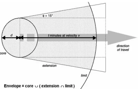
geographically ‘soft clip’ objects that fall within a subscription domain in anticipation of queries, and as a trigger for pushed alerts from publishers as subscribers come within range (Brimicombe and Li, 2006). The geometric component (Figure 1) of the envelope depends on the speed and direction of the subscriber. For more information on mobile space-time envelope refer to Brimicombe and Li, (2006).
To collect candidate road segments local context information - an abridged concept of the mobile-space time was employed in the study. For our purpose, we seek to group unknown candidate roads a user as been on. In this case such geographic areas (roads) have been pinpointed, so we are only faced with defining an optimal envelope size that would readily encapsulate local context information around all the candidate roads. In terms of the mobile space-time envelope concept, the changing shapes of the envelope are defined by particular road geometry while the size could be a defined buffer around the road segments in question. In this study we use 50m buffer to generate mobile space-time envelopes along the two journey routes. Local context information that is contained within each road segment envelope was collected as input for the neural network.
2.2. Snap-drift neural network. The
[image:4.612.327.566.117.272.2]strength of the ANN lies in its ability to derive meaning from complicated or imprecise data; ANNs can be used to extract
Figure 1: Geometric components of mobile space-time envelopes from Brimicombe and Li (2006).
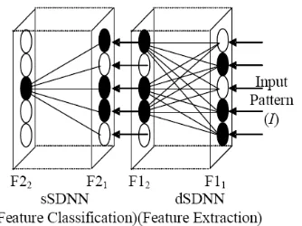
patterns or detect trends that are too complex to be noticed by either humans or other computer techniques (Winter and Taylor, 2003). Different types of neural networks have been employed in the past for map matching and road extraction purposes (Barsi et al., 2002, Fiset et al., 1998, Winter and Taylor, 2003). Within the context of this study the Snap-Drift neural network (SDNN) developed in recent years by Lee and Palmer-Brown, (2004) is deployed.
Figure 2: Snap-Drift Neural Network (SDNN) architecture from Lee and Palmer-Brown (2005)
Unlike back propagation network which performs optimization for classification rather than feature discovery by pushing features in the direction that minimizes error on the output nodes without any requirement for the feature to be statistically significant within the input data, SDNN toggles learning mode to find a rich set of features in the data and uses them to group the data into categories as exemplified in this paper. But it is also possible to utilise SDNN for classification purposes by reinforcement learning whereby the learning mode is toggled in order to maximise the class specificity of the output nodes (see Lee and Palmer-Brown, 2005b). That is yet to be completed in this case. In terms of this study, the clustering/grouping version of the SDNN was used to group road segments into the road types based on the road segment information and local context data supplied to it.
3. Data Description
Two mimicked journey scenarios shown in Figures 3 and 4 were used to generate the study data. Scenario one: 2.27km trip from “Holloway Road” to “Andrewes Gardens” (East London). Scenario two: 1.83Km trip from “Manor Road” to “The Grove” (near
Stansted Airport). According to OS Mastermap data model, each road segment stops and a new one (could be same road name) segment begins at road intersections. This implies that in both scenarios, the routes were made of sequences of connected road segments between the start and end point. Scenario one had 32 road segments while scenario two had 62 road segments. A buffer of 50m on each road segment was implemented, this way an envelope around each road segment (mobile space-time envelope around each journey route) was created. In total there were 93 road segments made up of 20 A roads segments, 30 B road segments, 13 local road segments and 30 minor road segments. Table 1 shows summary of all the available road patterns within the different road types that make up the two journey routes.
Figure 4: Test site 2 showing route 2 from Manor Road to The Grove near Stansted airport.
Table 1: Summary of different patterns within each road class considered.
Local context information on the following variables was collected for each envelope (road segment):
a) Length of road segment; b) Speed limit;
c) Address points;
d) Number of crossings/exits/side roads; e) Nature of road (single carriageway, dual
carriageway, etc).
3.1. Input Representation for SDNN. For the
input set used in the SDNN, there are 9 groups of variables represented by separate fields in the input vector. Length, speed limit, address point counts and number of crossings/exits/side roads variables were real number inputs. 5 bits binary encoding was used to represent the “nature of road” variables (Table 1). Out of the 93 road segments, 46 inputs (road segments) were randomly selected half from each road class and used to train the SDNN. The remaining 47 inputs were used for testing.
Figure 5: Plot of winning nodes gotten from SDNN result, dotted lines show road groupings that correspond to road classes
Nature of
road A road B road Local road Minor road Single
carriageway 8 20 13 28
Dual
Carriageway 10 0 0 0
Roundabout 0 4 0 0
Slip road 1 0 0 0 Traffic
Island 1 6 0 2
Total 20 30 13 30
Local Street
B road A road
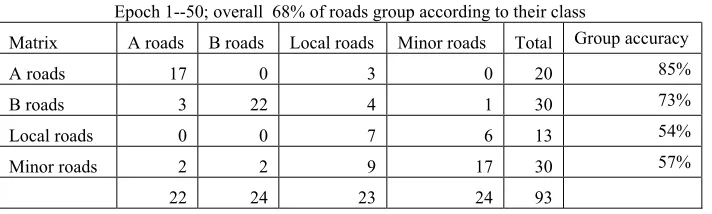
[image:6.612.111.508.486.641.2]3.2. Analysis of Results. Results are presented in Figure 5 and Table 2. In Figure 3, the dotted line shows each of the road types, namely A roads, B roads, local road and minor road. The SDNN groups about 62% of patterns into their actual classes after 10 epochs and converges after 50 training epochs (Table 2) at which point 68% of roads are grouped into their human-defined classes. SDNN was able to group the broad road types with individual road class accuracy above 70% except for the local and minor roads. The fact that local and minor roads in many cases do not fit neatly into their class groupings is likely to be because both road classes are characterised by few
[image:7.612.131.487.344.451.2]variables as shown in Table 1. Local road is made up of only single carriageway while the minor roads consist of 2 variables (28 single carriageways and 2 traffic islands - Table 1). In addition the small number of inputs available for the training could also affect the local road class grouping accuracy since only 6 out of 13 available local road input data were used for training compared to other road classes with between 20 - 30 inputs and half of each class randomly selected for training.
Table 2: Classification matrix of SDNN results
4. Conclusions and Future Work
The result of the SDNN offers a fast method of learning that preserves feature discovery and is capable of grouping road inputs patterns according to their local context information. However, it is also clear that simply performing unsupervised learning to find the most natural groupings is insufficient to classify all road types accurately. The result represents a positive first step towards updating road network by
using a candidate’s road local context information collected by the road users, but later work will involve applying the SDNN reinforced learning classifier for road classification using real user data collected and much larger road input patterns to see how it performs. A comparison of the performance of the classifier version of SDNN and back propagation network would also be carried out. At a later stage the SDNN would be applied to remote sensing images for the purpose of road network detection and extraction.
Epoch 1--50; overall 68% of roads group according to their class
Matrix A roads B roads Local roads Minor roads Total Group accuracy
A roads 17 0 3 0 20 85%
B roads 3 22 4 1 30 73%
Local roads 0 0 7 6 13 54%
Minor roads 2 2 9 17 30 57%
References
BARSI, A., HEIPKE, C. & WILLRICH, F. (2002) Junction Extraction by Artificial Neural Network System - JEANS.
International Archives ofPhoto grammetry and Remote Sensing, Vol. 34, Part 3B, pp. 18-21.
BAUMGARTER, A., ECKSTEIN, W., MAYER, H., HEIPKE, C. & EBNER, H. (1997) Context-Supported Road Extraction.
in Automatic Extraction of Man-Made Objects from Aerial and Space Images II, Birkhaeuser Verlag, Basel, pp. 299-308.
BRIMICOMBE, A. & LI, Y. (2006) Mobile Space-Time Envelopes for Loaction-Based Services. Transactions in GIS, 10, 5-23.
FISET, R., CAVAYAS, F., MOUCHOT, M.-C., SOLAIMAN, B. & DESJARDINS, R. (1998) Map-image matching using a multi-layer perceptron: the case of the road network. ISPRS Journal of Photogrammetry and Remote Sensing, 53, 76.
GERKE, M., BUTENUTH, M., HEIPKE, C. & WILLRICH, F. (2004) Graph-supported verification of road databases. ISPRS Journal of Photogrammetry and Remote Sensing, 58, 152.
HINZ, S. & BAUMGARTNER, A. (2000) Road extraction in urban areas supported by context objects. International Archives of
Photogrammetry and Remote Sensing, 33,
Part B3, 405-412.
HOLZAPFEL, W., SOFSKY, M. & NEUSCHAEFER-RUBE, U. (2003) Road
profile recognition for autonomous car navigation and Navstar GPS support. Aerospace and Electronic Systems, IEEE Transactions on,
39, 2.
KLANG, D. (1998) Automatic detection of changes in road databases using satellite imagery. International Archives of
Photogrammetry and Remote Sensing, 32 (Part
4), 293-298.
LEE, S. W. & PALMER-BROWN, D. (2005a) Modal Learning in A Neural Network. IN DODDS, S., HOSNY, W., JAHANKHANI, H., MOURATIDIS, H., PALMER-BROWN, D., PERRYMAN, R. & WIJEYESEKERA, C. (Eds.) 1st Conference in Advances in
Computing and Technology. London, United
Kingdom. pp 42-47.
LEE, S. W. & PALMER-BROWN, D. (2005b) Phrase recognition using snap-drift learning algorithm. The Internation Joint Conference on Neural Neural Networks (IJCNN' 2005).
Montreal, Canada, 31st July - 4th August.
LEE, S. W., PALMER-BROWN, D. & ROADKNIGHT, C. M. (2004) Performance-guided neural network for rapidly self-organising active network management.
Neurocomputing, 61, 5.
Information Sciences, Volume 35, Part 3B, pp. 360 - 365.
WINTER, M. & TAYLOR, G. (2003) Modular neural networks for map-matched GPS positioning. IEEE Web Information Systems Engineering Workshops (WISEW'03) pp. 106-111, December 2003.
ZHANG, C. (2004a) Towards an operational system for automated updating of road databases by integration of imagery and geodata. ISPRS Journal of Photogrammetry and Remote Sensing, 58, 166.
ZHANG, Q. (2004b) A Framework for Road Change Detection and Map Updating.