© 2018, IRJET | Impact Factor value: 6.171 | ISO 9001:2008 Certified Journal | Page 1123
FLOOD ALERTING SYSTEM THROUGH WATER LEVEL METER
Sophia S
Assistant professor, Dept. of computer science and Engineering, Dr. T. Thimmaiah institute of technology, Karnataka, India
---***---ABSTRACT: The main important thing that occurs after and
along with the disaster is information dissemination. One such disaster is flood, in this paper we make use of IOT internet to thing allows the use of devices that help the people to take the decision during such disaster. In this paper, sensor is used to measure the water level in river streams and lakes. Micro model is designed and constructed with sensor to measure experimentally the water container in controlled environment. The Micro model is programmable electronic board connected to electrical resistances that are placed at particular height within the water container. When the water rises and reaches the resistor, the impedance will vary that shows the different height of water level. Thereby the sensor transmits the information through the WiFi to Computer and also be seen in smart phones. From this users can see the water level in the river. At last micro model is examined under manipulated environment and acceptable results are obtained.
Keywords: IOT, Sensor, Node MCU ESP8266, Arduino
1. INTRODUCTION
The most vital thing some time recently, amid and after calamity is the dispersal of data. There exist a few sorts of cataclysmic events, it is realized that surge is a standout amongst the most hazardous since they have enough dangerous energy to change the course of streams, clear away and wreck whatever is in their way. Our inspiration for this work depends on all harms caused in our locale because of surges; this cataclysmic event has made many individuals endure harm to their homes and losing their effects [1].
The IOT enables items to be detected as well as controlled remotely crosswise over existing system framework, making open doors for more straightforward mix of the physical world into PC based frameworks, and bringing about enhanced effectiveness, precision and monetary advantage notwithstanding decreased human intervention [2].
It is critical to comprehend lacks in strategies and procedures for measuring water level in streams. CONAGUA right now screens stream levels in a mechanized manner on their site, thus unmistakable for everybody at any area, yet particularly for those living close riverbanks. In any case, it is realized that observing is not programmed since a gage plays out this undertaking by measuring stream stages with a limn metric manage, at that point, the information
gathered are caught physically and are shown on the CONAGUAs website [3].
Be that as it may, the above acquires lack the estimation procedure on the grounds that the information might not have been precisely caught and brought to where this data could be past the point of no return for help or arranging a save system.
The way that the information gathering of levels of water bodies is executed by a man and it conveys perils and postponements in the spread of data. One of these dangers is imperiling the individual who comes to make a move, as heavy rains access to the measuring focuses are to a great degree convoluted, and in instances of conceivable flooding these postponements are pivotal to rescuing assets and particularly the lives of individuals living in zones at risk. Because of the costly cost of gages to gauge water level and the significance of creating cautioning frameworks for measuring levels in streams that add to shield lives of subjects who occupy locales in threat of flooding, we display a water level sensor in light of water conductivity[4].
A sensor is introduced to gauge water level in waterways, lakes, tidal ponds and streams. For such reason and to demonstrate the idea, a pilot extend is outlined through a small scale display that is built with a water level estimation sensor in view of basic open circuit and is tentatively tried under a controlled environment[5].
© 2018, IRJET | Impact Factor value: 6.171 | ISO 9001:2008 Certified Journal | Page 1124 The Need of System is Extreme precipitation is winding up
noticeably more regular due to environmental change, in this manner it causes substantial flooding. This makes the need screen always the stream level, so the dependable sensors are basic to quantify the water level. As per area attributes, diverse measuring standards can be utilized to ready inhabitants at low-lying region about the adjustments in the level of water [7]. The fundamental goal of this paper is to gauge water level that empowers to know the measure of water in a waterway, it is likewise to comprehend what level it can wind up noticeably perilous in light of the fact that it might cause a flood, consequently, cause surges. The structure is used to prepared tenants at low-lying locales about changes in the level of water. Safe level of water can be expected in future to save life's[7].
2. Literature survey
Current emergency management and disaster recovery systems usually involve several parts such as communication infrastructure and an information management system. Forecasting flash flood by the over flowing of rivers is able to process, analyze (by means of rain gauge and stream gauge) and remotely sensed data to detect the occurrence of (including computer applications and programs), and communication capabilities are required a flood. This system is the ideal solution, but is quite expensive. A variety of hardware, software to support and maintain this water level measurement system. Several studies have designed river level sensors using databases, processing raw data, extracting information and sending wireless.
A prototype based on RFID tag bracelet to manage information in an emergency shelter and food services provided to refugees [8]. This emergency shelter is installed after occurring natural disasters (floods). First, refugees write on a RFID bracelet tag their ID (CURP), then different writing/reading are made according to services received at the emergency shelter, also food service delivery, control arrival/departure and delivery items of personal hygiene are stored in a database. A partial solution was proposed to problems for controlling temporary shelters during an emergency situation, thereby improving the recording and accessing for existing aid programs offered by temporary shelters. The disadvantage in an RFID system, a single read/write error can seriously affect work correctly and the control in shelters can be inefficient [9].
The automated river level monitoring network has several nodes (Node 1, Node 2,……Node N) which are river side points where the data acquisition systems are installed. These embedded systems are designed to operate without direct human supervision. These acquisition systems collect and store raw data and transmit them through GSM interfaces. The data are sent through the GSM network to a
remote server which is the Central Monitoring Unit (CMU) that collects data from all the active nodes [10]. This monitoring system contains a database that processes the raw data and extracts information based on natural criteria and estimates critical parameters. These obtained parameters are refreshed periodically and updated as soon as new raw data are received from the connected nodes [11].
The advantages are it provides wide geographic network coverage, highly dynamic radio transmission, high end to end packet delivery rate requirements and hostile system deployment environment [12]. The sensor network provides predictability about the possible flood occurrence and helps to estimate a timeframe to take necessary measures to mitigate damages of human life and properties [13]. The disadvantage are GSM/GPRS modems having serial interface are bulky and requires large space that adds to the weight of the node modules [14].
The real intent of the proposal is to achieve a flood early warning system. This micro-model can be developed based on a programmable electronic board (NODEMCU 8266). An electronic circuit that is located at a specific height above a water container. When the water level rises for different height, the information is transmitted to web server via Wi-Fi. After this information can be accessed by mobile devices, users can graphically see the data, these data show the values of water levels. We can get to know the amount of water level and at which level it becomes dangerous. We can consider warning system to alert residents at low-lying areas about changes in the level of water. Safe level of water can be predicted in future to save life’s[15].
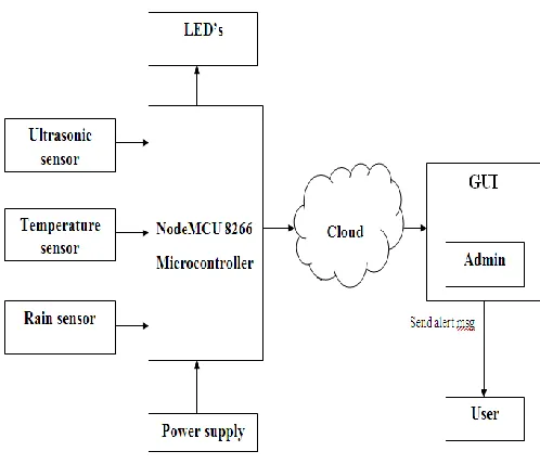
[image:2.612.323.572.494.708.2]3. SYSTEM ARCHITECTURE
© 2018, IRJET | Impact Factor value: 6.171 | ISO 9001:2008 Certified Journal | Page 1125 The proposed design for this framework is given above in fig
1[7]. It demonstrates the way this framework is composed and brief working of the framework. To begin with it brings water-level Values from the sensors (ultra-sonic, rain, temperature) and it is put away in cloud (thingspeak). At that point, contingent on the water-level esteems (low, medium, high) in the event that it is Low then it is green, medium is yellow and High is Red. In the event that red means at that point ready messages will sent to every enrolled client.
3.1 SENSORS
Sensors are utilized as a part of regular protests, for example, touch-delicate lift catches (material sensor) and lights which diminish or light up by touching the base, other than multitudinous utilizations of which the vast majority are never mindful. With progresses in small scale apparatus and simple to-utilize microcontroller stages, the employments of sensors have extended past the customary fields of temperature, weight or stream measurement,[1] for instance into MARG sensors. In addition, simple sensors, for example, potentiometers and compel detecting resistors are still generally utilized. Applications incorporate assembling and hardware, planes and aviation, autos, medication, mechanical autonomy and numerous different parts of our everyday life.
3.2 Classification of measurement errors
A decent sensor complies with the accompanying rules:it is delicate to the deliberate property
• It is obtuse to some other property prone to be
experienced in its application, and
• It does not impact the deliberate property.
Most sensors have a straight exchange work. The affectability is then characterized as the proportion between the yield flag and measured property. For instance, if a sensor measures temperature and has a voltage yield, the affectability is a steady with the units [V/K]. The affectability is the incline of the exchange work. Changing over the sensor's electrical yield to the deliberate units requires separating the electrical yield by the slant. What's more, a counterbalance is every now and again included or subtracted. For instance - 40 must be added to the yield if 0 V yield compares to - 40 C input. For a simple sensor flag to be handled, or utilized as a part of computerized gear, it should be changed over to an advanced flag, utilizing a simple to-computerized converter.
There are three sensors utilized as a part of this venture
• Rain Sensor
• Ultrasonic Sensor (Water-level sensor)
• Temperature Sensor
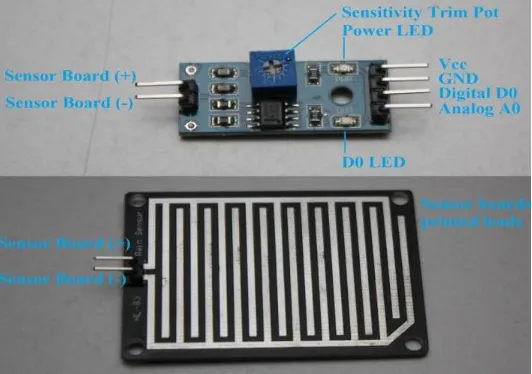
3.2.1 Rain Sensor
[image:3.612.318.584.229.416.2]Rain sensors are utilized as a part of the detection of water past what a dampness sensor can identify. The rain sensor Fig 2 identifies water that finishes the circuits on its sensor sheets' printed leads. The sensor board goes about as a variable resistor that will change from 100k ohms when wet to 2M ohms when dry. The wetter the board the more present that will be led.
Fig.2 Rain Sensor
3.2.2 Ultrasonic Sensor
[image:3.612.339.545.585.682.2]A Ultrasonic sensor is a gadget that can quantify the separation to a protest by utilizing sound waves. It allots remove by sending a sound wave at a particular recurrence and tuning in for that sound wave to skip back. Fig 4.3.1, By recording the slipped by time between the sound wave being created and the sound wave bobbing back, it is conceivable to ascertain the separation between the sonar sensor and the protest.
© 2018, IRJET | Impact Factor value: 6.171 | ISO 9001:2008 Certified Journal | Page 1126 Since it is realized that sound goes through air at around
344 m/s (1129 ft/s), you can set aside the ideal opportunity for the sound wave to return and increase it by 344 meters (or 1129 feet) to locate the aggregate round-trip separation of the sound wave. Round-trip implies Fig 3 that the sound wave voyaged 2 times the separation to the question before it was recognized by the sensor; it incorporates the "outing" from the sonar sensor to the protest AND the "outing" from the protest the Ultrasonic sensor (after the sound wave ricocheted off the protest). To discover the separation to the question, essentially isolate the round-trip remove down the middle
[image:4.612.362.534.64.191.2]Understand that a few articles won't not be distinguished by ultrasonic sensors. This is on the grounds that a few articles are formed or situated such that the sound wave bobs off the protest, however are diverted far from the Ultrasonic sensor. It is additionally workable for the protest be too little to reflect enough of the sound wave back to the sensor to be recognized. Different items can retain the sound wave all together (material, covering, and so forth), which implies that there is no chance to get for the sensor to recognize them precisely. These are vital components to consider when planning and programming a robot utilizing a ultrasonic sensor.
Fig.4. Ultrasonic sensor
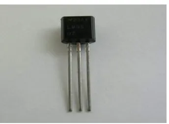
3.2.3 Temperature Sensor
A temperature sensor is a gadget, as appeared in Fig. 5 regularly, a thermocouple or RTD, which accommodates temperature estimation through an electrical flag. A thermocouple (T/C) is produced using two disparate metals that create electrical voltage in guide extent to changes in temperature. A RTD (Resistance Temperature Detector) is a variable resistor that will change its electrical resistance in guide extent to changes in temperature in an exact, repeatable and almost straight way.
Fig.5 Temperature Sensor
3.3 NodeMCU ESP8266
NodeMCU is an open source IoT platform. It includes firmware which runs on the ESP8266 Wi-Fi SoC from Espressif Systems, and hardware which is based on the ESP-12 module. The term "NodeMCU" by default refers to the firmware rather than the dev kits. The firmware uses the Lua scripting language. It is based on the eLua project, and built on the Espressif Non-OS SDK for ESP8266. It uses many open source projects, such as lua-cjson, and spiffs.
The ESP8266 is a low-cost Wi-Fi chip with full TCP/IP stack and MCU (microcontroller unit) capability produced by
Shanghai-based Chinese manufacturer, Espressif Systems.[1]
The chip first came to the attention of western makers in August 2014 with the ESP-01 module, made by a third-party manufacturer, AI-Thinker. This small module allows microcontrollers to connect to a Wi-Fi network and make simple TCP/IP connections using Hayes-style commands. However, at the time there was almost no English-language documentation on the chip and the commands it accepted. The very low price and the fact that there were very few external components on the module which suggested that it could eventually be very inexpensive in volume, attracted many hackers to explore the module, chip, and the software on it, as well as to translate the Chinese documentation.[3]
The ESP8285 is an ESP8266 with 1 MiB of built-in flash, allowing for single-chip devices capable of connecting to Wi-Fi. The successor to these microcontroller chips is the ESP32.
[image:4.612.62.269.378.549.2]© 2018, IRJET | Impact Factor value: 6.171 | ISO 9001:2008 Certified Journal | Page 1127
3.3.1. Features
32-bit RISC CPU: Tensilica Xtensa L106 running at 80 MHz*
64 KiB of instruction RAM, 96 KiB of data RAM
External QSPI flash: 512 KiB to 4 MiB* (up to 16 MiB
is supported)
IEEE 802.11 b/g/n Wi-Fi
Integrated TR switch, balun, LNA, power
amplifier and matching network
WEP or WPA/WPA2 authentication, or
open networks
16 GPIO pins
SPI
I²C
I²S interfaces with DMA (sharing pins with GPIO)
UART on dedicated pins, plus a transmit-only UART
can be enabled on GPIO2
10-bit ADC
[image:5.612.36.303.437.639.2]Both the CPU and flash clock speeds can be doubled by overclocking on some devices. CPU can be run at 160 MHz and flash can be sped up from 40 MHz to 80 MHz. Success varies chip to chip.
Fig 7 pin-out diagram of NODEMCU 8266
4. ARDUINO
Arduino is an open-source electronic platform in light of simple to-utilize equipment and programming. Arduino sheets can read inputs - light on a sensor, a finger on a catch,
or a Twitter message - and transform it into a yield - actuating an engine, turning on a LED, distributing something on the web. You can guide your board by sending an arrangement of directions to the microcontroller on the board. To do as such you utilize the Arduino programming dialect (in light of Wiring), and the Arduino Software (IDE), in light of Processing.
Throughout the years Arduino has been the mind of thousands of undertakings, from regular articles to complex logical instruments. An overall group of creators - understudies, specialists, craftsmen, developers, and experts - has accumulated around this open-source stage, their commitments have signified a mind boggling measure of available learning that can be of extraordinary help to fledglings and specialists alike.
Arduino was conceived at the Ivrea Interaction Design Institute as a simple instrument for quick prototyping, gone for understudies without a foundation in gadgets and programming. When it achieved a more extensive group, the Arduino board began changing to adjust to new needs and difficulties, separating its offer from straightforward 8-bit sheets to items for IoT applications, wearable, 3D printing, and inserted conditions. All Arduino sheets are totally open-source, enabling clients to assemble them autonomously and in the end adjust them to their specific needs. The product, as well, is open-source, and it is becoming through the commitments of clients around the world.
The Arduino software is difficult to-use for tenderfoots, yet sufficiently adaptable for cutting edge clients. It keeps running on Mac, Windows, and Linux. Educators and understudies utilize it to fabricate minimal effort logical instruments, to demonstrate science and material science standards, or to begin with programming and mechanical autonomy. Fashioners and engineers fabricate intelligent models, artists and craftsmen utilize it for establishments and to explore different avenues regarding new melodic instruments. Creators, obviously, utilize it to construct a considerable lot of the activities shown at the Maker Faire, for instance. Arduino is a key apparatus to learn new things. Anybody - kids, specialists, craftsmen, software engineers - can begin tinkering simply following the well ordered guidelines of a unit, or sharing thoughts online with different individuals from the Arduino people group.
© 2018, IRJET | Impact Factor value: 6.171 | ISO 9001:2008 Certified Journal | Page 1128 Projects composed utilizing Arduino Software (IDE) are
called portrays. These representations are composed in the content tool and are spared with the record expansion .ino. The editorial manager has highlights for cutting/gluing and for seeking/supplanting content. The message zone gives input while sparing and trading and furthermore shows blunders. The reassure shows content yield by the Arduino Software (IDE), including complete blunder messages and other data. The base righthand corner of the window shows the arranged board and serial port. The toolbar catches enable you to confirm and transfer programs, make, open, and spare portrays, and open the serial screen.
5. CONCLUSION AND FUTURE WORK
According to definitions of IoT, if we consider a sensor as an element of IoT which enables to communicate its current status and be published on Internet, then our proposal is very close to what we are intending to achieve within the concept of Internet of things. Nevertheless, the real internet of the proposal is to achieve a flood early warning system. So far, we have only built a micro-model through a prototype that sends an audible signal and graphical messages towards smart phones about the water level into a container.
This information was transmitted to a Cloud. After, this information can be accessed by mobile devices, users can graphically see the data, and these data show the values of water levels.
This work has few disadvantages that are no map
facility in order to find safest route and point.
Due to no escalation protocol is available, when
admin is not monitoring properly it leads to endanger many lives.
Future Work
Implementing Map to search for the safest place and route in order to evacuate from the impending Danger.
Developing an Escalation protocol for automation i.e.,if the admin is not able to take a necessary action within 5 minutes after red alert, automatically an action have to be take place.
Implementing the Temporary network forcommunication.
REFERENCES:
1. DIAD ALERT real-time weather monitoringand flood
warning, DIAD Incorporated, 20September 2000,pp. 1-4.
2. Guy Schumann, Renaud Hostache, ChristianPuech,
Lucien Hoffmann, Patrick Matgen,Florian
Pappenberger, and Laurent Pfister,High-Resolution 3-D Flood Information FromRadar Imagery for Flood Hazard Management,IEEE Transactions on Geoscience and RemoteSensing, VOL. 45, NO. 6, June 2007, pp. 1715-1725.
3. Gerardo Di Martino, Antonio Iodice, DanieleRiccio and
Giuseppe Ruello, A NovelApproach for Disaster
Monitoring: FractalModels and Tools, IEEE
Transactions onGeoscience and Remote Sensing, VOL. 45,NO. 6, June 2007, pp. 1559 – 1570.
4. Ramsey, W. and R. Burckley. 1966. Modern Earth
Science. Quezon City: KENInc.
5. McDaniel, M., E. Sprout, D. Boudreau and A. Turgeon.
2012. Flood. date accessed 17 August 2013
6. Mwape Y. P., 2009. An impact of floods on the socio-economic livelihoods of people:A case study of Sikaunzwe community in Kazungula District of Zambia.University of the Free State Faculty of Natural and Agricultural SciencesJournal 1(1): 1-87.
7. Devalsam E, I., J. E. Atu, C. Oko, I. Ekwok. 2011. Flood
and its impact onfarmland in Itigi, Abi Local
Government Area, Cross river State,
Nigeria.International Journal of Humanities and Social Sciences 1(9): 98-104.
8. Lu, J. and K. Whitehouse. 2007. Flash flooding:
Exploiting the capture effects forrapid flooding in wireless sensor networks. Department of Computer Science,University of Virgina Journal 1(1): 1-9
9. Khalequzzaman M. D. 2009. Flood control in
Bangladesh through bestmanagement practices. Department of Geology and Physics Journal 3(7): 1-13.
10. Simonovic, S.P. 1999. Decision support systems for
flood control management in theRed River Basin. Canadian Water Resources Journal 24(3): 203-223.
11. Devalsam E, I., J. E. Atu, C. Oko, i. Ekwok. 2011. Flood