Integrated Environmental Analysis using GIS for Rational
Planning of Conservatory Management of Slopes Application in
the Ouergha Basin (Morocco)
Imane Jaouda*, Ahmed Akhssas, Latifa Ouadif, Lahcen Bahi
3GIE Laboratory, Mohammadia Engineering School, Mohammed V University in Rabat, Morocco
Received: 8 January 2019 /Accepted: 20 March 2019
Abstract
The objective of this work is the realization of a map spatializing proposals of management and planning of lands, with a view to their rational management within the framework of a sustainable development. It was based on a diagnosis of the natural environment that allowed the analysis and identification of constraints to the development of the watershed of Ouergha (North of MOROCCO). The methodology consists of an analysis of the collected data through field surveys of farmers. For example, spatial data was organized into thematic layers of information on soils, land use, geology, erosion patterns and topography. The integration of these and other survey data into a Geographical Information System (GIS) has resulted in a management and land management map. The latter can serve as a basic document in the choice of the orientations, actions and development which will be taken by the actors of the development of the zone.
Keywords: Land Management and Management Map, GIS, Soil and Water Conservation, Ouergha, Morocco.
Introduction
The Ouergha watershed, as elsewhere throughout the Rif region, rational land management actions to increase crop yields and conserve natural resources must necessarily include all the appropriate anti-erosion techniques to curb the adverse effects erosion, which is an important factor in land degradation. In this sense, Rooze et al., (2012) analyze the three stages of evolution of research on water erosion and erosion control in the Maghreb countries.
In a first stage (1945-1970), in Morocco, after a report of the effects of erosion, DRS works on lands very degraded by water erosion were carried out. In a second stage (1965-1985), erosion is quantified notably by the Heusch team. Finally, during the last stage, since 1985, teams from ENFI, the Faculty of Humanities and Humanities of Rabat and IRD described thirty traditional systems of water management and soil fertility on the Rif and Atlas mountains. Several actions and projects to fight against erosion and for the development of agriculture succeeded one another in the studied perimeter and the surrounding areas.
The main purpose of the present work is to present the approach followed, with the final result being the establishment of the management and land management map in the selected perimeter. Its realization results from an analysis and integration of the different morpho-geo-pedological characteristics influencing the productivity of the grounds and constituting as many themes organized in a geographic database using the GIS tool. This article begins with an analysis of the physical context of the studied perimeter. Then we present the methodology adopted for the realization of the land management and land management map.
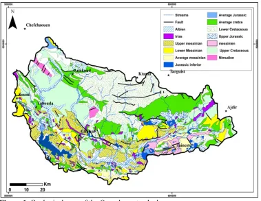
The studied perimeter is located in the Ouergha basin, which is located north of Morocco the perimeter totals approximately 6190Km2. The province of Taounate covers part of the Rif’s chain and its southern borders, the geological formations characterizing this province represent in part structural units of this chain and the neogenic formations within the mountains or the South Rifain corridor (Fig. 1). The structural sets of the outer Rif are represented by Late Miocene post-nappe formations. The numerous outcrops of chaotic material attributed to the Triassic are one of the characteristics of this region and consist mainly of variegated saliferous clays, gypsum dolerites, and constitute a level of detachment on which the whole Rifain chain has slipped (Suter 1965).
Figure 1.Geological map of the Ouergha watershed
The Ketama unit has a schisto-sandstone flysch of the lower Cretaceous some kilometers thick. The Ketama unit, consisting mainly of Jurassic and Cretaceous series, is affected by two phases of schistosity and two metamorphisms (the first phase is Oligocene age lower-Miocene inferior and the second phase is Late lower-Miocene age (Adrieux, 1971 Frizon De Lamotte, 1985).
The Aknoul aquifer is characterized by its superior structural position in the building of the intrafrust aquifers. In Taounate province, this water table straddles Ketama and Senhadja units. Unrevised ante-Senonian outcrops are rare. Black flysch type pelites, however, appear to Bab Hatri. They are very homogeneous, with little sandstone and rarely contain bands of marl or light marly limestones comparable to those found in the Cretaceous flysch of other intra-Riface nappes. It is most likely Aptien-Albien (Leblanc, 1980). The Ouezzane aquifer is interpreted as a syn-orogenic basin located at the front of ramp propagation anticlines (Tejera de Leon, 1993).
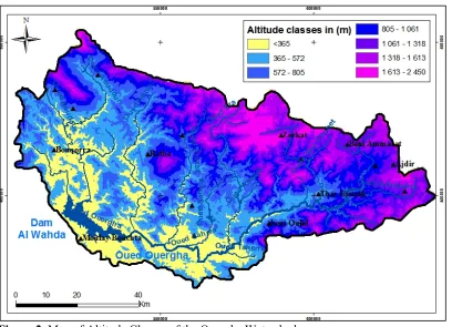
Digital Terrain Model (DTM) processing shows the peculiarity of the topo-hydrographic configuration characterized essentially by an elongated shape and a geomorphological heterogeneity (fig.2). The Ouergha watershed has a mountainous character with altitudes varying between 83 m and 2450 m. It shows a diversity of reliefs, with structural forms, closed depressions, ravines and forms of accumulation represented by alluvial terraces.
Figure 2. Map of Altitude Classes of the Ouergha Watershed
From the terrain map, relief is considered as a major factor reflecting the ability of a watershed to runoff. The main characteristics of the watershed are:
Ø The following two slices [800, 1000 m], [1300, 1600 m], which shows the mountainous nature of the basin;
Ø The lowest altitudes extend over the downstream part of the watershed.
Material and Methods
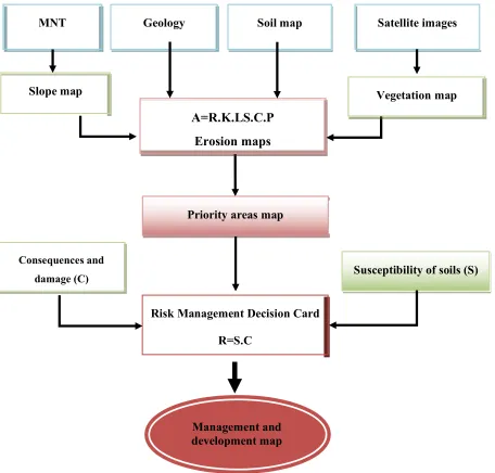
fact, once the superposition has been completed, the values of the homologous pixels in each of the layers are analyzed and grouped together into classes that are as homogeneous as possible, responding according to their characteristics to specific needs in terms of management and planning. These classes therefore correspond to the different map units of the map of Figure 3.
The units of the map of the figure therefore correspond to categories of land whose recommendations take into account the variability of their local spatial characteristics presented in the maps below (geological, lithological, morphological, terrain and elevation maps, land cover) and their constraints.
Figure 3. Combination of different thematic maps using GIS
The slope classes selected are: 0-8.5%, 8.5-16%, 16-24%, 25-33% and 33-74%. These classes are adopted because the slope value of 8.5% is considered as the limit between mechanizable farmland (<8.5%) and non-mechanizable farmland (> 8.5%). The slopes are quite important, those of less than 16% total 25%, including a relief of low hills and a few flats. On the other hand, those between 16 and 74% represent 58% and characterize a more rugged relief (Fig. 4).
MNT Geology Soil map
Slope map
Satellite images
A=R.K.LS.C.P Erosion maps
Vegetation map
Management and development map
Susceptibility of soils (S) Consequences and
damage (C)
Risk Management Decision Card
Figure 4. Map of the slopes of the Ouergha watershed.
Land occupation was obtained as a result of satellite imagery processing and bung
classification. Indeed, six main types of land use spread over the entire study area. (Jaouda et al., 2018).
Soil degradation: In the Rif, water erosion in the Ouergha catchment area is important
and constitutes a major constraint. It manifests itself in varying forms and intensities. And this for structural and climatic and anthropogenic litho logical reasons. The geological shows the significant extension of soft substrates of different ages that are susceptible to erosion such as marls, pelites, marno-schists and to some extent marl-limestones. Medium to strong slopes favor erosion processes. In fact, slopes exceeding 16% total more than 50% of all slope classes. The low vegetation cover poorly protects the soil against runoff caused by aggressive rains. Finally, overgrazing and inadequate land uses are also factors that promote land erosion (Jaouda et al., 2018).
The various forms of water erosion found in the study area are a reflection of a
Figure 5. Map of the main forms of water erosion
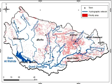
The analysis of the soil loss map gives the map of the priority areas of the Oued Ouergha watershed (fig.6). The distribution of vulnerable zones shows a real spatial heterogeneity linked mainly to the typology of soils and to the socio-economic vulnerability that characterizes the Ouergha watershed.
Priority areas, with a socio-ecological vulnerability, occupy 35% of the total surface area of the Oued Ouergha watershed. The majority of the rural communes in the study area require territorialized spatial planning interventions associated with specific socio-development programs.
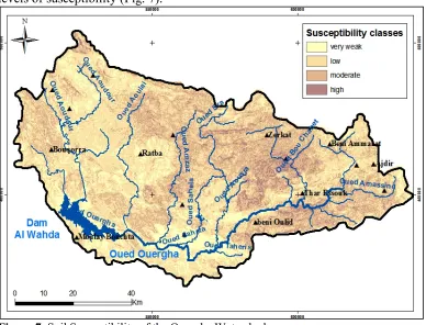
The response of the Ouergha catchment denotes a spatial homogeneity to the rainfall hazards in terms of land loss also revealing high peak flows for the different return periods. The analysis of cumulative curves made it possible to distinguish classes of homogeneous susceptibility for the Ouergha catchment. The reference hazard zoning obtained defines four levels of susceptibility (Fig. 7).
Figure 7. Soil Susceptibility of the Ouergha Watershed
This exploratory approach amply demonstrates the ability of the system to automatically generate hazard zoning and that almost a third of the watershed has moderate to strong levels of suspensability. This four-level hazard can be combined with a vulnerability defined in four levels. This would allow for risk maps.
Potential consequences: Analysis of the land data shows that the local economy is
mainly built on the primary sector (mixed farming and livestock farming). The structural damage and direct operation (CSF) map is the result of the superposition of land loss issues to human activities related to it (agricultural cost).
Figure 8. Consequences and damage of the Ouergha watershed
Results and discussion
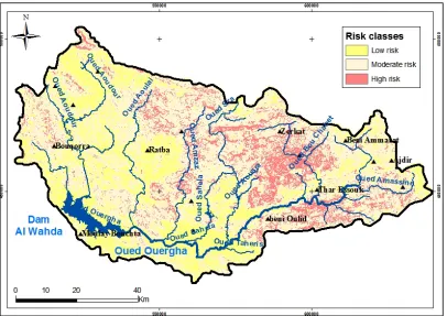
The risk decision map obtained from the spatial cross-referencing of susceptibility maps and potential consequences (Figure 10).
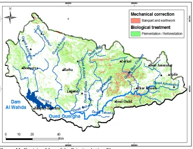
The priority management approach of major risk areas is based on the choice of operational actions (biological treatment and or mechanical correction of ravines) compatible with the intrinsic stakes of the Oued Ouergha slopes (fig.11).
Figure 11. Decision Map of the Priority Action Plan
The analysis of the spatial aggregation obtained in the environment is based on the exploitation of the spatial autocorrelation of each entity (pixel) with respect to the neighboring entities in a spatial dataset. As a result, the statistical significance of spatial autocorrelation is analyzed based on an approach of evaluating the statistical hypothesis based on the spatial data set obtained. For this purpose, the spatial modeling of the correlation structure is synthesized in the spatial connectivity decision map.
The advantage of mechanical engineering is the reduction of erosion at the Ouergha watershed, which will reduce:
• The risk of flooding of agglomerations and the destruction of public, industrial and private infrastructures;
• The siltation rate of the AL WAHDA dam;
• Maintenance work on basic infrastructure and downstream equipment. Other socio-economic impacts:
• • Improvement of the incomes and living conditions of the populations;
• • Creation of levers for other socio-economic projects;
• • Opening of the douars by the opening and the rehabilitation of the tracks;
• • Improvement of water supply and electricity.
22% of the watershed. On the other hand, the mechanical actions intended to reduce the effect of the slope and the installation of the isohypse structures (benches, ditches and earthworks) are programmed on an area 9% of the watershed of Oued Ouergha.
The execution of the intervention programs allows an improvement of the agricultural, fodder and forestry productions. The increase in agricultural production mainly concerns arboriculture and cereals. The increase in fodder production mainly concerns rangeland improvement, reforestation and forest restoration operations.
The restoration of the natural balance, through the reconstruction and rehabilitation of natural forest ecosystems and the development of rangelands, will allow the development and resettlement of natural vegetation. This will result in preservation and improvement of the flora and fauna in the area. Mechanical erosion control measures will protect and conserve soil capital and improve the quality of surface water and groundwater recharge.
Conclusion
The integrated and in-depth diagnostic conducted in the study area has enabled the development of a local spatial database using the GIS tool. The use and analysis of these spatial data led to the development of a management and land management map. Its realization results from an analysis and integration of the different morpho-geo-pedological characteristics influencing the productivity of the lands and constituting as many organized themes in the spatial database. The latter can be updated and fed as needed by other complementary information. It can help development officials in the area to guide and make decisions on the wise use and conservation of lands subject to major degradation processes.
The proposed management program consists of biological actions and mechanical gully correction measures. Thus, biological treatment concerns the watershed of Oued Ouergha, concerns mainly upstream in the sub-basins of Sahla, Amzaz and Sra. Thus, the program of biological actions corresponds to the work of fruit plantations on private land and regeneration and reforestation works for the reconstitution of degraded forests. Moreover, a quarter of the proposed biological interventions (29,935 ha), located mainly on slopes with steep slopes, must be combined with mechanical treatment actions to attenuate the amplitude of soil losses and the conservation of water resources.
Thus, the planned mechanical actions are mainly programmed for the zones at major risk of the erosive hazard, especially at the central level of the Ouergha watershed, notably the Amzaz and Sra sub-catchment and correspond to the setting up of benches, terraces and stabilization of the ravines. It should be noted that, in order to preserve biodiversity, the Action Plan obtained includes as a priority the restoration of ecological balances and the reconstruction of degraded soils to reverse the degradation trends and to control the potential risks related to soil loss. and siltation of the Al Wahda Dam downstream.
References
Andrieux, J. (1971). the structure of the central Rif. Study of the relationships between compression tectonics and slip sheets in a section of the Alpine chain. Notes and Memoirs of the Geological Survey of Morocco, 235, 1-155.
Durand Delga, M., and Villiaumey, M. (1963): On the stratigraphy and tectonics of the Jebel Musa group (Northern Rif, Morocco). Bulletin of the Geological Society of Franc, S7-V (1): 70-79. El Abassi H. (2000). The know-how of populations and management of water and soil in the
semi-arid mountain of Eastern Rif (Morocco). Bulletin Erosion Network, 20, 399-428. (Http://www.beep.ird.fr/collect/bre/index/assoc/HASH018e.dir/20-399-428.pdf).
FAO (1976). Framework for land evaluation. FAO Soil Bulletin, 32, Rome, 64 p.
FAO (1983). Guidelines for land evaluation for rainfed agriculture. FAO Soils Newsletter, 52, Rome, 237p.
Frizon de Lamotte, Dominique (1985). The structure of the eastern rif (Morocco): Role of longitudinal tectonics and the importance of fluids State doctorate: Earth, ocean, space: Paris 6. 1 vol 436 p .: ill. ; 30cm.
Ihissou Y. (2014). The case of the Tahar-souk area (Taounate Province). PFE, ENA Meknes, 95p. Jaouda, I., Akhssas, A., Ouadif, L., Bahi L., and Lahmili, A. (2017): Stability of Tillians and impact
on the road network: case of the outside basin of Ouergha (morocco). MATEC Web of Conferences 149, 02052 (2018) https://doi.org/10.1051/matecconf/201814902052 CMSS-2017. Jaouda, I., Akhssas, A., Ouadif, L. and Bahi, L. (2018): cartography of the vulnerability to erosion
by the combination of satellite images and GIS of Ouergha watershed (MOROCCO). ARPN Journal of Engineering and Applied Sciences. flight. 13(11), ISSN 1819-6608.
Leblanc, D., (1980). The Nekor accident and the structure of the Eastern Rif (Morocco). Journal of Dynamic Geology and Physical Geography 22, 267-277.
Leblanc D., Feinberg, H., H., Lorenz, H. (1983). Geological map of Rif: Taïneste, scale 1:50 000. Direction of geology. Ministry of Energy and Mines. Kingdom of Morocco.
Lespinasse P. (1977). Block marl from the Zoumi region; their significance in the structural evolution of the external zones of the Rif (Morocco). Bulletin of the Geological Society of France S7-XIX (4): 781-787.
Loukili M., Bock L., Engels P., Mathieu L. (2000). Geo-morpho-pedological approach and Geographic Information System (GIS) for land management in Morocco. EGS 7: 37-52.
Roose E., Sabir M. (2002). Traditional strategies for water and soil conservation in the Mediterranean Basin: classification for renewal use. Bulletin Erosion Network, 21, pp.3344. (Http://horizon.documentation.ird.fr/exloc/pleins_textes/pleins_textes_7/bre/010031028.pdf). Roose E., Sabir M., Arabi M., Morsli B., and Mazour M. (2012). Sixty years of cooperative research
on water erosion and erosion control in the Maghreb. Physio-Geo-Geography Physics and Environment, 6, 43-69.
Sabir M., Roose E., Merzouk A., Nouri A. (1999). Traditional techniques of water management and erosion control in two terroirs of Western Rif (Morocco). Bull. Erosion Network, Montpellier, 19, 456-471.
Suter G. (1965). The region of Moyen Ouerrha (Rif, Morocco): preliminary study on stratigraphy and tectonics; Note and Geological Service Memorandum, Morocco, No. 24 (183), p717.
Suter, G. (1980). Geological maps of the Rif at 1/500000, sheets 245a and 245b. Notes and Memoirs of the Geological Service of Morocco.
Tejera de Leon J. (1993). The Neogene foreland basins of the extreme Western Rif linked to the transformant Jebha-Arbaoua (Morocco). State thesis es-Sciences, Univ. of Pau and the Pays de l'Adour, 1-323.
Vidal J.C. (1983). Geological map of the Rif: Taïneste Scale 1/50 000, scale 1/50 000 Direction of the geology. Ministry of Energy and Mines Kingdom of Morocco.
Wildi, W. (1983). The Tello-Rifain chain (Algeria, Morocco, Tunisia): structure, stratigraphy and evolution of the Miocene Triassic In: Review of Physical Geography and Dynamic Geology, vol. 24(3), 201-297.