Master's Projects Master's Theses and Graduate Research
Winter 12-2019
Memos and Mega Projects: Applying Planners’ Perceptions of
Memos and Mega Projects: Applying Planners’ Perceptions of
Their Software to a Framework for the Future of Planning
Their Software to a Framework for the Future of Planning
Richard L. Davis
Follow this and additional works at: https://scholarworks.sjsu.edu/etd_projects
Part of the Public Policy Commons, Urban Studies Commons, and the Urban Studies and Planning Commons
Recommended Citation Recommended Citation
Davis, Richard L., "Memos and Mega Projects: Applying Planners’ Perceptions of Their Software to a Framework for the Future of Planning" (2019). Master's Projects. 905.
https://scholarworks.sjsu.edu/etd_projects/905
This Master's Project is brought to you for free and open access by the Master's Theses and Graduate Research at SJSU ScholarWorks. It has been accepted for inclusion in Master's Projects by an authorized administrator of SJSU ScholarWorks. For more information, please contact [email protected].
Memos
and
Mega Projects
Applying Planners’ Perceptions of
Their Software to
a Framework for the Future of Planning
A Planning Report Presented to The Faculty of the Department of
Urban and Regional Planning
San José State University
In partial fulfillment of the requirements for the degree
Master of Urban Planning
Richard L. Davis
December 2019
Acknowledgements
Like any good challenge, this Master’s project has been an impetus for growth. Throughout the
process, I have been fortunate to receive careful guidance and thoughtful feedback from Prof. Gordon Douglas, my advisor, and Prof. Chao Liu, who supported this project at
conceptualization.
I am grateful to the eleven urban planners who volunteered their time to be interviewed. This project is richer for the trust they placed in me to present their thoughts accurately.
I am thankful for the generosity of my parents, who have always supported my intellectual curiosity.
In commemoration of Prof. Joseph Kott, who taught me the history of urban planning and encouraged me to shape its future.
All errors are entirely my own.
Table of Contents
ACKNOWLEDGEMENTS ... II LIST OF TABLES AND FIGURES ... VIII EXECUTIVE SUMMARY ... IX
CHAPTER 1. INTRODUCTION ... 1
BACKGROUND ... 1
STUDY OVERVIEW ... 3
THE NEED FOR THIS STUDY ... 4
REPORT OVERVIEW ... 6
CHAPTER 2. THE TOOLS OF PLANNING IN THE MODERN PLANNING DEPARTMENT ... 7
TYPES OF PLANNING SOFTWARE ... 8
GENERALIZED SOFTWARE ... 8
SPECIALIZED SOFTWARE ... 19
EMERGING TECHNOLOGIES ... 22
CHAPTER TAKEAWAYS ... 27
CHAPTER 3. LITERATURE REVIEW: PRESENT AND FUTURE USES FOR SOFTWARE AND DATA IN URBAN PLANNING ... 28
SOFTWARE... 28
GENERALIZED SOFTWARE IN PLANNING ... 29
PLANNING-SPECIFIC SOFTWARE ... 32
DATA ... 35
CONVENTIONAL DATA ... 35
CONTEMPORARY USES OF BIG DATA ... 37
OPEN DATA... 38
PRACTICAL CONCERNS WITH DATA IN THE PUBLIC SECTOR ... 39
THE FUTURE ROLE OF SOFTWARE IN PLANNING ... 41
URBAN OPERATING SYSTEMS ... 41
FUTURE USES OF BIG DATA ... 42
FUTURE USES OF GIS ... 45
FUTURE USES OF PSS ... 46
AUTOMATED ADMINISTRATION ... 48
INFORMATION AND COMMUNICATION TECHNOLOGIES IN POLICY DESIGN ... 49
CHAPTER TAKEAWAYS ... 51 CHAPTER 4. METHODOLOGY ... 53 RESEARCH DESIGN ... 53 STUDY AREA ... 53 SAMPLE SELECTION ... 54 SUBJECT RECRUITMENT ... 55 CONDUCTING INTERVIEWS ... 55
CHAPTER 5. INTERVIEW FINDINGS ... 57
SURVEY FINDINGS ... 57
THE ROLE OF SOFTWARE IN DAILY PRACTICE ... 58
EMAIL ... 59
PERMIT MANAGEMENT SYSTEMS ... 62
CODE AND ORDINANCE ARCHIVES ... 65
ELECTRONIC PLAN REVIEW ... 66
WORD PROCESSING ... 69
SPREADSHEETS ... 69
ARCGISONLINE ... 72
SPATIAL ANALYSIS AND VISUALIZATION SYSTEMS (GOOGLE STREET VIEW/GOOGLE EARTH/ARCGIS ONLINE/SKETCHUP) ... 73
POWERPOINT ... 73
SKETCHUP ... 74
ADVANCED TECHNOLOGY IN PLANNING ... 74
GENERAL PERCEPTIONS AND EXPECTATIONS FOR PLANNING SOFTWARE ... 74
CRITICAL FINDINGS FROM THE INTERVIEWS ... 76
CHAPTER TAKEAWAYS ... 80
CHAPTER 6. FRAMEWORK FOR THE FUTURE PLANNING SOFTWARE ... 82
THE VALUE OF A FRAMEWORK ... 82
RELEVANT INSIGHT FROM PLANNERS ... 84
OPEN SOURCE AND STANDARDIZED PLATFORMS FOR “GOVERNMENT 3.0” ... 89
BUILDING THE PUBLIC RECORD –INTEGRATING DIGITAL PLAN DATA WITH THE FRAMEWORK COMPONENTS ... 91
ELECTRONIC PLAN REVIEW –MACHINE-READABLE ORDINANCES AND BIMINTEGRATION ... 96
PERMIT MANAGEMENT SYSTEMS –BIM/GISINTEGRATION AND METADATA INFERENCE ... 101
EMAIL AND COLLABORATIVE COMMUNICATION ... 105
SIGNIFICANCE OF THE FRAMEWORK FOR THE FUTURE OF URBAN PLANNING ... 109
CHAPTER TAKEAWAYS ... 111
CHAPTER 7. CONCLUSION ... 113
REFLECTING ON THE INTERVIEW PROTOCOL ... 114
LIMITATIONS OF THIS STUDY ... 115
BROAD SIMILARITIES WITHIN THE STUDY AREA ... 115
NARROW INTERVIEWEE FOCUS ... 115
PUBLIC PARTICIPATION TECHNOLOGIES OMITTED ... 115
OPPORTUNITIES FOR FUTURE RESEARCH ... 116
TOWARDS URBAN PLANNING FOR SIMPLICITY AND THE WHOLE LIFE CYCLE OF STRUCTURES ... 118
APPENDIX A: LITERATURE REVIEW SEARCH PARAMETERS ... 121
APPENDIX B: INTERVIEW PROTOCOL ... 122
PRE-INTERVIEW SURVEY PROTOCOL ... 122
INTERVIEW PROTOCOL ... 122
APPENDIX C: LIST OF SOFTWARE USED BY URBAN PLANNERS (SELF-REPORTED) ... 131 APPENDIX D: SUPPLEMENTAL FIGURES ... 134 BIBLIOGRAPHY ... 136
List of Tables and Figures
Tables
Table 1. Urban planners’ top-three most used software (self-reported) ... 58
Table 2. Urban planners’ perception of errors found in spreadsheet and GIS data ... 70
Table 3. Sample interview protocol grid for planners ... 123
Table 4. Software used by professional urban planners (self-reported) ... 132
Figures
Figure 1. Palo Alto's Municipal Code of Ordinances online, hosted by American Legal Publishing ... 16Figure 2. San Jose's Municipal Code of Ordinances online, hosted by MuniCode. ... 16
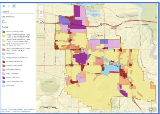
Figure 3. An example ArcGIS online web application displaying color-coded zoning within a city boundary ... 17
Figure 4. Local roads and land features displayed in QGIS... 18
Figure 5. A two-story home rendered in Sketchup ... 19
Figure 6. Sample Planning Department-Facing Screenshot of the Accela Permit Management System ... 20
Figure 7. Bluebeam Revu for electronic plan review. ... 21
Figure 8. Accela Electronic Plan Review plugin for Adobe Acrobat Pro DC. ... 22
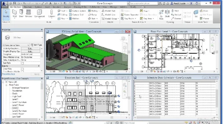
Figure 9. Screenshot demonstrating features of Autodesk's BIM design program REVIT ... 23
Figure 10. Screenshot from Symbium's online platform for determining legal compliance for an accessory dwelling unit (ADU). ... 25
Figure 11. A still from architecture and design software company Autodesk’s promotional video on the benefits of BIM-GIS integration. ... 26
Figure 12. Framework for the future of planning software. ... 87
Figure 13. Conceptual illustration of the elements of a planning data model ... 134
Figure 14. Framework for data-integration and continuous urban asset management through the building life cycle ... 135
Executive Summary
Software powers the modern urban planning department. However, the majority of academic attention on software in the planning profession has focused on highly specialized land use models, ignoring the importance of common applications that most planners rely upon
throughout their workdays. For example, email’s impact on planning has gone largely
undiscussed in the literature despite its role as one of the most commonly used software by planners. This report has a twofold purpose: 1) create a protocol for interviewing planners about the software they use routinely; 2) synthesize needs and expectations of planners
gathered during interviews with relevant literature on planning technologies into a framework for the future of planning software. The framework presented in this report unifies, for the first time, disparate fields of research on software related to urban planning into a single set of guidelines for developing the future of software for public agencies. This framework provides a research agenda for urban planning software systems that mutually strengthen one another, and a valuable conceptual overview of the diverse information systems involved in the planning profession.
Eleven interviews were conducted with mid- and senior-level planners in local governments across Santa Clara County, better known around the world as Silicon Valley. Santa Clara County was selected as the study area for two reasons: well-resourced governments in the area can invest in modern planning software, and to question if the stereotype of the
area’s technological leadership extends to its local governments. Senior-level planners were interviewed in a semi-structured format with the interview adjusted based on a short survey
tracking software, and ArcGIS Online). Key findings from the interviews informing the framework include:
• Planners in local governments in Silicon Valley are transitioning into modern
software tools, like electronic plan review and permit management systems. There is no special technological advantage in Silicon Valley among public agencies.
Planners were eager to fully implement and adopt software features available to them, particularly features that would improve communication about project status with applicants;
• Planners were unafraid of software automation. Limited automation features
available in electronic plan review systems were yet to be fully implemented, and planners embraced the time-saving potential;
• The volume of email burdened interviewees. This draws attention to the significance
of generalized productivity software in the practice of planning;
• Planners had no immediate need for “big data,” despite the recognized importance
of big data in the urban planning technology literature.
Perceptions from planners about the software that they use informed key problems and set goals for the framework developed here. Extensive research into emerging software targeting the construction and engineering trades with relevance to planners, as well as software designed to assist creative knowledge workers, informed the development of the future framework for planning software. Features of the framework include:
• A planning data model that underpins land use codes, development guidelines, and
planning department procedures, providing machine-readable logic that underpins rule-based systems in email, project tracking, permit management, electronic plan review, and staff reports;
• Template-based and data type-aware word processing that encodes standardized
practices for writing documents and requires numeric data be stored and represented as such.
• Electronic plan review systems that assist in checking both objective zoning codes and
subjective design guidelines using generalized adaptable rule language;
• Integrated BIM-GIS supporting both the plan review and permit management process by
organizing and visualizing spatial and physical data about the built environment; and
• Predictable, structured times to respond to email from applicants and the public and
process-integrated calendars that recover time for focusing on long-term planning efforts;
The generalized productivity software that planners have been using for over thirty years is inadequate for the predicted era of big data generated by networked urban
environments. Excel is not designed to support real-time analytics, Word is not designed to assist in describing or associating analytics with textual information, and no application has yet been designed to visualize or organize such data for engaging the public. This framework gives planners and researchers of planning technology insight into the range of software used by planners and develop an innovative class of software fit for stewarding the cities of the coming century.
The primary contribution of this report to the planning literature is the framework for advanced planning software. Future research may be directed towards bridging the literature on software for public outreach (social media or e-government) and planning support systems with the framework. In addition to the framework, this report offers a model protocol for interviewing urban planners about their professional software, encouraging follow-up studies in different institutional settings.
Chapter 1. Introduction
Background
Over the past thirty years, urban planning, like virtually all other professional disciplines, has become mediated by software. Communicating with the public, managing
appointments, analyzing property data – administrative or technical tasks that were once
handled on paper, in passing in the department hallway, or in conversation at the planning desk have largely been computerized. Demands on planners have also increased over the past thirty years as the pace of urban development has intensified. Computers have allowed architects and engineers to produce intricate schematics more quickly, the public has more channels to communicate with planners, and decision-makers expect planners to provide more quantitative data to support their recommendations.
Software shapes the practice of the profession. Email impacts how planners
communicate with the public and elected officials. Permit management systems help planners share the status and condition of urban assets with their colleagues across departments. Electronic plan review systems allow planners to provide clearer, more precise feedback on plan sets sand identify violations of city policy with fewer oversights and in less time. Despite the importance of enterprise software to the urban planning profession, it has largely escaped academic attention.
Planners wear many hats as communicators and analysts.1 The role of communicator is
multifaceted, with planners variously performing as educators, negotiators, and enforcers of the
1Simin Davoudi, “Planning as Practice of Knowing,” Planning Theory 14, no. 3 (2015): 316–31,
municipal code.2 At senior levels, planners may be tasked with defending controversial
recommendations on projects to decision-makers and the public. All planners act as stewards of
their local government’s plans and ordinances, helping the public understand how they can
develop their communities within the limits of the law. These tasks can never be automated out of existence. However, software can automate out certain time-consuming aspects of the
profession that have been inflicted by the rise of computerized communication and design. Planning departments across the United States have undertaken a landmark transition from traditional paper-based plan reviews and permitting processes to digitized systems that partially automate plan set checking and inter-departmental coordination. Where implemented,
these new systems have been adopted and customized to each department’s specific procedures
and local rules, at significant financial cost and expended staff time. During this transition, an entirely new generation of urban information systems has emerged. Scholars anticipate the future growth of urban environments to be driven by vast amounts of diverse types of data
collected with high precision and often in real-time.3 Engineering and construction researchers
have begun developing prototypes and theoretical models that will automate complex analytics of the physical built environment. A new class of software capable of marshalling the data-rich built environment of the future into a coherent body of information that supports public goals for land use has yet to be described. Therefore, it is timely to theorize how the next generation of urban information systems could support the planning profession.
2 Joongsub Kim, What Do Design Reviewers Really Do? Understanding Roles Played by Design Reviewers in Daily
Practice (Springer Nature Switzerland, 2019).
Study Overview
This report examines the wide range of software used by public sector urban planners with the aim of developing an idealized framework for the future of planning software. The research is based on in-depth interviews with a sample of eleven planners in various job titles and levels of seniority from several local governments in Santa Clara County.
Santa Clara County, better known around the world as Silicon Valley, faces peculiar challenges that should make it a subject of interest to planning generally. For example, Cupertino is a mid-sized Silicon Valley city (pop. 60,000), best known for being home to the
headquarters of the world’s most valuable company, Apple, Inc. The planning department faces
an extraordinary range of projects, from mega-structures like Apple Park, to mixed-use development streamlined by California state housing regulations to small home-improvement projects with hand-drawn plan sets. Experiences from planners in these well-resourced local governments may contain insights that could help planners in less well-resourced departments prepare for the software they may eventually acquire. The study sets out to answer two questions:
• Can the everyday tasks and long-term challenges faced by the planning profession be
addressed more effectively through improved software?
• How can the perceptions of planners about the software they use inform new software
tailored to their role as communicators and decision-makers in complex urban settings? Responding to the first question motivates the literature review and interview protocol. The framework developed for this report responds to the second question, incorporating data from the interviews and literature review.
I approached these questions with the following theoretical assumptions about the relationship between urban planners and their software:
1) Planners can express ways that their software is adequate and inadequate;
2) Planners feel that the software they spend the most time in has not improved;
3) Planners find the need to communicate existing data, particularly legal information,
more cumbersome than any lack of data.
The study draws upon semi-structured interviews to capture planners’ perceptions
directly. As discussed in greater detail in the conclusion of this report, this approach comes with several notable limitations. However, it is a pillar of design to understand the needs of the end user. Further, there is some historical interest as many planners are adjusting to the
digitalization of the plan set review process.
The Need for This Study
This report aims to use perceptions from planners in Silicon Valley to outline a practice gap between the profession and its software. The literature on urban planning software
emphasizes planning support systems, what they are and how they can be made to better meet land use forecasting needs. Examples of planning support systems vary widely, from tools designed to enhance walkability4 to better planning for green infrastructure5. Planning support
4Claire Boulange et al., “Improving Planning Analysis and Decision Making: The Development and Application of a
Walkability Planning Support System,” Journal of Transport Geography 69 (May 1, 2018): 129–37, https://doi.org/10.1016/J.JTRANGEO.2018.04.017.
5Martijn Kuller et al., “Building Effective Planning Support Systems for Green Urban Water Infrastructure—
Practitioners’ Perceptions,” Environmental Science and Policy 89, no. June (2018): 153–62, https://doi.org/10.1016/j.envsci.2018.06.011.
systems themselves are not widely adopted6 and characterizing the planning support system as
a major software tool of urban planning ignores the reality of practice. Planners’ perceptions of
their software, which includes familiar programs like Excel and Outlook, do not appear in the literature. A need has been established for research on PSS that focuses on practical
applications, rather than the technologies themselves.7 This report extends this pragmatic,
practice-oriented calling towards the full range of practitioner software. Planners take on diverse roles depending on the needs of their department, but all of these roles are mediated
digitally, resulting in the term “e-planning.”8 The technical burden incurred by software
necessary to run complex models for legally required studies has contributed to the rise of
private policymaking through consultants.9 Capturing perceptions from city staff on how
software affects their range of tasks could reveal fundamental concepts for designing a software platform suited to the complexity of urban planning.
This report focuses on widely used software systems relevant to practitioners. The voices of planners are also rarely heard in the literature,10 and what little attention is paid to
planners’ perceptions of their software is focused on specialized long-range or strategic
planning software (i.e. planning support systems). As the interviews summarized in this report
6Guido Vonk, Stan Geertman, and Paul Schot, “Bottlenecks Blocking Widespread Usage of Planning Support
Systems,” Environment and Planning A 37, no. 5 (May 1, 2005): 909–24, https://doi.org/10.1068/a3712.
7Marco te Brömmelstroet, “Towards a Pragmatic Research Agenda for the PSS Domain,” Transportation Research
Part A: Policy and Practice 104 (October 1, 2017): 77–83, https://doi.org/10.1016/j.tra.2016.05.011.
8Ernest R. Alexander, “‘Planning’ or e-Planning?,” International Journal of E-Planning Research 3, no. 1 (2014): 1–
15, https://doi.org/10.4018/ijepr.2014010101.
9Tyler A. Scott and David P. Carter, “Collaborative Governance or Private Policy Making? When Consultants Matter
More than Participation in Collaborative Environmental Planning,” Journal of Environmental Policy & Planning
7200 (2019): 1–21, https://doi.org/10.1080/1523908X.2019.1566061.
10 Tuna Tasan-Kok et al., “‘Float like a Butterfly, Sting like a Bee’*: Giving Voice to Planning Practitioners,” Planning
clearly indicate, widely used productivity software, particularly email, shapes the experience of the profession much more. Researchers should devote more attention to the holistic interaction between software used by planners to improve urban planning practice. Practitioners might benefit from hearing their concerns expressed in the interviews and recognizing the value of research in overcoming these concerns.
Report Overview
The report proceeds as follows:
Chapter 2 defines critical software in the context of the planning profession, including generic
productivity software such as Microsoft Word and Adobe PDF and specialized software such as electronic plan review. A brief introduction to emerging software is also provided.
Chapter 3 presents an overview of the academic literature on the role of software in the
planning profession currently, and the potential for planning software, particularly stemming
from “Smart city” discourse.
Chapter 4 describes the interview methodology.
Chapter 5 summarizes the interview findings.
Chapter 6 presents the framework for the future of planning software in light of planners’
perceptions of their current software.
Chapter 7 reflects on the interview protocol developed for this report, discusses limitations of
Chapter 2. The Tools of Planning in the Modern
Planning Department
Substantial scholarly attention has been dedicated to the application of GIS and its potential in urban planning. In reality, the practical tools of planning are much broader. This chapter provides an overview of the range of software used in modern planning departments,
defining them in the context of their use. An overview of the concepts of “small data” and
emergent “big data” is also provided. These definitions form the background for concepts
discussed in the literature review and interview findings chapters of this report. More
importantly, this chapter offers a panoramic view of the information technology used in urban planning.
Although readers may be familiar with software discussed in this chapter, such as Microsoft Word and ESRI ArcMap, descriptions are provided in the context of their use for planners as public communicators, advisors to decisionmakers, and administrators. The
productivity effects of software on planners remains understudied, despite the essential role of desktop software in the routine tasks and long-term projects of planners. Similarly, the
diversity, quality, and management of data used in planning departments remains
understudied, despite the growing body of literature on smart cities and government decision making driven by urban big data. The latter portion of this chapter describes what traditional
“small data” is, how it is used in planning and administration, and the potential for “big data”
in urban development.
Supporting technologies, operating systems, browsers, and server infrastructure, have been omitted since they are not directly used for planning. While planners certainly use
browsers to access information, planning work is not done directly using these tools.
Differences between one browser or another would not impact their work. Supporting server hardware and backend data infrastructure constrains the technology available to planners; reviewing the literature on hardware supporting public administration requires technical treatment outside of the scope of this report.
Types of Planning Software
Generalized Software
Collaboration and Project Management
Urban planning requires the input of department colleagues, members of the public, private sector counterparts, and public officials for the design of plans and written statements.11
This section presents software in alphabetical order.
Calendars
Calendars record staff schedules, task timelines, and time-critical project-management information. Important dates relevant to a department may be managed by an administrator and subscribed to by effected staff. Individuals may add their own tasks and timelines to the calendar at their workstation.
Example applications: Microsoft Outlook, Google Calendar, Apple iCal
Email is a popular form of exchanging text, pictures, and documents over the Internet through personally registered accounts. One of the defining features of email is that it is a form of asynchronous communication, allowing responses between participants in a conversation at various times. By comparison, traditional telephone calls are a form of synchronous
communication, where a conversation happens in real time. A widely-cited 2004 diary study of information worker activities found that 23% of all tasks performed by information workers during the day were related to email.12 Riggs & Gordon (2017) found in their survey study of
the mobile applications used by California planners that that 99% of planners used email, 94% used mobile email, and 82% used email most often out of all mobile applications, even more
than search engines.13 Emails are known to be distracting to task performance, with regular
interruptions contributing to work-related stress and a higher potential for angrily-toned email messages.14 One recent study has identified a potential for re-organizing the email interface
around separating messages with tasks (messages that need replies) and information (notifications), and integrating virtual activities with real environments.15
Example applications: Microsoft Outlook, Gmail, Apple Mail
12 Mary Czerwinski, Eric Horvitz, and Susan Wilhite, “A Diary Study of Task Switching and Interruptions,” in CHI
Conference on Human Factors in Computing Systems Proceedings (CHI 2004), April 24-29, 2004, Vienna, Austria., vol. 6, 2004, 175–82, https://doi.org/10.1145/985692.985715.
13William Riggs and Kayla Gordon, “How Is Mobile Technology Changing City Planning? Developing a Taxonomy
for the Future,” Environment and Planning B: Urban Analytics and City Science 44, no. 1 (2017): 100–119, https://doi.org/10.1177/0265813515610337.
14Fatema Akbar et al., “Email Makes You Sweat : Examining Email Interruptions and Stress with Thermal Imaging,”
in CHI Conference on Human Factors in Computing Systems Proceedings (CHI 2019), May 4 - 9, 2019, Glasgow, Scotland UK., 2019, 1–14.
15Thomas Bertrand, Laurent Moccozet, and Jean Henry Morin, “Augmented Human-Workplace Interaction:
Revisiting Email,” Information Visualisation - Biomedical Visualization, Visualisation on Built and Rural Environments and Geometric Modelling and Imaging, IV 2018, 2018, 194–97,
Instant Messaging
Instant messaging is intended for short-form communications between collaborators who may have information or supportive advice. Instant messaging can happen on a networked application on a personal computer or through a cellular network, typically called text
messaging. Staff members may communicate with the public through instant messaging, and these messages are considered part of the public record.
Example applications: Slack, Google Chat, Apple iMessage
Shared Cloud Drive
A shared cloud drive is a remotely managed, virtually limitless capacity file system (a cloud drive) that allows collaborative access and manipulation of many large files. Staff and administrators may use shared cloud drives to work collaboratively on complex documents or presentations. The public may use a shared cloud drive to access template administrative documents, administrative records, scans of paper documents, and open data.
Example applications: Dropbox, Box, OneDrive
Teleconferencing
Teleconferencing systems facilitate simultaneous multi-party meetings, similar to traditional phoneline teleconferencing lines, with video or computer screensharing and high-clarity voice-over-Internet Protocol audio transmission. Teleconferencing systems support ongoing cooperation on complex projects with internal and external stakeholders.
Productivity Software
Urban planning requires thorough written examination of urban policy issues and the recording of findings related to decisions on urban development. The same productivity software used in many professions for the presentation of text and imagery and the manipulation of quantitative and qualitative data have seen nearly universal use in the planning profession.
Word Processing
Word processors store and format text and allow for the basic manipulation and positioning of supplemental visual material, such as pictures or tables. According to Yeh (1988), word processors are highly applicable to the core tasks of urban planning, which in his framework of urban planning includes ordinance enforcement and liaison with the public and
decisionmakers.16 Three types of routinely created planning documents, internal memos on
practices, staff reports, and draft long-range plans, are all developed on word processors. The basic services provided by the word processors, storing and formatting text for presentation, have changed little since the mid-1990s.
Example applications: Microsoft Word, Google Docs, LibreOffice Writer
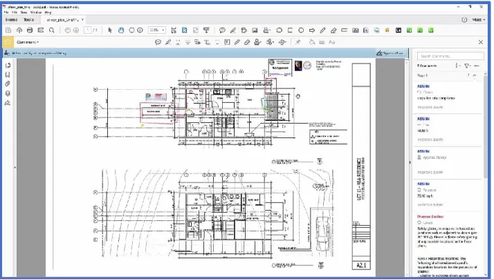
PDF Readers
PDF readers display and may allow annotation on digital documents that use the PDF standard. Plan sets, policy documents, and informational materials may be distributed as PDFs.
16 A Gar-On Yeh, “Microcomputers in Urban Planning: Applications, Constraints, and Impacts,” Environment &
Broadly, there are two types of PDF readers: free PDF readers with basic feature sets, and premium PDF readers with suites of tools for annotating and revising a range of documents.
Planners may use premium PDF readers to alter documents rather a desktop publishing
tool or word processor. The Principal Planner/Planning Manager of Cupertino’s civil deposition in the referendum on the Vallco Project Piu describes how an accident using Acrobat Pro
impacted the General Plan resolution reviewed by the City Council.17
Many electronic plan review protocols accept PDFs as their intake format. Planners may use comment tools available in free PDF readers with limited feature sets to annotate submitted plans. Planners with premium PDF readers may draw on the document in addition to
commenting. Specialized electronic plan review systems (described below) integrate PDF readers with features that automate some of the checks that a planner might manually make on a plan set.
Example applications: Adobe Reader DC, Adobe Acrobat Pro DC, Microsoft Edge PDF Viewer
Spreadsheets
Modern spreadsheets store numeric and text data as a table and can perform
mathematical calculations, statistical analyses and simple modelling. For planners, most of the data stored in spreadsheets is administrative, originating from a census or other periodically updated descriptive records.18 Spreadsheets may be used to track the status of physical assets,
for example whether a property is vacant or not, or the last pavement date of a road segment. Spreadsheets may also be used to develop special tools. For example, San José makes public its
17“Referendum Petition Against City of Cupertino Resolution No. 18-085: Declaration of Piu Ghosh” (Superior Court
of the State of California County of Santa Clara, 2019).
Excel spreadsheet-based tool to model the VMT impacts of new construction based on an address input and user-selected variables related to transportation impacts.19 Over time, these
spreadsheets expand and evolve. Spreadsheets expand when more data is added, either by the digitization of paper records or findings about physical assets from public works officials.
Spreadsheets evolve when technical guidance on formulas used to interpret the data changes20,
or when there is a mandate to interpret the data differently, such as the switch from Level of Service to Vehicle Miles Traveled to determine environmental impacts due to development. Spreadsheets are known to be error prone. Errors in spreadsheets have been found to contribute to incorrect decisions made in enterprise and the public sector.21
Spreadsheet software implement a limited set of instructions for the creation of formulas and a programming language for the creation of more complex models and tools to manipulate data entered into the spreadsheet. Microsoft Excel, the most popular spreadsheet application uses Visual Basic for Applications (VBA) as its programming language. VBA has notable flaws that have led to persistent errors in spreadsheets.22 Researchers have been
developing new paradigms for more easily maintainable spreadsheets,23 automated
19City of San Jose, “City of San Jose VMT Evaluation Tool,” last updated 2/28/19. Retrieved from:
http://www.sanjoseca.gov/DocumentCenter/View/75866.
20Bas Jansen, Felienne Hermans, and Edwin Tazelaar, “Detecting and Predicting Evolution in Spreadsheets-a Case
Study in an Energy Network Company,” Proceedings - 2018 IEEE International Conference on Software Maintenance and Evolution, ICSME 2018, 2018, 645, https://doi.org/10.1109/ICSME.2018.00074.
21Stephen G. Powell, Kenneth R. Baker, and Barry Lawson, “Impact of Errors in Operational Spreadsheets,” Decision
Support Systems 47, no. 2 (2009): 126–32, https://doi.org/10.1016/j.dss.2009.02.002.
22Sohon Roy, Arie Van Deursen, and Felienne Hermans, “Perceived Relevance of Automatic Code Inspection in End
-User Development : A Study on VBA,” in Evaluation and Assessment in Software Engineering (EASE ’19), April 15–
17, 2019, Copenhagen, Denmark. (New York, NY, USA: ACM, 2019), 1–10.
23Patrick Koch, “Now You’re Thinking With Structures: A Concept for Structure-Based Interactions with
Spreadsheets,” in Proceedings of the 5th International Workshop on Software Engineering Methods in Spreadsheets,
visualization tools for spreadsheet data24, and spreadsheet-word processor hybrids for
data-intensive documents25.
Example applications: Microsoft Excel, Google Sheets
Presentation Design
Presentation design software organizes text and supplementary graphics using the format of the slideshow to communicate information on a topic. Presentations by staff on new ordinances, policies or major projects are often supported by a slideshow.
Example applications: Microsoft PowerPoint, Apple Keynote, Prezi
Desktop Publishing
Desktop publishing software combines basic word processing with highly customizable what-you-see-is-what-you-get page design capabilities for handouts, fliers, reports, and other visually appealing informational documents. Planners may use desktop publishing software to create materials about new ordinances, major projects, or referenda. Certain large-format materials, particularly public notification posters for upcoming projects, may be designed in a desktop publishing software or a graphics editing software.
Example applications: Microsoft Publisher, Adobe InDesign
24Yun Wang et al., “DataShot: Automatic Generation of Fact Sheets from Tabular Data,” IEEE Transactions on
Visualization and Computer Graphics - Early Access, 2019, https://doi.org/10.1109/tvcg.2019.2934398.
Graphics Editing
Graphics editing software directly manipulate computer representations of visual images. Maps may require minor touch-ups, modifications, or annotations that are easier for a planner to make in a graphics editing software than in the mapping software itself. Graphics editing software may occasionally be used to produce visual aids for presentation to the public.
Example applications: Adobe Illustrator (vector graphics), Adobe Photoshop (pixel graphics)
Generalized Software for Land Use Management Code and Ordinance Archives
Code and ordinance archives are websites, not standalone desktop software. Code and
ordinance archives serve as a repository for a local government’s legal code. Legal resource
hosting is not interactive. Rather, planners (and the public) access online archives through their web browser. Urban planners refer to development codes and ordinances that control the rights of way, zoning, subdivisions and other divisions of land, business regulation, among many other code types. Legal resources are typically stored as text with hyperlinks to other relevant parts of the document. The ability to perform a search for text on the web page makes
browsing the legal resource more convenient than using a local government’s official paper
copy of the legal code, which is technically the binding record of local law.
Geographic Information Systems (GIS)
Figure 1. Palo Alto's Municipal Code of Ordinances online, hosted by American Legal Publishing. Source: City of Palo Alto,
“City of Palo Alto Municipal Code,” https://www.amlegal.com/codes/client/palo-alto_ca/ (Accessed October 16, 2019).
Figure 2. San Jose's Municipal Code of Ordinances online, hosted by MuniCode. Source: City of San Jose, “City of San Jose Municipal Code,” https://library.municode.com/ca/san_jose/codes/code_of_ordinances (Accessed October 16, 2019).
GIS is a locational data visualization, analysis, and manipulation software. Uses for GIS are diverse, since planning departments are responsible for effective long-term land use. Generally, GIS is used to display demographic or administrative data on a map to aid situation understanding or decision making. Planners and the public may use an online GIS tool for retrieval of basic physical or codified attributes about a city parcel, such as its general plan designation, zoned density, or proximity to coastal resources. GIS may also be used to represent possible land use under certain conditions for planning purposes.
Example applications: ESRI ArcGIS Online, QuantumGIS (QGIS), Pitney Bowes MapInfo.
Figure 3. An example ArcGIS online web application displaying color-coded zoning within a city boundary. Users can enter an address or click on a zone for more detailed information. Source: ESRI, “Learn ArcGIS,”
https://learn.arcgis.com/en/projects/evaluate-locations-for-mixed-use-development/lessons/prepare-andvisualize-data.htm (accessed November 26, 2019
Interactive Land Use Visualization
Land use visualization software organizes satellite and terrestrial photography into searchable panoramas. Planners use interactive land use visualizations to quickly assess site context without physically visiting the parcel. Interactive land use visualizations are typically used alongside electronic plan review and permit management systems, both described below.
Example applications: Google StreetView, Google Earth
Figure 4. Local roads and land features displayed in QGIS. QGIS, “About QGIS,”
Architectural Mockup
Architectural mockup software produces superficial virtual representations of structures, unlike computer automated design software that produce precisely detailed, functional models of structures. Planners versed in architectural mockup software may use this tool to
demonstrate a design concept or plan set review feedback, or a visualize a proposed project for decision-makers.
Example applications: SketchUp, Sweet Home 3D
Specialized Software
This section provides an overview of software intended for planners and their colleagues in building and public safety departments. Some of the software covered in this section are feature subsets of tools designed for architecture, construction, and engineering trades.
Figure 5. A two-story home rendered in Sketchup.Source: StackExchange,
https://graphicdesign.stackexchange.com/questions/28761/painlessly-export-from-sketchup-pro-2013-to-cinema4d-r15-studio (accessed November 27, 2019).
Permit Management Systems
Permit management systems organize and track information related to projects in development, such as supporting documentation, renewal dates, fees, and due dates. Many local governments adopt permit management systems for two key reasons: 1) centralized tracking and coordination of permitting data across planning, building, and fire, and other public works departments; 2) a web portal that closely reflects the real status of permits as they processed internally. Most permit management systems are extensively customized by IT staff and senior planners to facilitate local procedures for validating applications through a planning department. Many local governments integrate their permit management system with their GIS system for quick contextualization of available information on projects.
Example Applications: TRAKiT, Accela, Amanda
Figure 6. Sample Planning Department-Facing Screenshot of the Accela Permit Management System. Source: Accela,
“Understanding the Civic Console Platform,”
Electronic Plan Review (EPR) Software
Critically, EPR software facilitates parallel review of plan set documents by staff in different departments (i.e. planning, building, fire, and public works). Planners and building department officials use EPR to track comments and changes to plan sets throughout the application review process. Interoperability of data between asset inspection management software and electronic plan review is a desirable feature, since the functions of these software
overlap in managing building applications.26 Some asset inspection applications include
extensions to specially manage Electronic Plan Review.
Example Applications: ProjectDox, BlueBeam, idtPlans
26Avolve Software, “Interoperability” (n.d.). Retrieved from: https://www.avolvesoftware.com/interoperability/
Figure 7. Bluebeam Revu for electronic plan review. The bubble indicates an area with a comment. Source: TrustRadius,
“Product: Bluebeam Revu,” https://media.trustradius.com/product-screenshots/gr/2u/TNOM63AWNS9Q.jpeg (accessed November 27, 2019).
Emerging Technologies
Building Information Modeling (BIM)
BIM is not a class of software itself, rather it a process involving Computer Assisted Design software for architecture, construction, and engineering that embeds information about a physical structure in a digital form. Broadly, the result of BIM is a data-rich representation (model) of the physical and functional characteristics of the structure that it represents. For municipalities, one of the primary advantages of receiving BIM submissions over 2D plan sets is more extensive automated code compliance checking through model-based inspections. BIM primarily benefits building departments, since they evaluate the technical conditions and performance of a structure that BIM can efficiently store and potentially simulate. Planning
Figure 8. Accela Electronic Plan Review plugin for Adobe Acrobat Pro DC. Source:Accela Demo Library, “Permit Plan Review Using Accela Civic Platform and Adobe Acrobat Pro” https://vimeo.com/195533362 (accessed November 27, 2019).
departments can evaluate a flattened 3D model as they would a 2D plan set, with the benefit of a 3D view for a better sense of massing and other salient design features.
Only a few governments worldwide have implemented a transition from 2D digital plan set intake to BIM. Singapore mandated the use of BIM for all new construction projects in 2015. Singapore has implemented partial automated building code compliance checking and basic checks for compatibility with land use type and allowable floor area ratio in that land use type. In the United States, as of October 2019, no local government has yet adopted BIM for plan review.27
27Kamellia Shahi, Brenda Y. McCabe, and Arash Shahi, “Framework for Automated Model-Based e-Permitting
System for Municipal Jurisdictions,” Journal of Management in Engineering 35, no. 6 (2019): 3–5, https://doi.org/10.1061/(asce)me.1943-5479.0000712.
Figure 9. Screenshot demonstrating features of Autodesk's BIM design program REVIT. Source: LinkedInLearning
(formerly Lynda), “Introducing building information modeling (BIM): Revit Architecture 2016 Essential Training,”
Machine-Readable Policies, Ordinances, Building, and Zoning Codes
Policies, ordinances, building codes, zoning codes exist as plain text in a document unless they are translated into a machine-readable format. Research has primarily focused on relevance to building, fire and energy codes, which are more easily translated into formal logic, than context-dependent planning ordinances and design criteria. Implementing
machine-readable forms of a local government’s policies and enforceable development standards makes
introspective policies aware of overlapping or contradictory effects and automated code compliance possible.
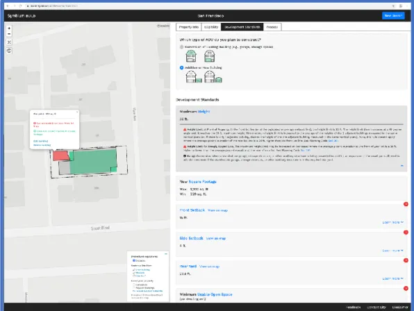
One company, Symbium, has begun developing machine-readable forms of objective development standards for a few California jurisdictions. For example, Symbium provides automated online preliminary zoning review of accessory dwelling units for San José, San
Francisco, Los Angeles, and San Mateo County.28
GIS Integrated with BIM
Academic and industry researchers have proposed the integration of GIS with BIM to provide environmental (macro-level) context to project-specific (micro-level) BIM information.
The promise of BIM/GIS integration is a “transformative” tool to analyze spatial information through the full scale of the built environment, making project planning “more efficient,
rational, and standardized.”29 BIM/GIS integration is considered an essential technology for
29Hao Wang, Yisha Pan, and Xiaochun Luo, “Integration of BIM and GIS in Sustainable Built Environment : A
Review and Bibliometric Analysis,” Automation in Construction 103 (2019): 42,
https://doi.org/10.1016/j.autcon.2019.03.005.
Figure 10. Screenshot from Symbium's online platform for determining legal compliance for an accessory dwelling unit (ADU). Symbium proposes to convert a city's legal code into machine-readable rules. Source: Symbium, “Symbium Build: San Francisco,” https://assets.the-atlas.com/project_images/65c4ef57af600c1caf62dcc9646ab432.png (accessed November 17, 2019).
more complete automation of the project review process.30 However, the broader application of
BIM/GIS integration to urban governance has not been extensively researched, and there have been few real-world applications. Realizing the potential of BIM/GIS integration involves capturing data about existing buildings in BIM and developing BIM-compatible data formats for relevant information outside of the scope of the construction industry, such as landscape water consumption.31
30Shahi, McCabe, and Shahi, “Framework for Automated Model-Based e-Permitting System for Municipal
Jurisdictions.”
31Wang, Pan, and Luo, “Integration of BIM and GIS in Sustainable Built Environment : A Review and Bibliometric
Analysis,” 49.
Figure 11. A still from architecture and design software company Autodesk’s promotional video on the
benefits of BIM-GIS integration. Source: Autodesk, “Uses for BIM-GIS Integration,” https://www.viewstream-media.com/autodesk/bim-gis-integration/08/ (accessed November 27, 2019).
Chapter Takeaways
This chapter provided an overview of the types of software used in modern planning departments. This includes general productivity software, such as Microsoft Word, Excel, and Outlook, and specialized software for planners, such as electronic plan review and permit management systems. Many planners take advantage of spatial visualization tools, such as Google StreetView and Google Earth, to determine site context. Emerging trends in planning software technology include integrating Building Information Modeling (BIM) with Geographic Information Systems (BIM/GIS integrations) and encoding objective regulatory ordinances in machine-readable forms to automate and increase the speed of administrative decision-making.
Chapter 3. Literature Review: Present and
Future Uses for Software and Data in Urban
Planning
The purpose of this literature review is twofold: 1) provide a foundation of knowledge on the role of software and data in urban planning as a public sector entity; and 2) identify emerging theoretical understandings for the future role of software and data in the urban planning profession. For key terms and databases used in the literature review, refer to Appendix A: Literature Review Search Parameters. This chapter is divided in two parts:
Software and Data.
Software
In 1987, planning theorist A. Gar-On Yeh divided software packages for urban planning into two categories: generalized and specialized.32 Yeh predicted that the creation of specialized
software would be slow, since the relatively small size of the planning field meant that the market for specialized software would be small. The review of the literature presented here follows the same two-part division: 1) generalized software in planning; and 2) planning specific software.
32 A Gar-On Yeh, “Microcomputers in Urban Planning: Applications, Constraints, and Impacts,” Environment &
Generalized Software in Planning
Generalized software in planning has received little attention since the late 1980s when computerized systems were affordable to most planning departments. Only one comprehensive review of the role of generalized software appears in the urban planning literature,
“Microcomputers in Urban Planning: Applications, Constraints, and Impacts” (1987) by the
aforementioned A. Gar-On Yeh. In this review of the early literature on software in planning,
Yeh identifies generalized “software packages” used in planning, treating word processing and
spreadsheet programs in detail. Of the “commonly-used” packages Yeh lists for both word
processing and spreadsheet production, only Word and Excel are still maintained.33 In an
analysis of the usefulness of generalized microcomputer functions to the planning profession,
Yeh determines that word processing is the “most applicable” to the typology of tasks used in W. L. Whited’s 1982 APA report on the role of microcomputers in planning. Computer graphics
are found to be the second-most applicable – not computer mapping, which is found to be
equally applicable to programmatic modelling. GIS scholar and planning practitioner Richard
Klosterman, writing in 1998, more than a decade after the publication of Yeh’s article, cited
only Yeh as providing an overview of the function of software in planning.34
Since the 1990s, the study of generalized software within planning has shifted to
collaborative, networked software. Robert Laurini’s book Information Systems in Urban Planning
(2001) describes urban planning applications for collaboration tools, such as email and teleconferencing software. Generally, these collaboration tools expand computers from
33 Yeh, 245.
34R E Klosterman, “Computer Applications in Planning,” Environment and Planning B: Planning and Design
cartographic or database systems to enablers of communication, either by face, voice, or text
over simultaneous or asynchronous timeframes.35To the author’s knowledge, there has not
been a descriptive study of how collaboration software are used within urban planning
departments, and whether or not they improve communications internally, with the public, or with policy makers. Riggs and Gordon (2017) expanded the study of collaboration software from the desktop to include smartphone-based apps. Their study, a survey of California planners assumed to be representative of planning departments nationwide, found that nearly 40% of planning departments had become entirely dependent on Internet technology. The majority of uses involved email and search engine use, with Google Earth, Dropbox, and
note-taking apps as commonly used mobile applications.36 This continued reliance on generic
software confirms Yeh’s prediction three decades later. Riggs and Gordon do not cite any
precedent in the literature for assuming a sample of California is representative of national trends, suggesting that further surveys are necessary to support the findings of this study.
Despite the widespread recognition of word processing and spreadsheets as important computer applications within the planning profession, there are notable gaps in the planning
technology literature about these two types of software. To the author’s knowledge, no study
has directly examined the role of word processing in urban planning departments. A search on
the SJSU Articles database for the subjects “Urban Planning” and “Word Processing” yields no
results. (A similar search for subjects “Urban Planning” and “GIS,” which is less commonly used
by the typical urban planner, yields many results.) Again, to the author’s knowledge, no study
35 Robert Laurini, Information Systems for Urban Planning (London: Taylor & Francis, 2001), 221-233.
36William Riggs and Kayla Gordon, “How Is Mobile Technology Changing City Planning? Developing a Taxonomy
has directly evaluated the role or function of the spreadsheet within the planning department. Numerous studies discuss the importance of spreadsheets as containers for spatial data useful in GIS analysis or land use modeling, but there is apparently no descriptive or qualitative study in the literature observing the use of spreadsheets in the planning department. There are other gaps in the literature on the role of generalized software in planning departments. The role of email and other collaboration software, as well as legal databases used in the planning context to manage ordinances, are unstudied.
Public participation-specific technologies, such as social media and community message boards, have been excluded from this review despite their recognized importance to public sector planning. A Delphi study of academics and government officials based in Western Europe, Canada, and the United States conducted by Anthopolous and Reddick found that
urban planning was deemed un-important in the development of smart cities. Rather, citizen
participation was found to be more important.37 This echoes a sentiment by Laurini, who wrote
in the preface to his analysis of computers in urban planning that, “Computers can help city -dwellers to extend their freedom, to impose their views to urban planners, to share their
opinions about the future.”38 Ongoing public engagement mediated by specially designed
software remains too limited in professional practice to be a subject of this report. For two decades, email has been the primary software used for public engagement, with its continued
prominence indicated in Riggs and Gordon’s study.
37 Riggs and Gordon, 110.
Planning-Specific Software
Goodspeed (2016), in his systematic review of planning-specific software as an aid to planners as servants of the public interest, found four major software types in the literature:
urban modeling, GIS, Planning Support Systems (PSS), and urban informatics.39 Anthopolous
and Reddick (2016), in their systematic literature review of planning-specific technologies involved in the development of smart cities, identified three software types: advanced GIS models, urban informatics, and urban management-centric databases. Anthopolous and
Reddick have combined GIS and PSS into “advanced GIS models.” All four of these systems are
used by planning departments to assist policy making by modeling the effects of sprawl,
economic development, city retrofitting, and land use changes.40 Neither Goodspeed nor
Anthopolous et al. provide descriptive context for how widely used these technologies are, although the extensive study of these four system types in the planning literature suggests their broad relevance to planners globally. A selection of the literature on the presence of GIS and PSS in urban planning offices follows.
GIS in Urban Planning
The literature surrounding the potential uses of GIS in urban planning is vast, but the literature examining the use of GIS in actual professional contexts is relatively sparse. Alrwais et al. (2016) conducted a survey of Southern California cities on their GIS use. Some cities were staffed with GIS divisions responsible for maintaining developing, maintaining, and updating
39Robert Goodspeed, “Digital Knowledge Technologies in Planning Practice: From Black Boxes to Media for
Collaborative Inquiry,” Planning Theory and Practice 17, no. 4 (2016): 580.
40Leonidas G. Anthopoulos and Christopher G. Reddick, “Understanding Electronic Government Research and Smart
key municipal maps and data with spatial attributes. They observed that cities without a GIS
division were in a ‘no-growth’ mode or had not seen an advancement in their use of GIS. Only
the extent that GIS was used within the planning department (“GIS maturity”), more than staff
experience or a GIS evangelist on staff, was strongly associated with perceived value.Some
cities were found to rely on only a single employee to maintain their entire GIS department.41
Vishkaie et al. (2014), while focused on the potential for GIS and CAD to be combined in a public participation tool, interviewed a group of ten planners and academics about their experiences with both software types. Most participants mentioned that mapping, data management activities such as data acquisition and assembling data sets and developing modelling tools are the most challenging GIS tasks in their jobs.42Vishkaie et al.’s findings are
anecdotal, but the same difficulties and barriers to use are reflected in the survey by Alrwais et al. Additionally, Vishkaie et al. note that, while a larger, multi-city, international sample would have provided greater confidence in the findings, the small sample in their ethnographic
approach still generated a large quantity of data, sufficient to develop concepts and context.43
Planning Support Systems
Planning Support Systems (PSS) are the definitive planning-specific software, yet adoption by planning departments is rare44, and the bulk of the literature focuses on potential
or theoretical applications. Pelzer et al. (2015) found in their review of PSS literature that the
41O. Alrwais et al., “An Organizational Perspective on GIS Payoffs for the Public Sector: Is Usage the Missing Link?,”
AMCIS 2016: Surfing the IT Innovation Wave - 22nd Americas Conference on Information Systems (2016): 8.
42 Rojin Vishkaie, Richard Levy, and Anthony Tang, “Urban Planning Process: Can Technology Enhance Participatory
Communication?,” Urban Planning and Design Research 2 (2014): 24.
43 Vishkaie, Levy, and Tang, 22.
44Patrizia Russo et al., “Adoption and Use of Software in Land Use Planning Practice: A Multiple-Country Study,”
usefulness of this type of software had only been observed quasi-experimentally, with the earliest study dating back only to 2013.45Pelzer et al.’s study applied a theoretical framework
for “task-technology fit” to eight case studies from Dutch cities, with four case studies explored
in detail. Directly, PSS served to facilitate communication between planners, stakeholders in a given project, and decision makers. Indirectly, PSS served to bring actors who were not used to talking to each other to physically stand around a table and collaborate, suggesting one indirect benefit. This act of standing around a table illustrates the limitations to this study – the PSS studied here (MapTable) used a tabletop displaying a digital map, which is unique among
PSS.46 Klosterman (1998) found that spreadsheets were by far the most used software for urban
modelling,47 twenty years later this continues to be true, with a relatively small amount of
planning-specific modelling conducted within PSS.
Notable Absences in the Literature on Planning-Specific Software
There are significant gaps in the literature on urban management-centric software. A Google Scholar search for Magnet municipal management software yields zero results.
ProjectDox, an electronic plan review software by the company Avolve, is also absent from the literature. Both of software products are widely used nationally, yet it appears that no
descriptive or qualitative research has been conducted to examine the role of these software types within planning or development processes. Klosterman (1998) notes that the emphasis for
planning-specific software has been on short-term management and code enforcement.48 The
45Peter Pelzer et al., “Planning Support Systems and Task-Technology Fit: A Comparative Case Study,” Applied
Spatial Analysis and Policy 8, no. 2 (2015): 156, https://doi.org/10.1007/s12061-015-9135-5.
46 Pelzer et al., 170–75.
47Klosterman, “Computer Applications in Planning”, 33 48 Klosterman, 34.
profession-specific software mentioned by Klosterman does not appear elsewhere in the literature; an empirical evaluation of the effectiveness of these software products would have been relevant to this report.
Data
To provide a grounding in the wide variety of data used in public sector urban planning, data is broken up into three components: 1) conventional data, or traditional data used for administration and physical resource inventory (e.g. parcel tax income, general plan designations, water quality indicators); 2) big data, used to model and predict general
behaviors; and 3) open data. A fourth sub-section summarizes the literature on the practical realities of data: data mismanagement, changes in public sector practice due to digitalization, and the presentation of data by staff to public officials through staff reports. Rather than describe administrative functions or technical uses for big data in the public sector, this review emphasized literature on current use of data in the public sector with a scholarly eye towards greater usefulness for public sector service.
Conventional Data
Christodoulou et al. (2018) conducted a systematic review of literature on data usage and innovation derived from data used in the public sector. Three categories of uses for data-driven administrations were identified: innovation, transparency (open data), and efficiency. It was clear from the literature that the proliferation of data has improved administrative
efficiency in almost every case. Data also poses four types of challenges: cultural and political barriers to use, technical obstacles, privacy and security issues, and efficient data
management.49 The majority of data remains unstructured, as text, audio files, or photos, or
other forms structured (tagged) for machine-readability. Supporting the purpose of this report, the researchers found that the user experience of data management should be further
examined.50
Gil-Garcia & Ku (2018) performed an in-depth case study on data collection used in a single mid-size city government in New York state. They found that much of the data in local governments was socially constructed, rather than simply mechanically produced. Here, the social construction of data entails the collection of data affected by division of labor, forms of
work processes, human factors such as leadership or employees’ perceptions, and events
happening external to the administration. Gil-Garcia & Ku note that a large portion of the data collected and created in local governments are non-digital. 51 This finding in conjunction with
Christodolou et al. (2018)’s observation that the majority of government data remains
unstructured suggests there are large quantities of machine-inaccessible conventional data. Gil-Garcia & Ku are explicit about the limitations of the single-city focus of their study hindering generalizability and the incidental fact that most of the interviewees participated in the same administrative projects52, raising doubts on the theoretical value of their qualitative findings.
49Paraskevi Christodoulou et al., “Data Makes the Public Sector Go Round,” in EGOV 2018 (Springer International
Publishing, 2018), 221–232, https://doi.org/10.1007/BF03251472.
50 Christodoulou et al., 230.
51 J Ramon Gil-Garcia and Minyoung Ku, “Ready for Data Analytics? Data Collection and Creation in Local
Governments,” in In Proceedings of the 19th Annual International Conference on Digital Government Research
(Delft, The Netherlands: ACM, 2018), 1–10, https://doi.org/10.1145/3209281.3209381.