Pollard, J.A. and Spencer, T. and Brooks, Susan (2018) The interactive
relationship between coastal erosion and flood risk. Progress in Phsyical
Geography , ISSN 0309-1333. (In Press)
Downloaded from:
Usage Guidelines:
Please refer to usage guidelines at or alternatively
The interactive relationship between
coastal erosion and flood risk
JA Pollard
University of Cambridge, UK
T Spencer
University of Cambridge, UK
SM Brooks
University of London, UK
Abstract
Coastal erosion and flooding are hazards that, when combined with facilitative pathways and vulnerable receptors, represent sources of coastal risk. Erosion and flooding risks are often analysed separately owing to complex relationships between driving processes, morphological response and risk receptors. We argue that these risks should be considered jointly and illustrate this through discussion of three ‘expressions’ of this interactive relationship: coastal morphology modifies flood hazard; future flood risk depends on changing shoreline position; and the simultaneous occurrence of erosion–flooding events. Some critical thoughts are offered on the general applicability of these expressions and the implications for coastal risk management policy.
Keywords
Erosion, flooding, future coastal risk management, source-pathway-receptor, coastal morphology
I Introduction
Risks relating to water oversupply (e.g. extreme flood events) and undersupply (e.g. drought) first appeared in the World Economic Forum’s ‘Top 5 Global Risks’ in 2011 and have persisted ever since (World Economic Forum, 2018). These water risks arise from the interaction of socio-economic and environmental forcings. Coastal water risks are poised to be amongst the most severe global impacts, presently up to 75% of coastal regions vulnerable to ‘very large flooding events’ (Rueda et al., 2017). Further-more, there have been assertions of a multipli-cative relationship between sandy beach erosion and sea level rise (Zhang et al., 2004). These
global assessments manifest locally during extreme events such as Superstorm Sandy (US east coast), Typhoon Haiyan (Philippines) and Cyclone Xaver (North West Europe) but also possess a more generic and permanent impres-sion through reports of chronically eroding coastlines (Bird, 1985; EUROSION, 2004) and increasing flood losses (Hallegatte et al., 2013; Kron, 2013; Vitousek et al., 2017).
Corresponding author:
JA Pollard, Coastal Research Unit, Department of Geography, University of Cambridge, Downing Place, Cambridge CB2 3EN, UK.
Email: [email protected]
1–12
Coastal erosion and flooding are hazards which, when combined with facilitative path-ways and vulnerable receptors, represent sources of coastal water risk. Coastal erosion can be defined as net removal of material from one coastal location to another. It is driven by many natural factors include changes in wave energy, sediment supply, global sea level change and regional / local land subsidence (Penland et al., 2005; Wong et al., 2014). Ero-sion results in a changing position of the shore-line, both in the vertical in relation to a particular datum (such as mean high water springs; Taylor et al., 2004) or, in the case of cliffed foreshores, in a migration of lateral posi-tion. Erosion is often accompanied by deposi-tion, and changing shoreline posideposi-tion, elsewhere (e.g. Montreuil and Bullard, 2012), though material may be lost to suspension, solution and offshore below wave base. Coastal flooding is defined as temporary inundation of a terrestrial area that is not normally submerged. Trends contributing to a likely future increase in coastal erosion and flooding risk include: increasing population density (Hanson et al., 2011), asset concentration in coastal areas (Hinkel et al., 2014), accelerating sea level rise (Hay et al., 2015), potential changes to storm surge climate (Bader et al., 2011; Lewis et al., 2014) and declines in sediment supply (Syvitski et al., 2005). Considering these trends, the ability of decision makers to take appropriate (politically salient, publicly acceptable and financially sus-tainable) mitigation and adaptation manage-ment decisions relies critically on knowledge about the functioning of coastal systems and the risks that they present.
In spite of the availability of holistic manage-ment frameworks (e.g. Narayan et al., 2014; Sayers et al., 2002), erosion and flooding risks are often analysed and managed separately owing to the complex relationships between driving processes, morphological response and risk receptors (Dawson et al., 2009). We argue here that these risks should be considered jointly
and illustrate this argument through the discus-sion of three ‘expresdiscus-sions’ of this interactive relationship: coastal morphology modifies flood hazard; future flood risk depends on changing shoreline position; and the simulta-neous occurrence of erosion–flooding events. A final section takes a critical stance towards these expressions, the extent to which they are generally applicable, and the implications for future coastal risk management.
II The interactive relationship
between erosion and flooding risk
The diversity of coastal systems is matched, in equal measure, by both the variety of interven-tions and the policies devised to manage them. Contemporary approaches to coastal hazard assessment and management are unified by the overarching concept of risk. The risk-based approach recognises that it is not cost effective, desirable, or feasible to protect all areas to the same standard, necessitating risk-based meth-odologies to determine which areas require pro-tection and what standard of propro-tection should be afforded. One such risk-based methodology is the source-pathway-response-consequence (SPRC) framework (Holdgate, 1979). This highlights the need for explicit attention to each part of the risk chain. By breaking down coastal risk into ‘sources’ (waves, surge, rain), ‘pathways’ (nearshore bathymetry, shoreline morphology), ‘receptors’ (residential and commercial property, critical infrastructure, people) and ‘consequences’ (flooding, erosion, increased insurance premiums, loss of life), the framework can be used to pinpoint areas con-tributing to overall risk. The SPRC framework is contextualised within a broader ‘flood sys-tem’ which includes global environmental driv-ers such as climate change and policy responses (Evans et al., 2006; Narayan et al., 2012; Sayers et al., 2002; Thorne et al., 2007).
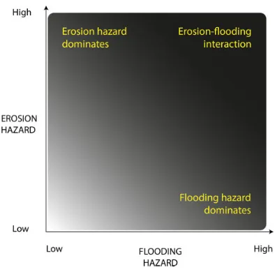
that coastal erosion and flooding should be analysed jointly, because although each repre-sents a stand-alone hazard, they also interact (Figure 1) as follows.
1. Erosional (and depositional) processes modify the nature of the coastal zone with implications for susceptibility to elevated water levels and resultant flood-ing; and
2. The elevated water levels necessary to generate flooding hazard possess the ability to effect erosional (and deposi-tional) change.
This review of coastal erosion and flooding literature directs its attention towards the top right corner of Figure 1, where the combination of high erosion and high flooding hazard, con-fers importance on erosion–flooding interac-tion. In doing so, this paper identifies three ‘expressions’ of the interactive erosion–flood-ing relationship.
Coastal morphology modifies flood hazard. Through its interaction with hydrodynamic conditions (water level,
surge and waves) responsible for flood-ing, coastal morphology can influence flood hazard characteristics (e.g. water height, occurrence of breaching, wave dissipation);
Future flood hazard depends on shore-line position. Since shoreline position determines the natural protection pro-vided by coastal landforms and associ-ated ecosystems seaward of settlements, land-based activities and infrastructure; and
Simultaneous occurrence of erosion-flooding events. Since the extreme weather conditions necessary for flood-ing also drive enhanced sediment trans-port that may permanently alter erosional susceptibility and natural flood defence capabilities of the coastal zone.
Each expression is now elaborated in turn, conveying the varied nature of erosion–flooding interactions and the necessity of addressing these risks jointly to enable effective coastal management.
1 Coastal morphology modifies flood hazard
Coastal morphology refers to co-evolution of the coastal zone and the hydrological, atmo-spheric, terrestrial and anthropogenic processes responsible for contemporary coastal character. The unique combination of processes at any one point in space gives rise to locally-specific morphologies. Additionally, temporal changes in these processes, and their relative impor-tance, means that coastal zone morphology alters through time. Coastal erosion is one example of morphological change and its spatial and temporal manifestations have implications for flood risk.
[image:4.536.63.260.67.262.2]The influence of morphology on spatial var-iation in coastal water levels is well known on low-lying sedimentary coasts (e.g. role of coastal wetlands in surge attenuation in
Louisiana, Gulf coast (e.g. Loder et al., 2009) and Chesapeake Bay, mid-Atlantic coast, USA (Glass et al., 2018). On cliffed coasts, the lin-kages between beach morphology and cliff erosion are important as changes in beach level affect water levels at, and wave energy flux to, the cliff toe, and hence cliff retreat rates, in both hard rock (e.g. SW Peninsula, UK: Earlie et al., 2018) and soft rock (e.g. Suffolk coast, UK: Brooks et al., 2012) settings. The localised nature of these controls was well illustrated following Cyclone Xaver which impacted northwest European coasts in December 2013. High resolution surveying of 250 points along the 45 km barrier coastline of England’s North Norfolk coast revealed variation in the importance of coastal setting in determining maximum water level heights associated with Xaver’s storm surge; at one location, maxi-mum heights varied by 1.91 m between an embayment open to the sea and a compara-tively sheltered pine forest dune slack (Spencer et al., 2015). Such observations may help vali-date models seeking to resolve alongshore var-iations in maximum water heights. For example, Lewis et al. (2011, 2013) developed a storm surge model that incorporates the spa-tial variation in surge peak water levels as observed in local tide gauges. These data were then used to interpolate water levels for loca-tions between tide gauges where observational information was lacking. Due to a lack of storm tide height data between tide gauges, valida-tion relied upon synthetic aperture radar (SAR) imagery from which shoreline position was extracted (Lewis et al., 2013). The value of modelling water level differences between tide gauges was demonstrated by the SAR imagery which recorded differences up to 70 cm between beaches of differing orientation (Lewis et al., 2013). Future work seeks to apply the validated model to predict maximum water height variations for future storm events. At present, predictions of future extreme water levels are characterised by high levels of
uncertainty (Wahl et al., 2017), both because the records themselves are based on single point gauge locations (Brakenridge et al., 2013) and because different statistical methods (annual maxima, r-largest and joint probabil-ity) cope differently with data frequency, length, paucity, and the treatment of tidal and non-tidal components of extreme water levels (Haigh et al., 2010). Extreme water level mod-elling, carefully validated by high spatial res-olution observations, is an important step in quantifying and ultimately reducing this uncertainty.
the coastal management regime to which it has been subjected. This is especially relevant to English coastlines at present given the focus of second-generation shoreline management plans on managed realignment rather than hold the line approaches (Defra, 2006).
Numerous morphological features likely contribute to spatial and temporal water level differences. One area of progress in quantifying the relationship between morphology and water levels is the interaction between hydrodynamics and vegetated intertidal and supratidal plat-forms. Building on work that has established the wave attenuation potential of vegetation under ‘normal’ conditions (Mazda et al., 2006; McI-vor et al., 2012a; Mo¨ller, 1999; Mo¨ller and Spencer, 2002), there is a growing body of work that looks at how habitat types may contribute to surge attenuation (McIvor et al., 2012b; Mo¨ller et al., 2014; Paul et al., 2016; Spencer et al., 2016). This suggests that the return period in a given locality may also change. It is conceiva-ble, for example, that deterioration of a protec-tive saltmarsh results in a 1:100-year event today occurring with greater frequency in the future. Changes to these local return periods are far less predictable than those resulting from sea level rise, and, arguably more important given that flood impacts are ultimately felt at a local scale. Finally, there is evidence from the past for such changes. Thus, for example, and in the context of the evaluation of the return period for superstorm Sandy (Brandon et al., 2014), numerical modelling, sediment core stratigra-phy and historical records all support the argu-ment that the loss of extensive oyster reefs was the most likely cause of increasing storm over-wash sedimentation in the in the outer harbour New York between 1600 and 1800. These results suggest that Staten Island is currently experiencing between 30% and 200% higher wave energy from extreme storms than was the case prior to oyster reef destruction (Brandon et al., 2016).
2 Future flood hazard depends on shoreline
position
Coastal flooding events occur on a timescale of hours to days, and we have already seen that through interaction with shoreline morphology, flood magnitudes can be significantly altered by spatially specific and temporally variable mor-phological change. Therefore, to determine future flooding hazard requires information about the future shoreline that any given flood-generating event will encounter (Grilli et al., 2017).
Numerous studies have analysed historic shoreline change with a view to forecasting future shoreline position (Crowell et al., 1997; Davidson et al., 2017; Moore et al., 2006; Spir-andelli et al., 2016). Brooks and Spencer (2012) evaluated a range of shoreline response models using historical shoreline change data (Brooks and Spencer, 2010) for cliffed sections of the Suffolk coast, England. Modelled cliff retreat rates in response to expected sea level rise acceleration led them to suggest sediment release for this region during the twenty-first century could reach 300,000 m3 a 1 (Brooks and Spencer, 2012). Building on this work, a subsequent study identified decadal periods of accelerated retreat which could be correlated with variations in the North Atlantic Oscillation (NAO), suggesting an important role for storms in the observed change (Brooks and Spencer, 2014; Hurrell, 1995). Elsewhere, establishing robust relationships between forcing variables and morphological responses has proven more challenging, lending weight to the suggestion that certain criteria (high quality datasets, including a quantitative record of sediment budget and large signal:noise ratio) must be sat-isfied to enable informed forecasting (Burning-ham and French, 2013; Esteves et al., 2011; Thieler and Danforth, 1994).
coast where rapid cliff erosion releases large quantities of sediment into the nearshore zone (Dawson et al., 2009). Here, morphological connectivity of the coast, facilitated by long-shore sediment transport, means that this sedi-ment provides a degree of buffering from storm-driven tidal flooding (Dawson et al., 2009). A key challenge going forward sur-rounds attributing specific nearshore sediment accumulations to specific regions of cliff retreat. Even at the location of cliff retreat (and depending on the location of risk receptors), flooding risk will not necessarily increase. In some locations, cliff retreat gave rise to increased cliff height (from 11 m in 1947 to 15.5 m in 2008 at Covehithe), for example (Brooks and Spencer, 2010). Placing such find-ings within the broader flood system, Dawson et al. (2015) advocate an ‘integrated systems approach’, through which it is possible to estab-lish how global climate trends may influence the local relationship between erosion and flooding. More recently, and with a focus on the flood event itself, Grilli et al. (2017) acknowl-edge that a 1:100-year event is equally likely to happen this year and in 100 years and that in each instance, the storm will interact with a dif-ferent shoreline position and morphology. In reality, taking sea level rise into account, the 1:100-year return water level today will occur with greater frequency in the future (Vitousek et al., 2017), lending further support for this kind of shoreline forecasting approach. Dealing specifically with a section of barrier coastline on the US eastern seaboard, Grilli et al. (2017) simulate future shoreline position under a range of sea level scenarios. Furthermore, to provide some indication of morphological change, they consider a series of possible ‘dune states’ (intact, eroded, retreated or drowned) at the point of event impact. Holding sea level rise constant, erosion of the dune ridge is found to result in a 20%increase (compared to a scenario in which dunes remain intact) in the proportion of houses suffering damage during a 1:100-year
flooding event. These figures rise to as high as 55% when sea level rise, dune recession and dune erosion are jointly considered (Grilli et al., 2017). Through inclusion of both reces-sion and dune state, the study indicates that both shoreline position and morphology exert impor-tant influences on flood risk.
forty years, removing a vital protective buffer-ing function and increasbuffer-ing the exposure of onshore settlements and infrastructure to extreme events (Jime´nez et al., 2018).
3 Simultaneous erosion–flooding events
Elevated water levels are required for coastal flooding to occur, particularly where coastal hinterlands are fronted by defence structures. Given that elevated water levels tend to be asso-ciated with high-energy hydrodynamic condi-tions, erosional impacts are likely to coincide with coastal flooding events. This represents an instantaneous alteration to the SPRC framework. Establishing erosion–flooding interactions during these events is especially important given that low frequency, high mag-nitude events can possess disproportionate ero-sive and flooding potential (Callaghan et al., 2009). Phillips (2014) refers to geomorphic state transitions, suggesting the existence of threshold(s) within the geomorphic system that must be surpassed to deliver state change (Schumm, 1973, 1979). An important, albeit largely unanswered, question is how threshold exceedance and resultant state change maps onto coastal erosion and flood risk.
One example of morphological threshold exceedance with implications for flood risk is barrier breaching. Such breaching occurs when the barrier ridge is eroded to such an extent that a new channel is formed between the open-water seaward side and the back-barrier bay (Davis et al., 1989). Breaching events are some-times preceded by or associated with overwash in which sediment is transported from the sea-ward, over the crest, to the landward side (Schwartz, 1975). Breaching and overwash rep-resent a direct pathway through which water flows can propagate, resulting in potentially increased water levels in back-barrier areas rep-resenting a source of flood hazard for landward receptors. Numerous morphological controls on barrier breaching and overwash have been
identified (Hayes, 1979; Leatherman et al., 1977; Sallenger et al., 2006). For example, the importance of foredune morphology is demon-strated by the predominance of washovers where the dune ridge is lower and more likely to breach (Houser et al., 2008; Orford et al., 1995; Schwartz, 1975; Suter et al., 1982). Impli-cations in terms of flood risk have inspired (largely descriptive) reports dedicated exclu-sively to barrier breaching from the US Army Corps of Engineers (Kraus and Wamsley, 2003, 2005). However, few studies have established whether breaching and overwash during an event directly increases the resultant flood risk. Those that have done so tend to apply numerical modelling techniques to the problem. Can˜izares and Irish (2008) modelled two historic coastal storms that caused widespread overwash, breaching and landward flooding at Long Island, New York. They simulated the 1938 storm surge event responsible for the opening of the Shinnecock Inlet which persists today, finding that the model reproduced the opening of the inlet at the same actual time as maximum water levels in Shinnecock Bay. Comparison to a model run in which morphological change was ‘switched off’, revealed that barrier island over-flow (resulting from breaching and overwash) contributed 0.75 m to the total water level of the bay. Grzegorzewski et al. (2011) also deployed a modelling approach to quantify the potential impact of restoring the Plaquemines and Ship Island barriers in the Gulf of Mexico. They sug-gest that, if restored, additional water flow over the barrier crest during a surge event would decrease by 40% and 60% respectively com-pared to an unrestored scenario.
overwash (flooding) and erosion hazards for a barrier island setting. They found that erosional impacts were only significant during extreme events. Attempts to explain when such changes occur have led to the identification of storm threshold characteristics for a given coastal area. This was achieved for the Belgian coast using a 24 year record to suggest that storms characterised by a significant wave height of >4 m, water level >5 m and duration of >12 h were likely induce significant morphological change (Haerens et al., 2012). Establishing storm characteristic thresholds such as these is important given that a lack of erosional impacts during moderate ‘below-threshold’ events might lead coastal managers to neglect this hazard, leading to maladaptation to more extreme water level events capable of deliver-ing both erosion and flooddeliver-ing.
III Discussion
This paper presents an explicit treatment of the interactive relationship between erosion and flooding with implications for future man-agement and research. The expressions elabo-rated above illustrate strong interactive relationships between erosion and flood risk. Erosion–flooding interactions can be repre-sented as a spectrum of intensity mediated by the coastal setting in question (Figure 2). For example, when considering very short timescales and chronic inundation threat, there may be insufficient energy intensities for extensive erosion to occur. Alternatively, on hard-rock coasts, erosional change may occur extremely slowly by comparison to flooding events. Elsewhere erosional processes may have been artificially halted by extensive coastal engineering. The dominant effect of structures such as movable barriers on their morphological setting is likely to present unique erosion–flooding interactions that must be considered in the light of defence longevity. Erosion risk may also persist in the
absence of significant flooding risk, for example, where rapid retreat of high cliffs dominates the landward environment. Further-more, given that this paper has only consid-ered a limited number of case studies, it is likely that numerous other expressions of ero-sion–flooding interaction exist with lesser or greater dependence on specific coastal set-tings. Given the complexities of erosion–flood interactions and the time and skill investments required to unpack them, a precursory assess-ment of the degree of interaction is a valuable starting point.
[image:9.536.276.473.68.261.2]Coastal zones have been described as dis-playing strong human-landscape interactions which give rise to instabilities in the response of the coastal zone to forcing, such as from sea level rise (Lazarus, 2014; Lazarus et al., 2016; McNamara and Werner, 2008). It is therefore possible to conceptualise erosion–flooding interactions as occurring in the broader context of human–landscape interactions in which risk receptors exert a degree of agency over the hazards to which they are exposed. Two critical insights stand out as priorities for the
development of coastal risk management pol-icy. First, is the recognition that future extreme events will encounter future coastal morpholo-gies that may differ significantly from the pres-ent. When combined with modelled extreme sea levels, the inclusion of (possible) future shore-line characteristics enables an assessment of future erosion–flooding interactions without the simplifying assumption of static shorelines. Second, is the reality that erosion and flood risk is determined and experienced at the local scale. This supports approaches to coastal risk assess-ment that address nested scales, by identifying hotspots of risk at coarser national or regional scales which then feed into more detailed local scale assessments.
IV Conclusion
Erosion and flooding risks are often analysed separately owing to complex relationships between driving processes, morphological response and risk receptors. We argue that these risks should be considered jointly as illustrated through discussion of three ‘expressions’ of this interactive relationship. This interactive rela-tionship is expressed when: coastal morphology modifies flood hazard; future flood risk depends on future shoreline position; and the simulta-neous occurrence of erosion–flooding events. While the argument here has focussed on instances when the coupling of erosion and flooding is relatively strong, we also recognise that this viewpoint is mediated by individual coastal setting. Furthermore, it is necessary to consider the relationship between human activ-ities at the coast and how this may influence the strength of erosion–flooding interactions, both now and in the future. These insights have clear relevance to coastal risk management policy and should be incorporated where necessary. This will ensure that policy reflects the com-plexities of coastal change and acknowledges the implications of this change for future coastal erosion and flood risk.
Declaration of conflicting interests The author(s) declared no potential conflicts of inter-est with respect to the research, authorship, and/or publication of this article.
Funding
The author(s) disclosed receipt of the following financial support for the research, authorship, and/ or publication of this article: This work was funded through the NERC/ESRC Data, Risk and Environ-mental Analytical Methods (DREAM) Centre, Grant/Award Number: NE/M009009/1.
References
Bader J, Mesquita MDS, Hodges KI, et al. (2011) A review on Northern Hemisphere sea-ice, storminess and the North Atlantic Oscillation: observations and projected changes.Atmospheric Research101(4): 809–834. Baxter PJ (2005) The east coast Big Flood, 31 January–1
February 1953: a summary of the human disaster. Phi-losophical Transactions, Series A: Mathematical, Phys-ical, and Engineering Sciences363(1831): 1293–1312. Bird EC (1985) Coastline Changes: A Global Review.
Hoboken, NJ: Wiley.
Brakenridge GR, Syvitski JPM, Overeem I, et al. (2013) Global mapping of storm surges and the assessment of coastal vulnerability.Natural Hazards66(3): 1295–1312. Brandon CM, Woodruff JD, Donnelly JP, et al. (2014)
How unique was Hurricane Sandy? Sedimentary reconstructions of extreme flooding from New York Harbor.Scientific Reports4: 7366.
Brandon CM, Woodruff JD, Orton PM, et al. (2016) Evi-dence for elevated coastal vulnerability following large-scale historical oyster bed harvesting. Earth Surface Processes and Landforms41(8): 1136–1143. Brooks SM and Spencer T (2010) Temporal and spatial
variations in recession rates and sediment release from soft rock cliffs, Suffolk coast, UK. Geomorphology
124(1–2): 26–41.
Brooks SM and Spencer T (2012) Shoreline retreat and sediment release in response to accelerating sea level rise: measuring and modelling cliffline dynamics on the Suffolk Coast, UK.Global and Planetary Change
80–81: 165–179.
Brooks SM, Spencer T and Boreham S (2012) Mechanisms for cliff retreat in rapidly receding soft-rock cliffs: marine and terrestrial influences, Suffolk coast, UK.
Geomorphology153–154: 48–60.
Burningham H and French J (2013) Is the NAO winter index a reliable proxy for wind climate and storminess in northwest Europe?International Journal of Clima-tology33(8): 2036–2049.
Callaghan DP, Ranasinghe R and Short A (2009) Quanti-fying the storm erosion hazard for coastal planning.
Coastal Engineering56(1): 90–93.
Can˜izares R and Irish JL (2008) Simulation of storm-induced barrier island morphodynamics and flooding.
Coastal Engineering55(12): 1089–1101.
Crowell M, Douglas BC and Leatherman SP (1997) On forecasting future US shoreline positions: a test of algo-rithms.Journal of Coastal Research13(4): 1245–1255. Davidson MA, Turner IL, Splinter KD, et al. (2017) Annual prediction of shoreline erosion and subsequent recovery.Coastal Engineering130: 14–25.
Davis RA, Andronaco M and Gibeaut JC (1989) Formation and development of a tidal inlet from a washover fan, west-central Florida coast, USA.Sedimentary Geology
65(1–2): 87–94.
Dawson RJ, Dickson ME, Nicholls RJ, et al. (2009) Inte-grated analysis of risks of coastal flooding and cliff erosion under scenarios of long term change.Climatic Change95(1–2): 249–288.
Dawson RJ, Nicholls RJ and Day S (2015) The challenge for coastal management during the third millennium. In: Nicholls RJ, Dawson RJ and Day S (eds) Broad Scale Coastal Simulation. London: Sage, 1–78. Defra (2006)Shoreline management plan guidance.
Vol-ume 1: Aims and requirements. Available at: www.de fra.gov.uk (accessed 4 June 2017).
Earlie C, Masselink G and Russell P (2018) The role of beach morphology on coastal cliff on under extreme waves.Earth Surface Processes and Landforms43(6): 1213–1228.
EUROSION (2004) Living with coastal erosion in Europe: sediment and space for sustainability. Part 1. Major findings and policy recommendations of the EURO-SION Project. Guidelines for implementing local information systems dedicated to coastal erosion management. Service contract B4-3301/2001/329175/ MAR/B3 “Coastal erosion – Evaluation of the need for action”. Brussels: Directorate General Environment, European Commission, 1–54.
Esteves LS, Williams JJ and Brown JM (2011) Looking for evidence of climate change impacts in the eastern Irish Sea.Natural Hazards and Earth System Science11(6): 1641–1656.
Evans E, Hall J, Penning-Rowsell E, et al. (2006) Future flood risk management in the UK.Water Management
159(WM1): 53–61.
Glass EM, Garzon JL, Lawler S, et al. (2018) Potential of marshes to attenuate storm surge water level in the Chesapeake Bay.Limnology and Oceanography63(2): 951–967.
Grilli A, Spaulding ML, Oakley BA, et al. (2017) Mapping the coastal risk for the next century, including sea level rise and changes in the coastline: application to Char-lestown RI, USA.Natural Hazards88(1): 389–414. Grzegorzewski AS, Cialone MA and Wamsley TV (2011)
Interaction of barrier islands and storms: implications for flood risk reduction in Louisiana and Mississippi.
Journal of Coastal Research59: 156–164.
Haerens P, Bolle A, Trouw K, et al. (2012) Definition of storm thresholds for significant morphological change of the sandy beaches along the Belgian coastline.
Geomorphology143–144: 104–117.
Haigh ID, Nicholls R and Wells N (2010) A comparison of the main methods for estimating probabilities of extreme sea water levels.Coastal Engineering57: 838–849. Hallegatte S, Green C, Nicholls RJ, et al. (2013) Future
flood losses in major coastal cities. Nature Climate Change3(9): 802–806.
Hanson S, Nicholls R, Ranger N, et al. (2011) A global ranking of port cities with high exposure to climate extremes.Climatic Change104(1): 89–111.
Hay CC, Morrow E, Kopp RE, et al. (2015) Probabilistic reanalysis of twentieth-century sea-level rise. Nature
517: 481–484.
Hayes MO (1979) Barrier island morphology as a function of tidal and wave regime. In: Leatherman SP (ed)
Barrier Islands from the Gulf of St. Lawrence to the Gulf of Mexico. Academic Press, 1–29.
Hinkel J, Lincke D, Vafeidis AT, et al. (2014) Coastal flood damage and adaptation costs under 21st century sea-level rise.Proceedings of the National Academy of Sciences of the United States of America 111(9): 3292–3297.
Holdgate MW (1979) A Perspective of Environmental Pollution. Cambridge: Cambridge University Press. Houser C, Hapke C and Hamilton S (2008) Controls on
island response to extreme storms. Geomorphology
100(3–4): 223–240.
Hurrell JW (1995) Decadal trends in the North Atlantic Oscillation: regional temperatures and precipitation.
Science269(5224): 676–679.
Jime´nez JA, Sanuy M, Ballesteros C, et al. (2018) The Tordera Delta, a hotspot to storm impacts in the coast northwards of Barcelona (NW Mediterranean).Coastal Engineering134: 148–158.
Kraus NC and Wamsley TV (2003) Coastal barrier breaching. Part 1. Overview of breaching processes. Report, US Army Corps of Engineers, USA.
Kraus NC and Wamsley TV (2005) Coastal barrier island breaching. Part 2. Mechanical breaching and breach closure. Report, US Army Corps of Engineers, USA. Kron W (2013) Coasts: the high-risk areas of the world.
Natural Hazards66(3): 1363–1382.
Lazarus ED (2014) Threshold effects of hazard mitigation in coastal human–environmental systems.Earth Sur-face Dynam2(1): 35–45.
Lazarus ED, Ellis MA, Murray AB, et al. (2016) An evolving research agenda for human–coastal systems.
Geomorphology256: 81–90.
Leatherman SP, Williams AT and Fisher JS (1977) Overwash sedimentation associated with a large-scale northeaster.Marine Geology24(2): 109–121. Lewis M, Horsburgh K, Bates P, et al. (2011) Quantifying
the uncertainty in future coastal flood risk estimates for the UK. Journal of Coastal Research 27(5): 870–881.
Lewis M, Horsburgh K and Bates P (2014) Bay of Bengal cyclone extreme water level estimate uncertainty.
Natural Hazards72(2): 983–996.
Lewis M, Schumann G, Bates P, et al. (2013) Under-standing the variability of an extreme storm tide along a coastline. Estuarine, Coastal and Shelf Science123: 19–25.
Loder NM, Irish JL, Cialone MA, et al. (2009) Sensitivity of hurricane surge to morphological parameters of coastal wetlands.Estuarine, Coastal and Shelf Science
84: 625–636.
Mazda Y, Magi M, Ikeda Y, et al. (2006) Wave reduction in a mangrove forest dominated by Sonneratia sp.
Wetlands Ecology and Management14(4): 365–378. McIvor A, Mo¨ller I, Spencer T, et al. (2012a)Reduction of
wind and swell waves by mangroves. Natural Coastal Protection Series: Report 1. Working Paper 40. Cam-bridge: Cambridge Coastal Research Unit.
McIvor A, Spencer T, Mo¨ller I, et al. (2012b) Storm surge reduction by mangroves.Natural Coastal Protection Series: Report 2. Cambridge Coastal Research Unit Working Paper 35. Cambridge: Cambridge Coastal Research Unit.
McNamara DE and Werner BT (2008) Coupled barrier island-resort model. 1. Emergent instabilities induced by strong human–landscape interactions. Journal of Geophysical Research: Earth Surface113(1): 1–10. Mo¨ller I (1999) Wave transformation over salt marshes: a
field and numerical modelling study from North Nor-folk, England. Estuarine, Coastal and Shelf Science
49(3): 411–426.
Mo¨ller I and Spencer T (2002) Wave dissipation over macro-tidal saltmarshes: Effects of marsh edge typol-ogy and vegetation change. Journal of Coastal Research36: 506–521.
Mo¨ller I, Kudella M, Rupprecht F, et al. (2014) Wave attenuation over coastal salt marshes under storm surge conditions.Nature Geoscience7(10): 727–731. Montreuil A-L and Bullard JE (2012) A 150-year record of
coastline dynamics within a sediment cell: Eastern England.Geomorphology179: 168–185.
Moore LJ, Ruggiero P and List JH (2006) Comparing mean high water and high water line shorelines: should proxy-datum offsets be incorporated into shoreline change analysis?Journal of Coastal Research22(4): 894–905.
Narayan S, Hanson S, Nicholls RJ, et al. (2012) A holistic model for coastal flooding using system diagrams and the source-pathway-receptor (SPR) concept. Natural Hazards and Earth System Science12(5): 1431–1439. Narayan S, Nicholls RJ, Clarke D, et al. (2014) The SPR systems model as a conceptual foundation for rapid integrated risk appraisals: lessons from Europe.
Coastal Engineering87: 15–31.
Orford JD, Carter RWG, Jennings SC, et al. (1995) Pro-cesses and timescales by which a coastal gravel-dominated barrier responds geomorphologically to sea level rise: Story Head Barrier, Nova Scotia.Earth Surface Processes and Landforms20(1): 21–37. Paul M, Rupprecht F, Mo¨ller I, et al. (2016) Plant stiffness
and biomass as drivers for drag forces under extreme wave loading: a flume study on mimics. Coastal Engineering117: 70–78.
Phillips JD (2014) State transitions in geomorphic responses to environmental change. Geomorphology
204: 208–216.
Plomaritis TA, Costas S and Ferreira O´ (2018) Use of a Bayesian network for coastal hazards, impact and disaster risk reduction assessment at a coastal barrier (Ria Formosa, Portugal). Coastal Engineering 134: 134–147.
Poelhekke L, Jager WS, van Dongeren A, et al. (2016) Predicting coastal hazards for sandy coasts with a Bayesian Network.Coastal Engineering118: 21–34. Roelvink D, Reniers A, van Dongeren A, et al. (2009)
Modelling storm impacts on beaches, dunes and barrier islands. Coastal Engineering 56(11–12): 1133–1152.
Rueda A, Vitousek S, Camus P, et al. (2017) A global classification of coastal flood hazard climates associ-ated with large-scale oceanographic forcing.Scientific Reports7(1): 5038.
Sallenger AH, Stockdon HF, Fauver L, et al. (2006) Hur-ricanes 2004: an overview of their characteristics and coastal change.Estuaries and Coasts29(6): 880–888. Sayers PB, Hall JW and Meadowcroft IC (2002) Towards risk-based flood hazard management in the UK. Pro-ceedings of the Institution of Civil Engineers - Civil Engineering150(5): 36–42.
Schumm SA (1973) Geomorphic thresholds and complex response of drainage systems.Fluvial Geomorphology
6: 69–85.
Schumm SA (1979) Geomorphic thresholds: the concept and its applications. Transactions of the Institute of British Geographers4(4): 485–515.
Schwartz RK (1975) Nature and genesis of some storm washover deposits. Report no. CERC-TM-61. Spring-field, VA: Coastal Engineering Research Center. Spencer T, Brooks SM and Moller I (2014) Floods:
storm-surge impact depends on setting.Nature505(7481): 26. Spencer T, Brooks SM, Evans BR, et al. (2015) Southern North Sea storm surge event of 5 December 2013: water levels, waves and coastal impacts.Earth-Science Reviews146: 120–145.
Spencer T, Mo¨ller I, Rupprecht F, et al. (2016) Salt marsh surface survives true-to-scale simulated storm surges.
Earth Surface Processes and Landforms 41(4): 543–552.
Spirandelli DJ, Anderson TR, Porro R, et al. (2016) Improving adaptation planning for future sea-level rise: understanding uncertainty and risks using a
probability-based shoreline model.Journal of Planning Education and Research36(3): 290–303.
Suter JR, Nummedal D, Maynard AK, et al. (1982) A process-response model for hurricane washovers. In:
Coastal engineering 1982, New York, NY, 14 November 1982, 1459–1478. Reston, VA: American Society of Civil Engineers.
Syvitski JPM, Vo¨ro¨smarty CJ, Kettner AJ, et al. (2005) Impact of humans on the flux of terrestrial sediment to the global coastal ocean.Science308(5720): 376–380. Taylor JA, Murdock AP and Pontee NI (2004) A macro-scale analysis of coastal steepening around the coast of England and Wales. Geographical Journal 170(3): 179–188
Thieler ER and Danforth WW (1994) Historical shoreline mapping (I): improving techniques and reducing posi-tioning errors. Journal of Coastal Research10(103): 549–563.
Thorne CR, Evans EP and Penning-Rowsell EC (2007)
Future Flooding and Coastal Erosion Risks. London: Thomas Telford Publishing.
Uusitalo L (2007) Advantages and challenges of Bayesian networks in environmental modelling. Ecological Modelling203(3–4): 312–318.
Viavattene C, Jime´nez JA, Ferreira O, et al. (2018) Selecting coastal hotspots to storm impacts at the regional scale: a coastal risk assessment framework.
Coastal Engineering134: 33–47.
Vitousek S, Barnard PL, Fletcher CH, et al. (2017) Dou-bling of coastal flooding frequency within decades due to sea-level rise.Scientific Reports7(1): 1399. Wahl T, Haigh ID, Nicholls RJ, et al. (2017)
Under-standing extreme sea levels for broad-scale coastal impact and adaptation analysis. Nature Communica-tions8: 16075.
Wong PP, Losada IJ, Gattuso JP, et al. (2014) Coastal systems and low-lying areas. In: Field CBet al. (eds.)
Climate Change 2014: Impacts, Adaptation, and Vul-nerability. Part A: Global and Sectoral Aspects. Con-tribution of Working Group II to the Fifth Assessment Report of the Intergovernmental Panel on Climate Change. Cambridge: Cambridge University Press. World Economic Forum (2018)The Global Risks Report
2018, 13th Edition. Geneva: World Economic Forum, p. 80. ISBN: 978-1-944835-15-6.