TRACK ACCESS SYSTEM FOR HAZARDOUS CHEMICALS
BASED ON MULTIPLE NETWORKS
QIULIN TAN1,2, LIQIONG DING1,2*, WENYI LIU1,2, XIANGDONG PEI1,2,XIANGSHENG
ZHANG1,2,HAO KANG1,2,DING MEN3
1.Key Laboratory of Instrumentation Science & Dynamic Measurement (North University of China),
Ministry of Education, TaiYuan, Shanxi 030051, P. R. China
2.National Key Laboratory for Electronic Measurement Technology, TaiYuan, Shanxi 030051, P. R. China
3.Engineering College of Missile Force PLA, XiAn, ShangXi , P. R. China
E-mail:[email protected]
ABSTRACT
Catastrophic accidents caused by the leak of hazardous chemicals in the storage and transportation process
occurred frequently, in order to seek for a continuous, all-location, real-time solution for tracking,
positioning the vehicles transporting dangerous hazardous materials,this paper design a track access
system, which is the integration of Global Positioning Systems(GPS), Google Earth geographic information
systems, the GSM information systems and computer data processing technology. The locus access system
obtains the raw GPS data from truck/ship-borne positioning terminal, and then transfer to the PC through
USB, at last, the PC extracts and analyzes these data and execute coordinate transformation, and map these
locations which point to the GPS data on the screen, forming a locus. The accurate knowledge integrated in
the system of supervision of hazardous materials transportation ensures the establishment of early warning
of hazardous chemicals leakage and accurate monitoring of storage and transportation. The integrated
positioning monitoring system is found flexible, reliable and accurate for recording trace of the target under
practical site conditions, is a mainstream of modern hazardous goods logistics.
Keywords:GPS, Google Earth, GSM / GPRS Information Systems, Hazardous Chemicals, Track, Leakage
1.INTRODUCTION
Along with the rapid industrialization process,
the production and transportation of various
hazardous substances has also aggrandized
dramatically in China. Several surveys have
indicated augment in the frequency of malignant
accidents in the transportation of hazardous
materials, which has caused huge losses of
economy and lives and poor social impact [1].
For example, in the evening of March 29, 2005, a
tank car carrying 35 tons of liquid chlorine
collided with a lorry on the Beijing-Shanghai
Expressway, which has give rise to the leakage of
liquid chlorine seriously. The economic and
environmental consequences: the villagers and
driver suffer, 29 deaths,456 villagers of three
towns on the side of the road in Huai’an poisoned
hospitalization,1867 outpatients who have to
stay hospital, more than 10,500 villagers had to
be evacuated. Certainly, the Beijing-Shanghai
ISSN: 1992-8645 www.jatit.org E-ISSN: 1817-3195
down for 20 hours, and economic losses
amounted to $17.3994 million [2]; The main
reasons that result in inappropriate reactions to
events include [1-3]: Late and useless
information ofprovided to aid workers; Lack of
real-time knowledge of the location of accident;
Exposure of first rescue teams and civilian
populations to unknown hazards.
In alert and emergency situations, we designed
a real-time track access system to reduce the
occurrence of accidents, and improve precautions,
intervention procedures and schemes [4]. It
realized overall positioning and tracking the truck
or ship carrying dangerous goods by GPS,
display real-time trajectory by Google Earth, and
real-time communication with the main control
center through GSM network [5]. Accurate
monitoring and positioning facilitate arranging
for effective rescue measures timely when a
sudden accident, and has broad application
prospects and application value.
2.VECHILE POSITIONING MONITORING
TERMINALSYSTEM ARCHITECTURE
Considering all kinds of problems in the
transportation of hazardous substances,it is
perfect to put forward such a tracking and
positioning system based on GPS, Google Earth,
GSM (3G) so as to intervention teams to react
immediately with maximum safety in the event
of a dangerous situation. The system consists of
two parts: Truck/ship-borne positioning terminal,
tracking and monitoring terminal as shown in Fig.
1
Antenna
GSM Module GPS
Liquid Crystal Display
Mobile Phone
SCM
SMS+GPRS+Satellite Communication
SCM
Master Monitor Center
Position Information receive hazardous goods management
Google Earth
Wireless
Communication layer
Communication layer
Monitoring Terminal
Positioning Terminal
FT245
GPS Module Power Source
Power Source manage
Position Information send
Antenna Path Information receive
GSM Module Mobile Phone
Figure.1. Overall System Architecture Diagram
Truck/ship-borne positioning terminal is
constituted by GPS module, GSM module,
C8051F040 master control unit and so on, which is
shown in Fig. 2. It is a comprehensive integrated
system based on “3G” which completes collection
and processing of various spatiotemporal
information and sends them through GSM module
in the form of Short Messaging Service (SMS) or
General Packet Radio Service (GPRS).The
composed of GPS module, GSM module, FT245
module, Google Earth, C8051F040 main control
unit, etc [6]. Positioning Monitoring terminal
performs the receiver of positioning data from
truck/ship-borne positioning terminal and
transforms to frames, after the operation, the server
transmits positioning data to PC in the way of
parallel data through the FT245 module,so as to
achieve the purpose of accelerating speed of upload.
In addition, a different GPS that fixed on the
Positioning Monitoring terminal transfers itself
real-time spatiotemporal information to PC in the
same way. It is crucial for PC to load various
positioning information and make a final judgment,
and display real-time trajectory of truck/ship-borne
positioning terminal and Positioning Monitoring
terminal. It is without doubt that PC is the highest
level of management system of this system.
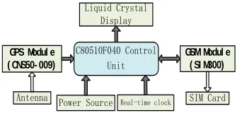
2.1 Truck/Ship-Borne Positioning Terminal
Truck/ship-borne positioning terminal is
composed of the GPS receiver, GSM design, and
SCM C8051F040, which is shown in Fig.2.
GSM Modul e ( SI M300)
Liquid Crystal Display
Real-time clock
C80510F040 Control Unit
GPS Modul e ( CNS50- 009)
SIM Card Power Source
[image:3.612.116.287.440.520.2]Antenna
Figure.2. Truck/Ship-Borne Positioning Terminal
Structure Diagram
Our research has drawn on the GPS,
CNS50-009, which is yielded by a company named
Eastern Star and developed for military application,
with the following reasons: a unexceptionable
operating temperature range of -40 ℃ to +85 ℃,
strong anti-jamming capability, two kinds of data
format: Binary and NMEA [7], and the most
important thing is the CNS50-009 is not be limited
by the top speed, etc. According to above, it is very
suitable for our truck/ship-borne positioning
terminal which operates in harsh environment
generally. Then, the SIMCOM’s SIM300 be used as
our GSM / GPRS module that offers a wide range
of operating temperature and operating frequencies
from EGSM 900MHZ to DCS 1800MHZ and
integrates the complete RF circuit, TCP / IP
protocol and GSM baseband processor, the device
is a low power static and high cost performance
design[8]. In addition, we send correlative short
message in our GSM module through the SIM
card.
In this article, truck/ship-borne positioning
terminal takes satellite positioning as the main
positioning means, supplemented with inertial
navigation, terrain-aided navigation and other
technologies to obtain real-time vehicle location
information, which is then integrated into the
mobile geographic information system technology
that can provide vehicle location, path planning,
information query and other functions whenever
and wherever possible. After receiving positioning
information from GPS, the SCM parses the
received NMEA string information to extract
positioning information, such as latitude, longitude
and elevation and so on, and then sends them to
GSM module, which is the main device of wireless
communication network [9].
2.2 The Tracking And Monitoring Terminal
The main framework of the tracking and
monitoring terminal is constituted by the GPS
server, the SCM design, the GSM module [10], the
design of Google Earth and PC server, as shown in
Fig. 3.
Monitoring center-PC
GSM/GPRS
(SIM300)
System control command
USB/GSM DATA UART0/GSM DATA
GSM Control command
SIM Card GPS Module
(MAX-6Q)
UART
1
Power Supply Module
FT245
The System Clcok
C80510F040
Figure.3.The Tracking And Monitoring Terminal
Structure Diagram
[image:3.612.303.524.595.688.2]ISSN: 1992-8645 www.jatit.org E-ISSN: 1817-3195
forwarding data, which receives GPS positioning
information and other information of the tracking
and monitoring terminal, and then sends it to the
SCM. Meanwhile, the GSM module also receives
GPS positioning information and other relevant
information from truck/ship-borne positioning
terminal to the SCM. After this operation, the
FT245 module implements information
transmission from the tracking and monitoring
terminal to PC, which sends the truck /ship loading
positioning terminal and track and monitor
terminal’s location and alarm information to the
monitor service center, and receives instructions
sent from the monitor service center. That is to say,
the SCM completes GPS signal receiving,
processing and sending. Track display is
implemented by programming with VC and calling
Google Earth in the PC, which mainly includes map
operations, the details of the location where a
moving target stands in real time, zoom in, zoom
out, roam, etc.
3. THE WHOL SOFTWARE FRAME WORK
OF VECHILE POSITIONING
MONITORINF SYSTEM
In the track access system, track data of a
vehicle carrying hazardous chemicals has massive
volumes of data about spatial location, resulting in
a huge amount of data storage and inefficient data
manipulation. In order to improve the storage
efficiency and effective management of vehicle
track data, we need to establish an effective data
management approach to reduce data redundancy
and increase the efficiency of information query. So
it’s a better solution to use C++ as the develop
language and Visual C++ as the develop
environment of the system thanks to its high
efficiency and perfect function, which supports the
COM technology as well as API invoking. The
program of the whole system is divided into two
sub-systems: data management and vehicle track
display.
Vehicle track display and analysis is vital to
monitoring the motion of a object carrying
hazardous chemicals, in our research, we turned to
Microsoft Visual Studio2005(VS 2005)of Microsoft,
it has been widely used thanks to (1) supporting
Data organization described by XLM and (2)
providing XLM designer which facilitate creating
XML document, importantly, (3) KML file
applying the exchange for geographic data in
Google Earth map browser is also XML formats
[11]. So it is an effective solution for us to convert
GPS information to KML FILE that Google Earth
could identify.
3.1 Data Organization
With a view to software designer, data
organization in the vehicle positioning monitoring
system is always a difficult and hot issue, and it is
also a core problem concerning sound and stable
system functions. Relevant vehicle positioning
monitoring data mainly includes the following three
categories [12]:first, base map data, including
administrative divisions, residential areas, gas
stations, arterial streets, etc; second, road network
data, including road centerline network diagrams,
scissors crossing and other road network data; at
last, vehicle monitoring and navigation attribute
data, including vehicle location, driving route,
distance, direction, speed, length of stay in one
position, history data in vehicle operation, etc;
However, relational database system can better
solve parse and storage of vehicle positioning
monitoring data and real-time data transmission,
UART0_Interrupt
UART1_Interrupt
Interrupt Entrance Beginning
Interrupt off
Received GSM data
GSM initialized
Into buffer area
PC Y
Y
FT245 N N
Y If UART0_Interrupt0
free time?
Interrupt off
RI1=1?
tmp1=SBUF1
P=tmp1
Distinguishing frame header $GPGGA
Into array Frame counter reset
Extract Valid data Y N
Y N
Landmarks, location information load
Track display Open interrupt RI0=1?
Interrupt Entrance
Interrupt off
tmp0=SBUF0
GPRS connected Open interrupt
Frame counter reset
Send data through SMS
Frames analysis
Into array
Allow short message sending and GSM Ready Send data through
GPRS
Y
Y N
Y
N Y
N
C=tmp0
Distinguishing frame header $GPGGA
Beginning
N LOOP
Y N
Figure.4. Core Program Flow Chart
Truck/ship-borne positioning terminal receives NMEA0183 protocol string positioning information
that exist in many format[such as $GPGGA,
$GPRMC, $GPGSA, $GPVTG and so on ] from
the GPS receiver[13], while, the information we
need such as latitude, longitude, elevation, time be
stored in something that begin with ‘$GPGGA’ ,the
detail: $ GPGGA, UTC time, latitude, North /
South latitude, longitude, East / West longitude,
quality factor, the number of satellites, the level
precision, high degree of antenna, age of
differential GPS data, the number of differential
base station, etc. The extract algorithm of latitude
as follows:
AfxExtractSubString(latitude,(LPCTSTR)GPG
GA,3,',');
strdu=latitude.Mid(0,2);
strfen1=latitude.Mid(2,2);
strfen2=latitude.Mid(5,5);
longfen=1000000*atol(sfen1)/60.0+1000000*at
ol(strfen260.0;
ltoa(longfen,strfen,10);
strfen.Format("%s",str);
int z=strlen(strfen);
while(z<6)
{
strfen="0"+strfen;
z++;
}
z=strlen(strdu);
while(z<3)
{
sdu="0"+sdu;
z++;
}
latitude=strdu+"."+strfen;
Note: the similar algorithm could be adopted
when extract longitude, elevation, time.
In this article, we turned to the text-based data
via the short message service enabled by the
standard cellular phone communications networks:
GSM (Global System for Mobile
Communication)/GPRS(General Packed Radio
Service) networks, which provides a low-cost,
effective solution in area with an extensive
coverage of mobile phone networks and has
overcome the drawbacks of voice radio-based
solutions[14]. After completing initialization,we
must send AT instruction to check the GSM
networks and then set short messaging mode when
receive corresponding answers through AT +
CMGF: if the result is zero means PDU mode and
others TEXT,and set the phone number by sending
ISSN: 1992-8645 www.jatit.org E-ISSN: 1817-3195
when receive a response ‘>’ and end the operation
with the hexadecimal string 0x1A. The relevant
algorithm of data transmission as follows:
send_at(); delayns(1); send_cmgf(); delayns(1); send_cmgs(); delayns(1); for(ii=0;ii<tempreadcount;ii++) {
while ((IFG1 & UTXIFG0) ==0);
TXBUF0 =newsdata[ii];
}
delayns(2);
while ((IFG1 & UTXIFG0) == 0);
TXBUF0 =0x0D;
delayns(2);
while ((IFG1 & UTXIFG0) == 0);
TXBUF0 =0x1A;
In our experiment we send short messages in
the form of TEXT over GSM, each tracking
message recorded the time, the position (latitudinal
and longitudinal coordinates), the heading direction,
and the activity status of the truck. Given the GSM
network server available, the data updating
frequency in our experiment was about one
message every 30 s to 1 min, which was considered
adequate for the current concrete truck tracking
application. One short message contains up to 160
letters, which is sufficient to relay the current
location and delivery status information of a mixer
truck.
3.2 Track access
We obtains the raw GPS data in WGS-84
coordinate system from truck/ship-borne
positioning terminal, while our geographic data
selects BJ-54 coordinate system, and these two
coordinates not only the origin of the coordinate
system is inconsistent, but also the corresponding
axes are not parallel to the system application, so
it is integrant to execute coordinate
transformation. This study introduce the method
of transformation of seven-parameter as
follows[14]:
1) geodetic coordinate system transform to
rectangular coordinate system of
WGS-8coordinate system:
Assuming geodetic coordinate is ( B, L, H),
and rectangular coordinate is (X,Y,Z),we have
(
)
(
)
(
)
[
N
e
H
]
B
Z
L
B
H
N
Y
L
B
H
N
X
sin
1
sin
cos
sin
cos
2+
−
=
+
=
+
=
Where L, B, H is longitudinal, latitudinal and
height respectively,
and
N
=
a
(
1
−
e
2sin
2B
)
1/2 ,(
2 2)
22
a
b
a
e
=
−
2) Obtain transformation parameters with the method of seven-parameter:
( )
−
−
+
+
+
∆
∆
∆
=
Gi Gi Gi X Y X Z Y Z Gi Gi Gi Di Di DiZ
Y
X
Z
Y
X
k
Z
Y
X
Z
Y
X
0
0
0
1
ε
ε
ε
ε
ε
ε
Where
[
(
∆
X
,
∆
Y
,
∆
Z
)
]
is the translation transformation parameter, andε
X,
ε
Y,
ε
Zare the rotationtransformation parameter.
3) Rectangular coordinate system of WGS-84 coordinate system transform to geodetic coordinate system
(
)
(
)
[
(
) ( )
(
)
]
{
}
( )
22 2
/ 1 2 2
1
sin
1
arctan
arctan
e
N
B
Z
H
H
e
N
Y
X
H
N
Z
B
X
Y
L
−
−
=
+
−
+
+
=
=
Track access is pivotal to monitoring the motion
of hazardous goods and thereby allowing
intervention teams to react immediately with
maximum safety delivery status of a concrete truck,
which is completed through Google Earth with
map file[such as North University map]. While,
two kinds of expansion interfaces be provides in
Google Earth[15]: API (COM) and KML (keyhole
markup language) file that we select in our
research, which is a file based on XML syntax that
describe and save geographic information (such as
points, lines, images, polygons, and model,
etc.).Thereby KML file be used in exchanging for
geographic data in Google Earth map browser,and
defining some ways that geographic data can be
showed. Its applications: ① designate locatio
icons and annotation; ②create a differen
perspective position for each geographical features; ③ stacked images on Earth; ④specify the style of
geographical features; ⑤compile HTML that
describe geographical features , hyperlinks and
embedded images included; ⑥dynamically access
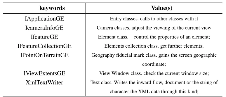
and modify for KML files;⑦3D display. Table 1
[image:7.612.113.500.370.536.2]shows some class used in our research [16]:
Table 1
keywords Value(s)
IApplicationGE IcameraInfoGE
IfeatureGE IFeatureCollectionGE
IPointOnTerrainGE IViewExtentsGE
XmlTextWriter
Entry classes. calls to other classes with it Camera classes. adjust the viewing of the current view
Element class. control the properties of an element; Elements collection class. get further elements; Geography fiducial mark class. gains the screen geographic
coordinate;
View Window class. check the current window size; Text class. Writes the inward flow, document or the string of
character the XML data through this kind;
4. EXPERIMENTAL RESULTS ANALYSIS
In a delivery trip to north university, we
placed the truck/ship-borne positioning terminal
at a car, and send short message with a phone
whose number is 15513044892 by GSM module
to the positioning monitoring terminal, and then
we obtain the positioning information shown in
Fig. 7, in which the green triangle represent the
location of the car carrying the positioning
monitoring terminal, we gain some accurate
spatial location: longitude(112°26'48.4812''),
latitude (38°0'57.3078''),elevation(846.2km).
While the display of the car shown as Fig. 8,
in which blue five-pointed star present the car,
that is to say, truck/ship-borne positioning
terminal, and the red five-pointed star signify the
positioning monitoring terminal,certainly,the
blue line is the track of car. Besides, some blue
text[such as longitude (112°26.71110'),latitude
(38°00.87460'),elevation(823.89km)]appears
on the right of the figure, which is the accurate
ISSN: 1992-8645 www.jatit.org E-ISSN: 1817-3195
text[such as longitude (112°26.71560'), latitude
(38°00.87322'), elevation(826.9km)] means the
spatial location of the positioning monitoring
terminal.
Serial port Baud rate Reset Signal intension
position set
Open GE Display
GPRS status GPRS off
On-line IP
GPRS send
Remote on-line Initialize Disconnect Number Remote GPS position
Figure.7 The Positioning Display Software Interface
Schematic Diagram
North University of China(NUC)
Hospital of
NUC Laboratory block
Of NUC Attached middle school
of NUC
Library of NUC
Material Science and Engineering institute The Department
of music Of NUC
The Department of music Of NUC
Science institute of NUC
Current Map: Shanxi Province(800km*800km) Data playback... Current Map: blank-self-adaption Data playback... Data playback end Current Map: Shanxi-NUC Data playback end Data playback...
Data playback...
Data playback end Data playback... Data playback end
Current Map: Shanxi Province-NUC 2012-12-19 16:14
The show-how system of track display
GPS Information-Truck/ship-borne positioning terminal
GPS Information-The tracking and monitoring terminal
Vertical distance
Figure.8 Track Software Interface Schematic
5. CONCLUSION
With the development of the transportation of hazardous materials,in this paper, we elaborate a high-precision, fast and accurate GPS vehicle positioning monitoring system based on multiple networks. Practice shows that the application of GSM network, mobile GIS and GPS in vehicle positioning monitoring system has improved the accuracy of spatial location of moving vehicles, and has helped visual display of located objects, which has also verified the feasibility to integrate GSM network and Google Earth for mobile location services. It has important theoretical and
practical value to further study the algorithm and avoid or reduce occurrence of accidents caused by hazardous chemicals and improve the security and reliability of hazardous chemicals transportation further study the algorithm.
REFERENCES
[1] E. Planas, E. Pastor, F. Presutto, J. Tixier. Results of the MITRA project: Monitoring and intervention for the transportation of dangerous goods. Journal of Hazardous Materials,152 (2008) 516–526.
[2] Joanne Ellis. Analysis of accidents and incidents occurring during transport of packaged dangerous goods by sea. Safety Science, 49 (2011) 1231–1237
[3] Roberto Bubbico, Sergio Di Cave, Barbara Mazzarotta, Barbara Silvetti. Preliminary study on the transport of hazardous materials through tunnels. Accident Analysis and Prevention, 41 (2009) 1199–1205
[4] Christophe Adrados, Irène Girard, Jean-Paul Gendner, Georges Janeau. Global Positioning System (GPS) location accuracy improvement due to Selective Availability removal, C. R. Biologies 325 (2002) 165–170.
[5] G. Mintsis, S. Basbas, P. Papaioannou, C. Taxiltaris, I.N. Tziavos. Applications of GPS technology in the land transportation system. European Journal of Operational Research, 152 (2004) 399–409.
[7] Adam Theiss, David C. Yen, Cheng-Yuan Ku. Global Positioning Systems: an analysis of applications, current development and future implementations. Computer Standards & Interfaces,27 (2005) 89–100.
[8] He Rongyu , Zhao Guolei, Chang Chaowen, Xie Hui, Qin Xi, Qin Zheng. A PK-SIM card based end-to-end security framework for SMS. Computer Standards & Interfaces, 31 (2009) 629–641
[9] Zechun Huang, Dingfa Huang,Zhu Xu ,Zhigen Xu. GPS Vehicle Positioning Monitoring System Integrated with CORS and Mobile GIS. Procedia Environmental Sciences, 10 ( 2011 ) 2498 – 2504.
[10] Xiaoying Yang, Geng-Ming Jiang, Xingzhang Luo, Zheng Zheng. Preliminary mapping of high-resolution rural population distribution based on imagery from Google Earth: A case study in the Lake Tai basin, eastern China. Applied Geography, 32 (2012) 221e227.
[11] R Galas and W. Kiihler. A Binary Exchange Format for GPS Data. Phys. Chem. Earth,2001.
[12] AijunChen, GregoryLeptoukh, StevenKempler, ChristopherLynnes,
Andery Savtchenko, DenisNadeau,JohnFarley. Visualization of
A-Train vertical profiles using GoogleEarth. Computers & Geosciences ,35 (2009) 419–427.
[13] Simson Garfinkel. Digital forensics XML and the DFXML toolset. Digital Investigation, 8 (2012) 161–174
[14] Declan G.DePaor, StevenJ.Whitmeyer. Geological and geophysical modeling on virtual globes using KML, COLLADA, and Javascript. Computers & Geosciences, 37 (2011) 100–110.
[15] Lisa M.Ballagh, BruceH.Raup, RuthE.Duerr,
SiriJodhaS.Khalsa, ChristopherHelm, Doug Fowler, AmrutaGupte. Representing scientific data sets in KML: Methods and challenges. Computers & Geosciences, 37 (2011) 57–64.
[16] E. J. KANSA. Local, Point-Wise Rotational Transformations of the Conservation Equations into Stream-Wise Coordinates. Computers and Mathematics with Applications ,43 (2002) 501-511.