
© 2017, IRJET | Impact Factor value: 5.181 | ISO 9001:2008 Certified Journal | Page 718
SENSPEED: Sensing Driving Conditions to Estimate Vehicle Speed in
Urban Environments
Prabhavathi. K
1, Shreeja. S
2, Prakruthi. N. P
3, Veerabhadresha. B. S
4, Ranganatha
51
Assistant Professor, Dept. Of ECE, BGSIT, Karnataka, India
2,3,4,5
UG student, Dept. Of ECE, BGSIT, Karnataka, India
---***---Abstract -
Acquiring immediate vehicle speed is desirable and a keystone to several important vehicular applications. This paper uses Smartphone sensors to approximate the vehicle speed, especially when GPS is not available or imprecise in urban environments. In specific, we estimate the vehicle speed by integrating the accelerometer’s readings over time and determine the acceleration errors can lead to huge deviations between the required speed and the real practical one. Further analysis shows that the changes of acceleration errors are very minute overtime which can be rectified at some points, called reference points, where the true vehicle speed can be obtained. Recognizing this observation, we propose an accurate vehicle speed estimation system, SenSpeed, which senses natural driving conditions in urban environments including taking turns, stopping and passing through uneven road surfaces, to derive reference points and further to removes the speed estimation deviations caused by acceleration errors. Extensive experiments demonstrate that SenSpeed is accurate and vigorous in real driving environments.Key Words: Sensing, Driving Conditions, Vehicle Speed,
Urban Environments, predefined reference.
1. INTRODUCTION
The Smartphone based vehicular applications analyze the increasingly complex urban traffic flows and facilitate more intelligent driving experiences including vehicle localization, enhancing driving safety, driving behavior analysis and building intelligent transportation systems. The vehicle speed is an essential input among these applications. The speed of a vehicle can be estimated from GPS which is embedded in Smartphone often suffers from the urban canyon environment, which could result in low availability, low accuracy, the low update rate of GPS is not able to keep up with the frequent change of the vehicle speed, drains the phone battery and also hard to obtain accurate vehicle speed. There are a couple of alternatives by using either the OBD-II interface or Smartphone’s cell tower signals. However, the existing studies utilizing Derivative Dynamic Time Warping (DDTW) algorithm introduces large overhead on collecting offline trace and prevents large scale deployment. In this paper we consider a sensing approach, which uses Smartphone sensors to sense natural driving conditions, to derive the vehicle speed without requiring any additional hardware. The basic idea is to obtain the vehicle’s speed estimation by integrating the phone’s accelerometer
readings along the vehicle’s moving direction over time. Challenges arises i.e. First, the accelerometer readings are noisy and affected by various driving environments. Second, the speed estimation should be real-time and accurate. Finally, the solution should be lightweight and computational feasible on Smartphone. SenSpeed measures the acceleration error between each two adjacent reference points and eliminates such errors to achieve high-accuracy speed estimation.
2. RELATED WORK
In this section, we review the existing work on vehicle speed estimation, which can be categorized as follows.
2.1 Estimation using Pre-deployed infrastructures:
We have two vehicle speed estimation mechanisms where one through the loop detectors, but its installation cost is high, and the other is using traffic cameras, but it is low accuracy on bad weather conditions.2.2 Estimation using additional devices:
In real-time, to provide the vehicle speed OBD-II adapter is a popular interface. In open environments, Acoustic wave sensors are utilized to estimate the vehicle speed and traffic magnetic sensors are also used to capture the vehicle speed. But it wants additional hardware components to perform speed estimation.2.3 Estimation using phones:
Modern studies use cell phones to measure the vehicle speed. In particular, use GPS or sub- sampled GPS to drive the vehicle speed. Although GPS is a simple way to find vehicle speed, there are lots of draw backs1. The urban canyon environment and the low update frequency of GPS make it difficult to accurately capture the frequent changing vehicle speed in urban environments.
© 2017, IRJET | Impact Factor value: 5.181 | ISO 9001:2008 Certified Journal | Page 719 becomes more and more important in supporting
large amounts of vehicular applications.
3. DESIGN OF SENSPEED
In this section, we present the design of our proposed system, SenSpeed, which estimates vehicle speed accurately through sensing driving conditions in urban environments. SenSpeed does not depend on any pre-deployed infrastructure and additional hardware.
3.1 System Overview
By integrating of acceleration data over time, speed of the vehicle can be estimated. However, huge deviations between the true speed and the estimated speed are caused by the accumulative error. In order to know accurate vehicle speed estimation, SenSpeed senses the natural driving conditions which will identify the reference points. Then it makes use of information of the reference points to evaluate the acceleration error and additionally eliminates accumulative error.
SYSTEM ARCHITECTURE
Our system identifies three kinds of reference points, i.e. making turns, Stopping, Passing through uneven road surfaces. These can achieve by sensing natural driving conditions based on smart phone sensors. The work flow of SenSpeed is shown in Figure. SenSpeed uses two kinds of sensors in smart phones, accelerometers and gyroscopes, to estimate the vehicle speed. The accelerometer is used to monitor the vehicle acceleration and the gyroscope is used to monitor the vehicle angular speed.
In order to get the readings from the accelerometer and the gyro- scope, SenSpeed first performs Coordinate Reorientation to align the phone’s coordinate system with the vehicles.
After that, the raw speeds are obtained by computing the integral of the aligned readings from the accelerometer in Raw Speed Estimation. In the meantime, SenSpeed senses reference points by analyzing the aligned readings from the accelerometer and the gyroscope in Sensing
Reference Points and infers the vehicle speed at each reference point.
Next, in Acceleration Error Measurement, determine the acceleration errors between each two adjacent reference points and then use it to correct the raw speed estimations in Reference Points Correction.
Finally, SenSpeed outputs high-accuracy speed estimations. In order to achieve accurate speed estimations, the speeds at the two adjacent reference points need to be known.
However, the speed at the next reference point is unknown on the real-time speed estimation, so it is not possible to calculate the acceleration error between two reference points. Since we know the changes of the acceleration error over time are very small, Acceleration Error Measurement uses the exponential moving average to obtain the current acceleration error from latest histories.
3.2 System Design
In this project we designed two modes of operation. Firstly, normal mode of operation where speed controlling done manually. Secondly, automation mode where speed controlling done automatically.
3.2.1 Normal Mode:
At presently, speed was controlled by manually in the entire vehicle. If the vehicle travel with the speed above the reference point it doesn’t control the vehicle. It estimates the speed and display exceeding speed on the led display. Vehicle can travel in uneven surface and go with over speed. Even though there is a detection of two conditions GSM and GPS is in off mode that is the SMS will not send to the previously duped number.
3.2.2 Automation Mode:
In today’s traffic in the urban environment, secured mode of driving is necessary .so we can implement secured driving condition automatically using two sensor one vibration sensor and another is MEMS sensor.
Vibration sensor:
Accelerometers operate on the piezoelectric principal: a crystal generates a low voltage or charge when stressed as for example during compression.
© 2017, IRJET | Impact Factor value: 5.181 | ISO 9001:2008 Certified Journal | Page 720 is more rugged than a coil and magnet sensor, has a wider
frequency range, and can perform accurate phase measurements. Most industrial piezoelectric sensors used in vibration monitoring today contain internal amplifiers. In this project vibration sensor is used to find the over speed depending on the reference speed and display on the LCD display.
MEMS sensor:
It is also called as accelerometer sensor. The operation of MEMS senor is first performs Coordinate Reorientation to align the phone’s coordinate system with the vehicles.
After that, the raw speeds are obtained by calculating the integral of the aligned readings from the accelerometer in Raw Speed Estimation. Meanwhile, SenSpeed senses reference points by analyzing the aligned readings from the accelerometer and the gyroscope in Sensing Reference Points and infers the vehicle speed at each reference point. Next, in Acceleration Error Measurement, the acceleration errors between each two adjacent reference points are calculated and then used to correct the raw speed estimations in Reference Points Correction. Finally, SenSpeed outputs high-accuracy speed estimations. It is used to measure the direction of the vehicle. If the axis of vehicle changes then it infer the microcontroller that it was under rash driving condition or it met with the accident. In this project MEMS sensor is used to find uneven surface in which vehicle is travelling.
Messaging:
If the vehicle is travelling above the reference point or axis of the vehicle changes then GPS tracking system the location of vehicle is sent to remote place and it is done by GSM modem. Global Positioning System (GPS) modem requires minimum 3 satellites to calculate the exact location. This modem communicates only in single way with 8051 microcontroller. This means that it can only transmit data to microcontroller. GPS Modem does not receive any data from microcontroller. At the same time GPS modem does not send data to Satellite, it only receives signal from satellites. Microcontroller gets the coordinates from GPS modem and then it sends this information to the user in Text SMS.
4. RESULT
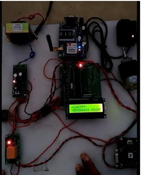
[image:3.595.319.549.89.364.2]The system prototype arrangements of the proposed technology in order to implement of various design features like estimation of current speed, comparing with the reference speed and detecting any over speed followed by intimating the pre-defined number using GSM and GPRS technologies is as depicted in the following image.
FIGURE 4.1 PROTOTYPE DEPICTING THE PROJECT SETUP
[image:3.595.318.551.405.693.2]© 2017, IRJET | Impact Factor value: 5.181 | ISO 9001:2008 Certified Journal | Page 721 FIGURE 4.3 DISPLAYING THE SPEED OF THE VEHICLE
Also by utilising the MEMS technology, which measures change in the axis of the vehicle to determine the uneven surface along the road while travelling.
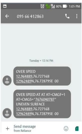
[image:4.595.313.555.87.362.2]FIGURE 4.4 DISPLAYING UNEVEN SURFACE
FIGURE 4.5 DISPLAYING WHEN THE VEHICLE IN UNEVEN SURFACE
By using GPS the system measures the lattitude and the longitude values to determine the exact location of the vehicle along withe other observations are sent using GSM.
[image:4.595.39.284.429.718.2] [image:4.595.351.516.450.720.2]© 2017, IRJET | Impact Factor value: 5.181 | ISO 9001:2008 Certified Journal | Page 722
5. CONCLUSIONS
In this paper, we address the problem of performing exact vehicle speed estimation in urban environments to support pervasive vehicular applications. To accomplish high estimation accuracy, we utilize Smartphone sensors to sense natural driving conditions. In specific, we put forward a vehicle speed estimation system called SenSpeed to identify three useful reference points, including making turns, vehicle stopping, and passing through uneven road surfaces, to measure and eliminate the errors caused by directly using phone’s accelerometer readings for speed estimation. The key insight is that natural driving conditions present unique features and can be exploited to en- able accurate real-time vehicle speed estimation. Our extensive experiments driving in two different cities over one month time period show that SenSpeed can estimate the vehicle speed in real-time with a low average error of 1.32mph, while achieving 0.75mph during the offline estimation.
REFERENCES
[1] J. Levinson and S. Thrun, “Robust vehicle localization in urban environments using probabilistic maps,” in Proc. IEEE Int. Conf. on Robotics and Automation, 2010, pp. 4372–4378.
[2] Y. Wang, J. Yang, H. Liu, Y. Chen, M. Gruteser, and R. P.Martin, “Sensing vehicle dynamics for determining driver phone use,” in Proc. of ACM MobiSys’13, 2013, pp. 41–54.
[3] G. Chandrasekaran, T. Vu, A. Varshavsky, M. Gruteser, R. Martin, J. Yang, and Y. Chen, “Tracking vehicular speed variations by warping mobile phone signal strengths,” in Proc. IEEE PerCom’2011, 2011, pp. 213–221.
[4] G. Chandrasekaran, T. Vu, A. Varshavsky, M. Gruteser, R. P. Martin, J. Yang, and Y. Chen, “Vehicular speed estimation using received signal strength from mobile phones,” in Proc. ACM Ubicomp’10, 2010, pp. 237–240.
![catena Poly[[di μ iodido dicopper(I)(Cu—Cu)]bis(μ 4,4′ di 3 pyridyl 2,2′ disulfanediyldipyrimidine)]](data:image/gif;base64,R0lGODlhAQABAIAAAP///wAAACH5BAEAAAAALAAAAAABAAEAAAICRAEAOw==)