Scholarship@Western
Scholarship@Western
Electronic Thesis and Dissertation Repository
6-20-2014 12:00 AM
New Opportunities in Digital Archaeology: The Use of Low-Cost
New Opportunities in Digital Archaeology: The Use of Low-Cost
Photogrammetry for 3D Documentation of Archaeological Objects
Photogrammetry for 3D Documentation of Archaeological Objects
from Banks Island, NWT
from Banks Island, NWT
Colleen Haukaas
The University of Western Ontario
Supervisor Dr. Lisa Hodgetts
The University of Western Ontario Graduate Program in Anthropology
A thesis submitted in partial fulfillment of the requirements for the degree in Master of Arts © Colleen Haukaas 2014
Follow this and additional works at: https://ir.lib.uwo.ca/etd Part of the Archaeological Anthropology Commons
Recommended Citation Recommended Citation
Haukaas, Colleen, "New Opportunities in Digital Archaeology: The Use of Low-Cost Photogrammetry for 3D Documentation of Archaeological Objects from Banks Island, NWT" (2014). Electronic Thesis and Dissertation Repository. 2117.
https://ir.lib.uwo.ca/etd/2117
This Dissertation/Thesis is brought to you for free and open access by Scholarship@Western. It has been accepted for inclusion in Electronic Thesis and Dissertation Repository by an authorized administrator of
OBJECTS FROM BANKS ISLAND, NWT
(Thesis format: Integrated Article)
by
Colleen Jaclyn Haukaas
Graduate Program in Anthropology
A thesis submitted in partial fulfillment of the requirements for the degree of
Master of Arts
The School of Graduate and Postdoctoral Studies The University of Western Ontario
London, Ontario, Canada
ii
Abstract
This thesis investigates the use of low-cost three-dimensional (3D) modelling programs (Agisoft Photoscan and 123D Catch) to create and disseminate digital replicas of archaeological features and artifacts in the context of the Ikaahuk Archaeology Project, a community-based archaeology project on Banks Island, Northwest Territories. It aims to 1) assess the benefits and challenges of low-cost photogrammetry for in-situ documentation of hunter-gatherer archaeological features; 2) determine the usefulness of low-cost
photogrammetry for replicating small-scale artifacts in comparison to 3D scanning methods; and 3) explore how Internet media can be used to disseminate 3D models. This thesis
demonstrates that low-cost methods of 3D modelling are sufficiently able to replicate many types of archaeological objects, and are accessible due to their low cost, ease of use, and compatibility with online dissemination. As a result low-cost 3D modelling has a promising future in archaeological documentation, conservation, and engagement with non-specialist audiences.
Keywords
iii
Acknowledgments
I would like to acknowledge the Social Sciences and Humanities Research Council of
Canada and the Northern Scientific Training Program for providing financial contributions to this research. Logistical support was provided by the Polar Continental Shelf Program. Additional logistical support was provided by the Aurora Research Institute in Inuvik and Parks Canada’s Western Arctic Field Unit (WAFU).
Artifacts in this study were loaned from the Prince of Wales Northern Heritage Centre. Thank you to Joanne Bird, Pat Freeman, Susan Irving, Ryan Silke, Tom Arnold, and Glen MacKay for arranging the artifact loan and welcoming me to their facility. 3D scanning was carried out at Sustainable Archaeology research facility. I would like to thank all of the staff, including Dr. Neal Ferris, Dr. Rhonda Bathurst, and Kira Westby at the Sustainable
Archaeology for the use of their equipment and for all of their patience and assistance while I was learning how to use it.
A very special thank you goes to the community of Sachs Harbour. Thank you to the Sachs Harbour Community Corporation and the Sachs Harbour Hunters and Trappers Committee for permitting this research and thank you to the many people who welcomed me into their homes during my stay in Sachs Harbour.
Thank you to my supervisor Dr. Lisa Hodgetts for contributions to this thesis and for the never-ending patience and encouragement. Thank you also to Edward Eastaugh for the much-needed technical support, and to the rest of the faculty, staff, and fellow graduate students of the Anthropology department of Western for sharing their wisdom during my coursework and research.
iv
Table of Contents
Abstract ... ii
Acknowledgments... iii
Table of Contents ... iv
List of Tables ... vii
List of Figures ... viii
1 Chapter 1: Introduction ... 1
1.1.1 3D Modelling in Archaeology ... 2
1.1.2 3D Modelling Technologies ... 2
1.1.3 Applications of 3D Modelling in Archaeology ... 4
1.1.4 Public and Community Engagement in Archaeology through 3D Models 6 1.1.5 Banks Island Archaeology ... 11
1.1.6 Geographic Context ... 11
1.1.7 Archaeological Context ... 12
1.1.8 Ikaahuk Archaeology Project ... 14
1.1.9 Thesis Objectives ... 15
1.1.10 Thesis Materials ... 15
1.1.11 Sample 1: In-situ Archaeological Features from Field Investigations... 15
1.1.12 Sample 2: Museum Artifacts from the Prince of Wales Northern Heritage Centre ... 18
1.1.13 Online Dissemination... 20
1.1.14 Thesis Organization ... 21
1.2 References ... 22
2 Applications of Low-Cost Photogrammetry to Replicate and Disseminate Archaeological Features in-situ on Banks Island, NWT ... 32
v
2.1.2 3D Modelling in Archaeology ... 33
2.1.3 Problems in Archaeological Applications of Photogrammetry ... 35
2.1.4 Materials and Methods ... 38
2.1.5 Ikaahuk Archaeology Project ... 38
2.1.6 Archaeological Features Recorded ... 41
2.1.7 Photographic Recording... 44
2.1.8 3D Model Generation ... 44
2.1.9 Online Dissemination... 49
2.1.10 Results ... 51
2.1.11 Photoscan and 123D Catch in in-situ Field Recording ... 52
2.1.12 Photogrammetry for Recording Hunter-Gatherer Archaeological Features ... 56
2.1.13 Disseminating 3D Models... 58
2.1.14 Discussion and Implications for Future Research ... 62
2.1.15 Photogrammetry for in-situ Documentation ... 62
2.1.16 Photogrammetry for Hunter-Gatherer Archaeology ... 63
2.1.17 Disseminating 3D Models with a Community or Public Audience ... 66
2.1.18 Conclusions ... 67
2.1.19 References ... 68
3 Comparison of 3D Scanning and Low-Cost Photogrammetry to Replicate Small-Scale Artifacts from Museum Collections ... 78
3.1.1 Background Information ... 80
3.1.2 3D Modelling in Archaeology ... 80
3.1.3 3D Modelling in Archaeological Engagement ... 83
3.1.4 3D Models and Social Media ... 84
3.1.5 Materials and Methods ... 85
vi
3.1.7 3D Scanning ... 88
3.1.8 Photogrammetry ... 91
3.1.9 Disseminating 3D Models... 92
3.1.10 Assessing 3D Models and Methods ... 93
3.1.11 Results ... 94
3.1.12 3D Scanning ... 94
3.1.13 Photoscan ... 99
3.1.14 123D Catch ... 102
3.1.15 Dissemination of 3D Models ... 103
3.1.16 Discussion ... 105
3.1.17 Advantages and Disadvantages of High- and Low-Cost 3D Replication Methods... 105
3.1.18 Advantages and Disadvantages of Online Dissemination Methods ... 107
3.1.19 Implications for Future Research ... 108
3.1.20 Digital replicas and Community-Based Archaeology ... 110
3.1.21 Conclusion ... 112
3.1.22 References ... 112
4 Conclusion ... 120
4.1.1 Objective One ... 120
4.1.2 Objective Two ... 121
4.1.3 Objective Three ... 122
4.1.4 Considerations for Future Research ... 123
4.1.5 References ... 124
Appendices ... 126
vii
List of Tables
Table 1: Sites investigated by Ikaahuk Archaeology Project and approximate dates of
occupation ... 38
Table 2: Comparison of Average Number of Computed Faces of 3D Models Created with
Photoscan and 123D Catch at Medium and High Quality Target Levels ... 54
Table 3: Comparison of Average Processing Time (Minutes) of Meshes in 3D Models created with Photoscan and 123D Catch at medium and high target quality levels. ... 55
Table 4: Comparing Average Number of Computed Faces According to Archaeological Feature Type in Models Created in Photoscan and 123D Catch at Medium Target Quality . 58
Table 5: Comparison of the average file size of PDFs and videos generated in Photoscan and
123D Catch, respectively. ... 59
Table 6: Artifacts scanned with 3D3 White Light Scanner. Table compares artifact material, artifact size, scans recorded, and the number of computed faces in original and decimated scans. ... 97
Table 7: Recorded time required to capture data and build 3D models with the 3D3 White Light Scanner, Photoscan, and 123D Catch ... 99
Table 8: Artifacts replicated with 3D3 White Light Scanner, Photoscan, and 123D Catch. Table compares artifact material, artifact size, and the number of computed faces for 3D models. ... 100
viii
List of Figures
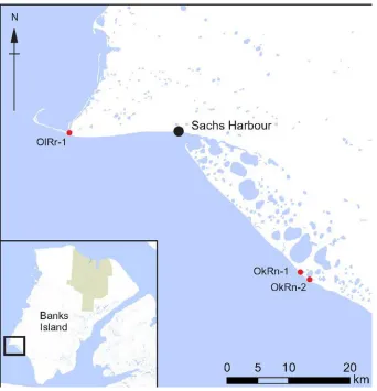
Figure 1: Location of Sachs Harbour and Banks Island. ... 12
Figure 2: Timeline of Occupation on Banks Island since 4000 BP ... 13
Figure 3: Map showing location of sites on Banks Island where features were photographed. ... 17
Figure 4: Map showing location of archaeological sites where artifacts replicated in this study were recovered. ... 20
Figure 5: Map showing the location of Sachs Harbour and Banks Island in Canada ... 39
Figure 6: Map showing the locations of study sites: Cape Kellett (OlRr-1), Agvik (OkRn-1), and Seal Camp (OkRn-2) ... 40
Figure 7: Sod houses from Cape Kellett. Left: House 1. Right: House 3. ... 42
Figure 8: Caches from Seal Camp. Left: Cache 5. Right: Cache 21. ... 42
Figure 9: Tent Rings from Seal Camp. Left: Tent Ring 3. Right: Tent Ring 9. ... 43
Figure 10: Isolated artifacts. Left: Artifact 1 from Seal Camp. Right: Pottery from Agvik. .. 44
Figure 11: Photograph in pre-processing with Photoscan. Mask is applied to hide the water, sky, and insects in the photograph. ... 46
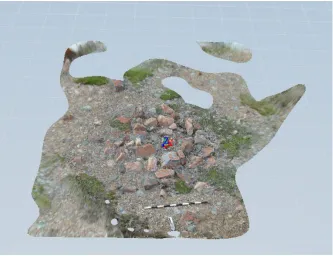
Figure 12: Image showing the 3D model of Cache 5 at the four workflow stages of Photoscan. Top left: sparse point cloud generation after photo alignment. Top right: dense point cloud. Bottom left: 3D surface (mesh). Bottom right: 3D surface with texture. ... 47
Figure 13: Cache 5 after processing in 123D Catch. Areas with stretched mesh and large holes are still visible along the edges of the 3D model, and can be trimmed before the model is exported. ... 49
ix
Figure 15: Average Percent of Photographs Aligned in Photoscan and 123D Catch ... 53
Figure 16: Textured Meshes of Cache 5. Top left: 123D Catch, medium target quality. Top right: 123D Catch, high target quality. Bottom left: Photoscan, medium target quality. Bottom right: Photoscan high target quality. ... 54
Figure 17: Comparison of Average Processing Time (Minutes) and Quality (Computed Faces) of 3D Models created with Photoscan and 123D Catch. Data points are labelled with their respective software program and target quality level. ... 56
Figure 18: Average Percent of Photographs Aligned in Photoscan and 123D Catch According to Archaeological Feature Classification ... 57
Figure 19: Unsuccessful 3D model of sod house (House 3) in Photoscan. ... 58
Figure 20: PDFs generated at different target qualities for 3D models of Cache 5 generated in Photoscan. Left to right: High quality, high quality with decimated mesh, and medium quality. ... 60
Figure 21: Still images from videos generated in 123D Catch of Cache 21. Top: HD 1080p. Middle: HD 720p. Bottom: Mobile. ... 61
Figure 22: 3D Model of a Tent Ring by Tim Rast (2012), created with 123D Catch. ... 64
Figure 23: Map showing the location of Sachs Harbour ... 80
Figure 24: Map showing location of sites included in this study ... 88
Figure 25: Scan of decorated harpoon head (PWNHC 982.50.362). Left: Original Scan. Right: Decimated Scan with Texture. ... 90
Figure 26: Example of BMP image used in texture mapping. Image is the texture map for the decorated harpoon head (PWNHC 982.50.362). ... 90
x
Figure 28: Left: Awl (PWNHC 982.50.154). Right: Lure (982.44.003). The geometry of the lure was more complex than the awl, requiring more scans to fully capture it. ... 96
Figure 29: The average number of computed faces in 3D models generated by the 3D3 White Light Scanner (original and decimated scans), Photoscan, and 123D Catch. ... 101
Figure 30: Awl (PWNHC 982.47.009). Left: 3D3 White Light Scanner. Mesh decimated. Center: Photoscan. Mesh processed at high quality with a dense point cloud. Right: 123D Catch. Mesh generated at Maximum Quality. ... 102
Figure 31: Kamik (boot; PWNHC 982.50.173). Left: Photoscan. Right: 123D Catch. ... 109
Chapter 1
1
Chapter 1: Introduction
This thesis investigates the use of low-cost three-dimensional (3D) modelling programs to create and disseminate digital replicas of archaeological features and artifacts in the context of the Ikaahuk Archaeology Project, a community archaeology project on Banks Island, Northwest Territories (NWT). Research over the last two decades has indicated that 3D modelling, or documenting and visualizing archaeological objects digitally in 3D, is valuable in archaeological research, conservation, and presentation to broad audiences as it can create realistic and accurate digital copies of archaeological objects. In the past, 3D modelling technologies were prohibitively expensive and too technologically
1.1.1
3D Modelling in Archaeology
1.1.2
3D Modelling Technologies
Digital 3D models are one way that archaeologists digitize, replicate, and represent archaeological objects, including landscapes, sites, features, and artifacts. A 3D model is a mathematical representation of an object, consisting of a triangulated network (“mesh”) or textured digital surface that can be viewed in 3D using specific software or in two-dimensions through a 3D rendering process (Remondino and El-Hakim, 2006). Archaeology and heritage applications generally favour reality-based 3D modelling techniques, which extract data from the surfaces of real-world objects in order to build meshes, since this method creates 3D models that most closely match the original objects (Remondino and Rizzi, 2010). Improvements in 3D technologies in the last 25 years allow archaeologists to make digital replicas of archaeological objects that are accurate, high-resolution, and quick to produce (De Reu et al., 2014; Dellepiane et al., 2011; Kersten and Lindstaedt, 2012; Scopigno et al., 2011).
Currently there are two main types of 3D modelling techniques that archaeologists use to create digital replicas of sites, features, and artifacts: 3D scanning and photogrammetry. 3D scanning refers to the use of highly specialized equipment that measures and
reconstructs the surface of an object using technology based on stereovision, light wave, or sound wave distance measurement (Lerma et al., 2010; Remondino and El-Hakim, 2006; Remondino et al., 2008). 3D scanners collect information in the form of a 'point cloud', or a series of points, which are then used to create a digital “mesh” surface that matches the surface of the original object (Boehler and Marbs, 2004). Alternatively, photogrammetry methods extract information from 2D photographs to reconstruct objects in 3D (Doneus et al., 2011; Lambers et al., 2007; Verhoeven et al., 2012). This technique, also known as image-based 3D modelling, uses structure-from-motion and
stereo-reconstruction algorithms to identify and match shared points from overlapping photographs to create point clouds and meshes representing the surface of an object.
knowledge and training to use it (Boehler and Marbs, 2004; Scopigno et al., 2011). Only archaeologists with backgrounds in computer science could personally utilize 3D
technology, and very often outside companies were hired, at great expense, to design the software and hardware for a project and then perform the 3D modelling (Fryer, 2007). Currently, archaeologists no longer need to have hardware or software custom-built for their projects, as both are more commonly produced and less expensive than their predecessors (Kersten and Lindstaedt, 2012; Remondino and El-Hakim, 2006; Wurtz, 2011). Nevertheless, 3D scanners and professional photogrammetry software remain relatively expensive and still tend to require specialized training and knowledge to use.
Since the mid-2000s, advances in photogrammetry have opened up the technology to a broader user base. A variety of low-cost, free, and open source programs and web services now allow users to create 3D models using digital photographs taken using off-the-shelf digital cameras with no additional specialized equipment. Several of these programs are also partially or fully automated, carrying out the steps of identifying and matching points in photographs, building point clouds and meshes, and applying texture to 3D models with little to no manual input from users. A few archaeologists have already recognized the potential of inexpensive, user-friendly photogrammetry software, and have begun exploring the efficacy of several programs. While as recently as ten years ago photogrammetry did not create content that was as high in detail or quality as that of 3D scanners (Boehler and Marbs, 2004), recently-developed low-cost programs such as
Blender (Kersten and Lindstaedt, 2012), Autodesk 123D Catch (previously known as
Autodesk Firefly during beta; Brutto and Meli, 2012; Kersten and Lindstaedt, 2012; Nguyen et al., 2012; Santagati et al., 2013), and Agisoft Photoscan (De Reu et al., 2014, 2013, 2013; Doneus et al., 2011; Verhoeven et al., 2012) are steadily improving, and can provide results that are comparable in detail and accuracy to 3D scanning (Doneus et al., 2011; Kersten and Lindstaedt, 2012).
important to continue testing the use of these technologies on new types of archaeological objects (Nguyen et al., 2012). For example, low-cost photogrammetry has been
successfully applied to document historic sites with substantial architectural features such as monuments or temples, stone foundations of buildings, and large, complex excavation pits (De Reu et al., 2014, 2013; Plets et al., 2012; Santagati et al., 2013), but the
technology remains unexplored in the context of hunter-gatherer archaeology, where archaeological features are comparatively smaller and less geometrically complex. Similarly, low-cost photogrammetry can document large, complex areas, but few examples use low-cost photogrammetry to make 3D models of small-scale artifacts (Kersten and Lindstaedt, 2012; Nguyen et al., 2012).
1.1.3
Applications of 3D Modelling in Archaeology
Further exploration of different 3D modelling technologies is necessary because of the broad range of contexts where 3D modelling can benefit archaeological research. In archaeological investigations, 3D modelling has been used as a way to document
archaeological investigations (Benko et al., 2004; Doneus et al., 2011; Plets et al., 2012), rock art (Chandler et al., 2007; Lerma et al., 2010; Simpson et al., 2004), artifacts and statues, (Dellepiane et al., 2011; Karasik and Smilansky, 2008; Kersten and Lindstaedt, 2012; Scopigno et al., 2011; Stanco et al., 2011), and landscapes (Eisenbeiss et al., 2005; Lambers et al., 2007; Landry et al., 2014). 3D modelling has advantages over traditional 2D means of recording, such as photographs and manual drawings, as it can fully capture the 3D shape and detailed texture of archaeological features (De Reu et al., 2014; Plets et al., 2012). As a recording technique, 3D modelling is also quicker and more accurate than manual drawing (Doneus et al., 2011). In documenting the excavations of a building foundation, De Reu et al. (2014) found that 3D recording allowed them to capture all of the metric information about the site that would have been recorded with traditional documentation methods, but at a quicker pace and with added information about the texture and shape of the objects that would otherwise have been lost during excavation.
threatening in areas with extreme climates, such as the circumpolar regions (Barr, 2004; Dawson et al., 2013; Remondino and Rizzi, 2010). 3D technologies have been used in recent years to make copies of threatened archaeological sites or objects before they are further damaged so that future stakeholders will have access to these objects in a digital, if not physical, form. For example, Dawson et al. (2013) used laser scanners to document historic Fort Conger on Ellesmere Island in northern Nunavut, which is a historically important site in danger of destruction from rising sea levels, storms, and coastal erosion related to climate change. While the original Fort Conger remains at risk of destruction, there is now a high-resolution and accurate digital replica that will remain available for study in perpetuity.
In addition, objects that are already partially destroyed can be digitally reconstructed or restored through manipulation of digital replicas in 3D modelling programs (Koller et al., 2010; Stumpfel et al., 2003). This allows archaeologists to create fully-restored replicas without altering or damaging the original objects. With individual artifacts,
archaeologists can digitally reassemble broken pieces of artifacts, or create replicas of incomplete artifacts with missing areas restored artificially. Compared to physical restoration, digital restoration has the advantage of being able to quickly create multiple replicas to propose and test multiple hypotheses about the original shape, colour, or materials of missing parts of objects without altering the original form (Dellepiane et al., 2011). For example, Arbace et al. (2013) were able to digitally reconstruct the Madonna of Pietranico, a terracotta statue that was severely damaged in a 2009 earthquake, by 3D scanning the individual pieces of the statue and reassembling them using 3D modelling software. Besides restoring the shape of the object, the team was also able to digitally restore the paint on the surface of the statue that had been damaged both during the earthquake and naturally over time.
digital replicas of 10 well-known statues, including the David, and made them available upon application to established scholars in an online database, so that scholars who could not travel to Italy could access the statues in a digital form (Levoy et al., 2000). Similarly, Betts et al. (2011) created the Virtual Zooarchaeology of the Arctic Project, a database of 3D models of skeletons of animals typically found in the Arctic. These 3D models allow zooarchaeologists anywhere in the world to compare their faunal specimens to those in the online collection. Without such digital access, they would have to travel to visit museum or university reference collections in person.
Using 3D models to engage public interest in archaeology is also frequently cited as a priority in applying 3D modelling in archaeology. Within museums, heritage
professionals have been utilizing 3D technologies as a way to engage public audiences since at least the 1990s. Some early projects included creating 3D models as a part of online museum exhibitions (Hawkins et al., 2001; Koshizuka and Sakamura, 2000; Rushmeier et al., 2003). These early projects were often designed as augmented reality environments using video gaming engines, where users became active participants in immersive environments (Jones and Christal, 2002; Sylaiou et al., 2009). In more recent years, some museums have created online databases of individual 3D objects for the purposes of public consumption and education. For example, the Smithsonian X 3D project was recently initiated with the goal of digitizing 10% of the 137 million objects in the collections of the Smithsonian museums and research centers (Waibel, 2014). 3D models of objects can be viewed using a web browser, where they can be manipulated through zooming and rotating the object, as well as editing the object's surface properties, taking measurements, and creating cross-sections. High resolution copies of 3D objects can be downloaded for use on personal computers or for physical replication using a 3D printer, and printed copies of 3D files are also available for purchase through the
Smithsonian X 3D for educational purposes.
1.1.4
Public and Community Engagement in Archaeology through 3D
Models
To date, public engagement using 3D models has largely been carried out within
and other heritage professions in 3D modelling throughout the 2000s, technical
restrictions and financial costs restricted most from sharing their work online (Koller et al., 2010). With advancements in Internet technologies, there are now more ways for archaeologists to share their 3D models online. For example, most Internet browsers are now compatible with common 3D file formats such as X3D, a standard and royalty-free XML file format that displays computer graphics in browsers (Berndt et al., 2010). Several websites have also been developed that allow users to upload 3D models in a variety of different file formats, which can then be viewed and manipulated or edited online. Some sites, such as 3DVIA (http://www.3dvia.com/), SketchFab
(https://sketchfab.com/), and 3Dfile.io (http://3dfile.io/) provide some options for free accounts, whereas others such as Babel3D (https://www.babel3d.com/) require a paid membership. Further, new 3D formats have been developed in order to make 3D files accessible on computers without 3D modelling software. The most common universal file type is the 3D PDF, which embeds 3D models in U3D format and can be used across multiple operating systems and open-source applications. 3D modelling programs are increasingly incorporating features to facilitate the sharing of 3D models, either through the ability to export 3D models in XML, U3D, or PDF format, or through directly uploading versions of 3D models to hosting websites.
The theoretical approaches and methods of community-based archaeology projects are diverse, though they share a few common goals and themes. In most instances, these projects aim to collaborate with communities in all aspects of the research, including project planning, developing research questions, obtaining funding, collecting and analyzing data, interpreting data, disseminating results, and curating the data (Atalay, 2012; Moser et al., 2002). Common practices among community-based archaeology projects include training and employing community members in research methods, publicly presenting research, interviewing and recording oral histories, providing educational resources, and making archives accessible to the community (Moser et al., 2002; Smith and Waterton, 2009).
Digital replicas of archaeological sites, features, and artifacts can contribute to several of these goals. First, they can make archaeological sites and artifacts accessible to
communities. Access to archaeological objects such as sites and artifacts is valued in community-based archaeology, since these items often hold deep and significant meaning for local, descendant, or Indigenous communities. As the tangible aspects of the
archaeological record, artifacts, sites, and places on the landscape are often the means through which people understand and engage with the past (Lyons et al., 2010; Stewart et al., 2004; Tully, 2009) Objects such as artifacts can serve as visual representations of other times, places, stories, and emotions (Lyons, 2013). As identified by Tully (2007, p. 160) in her analysis of community-based archaeology methodologies, heritage objects such as artifacts “not only act as a bridge between past and present but can encourage the retelling of folklore, strengthen notions of identity and revive a pride in community heritage.”
community members who live anywhere, as they can be made accessible online. For example, González-Tennent (2010) opted to create a digital museum and 3D replica of the archaeological remnants of the town of Rosewood, Florida, a black majority town that was destroyed in a race riot in 1923. He did so because the descendants of Rosewood community members currently live in many parts of North America. A digital access point ensures that their project is accessible without requiring anyone in their main target audience to physically travel to the original site.
In a digital form, 3D models may also be a more engaging way to share information about archaeology with communities in comparison to traditional methods of
archaeological dissemination. The audiences for whom archaeologists usually publish their research include archaeologists within the academic community, professional archaeologists with ties to cultural resource management, and various community and public audiences (Atalay, 2012). However, archaeologists in general have not been successful in in their attempts to convey archaeological information to the community and public audiences, as they tend to disseminate their research only in ways that are accessible to their peers (Merriman, 2004). Typical forms of dissemination do not work well in a community-based archaeology project, as communities often do not have access to scientific journals, and scholarly writing is often jargon-filled and difficult for non-specialists to understand (Merrifield, 1993).
Digital representations of archaeology provide a more effective means of disseminating archaeological research to a community or non-specialist audience. Several forms have been used successfully to engage non-specialist audiences, due to their ability to enhance the level of connectedness that users identify with objects (Antoniou and Lepouras, 2009; Chim et al., 2003; Lepouras and Vassilakis, 2004; Sylaiou et al., 2009). A greater sense of connectedness with artifacts through digital replicas may help to draw the interest of communities, and even promote the sharing of knowledge between generations within a community. An exhibit created by Dawson et al. (2011) for the Virtual Museum of Canada, for example, consisted of a 3D re-creation of a Thule-Inuit whale-bone house. The 3D model was presented to Paatlirmiut Elders as part of a virtual immersive
(CAVEs) and 3D projectors. Dawson et al. (2011) found that some Paatlirmiut Elders preferred the 3D model of the Thule house in comparison to written literature describing it. One Elder responded: ‘It’s hard to imagine something if you’ve never seen it before and something like this makes it so much easier to imagine what life was like in the old days than just reading about it in a book’ (Nunia Qanatsiaq in Dawson et al., 2011, p. 395). Another Elder felt that this reconstruction would be a more effective way to engage youth to learn about traditional lifeways than other forms of learning: ‘A lot of young people don’t seem too interested in learning about the old ways, but I think they would with something like this. It’s a new way for them to learn and that is always valuable’ (Mark Kalluak in Dawson et al., 2011, p. 396).
When shared online, digital replicas also have the potential to promote participation in archaeological interpretation, which is essential to multivocal interpretations of the past. Both social media websites and traditional websites with forums have been noted for their potential to achieve 'liberation' or 'democratization' of knowledge, where non-archaeologists have the opportunity to alter, manipulate, or create content, and to readily provide their own stories, opinions, and interpretations of archaeological materials (Boast and Biehl, 2011; Brown and Nicholas, 2012; Goskar, 2012; McDavid, 2004). Morgan and Eve (2012), for example, worked towards an open-access form of archaeology through digital media at the Prescott Street excavations, where they used the social media site Flickr (www.flickr.com) to upload all of their site documentation information. Here, anyone interested could view information and also tag photographs and leave comments to share their thoughts, ideas, and stories regarding the history and archaeology of the site. In one example, a user who was otherwise unrelated to the project found a
photograph through Flickr and was able to identify the building that was being excavated and share a story about a great-great-grandfather who once lived in it.
knowledge in computer science, modern low-cost photogrammetry is user-friendly enough that it can easily be incorporated into archaeological investigations by crew members without background knowledge in computer science. Specialized equipment is not necessary, as photographs can be taken with regular digital cameras and most smart phones. As a result, archaeologists and community members can work together to create 3D models that are engaging and accessible resources documenting archaeological sites, features, and artifacts for communities. For example, the HeritageTogether project at Bangor University, which aims to document stone monuments in Wales using
photogrammetry, uses a crowd-sourcing approach to data collection (Roberts, 2014). As a community-based project, they work directly with community members to collect
photographs, and also encourage users to independently take photographs of stone monuments and then upload them to the HeritageTogether website for 3D modelling.
1.1.5
Banks Island Archaeology
1.1.6
Geographic Context
Figure 1: Location of Sachs Harbour and Banks Island.
1.1.7
Archaeological Context
Previous archaeological research suggests that Banks Island has been occupied
near Shoran Lake, which date to about 1800 BC (Hodgetts; 2013a; Schledermann, 1976; Taylor, 1967). The next known occupation falls in a transitional phase between Pre-Dorset and Pre-Dorset times, which has several different regional expressions across the Canadian Arctic (Bielawski, 1988; Fitzhugh, 1980, 1972; Knuth, 1967; Maxwell, 1973; McGhee, 1976; Riddle, 2010). In the western Canadian Arctic, Transitional ASTt is known as the Lagoon Complex and dates to about 500 BC (Arnold, 1980; Le Blanc, 1994). The poorly-understood Lagoon Complex is known from only two excavated sites in the Western Canadian Arctic (Arnold, 1980; Le Blanc, 1994) and appears to represent a local development from Pre-Dorset groups influenced by Dorset groups to the east and to a lesser degree Norton Tradition groups from the west. The type site, the Lagoon Site (OjRl-3), on the south coast of Banks Island, has evidence of a mix of coastal and inland resource exploitation. Recently, two additional sites on the north coast of Banks Island have been dated to the Lagoon phase (Cary, 2012; Hodgetts, 2013a). Several other possible ASTt sites on the island remain undated.
Figure 2: Timeline of Occupation on Banks Island since 4000 BP
Occupation continued from the Thule-Inuit period into the 19th and 20th centuries in some parts of the island as well. During this period Innuinait (Copper Inuit) groups used the northern interior and east coast to intensively hunt muskox and gather supplies from the
H.M.S. Investigator, a British ship that was abandoned in Mercy Bay in 1853 (Hickey, 1984, 1979; Hodgetts, 2013a; Morrison, 1987; Toews, 1998; Webster, 1996; Will, 1986). Recent survey suggests that occupation in the northern interior was not limited to the
Investigator exploitation period, but likely extended from Thule-Inuit times into the 20th century (Hodgetts and Eastaugh, 2009, 2010; Hodgetts, 2013b). Beginning in the 1920s and 1930s several fox trappers arrived on the island, living in various places along the south coast including the modern-day Sachs Harbour (Gray, 1997). In the 1950s several Inuvialuit families from Sachs Harbour and Victoria Island occupied the southeast of the island around DeSalis Bay, hunting polar bear, seals, and other animals (Nagy, 1999). After the 1950s the families living in DeSalis Bay relocated to Sachs Harbour or Uluhaktok on Victoria Island (Nagy, 1999).
1.1.8
Ikaahuk Archaeology Project
This research was carried out as a part of the Ikaahuk Archaeology Project, an ongoing investigation of the human history of Banks Island that is building a collaboration between the University of Western Ontario and the Inuvialuit community of Sachs Harbour. Community members have raised concerns about archaeological research on Banks Island. They feel that researchers from multiple disciplines who work on the island have not effectively shared their results with the local community. They are also
concerned that artifacts from local archaeological sites have been removed from the island and are not accessible to people living in Sachs Harbour. We are attempting to address these concerns by creating digital replicas using low-cost 3D modelling methods that can be shared with Sachs Harbour residents online.
of social media is not restricted to youth, but is popular among most generations,
including some Elders. Finally, there are many people who are part of the Sachs Harbour community who do not currently reside in the hamlet. Though online means of
dissemination, we are better able to engage with the broader community.
1.1.9
Thesis Objectives
The overall goal of this research is to explore the efficacy of using low-cost photogrammetry to make 3D models that can be disseminated online to multiple
audiences, the most important of which are Sachs Harbour residents and other Inuvialuit, but also include other Indigenous groups, and anyone with an interest in archaeology and cultural heritage. Specifically, the goals of this study are to: 1) assess the benefits and challenges of using low-cost photogrammetry for in-situ documentation of typical hunter-gatherer archaeological features; 2) determine the usefulness of low-cost photogrammetry for making 3D replicas of small-scale artifacts in comparison to high-cost 3D scanning methods; and 3) explore the ways that social media and other web resources can be used to host and share 3D models.
1.1.10
Thesis Materials
To meet the goals of this research project, two sets of archaeological materials were used:
1.1.11
Sample 1: In-situ Archaeological Features from Field Investigations
1.1.11.1
Cape Kellett (OlRr-1)
Cape Kellett is a Thule-Inuit site located on the southwestern tip of Banks Island, consisting of nine Thule dwellings oriented parallel to the coastline facing the Beaufort Sea. It was first recorded by T.H. Manning during a Defence Research Board Expedition in 1952, and his party partially excavated at least three of the dwellings (Manning, 1953). Investigations by the Ikaahuk Archaeology Project in 2013 involved mapping the surface features including the dwelling remains, two associated middens, one tent ring (likely recent) and the remains of a historic wooden shack (Hodgetts et al., 2014). The winter dwellings are typical of those from other Thule-Inuit sites. Originally, these semi-subterranean dwellings would have been constructed with whale bone and/or driftwood supporting posts and beams for the walls, roof, and entrance tunnel, which were then covered with sod (Savelle and Habu, 2004). They currently consist of low mounds of earth with central depressions, remnants of whale-bone supports, and often have linear depressions extending away from the mounds representing their entrance tunnels. Currently, several of the dwellings show evidence of surface erosion and damage, from both natural and cultural sources, including the original excavations by Manning.
The dwellings appear to represent more than one occupation at the site. The radiocarbon dates and the material culture found in Houses 8 and 9 together indicate an early use of the site in the 12th-13th centuries AD (Hodgetts et al., 2014). As at the Nelson River site (Arnold, 1986), this early occupation is likely associated with the initial migration of Thule peoples eastward from Alaska. Other radiocarbon dates suggest that some of the dwellings at the site were used later in the mid-14th century AD(Hodgetts et al., 2014).
1.1.11.2
Agvik (OkRn-1)
at the site, as well as several scatters of animal bone and surface artifacts. Three of the houses are under immediate threat due to erosion in the gulley, and it is likely that other houses will be impacted by either the gully or the eroding bluff face within the next decade. Radiocarbon dates from Arnold (2010) and Hodgetts et al. (2014) suggest that the site was used between 1400 and1600 AD and may have had multiple occupations.
1.1.11.3
Seal Camp (OkRn-2)
Seal Camp is a Thule site about 2 km east of Agvik, consisting of numerous stone features spread over 700 m across two ridges overlooking the Beaufort Sea. The stone features include 18 caches, nine tent rings, and ten arrangements of stone with unknown functions. The tent rings and caches suggest that the site was used in the warmer months. Recent radiocarbon dates suggest that the site was occupied around 1400 AD, though it is unclear whether the site was used briefly or occupied repeatedly over a longer period (Hodgetts et al., 2014).
1.1.12
Sample 2: Museum Artifacts from the Prince of Wales Northern
Heritage Centre
The second set of archaeological materials consisted of artifacts that are currently held in the Prince of Wales Northern Heritage Centre (PWNHC), the territorial museum of the Northwest Territories. In 2013 a total of 18 artifacts were loaned and digitized using a 3D3 White Light scanner at the Sustainable Archaeology Facility in London, Ontario. A sample of these artifacts was also modelled using Autodesk and 123D Catch. Three additional artifacts that were too fragile to transport were also photographed at the PWNHC and reconstructed using low-cost photogrammetry methods. Following
suggestions from community members in Sachs Harbour, I selected artifacts representing a broad range of activities related to sewing, cooking, hunting, fishing, and living on the land. The artifacts from the PWNHC collections were from the following four sites on Banks Island: the Lagoon Site (OjRl-3), Nelson River (OlRr-1) and two small sites on DeSalis Bay (OiRe-2 and OiRe-9; Figure 4).
1.1.12.1
Lagoon Site (OjRl-3)
The Lagoon Site is a transitional Arctic Small Tool tradition site investigated by Charles Arnold (1980) in the 1970s, and the type site for the Lagoon Phase. It is located adjacent to a saltwater lagoon southeast of the mouth of Masik River on the southeast coast of Banks Island (Arnold, 1980). The site comprised several concentrated accumulations of cultural debris, distributed across several hundred meters of the shoreline (Arnold, 1980). While there were likely dwellings associated with this site originally, the only
documented features include a midden, butchering area, and surface lithic scatter (Arnold, 1980). The recovered faunal assemblage suggests occupation in the late spring or early summer and is dominated by snow goose (Anser caerulescens), ptarmigan (Lagopus sp.) and ringed seal, with secondary emphasis on muskox (Ovibos moschatus) and Arctic fox (Alopex lagopus) (Arnold, 1980, 1977). The radiocarbon dates from this site suggest that it was used around 395 BC (Arnold, 1980, p. 421)
microblades, large bifaces, and extensive use of quartzite, have parallels on other Pre-Dorset sites in the western Canadian Arctic, including Pre-Pre-Dorset sites from Shoran Lake in north-central Banks Island (ca. 1500 BC) and the Ekalluk River sites on nearby
Victoria Island, which were occupied during the late Pre-Dorset period (Arnold, 1980). Other artifacts including burin-like tools and side-notched end blades display similarities with those from Dorset sites in the Ekalluk region and elsewhere (Arnold, 1980). Finally, some Lagoon artifacts, such as stone lamps and harpoon heads with lashing slots,
resemble those from the Norton and Choris complexes of the post-ASTt of the Yukon and Alaska (Arnold, 1980). Due to its unique artifact assemblage, Arnold (1980) suggested that the Lagoon site was a late regional Pre-Dorset manifestation that had influences from the western Arctic. Though the connection to Choris and Norton sites was tentative, it was influential in ASTt studies, as prior to the investigation of this site it had been assumed that there was little to no contact between the western and eastern Arctic regions during ASTt times (Arnold, 1980; Maxwell, 1980).
1.1.12.2
Nelson River (OgRi-1)
The Nelson River site is an early Thule-Inuit archaeological site on the southeastern tip of Banks Island. It was investigated first in the 1980s by Charles Arnold (Arnold, 1986; Friesen and Arnold, 2008). The site consists of a single two-room dwelling with a tunnel entrance built with driftwood posts and beams, adzed planks, and boulders. Arnold (1986) interprets it as a single occupation given the homogeneity of the artifact
assemblage and the lack of evidence for rebuilding in the structure. This site is frequently cited as the earliest evidence of Thule occupation outside their Alaskan homeland, based on radiocarbon dates which cluster around AD 1200 and the presence of Sicco and Natchuk harpoon heads typical of late Birnirk culture of Alaska (Friesen and Arnold, 2008; Morrison, 2000).
1.1.12.3
DeSalis Bay (OiRe-2, OiRe-9)
historic Inuvialuit campsites that consist of the remnants of rectangular tent structures, faunal debris, and artifacts. There are no absolute dates for these sites, but the material culture and the oral histories of local Inuvialuit people (Nagy, 1999) suggest that they were used between the 1930s and early 1950s.
Figure 4: Map showing location of archaeological sites where artifacts replicated in this study were recovered.
1.1.13
Online Dissemination
3D models were uploaded to the online hosting site SketchFab (www.sketchfab.com) and then linked to Facebook. These methods were chosen as they were the most
straightforward options to both create and share. They did not require the use of any additional software besides the initial programs used to create 3D models, and the online accounts used did not require the Ikaahuk Archaeology Project to pay for any web-hosting space. Furthermore, these formats were chosen because they can be displayed either online or on a user’s personal computer without specialized 3D programs. Videos, PDFs, and online hosting methods were utilized to determine which could best represent the 3D models made in Photoscan and 123D Catch, and were most compatible with Facebook.
1.1.14
Thesis Organization
The body of this thesis consists of two independent research articles intended for
publication in peer-reviewed journals. Each chapter contains specific objectives, relevant background information, methods of analysis, and descriptions of the archaeological materials used in the study.
Chapter Two explores the use of low-cost photogrammetry to document archaeological features in-situ and create 3D models that can be shared online. It considers the
advantages and disadvantages of the photogrammetry software programs Photoscan and
123D Catch as tools in field research in a remote location and compares the successes and shortcomings of each program for replicating several types of archaeological features, including sod houses, tent rings, caches, and isolated artifacts. It also explores the relative merits of these programs for creating 3D models suitable for online
dissemination to a community audience.
means of online dissemination of 3Dmodels created with each of the low- and high-cost methods, including videos, PDFs, and online hosting.
Chapter Four summarizes the objectives and conclusions of the previous three chapters and discusses the contributions of the research to the broader discipline of archaeology. It also explores possible future directions for the use of low-cost 3D modelling and its implications in archaeology.
1.1.14.1
1.2
References
Antoniou, A., Lepouras, G., 2009. Meeting visitors’ expectations–the perceived degree of museumness, in: Csedu 2009: Proceedings of the First International Conference on Computer Supported Education. pp. 187–192.
Arbace, L., Sonnino, E., Callieri, M., Dellepiane, M., Fabbri, M., Iaccarino Idelson, A., Scopigno, R., 2013. Innovative uses of 3D digital technologies to assist the restoration of a fragmented terracotta statue. Journal of Cultural Heritage 14, 332– 345. doi:10.1016/j.culher.2012.06.008
Arnold, C.D., 1977. Archaeological site survey and excavations on Banks Island, 1976. Canadian Museum of Civilization, Ms. 2079, V.1.
Arnold, C.D., 1980. A Paleoeskimo Occupation on Southern Banks Island, N.W.T. Arctic 33, 400–426.
Arnold, C.D., 1986. Thule Pioneers, in: Prince of Whales Northern Heritage Centre Occasional Papers No. 2.
Arnold, C.D., 2010. Archaeological Investigations near Fish Lake, Southwestern Banks Island, NWT in 2009. Report on file at Prince of Wales Northern Heritage Centre, Yellowknife.
Atalay, S., 2012. Community-based Archaeology: Research With, By, and for Indigenous and Local Communities. Univ of California Press.
Benko, H., Ishak, E.W., Feiner, S., 2004. Collaborative mixed reality visualization of an archaeological excavation, in: Mixed and Augmented Reality, 2004. ISMAR 2004. Third IEEE and ACM International Symposium on. pp. 132–140. Berndt, R., Buchgraber, G., Havemann, S., Settgast, V., Fellner, D.W., 2010. A
publishing workflow for cultural heritage artifacts from 3d-reconstruction to internet presentation, in: Digital Heritage: Proceedings of the Third International Euro-Mediterranean Conference, Lecture Notes in Computer Science. Springer, pp. 166–178.
Betts, M.W., Maschner, H.D.G., Schou, C.D., Schlader, R., Holmes, J., Clement, N., Smuin, M., 2011. Virtual zooarchaeology: building a web-based reference collection of northern vertebrates for archaeofaunal research and education. Journal of Archaeological Science 38, 755.e1–755.e9.
doi:10.1016/j.jas.2010.06.021
Bielawski, E., 1988. Paleoeskimo Variability: The Early Arctic Small-Tool Tradition in the Central Canadian Arctic. American Antiquity 53, 52–74. doi:10.2307/281154 Boast, R., Biehl, P., 2011. Archaeological knowledge production and dissemination in the
digital age, in: Kansa, E., Kansa, S., Watrall, E. (Eds.), Archaeology 2.0: New Approaches to Communication and Collaboration, Cotsen Digital Archaeology. Regents of the University of California, pp. 119–55.
Boeheler, W., 2005. Comparison of 3D laser scanning and other 3D measurement
techniques. Recording, Modeling and Visualization of Cultural Heritage, London, Taylor and Francis 89–100.
Boehler, W., Marbs, A., 2004. 3D scanning and photogrammetry for heritage recording: a comparison, in: Proceedings of the 12th International Conference on
Geoinformatics. pp. 291–298.
Brighton, S.A., 2011. Applied Archaeology and Community Collaboration: Uncovering the Past and Empowering the Present. Human Organization 70, 344–354.
Brutto, M.L., Meli, P., 2012. Computer vision tools for 3D modelling in archaeology. International Journal of Heritage in the Digital Era 1, 1–6.
Cary, H., 2012. Pre-contact Archaeology in the Western Arctic National Parks, 2011, Aulavik, Ivvavik and Tuktut Nogait National Parks of Canada,’’. Canadian Archaeological Association Newsletter 29, 110–111.
Chandler, J.H., Bryan, P., Fryer, J.G., 2007. The Development And Application Of A Simple Methodology For Recording Rock Art Using Consumer-Grade Digital Cameras. The Photogrammetric Record 22, 10–21.
doi:10.1111/j.1477-9730.2007.00414.x
Chim, J., Lau, R.W., Leong, H.V., Si, A., 2003. CyberWalk: a web-based distributed virtual walkthrough environment. Multimedia, IEEE Transactions on 5, 503–515. Dawson, P., Levy, R., Lyons, N., 2011. “Breaking the fourth wall”: 3D virtual worlds as
tools for knowledge repatriation in archaeology. Journal of Social Archaeology 11, 387–402.
Dawson, P.C., Bertulli, M.M., Levy, R., Tucker, C., Dick, L., Cousins, P.L., 2013. Application of 3D Laser Scanning to the Preservation of Fort Conger, a Historic Polar Research Base on Northern Ellesmere Island, Arctic Canada. ARCTIC 66, 147–158.
De Reu, J., De Smedt, P., Herremans, D., Van Meirvenne, M., Laloo, P., De Clercq, W., 2014. On introducing an image-based 3D reconstruction method in archaeological excavation practice. Journal of Archaeological Science 41, 251–262.
De Reu, J., Plets, G., Verhoeven, G., De Smedt, P., Bats, M., Cherretté, B., De Maeyer, W., Deconynck, J., Herremans, D., Laloo, P., Van Meirvenne, M., De Clercq, W., 2013. Towards a three-dimensional cost-effective registration of the
archaeological heritage. Journal of Archaeological Science 40, 1108–1121. doi:10.1016/j.jas.2012.08.040
Doneus, M., Verhoeven, G., Fera, M., Briese, C., Kucera, M., Neubauer, W., 2011. From deposit to point cloud: a study of low-cost computer vision approaches for the straightforward documentation of archaeological excavations, in: XXIIIrd International CIPA Symposium. pp. 81–88.
Eisenbeiss, H., Lambers, K., Sauerbier, M., Zhang, L., 2005. Photogrammetric
documentation of an archaeological site (Palpa, Peru) using an autonomous model helicopter. International Archives of Photogrammetry, Remote Sensing and Spatial Information Sciences 34, C34.
Fitzhugh, W.W., 1972. Environmental archaeology and cultural systems in Hamilton Inlet, Labrador: a survey of the central Labrador Coast from 3000 B.C. to the present. Smithsonian Institution. Copies Available from 16.
Fitzhugh, W.W., 1980. Preliminary report on the Torngat Archaeological Project. Arctic 33, 585–606.
Friesen, T.M., Arnold, C.D., 2008. The timing of the Thule migration: new dates from the Western Canadian Arctic. American Antiquity 73, 527–538.
Fryer, J.G., 2007. Introduction, in: Fryer, J., Mitchell, H., Chandler, J.H. (Eds.), Applications of 3D Measurement from Images. Whittles Publishing, pp. 1–8. González-Tennant, E., 2010. Virtual Archaeology and Digital Storytelling: A Report
from Rosewood, Florida. TheAfrican DiasporaArchaeology Network Newsletter. Goskar, T., 2012. Wessex Archaeology and the web: Amesbury Archer to Archaeocast,
in: Bonacchi, C. (Ed.), Archaeology and Digital Communication. Towards Strategies of Public Engagement. Archetype Publications, London.
Gray, D.R., 1997. Chapter 1: History, in: The Natural and Cultural Resources of Aulavik National Park. Report on file for Parks Canada, pp. 2–32.
Hawkins, T., Cohen, J., Debevec, P., 2001. A photometric approach to digitizing cultural artifacts, in: Proceedings of the 2001 Conference on Virtual Reality, Archeology, and Cultural Heritage. ACM, pp. 333–342.
Hickey, C.G., 1979. Archaeological and ethnohistorical research on Banks Island. Etudes, Inuit, Studies Québec 3, 132–133.
Hodgetts, L., Eastaugh, E., Haukaas, C., Kelvin, L., 2014. The Ikaahuk Archaeology Project: Report on the 2013 Field Season (No. NWR Archaeologist’s Permit: 2013-006). The University of Western Ontario.
Hodgetts, L.M., 2013a. Gendered Inuinnait (Copper Inuit) landscapes of Banks Island’s northern interior, Arctic Canada, 17th-20th centuries AD. Journal of Field Archaeology 38, 54–67.
Hodgetts, L.M., 2013b. The rediscovery of HMS Investigator: Archaeology, sovereignty and the colonial legacy in Canada’s Arctic. Journal of Social Archaeology 13, 80– 100. doi:10.1177/1469605312458735
Hodgetts, L.M., Eastaugh, E., 2009. The Aulavik Archaeology Project. Report on file, Parks Canada Western and Northern Service Centre, Winnipeg.
Hodgetts, L.M., Eastaugh, E., 2010. The Aulavik Archaeology Project. Report on the 2009 Field Season. Report on file, Parks Canada Western and Northern Service Centre, Winnipeg.
Jones, G., Christal, M., 2002. The future of virtual museums: On-line, immersive, 3d environments. Created realities group 4.
Karasik, A., Smilansky, U., 2008. 3D scanning technology as a standard archaeological tool for pottery analysis: practice and theory. Journal of Archaeological Science 35, 1148–1168.
Kersten, T.P., Lindstaedt, M., 2012. Image-based low-cost systems for automatic 3D recording and modelling of archaeological finds and objects, in: Progress in Cultural Heritage Preservation. Springer, pp. 1–10.
Knuth, E., 1967. Archaeology of the Musk-ox Way. École pratique des hautes études, Sorbonne.
Koller, D., Frischer, B., Humphreys, G., 2010. Research Challenges for Digital Archives of 3D Cultural Heritage Models. J. Comput. Cult. Herit. 2, 7:1–7:17.
doi:10.1145/1658346.1658347
Lambers, K., Eisenbeiss, H., Sauerbier, M., Kupferschmidt, D., Gaisecker, T., Sotoodeh, S., Hanusch, T., 2007. Combining photogrammetry and laser scanning for the recording and modelling of the Late Intermediate Period site of Pinchango Alto, Palpa, Peru. Journal of Archaeological Science 34, 1702–1712.
doi:10.1016/j.jas.2006.12.008
Landry, D.B., Milne, S.B., Fayek, M., Park, R., Stenton, D., 2014. 3D LiDAR Scanning Technology and Its Application in Arctic Archaeological Research: A Test Case from Inland Southern Baffin Island, NU. Presented at the Annual Meeting of the Canadian Archaeological Association, London, Ontario.
Le Blanc, R.J., 1994. The Crane Site and the Palaeoeskimo Period in the Western Canadian Arctic. Hull, Quebec: Canadian Museum of Civilization.
Lepouras, G., Vassilakis, C., 2004. Virtual museums for all: employing game technology for edutainment. Virtual Reality 8, 96–106. doi:10.1007/s10055-004-0141-1 Lerma, J.L., Navarro, S., Cabrelles, M., Villaverde, V., 2010. Terrestrial laser scanning
and close range photogrammetry for 3D archaeological documentation: the Upper Palaeolithic cave of Parpalló as a case study. Journal of Archaeological Science 37, 499–507.
Levoy, M., Pulli, K., Curless, B., Rusinkiewicz, S., Koller, D., Pereira, L., Ginzton, M., Anderson, S., Davis, J., Ginsberg, J., Shade, J., Fulk, D., 2000. The Digital Michelangelo Project: 3D Scanning of Large Statues, in: Proceedings of the 27th Annual Conference on Computer Graphics and Interactive Techniques,
SIGGRAPH ’00. ACM Press/Addison-Wesley Publishing Co., New York, NY, USA, pp. 131–144. doi:10.1145/344779.344849
Lyons, N. 2013. Where the Wind Blows Us: Practicing Critical Community Archaeology in the Canadian North. Tucson: University of Arizona Press.
Lyons, N, Dawson, P., Walls, M., Uluadluak, D., Angalik, L., Kalluak, M., Kigusiutuak, P., Kiniksi, L., Karetak, J., and Suluk, L., 2010. Person, place, memory, thing: How Inuit Elders are informing archaeological practice in the Canadian North. Canadian journal of archaeology 34, no. 1, 1-31.
Maxwell, M.S., 1973. Archaeology of the Lake Harbour District, Baffin Island, National Museum of Man Mercury Series. National Museums of Canada, Ottawa.
Maxwell, M.S., 1980. Archaeology of the Arctic and subarctic zones. Annual Review of Anthropology 9, 161–185.
McDavid, C., 2004. Towards a more Democratic Archaeology, in: Merriman, N. (Ed.), Public Archaeology. Psychology Press.
McGhee, R., 1976. Paleoeskimo Occupations of Central and High Arctic Canada. Memoirs of the Society for American Archaeology 15–39.
Merrifield, J., 1993. Putting scientists in their place: Participatory research in
environmental and occupational health, in: Park, P. (Ed.), Voices of Change : Participatory Research in the United States and Canada. Westport, Conn. Merriman, N., 2004. Introduction: Diversity and dissonance in public archaeology, in:
Merriman, N. (Ed.), Public Archaeology. Psychology Press.
Morgan, C., Eve, S., 2012. DIY and digital archaeology: what are you doing to participate? World Archaeology 44, 521–537.
Morrison, D., 1987. Thule and historic copper use in the Copper Inuit area. American Antiquity 52, 3–12.
Morrison, D., 1989. Radiocarbon dating Thule culture. Arctic Anthropology 26, 48–77. Morrison, D., 2000. The arrival of the Inuit: Amundsen Gulf and the Thule migration, in:
Appelt, M., Berglund, J., Gullø v, H.C. (Eds.), Identities and Cultural Contacts in the Arctic. Danish Polar Center, Copenhagen.
Moser, S., Glazier, D., Phillips, J.E., el Nemr, L.N., Mousa, M.S., Aiesh, R.N., Richardson, S., Conner, A., Seymour, M., 2002. Transforming archaeology through practice: strategies for collaborative archaeology and the Community Archaeology Project at Quseir, Egypt. World Archaeology 34, 220–248. Nagy, M., 1999. Aulavik Oral History Project on Banks Island, NWT: Final Report.
Report prepared for the Inuvialuit Social Development Program, on file at the Western Canada Service Centre, Parks Canada, Winnipeg.
the 20th International Conference on Computer Graphics, Visualisation and Computer Vision (WSCG 2012), Pilsen, Czech Republic, June.
Patias, P., 2007. Cultural heritage documentation. Application of 3D measurement from images 59, 225–257.
Pavlidis, G., Koutsoudis, A., Arnaoutoglou, F., Tsioukas, V., Chamzas, C., 2007. Methods for 3D digitization of cultural heritage. Journal of Cultural Heritage 8, 93–98.
Plets, G., Gheyle, W., Verhoeven, G., De Reu, J., Bourgeois, J., Verhegge, J.,
Stichelbaut, B., 2012. Three-dimensional recording of archaeological remains in the Altai Mountains. Antiquity 86, 884–897.
Remondino, F., El-Hakim, S., 2006. Image-based 3D Modelling: A Review. The Photogrammetric Record 21, 269–291.
Remondino, F., El-Hakim, S., Gruen, A., Zhang, L., 2008. Turning images into 3-D models. IEEE Signal Processing Magazine 25, 55–65.
Remondino, F., Rizzi, A., 2010. Reality-based 3D documentation of natural and cultural heritage sites—techniques, problems, and examples. Appl Geomat 2, 85–100. doi:10.1007/s12518-010-0025-x
Riddle, A., 2010. Camping at the Caribou Crossing: Relating Palaeo-Eskimo Lithic Technological Change and Human Mobility Patterns in Southeastern Victoria Island, Nunavut (PhD Dissertation). University of Toronto, Toronto.
Roberts, J., 2014. About the Project - HeritageTogether [WWW Document].
HeritageTogether.org. URL http://heritagetogether.org/?page_id=30 (accessed 5.21.14).
Rushmeier, H., Gomes, J., Giordano, F., El Shishiny, H., Magerlein, K., Bernardini, F., 2003. Design and use of an in-museum system for artifact capture, in: Computer Vision and Pattern Recognition Workshop, 2003. CVPRW’03. Conference on. IEEE, pp. 8–8.
Savelle, J., Habu, J., 2004. A Processual Investigation of a Thule Whale Bone House, Somerset Island, Arctic Canada. Arctic Anthropology 41, 204–221.
Schledermann, P., 1976. The effect of climatic/ecological changes on the style of Thule culture winter dwellings. Arctic and Alpine Research 37–47.
Scopigno, R., Callieri, M., Cignoni, P., Corsini, M., Dellepiane, M., Ponchio, F., Ranzuglia, G., 2011. 3 D Models for Cultural Heritage: Beyond Plain Visualization. Computer 44, 48–55.
Simpson, A., Clogg, P., Diaz-Andreu, M., Larkman, B., 2004. Towards
three-dimensional non-invasive recording of incised rock art. Antiquity. 78, 692–698. Singleton, T.A., Orser Jr, C.E., 2003. Descendant communities: Linking people in the
present to the past. Ethical Issues in Archaeology, AltaMira, Walnut Creek, CA 143–152.
Smith, L., Waterton, E., 2009. Heritage, communities and archaeology. Duckworth Publishing.
Stanco, F., Battiato, S., Gallo, G., 2011. Digital imaging for cultural heritage
preservation: Analysis, restoration, and reconstruction of ancient artworks. CRC Press.
Stewart, A. M., Keith, D., & Scottie, J. (2004). Caribou crossings and cultural meanings: Placing traditional knowledge and archaeology in context in an Inuit landscape. Journal of Archaeological Method and Theory, 11, no. 2, 183-211.
Stumpfel, J., Tchou, C., Hawkins, T., Debevec, P., Cohen, J., Jones, A., Emerson, B., Martinez, P., Lochman, T., 2003. Assembling the sculptures of the Parthenon, in: ACM SIGGRAPH 2003 Sketches & Applications. ACM, pp. 1–1.
Sylaiou, S., Mania, K., Karoulis, A., White, M., 2009. Exploring the relationship between presence and enjoyment in a virtual museum. International journal of human-computer studies 68, 243–253.
Taylor, W., 1967. Summary of archaeological field work on Banks and Victoria Islands, Arctic Canada, 1965. Arctic Anthropology 4, 221–243.
Toews, S., 1998. “The Place Where People Travel.” The Archaeology of Aulavik National Park, Banks Island. Report on file at Parks Canada Western Service Centre, Winnipeg.
Tully, G., 2007. Community archaeology: general methods and standards of practice. Public Archaeology 6, 155–187.
Verhoeven, G., Doneus, M., Briese, C., Vermeulen, F., 2012. Mapping by matching: a computer vision-based approach to fast and accurate georeferencing of
archaeological aerial photographs. Journal of Archaeological Science 39, 2060– 2070.
Waibel, G., 2014. About Smithsonian X 3D [WWW Document]. About Smithsonian X 3D. URL https://3d.si.edu/about (accessed 4.29.14).
Webster, D., 1996. 1994-1995 Thomsen River Archaeology Survey, Aulavik National Park. Report on file at the Western Canada Service Centre, Parks Canada, Winnipeg.
Whitridge, P., 2001. Zen Fish: A Consideration of the Discordance between Artifactual and Zooarchaeological Indicators of Thule Inuit Fish Use. Journal of
Anthropological Archaeology 20, 3–72. doi:10.1006/jaar.2000.0368 Will, R.T., 1986. Nineteenth Century Copper Inuit Subsistence Practices on Banks
Island, NWT. National Library of Canada.
Chapter 2
2
Applications of Low-Cost Photogrammetry to Replicate and
Disseminate Archaeological Features in-situ on Banks Island,
NWT
Advances in 3D modelling technology in the last two decades have created new opportunities for archaeological research and conservation. Though used in many
disciplines, 3D modelling has particular value in archaeology and heritage studies, where objects such as archaeological sites, features, and artifacts are of interest to many
stakeholder groups but are often inaccessible in their original form or are in danger of deterioration or destruction from natural or cultural forces (Boeheler, 2005; Patias, 2007). In these contexts where access to original archaeological objects is difficult or
impossible, 3D modelling can be used to make readily accessible digital copies.
However, many common forms of 3D scanning are prohibitively expensive and their use requires specialized knowledge, restricting it to a limited number of archaeological professionals. An alternative is photogrammetry, a technique that uses 2D photographs to extract geometric data and create 3D copies of objects. Newly-released
photogrammetry software is becoming increasingly inexpensive and user-friendly, and represents the first opportunity for archaeologists without specialized backgrounds in computer science to take an active role in creating and incorporating data from 3D modelling into their research.
As low-cost and user-friendly photogrammetry is relatively new to archaeology, the benefits, challenges, and limitations of this technique have not been fully explored in the archaeological literature. This paper will address some of these issues, including: 1) the use of photogrammetry to record in-situ archaeological features during field
Photoscan (Photoscan), and Autodesk 123D Catch (123D Catch), to record hunter-gatherer archaeological features on Banks Island, NWT and the use of Internet resources and social media to share the completed 3D models with a public audience as part of a community-based archaeology project. The results suggest that both photogrammetry programs are valuable tools for in-situ documentation, though Photoscan is better able to process photographs taken in less-than-ideal field conditions and 123D Catch processes photographs more quickly. Furthermore, low-cost photogrammetry is a viable option for documenting some hunter-gatherer archaeological features, but features that are less discernible differentiated from their surrounding landscapes are more challenging to document and less likely to result in accurate or realistic 3D models. Finally, both photogrammetry programs are appropriate for creating content that can be used in online dissemination. 123D Catch is particularly useful as it processes 3D models quite quickly and is more compatible with dissemination through social media.
2.1.1
Background Information
2.1.2
3D Modelling in Archaeology
3D modelling, or the acquisition and digital reconstruction of 3D information of an object’s surface, has been used within archaeological research since at least the 1980s (Koller et al., 2010). There are two main types of technology that archaeologists have used to digitally record archaeological materials: 3D scanning and photogrammetry. 3D scanning technology uses specialized equipment to acquire 3D spatial information from an object's surface using technologies based on stereo vision, light wave, or sound wave time-of-flight distance measuring (Lu and Pan, 2010). 3D scanning technologies have been used in archaeology since the mid-1990s (Bertani et al., 1995; Wurtz, 2011), and are accepted as the best 3D modelling technology for creating accurate, precise, and high quality digital replicas of geometrically-complex archaeological materials (Boeheler, 2005; Lambers et al., 2007; Lerma et al., 2010).