Batch Processing of Remote Sensing Image
Mosaic based on Python
https://doi.org/10.3991/ijoe.v14i09.9226
Hongling Xiu!!", Fengyun Yang
University of Science and Technology Liaoning, Anshan, China [email protected]
Abstract—In the process of remote sensing image processing, analysis and interpretation, it is usually necessary to combine several local images into a complete image. Aiming at the shortcoming of long and complicated process of conventional semi-automatic video stitching. In this paper, using the splicing method of pixels, based on the Python interface of ArcGIS 10.1 platform, the idea of programming language is introduced and batch mosaic of remote sens-ing images is realized. Through the comparison with the image processsens-ing software, it is found that this method can shorten the time of image mosaic and improve the efficiency of splicing, which is convenient for later image analysis and other work under the premise of ensuring the accuracy.
Keywords—image mosaic, based on pixel mosaic, ArcGIS 10.1, Python, batch processing
1
Introduction
Remote sensing image mosaic is a part can’t be ignored in the development of re-mote sensing, image mosaic is the understanding and analysis of terrain, physiogno-my and monitoring work on the basis of natural disasters on the utilization of land resources [1-2]. Because the image amplitude of the sensor has a certain limit, and most of the single remote sensing images can not completely cover the study area, so many images need to be spliced into the desired complete target image.
The mosaic method of images has gradually matured. Taking the ENVI remote sensing image processing platform as an example, the more commonly used mosaic based on geographic coordinates usually requires that the image have the same num-ber of bands, mainly refer to the map projection information of the overlapped re-gions, and match the brightness values to complete the stitching. Secondly, the pixel based splicing method is mainly to resample the gray value of the overlapped region in a linear or interpolated way, so as to obtain the pixel gray value of the mosaic im-age so as to achieve the purpose of mosaic.
in [3-5]. With the optimization of image processing platform, the problem that should be solved at present should be the efficiency of remote sensing image mosaic.
In order to solve the problem of huge workload, cumbersome operation and low overall efficiency in the manual mosaic of multiple images. In this paper, the idea of programming language is introduced to realize automatic splicing, mainly based on the Python interface of ArcGIS 10.1. By obtaining the coordinate system of the im-age, the width of the grid unit is calculated, the number of bands is obtained and the batch printing is obtained, thus the transition of multiple single images to the target image is realized. Through the contrast of different number of images, the image mosaic based on Python is carried out, and the efficiency comparison experiment is carried out under the premise of guaranteeing accuracy.
2
Image mosaic
2.1 Image geometric correction
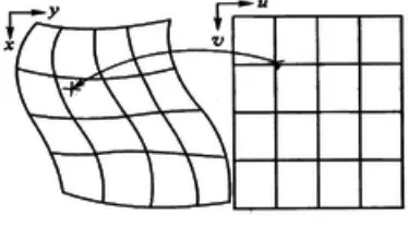
Geometric correction is the process of eliminating or correcting geometric errors of remote sensing images. In the process of imaging, the main causes of the geometric distortion of remote sensing images are the position and motion state of the remote sensing platform, the terrain fluctuation, the curvature of the earth's surface, the re-fraction of the atmosphere and the earth rotation, which are mainly represented by the extrusion, distortion, stretching and migration of the actual position of the pixel rela-tive to the ground target. Therefore, geometric correction is needed for these distor-tions [6-7]. The main methods of geometric correction are: remote sensing image correction based on polynomial, correction of remote sensing image based on colline-ar equation, remote sensing image correction based on rational function, and small surface element differential correction based on automatic registration. The geometric correction schematic diagram is shown in Figure 1.
Fig. 1. Geometric correction schematic
! !
! ! "
" # " # " #
$
!% & '
= =
=
" "
(2.1)! !
! ! "
" # " # " #
$
!% & '
= =
=
" "
(2.2)
Among them, x, y for pixel original image coordinates, X, Y as the correction of the ground coordinates, the different selection of n value, can get different spatial trans-formation. Theoretically, the greater the n value, the more the correction of complex geometric distortion, in practical applications, n usually takes less than 3 values. Then select the same name point (GCP) for image coordinate space transformation. N poly-nomial, select at least (n+1)*(n+2) /2 ground control point on the base image and the uncorrected image. In order to make the geometric correction result better, the num-ber of control points is far greater than the minimum numnum-ber, which can be 6 times as much as the minimum number. The selection of ground control points should follow the following principles: Based on the registration object, select the easily distin-guishable and accurate points on the image, such as the road intersection, the river fork, and so on; the image edge selects a certain number of feature points; the feature points should be evenly distributed on the whole image. Finally, the image pixel gray value resampling is carried out. In order to get the brightness values of each point on the image, the luminance value of each pixel in the image should be calculated ac-cording to certain rules, that is to resampling the image [8-10]. The commonly used methods are: nearest neighbor, bilinear interpolation and three convolution.
2.2 Cut line
The cutting line is in the inlay process, which exists in the overlapping area of two adjacent graphs, and a line is selected as the connection line of the two graphs accord-ing to certain rules. It can improve the problem which has a larger difference at the edge. The border lines usually choose rivers, roads, and other ground objects in over-lapping areas to avoid high altitude buildings, such as buildings, bridges, etc., and to draw cutting lines along the river or road.
2.3 Feather processing
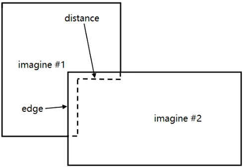
After geometric splicing, the corrected multiple images will form the entire image, which makes the edges of the entire image inlaid after the geometry become blurred, so that it can be well integrated into the image. According to the radius of feather, it can be feather along the edge or cut line. Therefore, feather can be divided into the emergence of edges and the cutting of line feathers.
im-age. At the distance of 10 pixels from the edge line, the top and bottom images will be mixed to calculate the output mosaic image using 50%.
Fig. 2. Principle map of cutting line feathering
Marginal feather. The principle of marginal feather is shown in Figure 3. The im-age is evenly processed according to the specified pixel distance. If the specified dis-tance is 20 pixels, 0% of the top image and 100% bottom image will be mixed at the edge to output the mosaic image. At the specified distance (20 pixels) from the side-line, there will be 100% top images and 0% bottom images to output mosaic images. At the distance of 10 pixels from the edge line, the top and bottom images will be mixed to calculate the output mosaic image using 50%.
2.4 Tone adjustment
In the process of image mosaic, it is necessary to avoid the phenomenon of color inconsistency and affect the effect of mosaic. Tone adjustment is an important part of image mosaic quality. Based on a pair of images, the histogram of each mosaic image is counted, and the histogram matching is used to match the other images, which makes the mosaic image have similar gray features.
3
Experimental analysis
3.1 Data description
In the use of ENVI software for image mosaic, it is necessary to edit the attributes of each image. When the mass image is operated, the process is more complicated and easy to miss the attribute editing of the image. If the selection of the base image is not appropriate, the image of the splicing failure will appear, so this paper proposes to use P in this paper. Python is used for batch image mosaic, and its running platform is ArcGIS 10.1.
Taking the DEM digital elevation data of Liaoning Province as an example, the lat-itude and longlat-itude of Liaoning province is N38° 43 '~N43° 26', E118° 53 '~E123° 13', so the digital elevation data of 10 ASTER GDEM V2 in N39_E121~N39_E12 and N40_E121~N40_E125 range are obtained, and their resolution is 30 m. In order to facilitate the program to identify the data source, first of all, the preprocessed DEM data file is named *dem.tif format, and then it is stored in the same folder.
3.2 Batch mosaic based on Python
Fig. 4. Image parameter information
4
Comparison and analysis of results
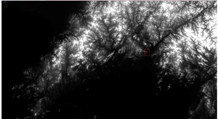
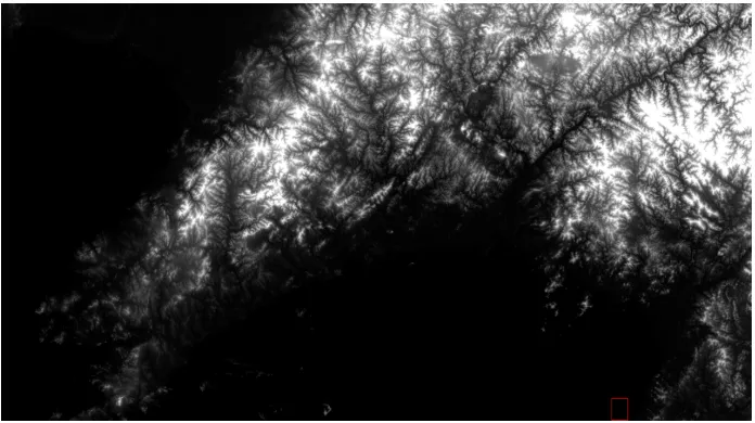
The results of the mosaic results of ENVI software and the results of batch mosaic using Python are compared in ENVI, respectively, as in Figure 5 and Figure 6, respec-tively, the results of the above two kinds of mosaic. The two mosaic results are opened in ENVI and linked together for comparison. Pixel information is slightly different, as shown in Figure 7. A slight difference in pixel information has little ef-fect on stitching efef-fect and can be ignored. In the later period, the fifteen images and twenty images were stitching and compared. In the software, the stitching failed be-cause of the improper selection of the reference image, and then the splicing image was modified to succeed. Through the completion time of two splicing methods, the time used for Python based stitching is based on 1/10 of the ENVI splicing, which can greatly improve the working efficiency, and it is easy to operate and is suitable for most of the working environment.
Fig. 6. Python splicing result
Fig. 7. Result contrast
5
Conclusions
on the Python interface of ArcGIS 10.1, and realizes the transition from multiple single images to target images. Through the contrast experiment of different numbers of images, it is found that the image stitching based on Python can improve the effi-ciency obviously on the premise of guaranteeing the accuracy, and can save the nec-essary time for the later image processing work, and it has certain guiding signifi-cance and reference value for similar image stitching.
6
Acknowledgment
This work was supported by National Key Research and Development Project of China [Grant Number 2016YFC0801602].
7
References
[1]Berni J A J, Zarco-Tejada P J, Suárez L, et al. Thermal and narrowband multispectral re-mote sensing for vegetation monitoring from an unmanned aerial vehicle[J]. (2009)IEEE Transactions on Geoscience and Remote Sensing, 47(3): 722-738. https://doi.org/10.1109/ TGRS.2008.2010457
[2]Shalaby A, Tateishi R. Remote sensing and GIS for mapping and monitoring land cover and land-use changes in the Northwestern coastal zone of Egypt[J]. (2007) Applied Geog-raphy, 27(1): 28-41. https://doi.org/10.1016/j.apgeog.2006.09.004
[3]Lee Y L, Tsai W H. A new secure image transmission technique via secret-fragment-visible mosaic images by nearly reversible color transformations[J]. IEEE Transactions on Circuits and systems for video Technology, 2014, 24(4): 695-703. https://doi.org/10.1109/ TCSVT.2013.2283431
[4]Mu E W, Lewin J M, Stevenson M L, et al. Use of digitally stained multimodal confocal mosaic images to screen for nonmelanoma skin cancer[J]. (2016)JAMA dermatology, 152(12): 1335-1341. https://doi.org/10.1001/jamadermatol.2016.2997
[5]Hernandez-Cabronero M, Marcellin M W, Blanes I, et al. Lossless Compression of Color Filter Array Mosaic Images with Visualization via JPEG 2000[J].(2018) IEEE Transac-tions on Multimedia, 20(2): 257-270. https://doi.org/10.1109/TMM.2017.2741426
[6]Boroomand A, Sekkati H, Lamm M, et al. Saliency-guided projection geometric correction using a projector-camera system[C] (2016)//Image Processing (ICIP), 2016 IEEE Interna-tional Conference on. IEEE: 2951-2955.
[7]Vreys K, Iordache M D, Biesemans J, et al. Geometric correction of APEX hyperspectral data[J]. (2016) Miscellanea Geographica, 20(1): 11-15. https://doi.org/10.1515/mgrsd-2016-0006
[8]Devlin J, Gupta S, Girshick R, et al. Exploring nearest neighbor approaches for image cap-tioning[J]. (2015) arXiv preprint arXiv:1505.04467.
[9]Gribbon K T, Bailey D G. A novel approach to real-time bilinear interpola tion[C]//Electronic Design, Test and Applications, Proceedings. DELTA 2004. Second IEEE International Workshop on. IEEE, 2004: 126-131.
8
Authors
Hongling Xiu is currently a master graduate student of University of Science and Technology Liaoning, Anshan, China, 114051, Her research interest includes remote sensing image processing and application ([email protected])
Fengyun Yang is currently a professor of University of Science and Technology Liaoning, Anshan, China, 114051, Her research interest includes GPS precision posi-tioning and remote sensing image processing ([email protected])