ISSN Online: 2161-7589 ISSN Print: 2161-7570
DOI: 10.4236/ojg.2019.97022 Jul. 19, 2019 327 Open Journal of Geology
Method of Non Destructive Geophysical
Mapping of the Environment
Olga Hachay
1, Oleg Khachay
21Institute of Geophysics, Ural Branch of Russian Academy of Sciences, Yekaterinburg, Russian Federation 2Ural Federal University, Yekaterinburg, Russian Federation
Abstract
Problem statement: The method of non-destructive testing is needed in dif-ferent aspects of geology, geomechanics and archeology, for instance: by test-ing the state of rock massifs in sault, kimberlites or rock shock mines, ancient archeological objects, or mapping for locating the wells drilling. The best method for solution these problems is based on using induction multi fre-quency electromagnetic field with use control sources on 3D planshet system of observation. Applied methods and design: Such method was developed at the Institute of Geophysics, Ural Branch of the Russian Academy of Sciences that allows its use to solve complex geological problems for mapping and monitoring the state of the environment. Its use allows the observation sys-tem to be used in such way that, on the one hand, it achieves flexible tunable detail of observations, and on the other hand, it organizes an input database that is close to the domain of definition of the inverse problem operator in the class of layered-block models with local hierarchical inclusions. This al-lows using regularization methods to obtain solutions that are in the class of equivalent, close to true. The specific possibilities of its use are determined by the technical side: the power of the excitation source, the sensitivity of the re-ceiving system. Typical results: It had been developed a new method of mapping, processing and interpretation, realized in a set of programs that al-low seeing the result of the searching structure of the environment in real time (that is after receiving some results during one day, we can see the re-sults of the geoelectrical features of the structure and the state of that part of the environment). It had been suggested a three staged conception of in-terpretation that can be used not only for inin-terpretation electromagnetic induction data and dynamic seismic data. Concluding note (Practical value/implications): In the considered case, this method contributed to the study of altered forms of kimberlitic bodies. The method underwent geologi-cal verification in various geologigeologi-cal conditions where it had been used for How to cite this paper: Hachay, O. and
Khachay, O. (2019) Method of Non De-structive Geophysical Mapping of the En-vironment. Open Journal of Geology, 9, 327-341.
https://doi.org/10.4236/ojg.2019.97022
Received: June 17, 2019 Accepted: July 16, 2019 Published: July 19, 2019
Copyright © 2019 by author(s) and Scientific Research Publishing Inc. This work is licensed under the Creative Commons Attribution International License (CC BY 4.0).
DOI: 10.4236/ojg.2019.97022 328 Open Journal of Geology mapping the geoelectrical structure. This allows us to offer a method for the development of innovative technology in the search for hydrocarbons in complex geological structures. The method was used in Egypt for research ancient archeological objects, located in Alexandria.
Keywords
Electromagnetic Planshet Method, Theory of Interpretation, Practice Use
1. Introduction
DOI: 10.4236/ojg.2019.97022 329 Open Journal of Geology sounding using a powerful pulsed magnetic dipole was made for the first time. The signal was recorded at a distance of up to 73 km and, despite the effects of surface heterogeneities, a variant of the section of the Urals crust and upper mantle was obtained by the electrical conductivity parameter. In the USSR, at that time, the MHD installations “Ural” and “Khibiny” were created, generating up to 50 - 100 MW in a short time and up to 10 - 20 MW in hundreds of hours. Research and development of MHD generators were widely deployed in the USSR, USA, Japan, Poland, India and other countries [17] [18] [19] [20]. Fur-ther progress in the development of geophysical methods of electrical explora-tion is associated with an increase in the depth of soundings; improved resolu-tion of methods; increasing productivity and reducing the cost of electrical ex-ploration; wide spread use of artificial (controlled) sources of primary fields. Such methods make it possible to obtain reproducible results at a convenient time for the researcher, putting the geophysical experiment into a number of ac-tive large-scale physical experiments [21].
In these paper it is developed new approach to process and interpret the data received for a new system of observation (planshet system), and in a new three staged concept of interpretation, that can be used not only for block layered model, but more complicated block layered model with hierarchical inclusions. That model is used now for testing the state of geological environment. More over that approach can be used for seismic dynamical system of observation.
2. New Concepts of Interpretation of Electromagnetic Fields
Data with Controlled Sources
DOI: 10.4236/ojg.2019.97022 330 Open Journal of Geology gravitational, magnetic, seismic, electromagnetic, thermal, here it is necessary take into account the thermodynamic relationship of the material parameters of the medium. Hence, the interpretation process no longer represents an inde-pendent solution of inverse problems for each field separately. The operator of the inverse problem with complex interpretation is written out in the form of a system of equations for the fields connected by thermodynamic material rela-tions. Examples include the algorithms for determining the mechanisms of con-vection in the Earth’s mantle, the interpretation of natural-field anomalies asso-ciated with electro kinetic phenomena [25]. The theory of interpretation of geo-physical fields is directly related to the solution of ill-posed problems and the theory of regularization had been created by the works of A.N. Tikhonov, V.K. Ivanov, M.M. Lavrentiev and their schools. As a result of its application, impor-tant results have been achieved in constructing models of local, regional and global distributions of physical properties in the Earth and other celestial bodies on which geophysical studies were carried out, within the framework of piece-wise homogeneous models and a linear approximation to describe field propaga-tion. The further development of geophysical methods in the direction of build-ing more and more adequate models of environments and phenomena necessar-ily leads to more and more complex problems of mathematical geophysics, for which not only the inverse, but also direct problems become essentially incorrect [26] [27]. In this regard, on the one hand, it is necessary to develop a new con-cept of regularization for the simultaneous solution of a system of different types of operator equations. On the other hand, another approach is possible: the cre-ation of equal-type interpretcre-ation algorithms based on solving equal-type oper-ator equations that differ in the explicit form of the kernel of integral equations.
Using the second approach and the ideas of A.V. Tsirulskiy about a two-stage interpretation of potential stationary fields, we created a unique concept of three-stage interpretation electromagnetic and seismic fields [27]. In this con-cept, the idea of filtering the input data into the domain of definition of the solu-tion of a one-dimensional inverse problem operator and the idea of approx-imating anomalous fields with a class of fields with predetermined properties [28] is used for regularization. Algorithms that implement all the stages of inter-pretation have been developed, allowing investigating the applicability of this approach to the analysis of practical data [27] [28]. For the simultaneous use of data from various fields, the basic principles of the construction of a real obser-vation systems were developed, allowing, on the one hand, to obtain a database consistent in the normal field, on the other hand, to realize 3D interpretation in the framework of unified algorithms. Examples of practical application indicate the high information content of the proposed integration [29] [30].
Consider the component parts of this concept:
1) At the first stage, the electromagnetic and seismic parameters of the hori-zontally layered-block medium are determined, containing elastic and geoelec-trical heterogeneities.
DOI: 10.4236/ojg.2019.97022 331 Open Journal of Geology immersed in the medium (with the physical parameters determined at the first stage) of singular sources that are equivalent in terms of the field to local geoe-lectrical and elastic heterogeneities. At the same time, a geometric model of in-dividual local heterogeneities or groups and their mutual arrangement inside a layered-block containing medium are determined.
3) At the third stage, the surfaces of the desired heterogeneities are deter-mined depending on the values of the physical parameters of the anomalous ob-jects.
3. Practical Implementation of the New Concept
The following theoretical and practical results were obtained in the paper [28]: 1) A unified observation system for alternating electromagnetic and seismic fields using a local excitation source has been developed and tested. The choice of the type of excitation source was determined by the following: a) a uniform geometry of the normal field, b) the absence of one or several components in the measured field in the case of a quasi-layered medium. Such properties in the case of the electromagnetic field have a vertical magnetic dipole, in the case of a seis-mic field—a vertically acting force. The presence of a local source of excitation allows regularly for a given network of observations to realize overlaps at differ-ent angles of visibility (the source of excitation towards the heterogeneity). Three components of the magnetic field and three components of the field of elastic displacements as functions of spatial coordinates and time are used as input data for interpretation. For ground-based observations, the data are rec-orded on the day surface for a set of distances between the source and receiver as a function of time. Analysis of the solution of direct problems for seismic and electromagnetic cases, showed [29] [30] that a single computational approach can be realized when interpreted after a preliminary transfer of electromagnetic data to the real axis, and seismic to an imaginary axis of the complex frequency plane. In this case, the whole further process of interpretation must be con-ducted on this plane, without going back to the time domain.
anomal-DOI: 10.4236/ojg.2019.97022 332 Open Journal of Geology ous fields, the system of singular sources in the form of closed current con-tours—horizontal magnetic dipoles—is preferable for the electromagnetic field. Despite the fact that both systems are complete and suitable for the selection of anomalous electromagnetic fields, with joint integrated interpretation of seismic and electromagnetic fields, in addition to changing the design type, it makes sense to introduce an additional parameter in the electromagnetic case, which is the ratio of electrical horizontal components ρ and φ, the spatial distribution of which is more closely related to the distribution of the seismic heterogeneity pa-rameter in its shear part and therefore in electromagnetic case it is necessary to measure further components of the horizontal electric or magnetic field corres-ponding derivatives. Algorithms that implement all the stages of interpretation have been developed, allowing investigating the applicability of this approach to the analysis of practical data [29] [30]. For the simultaneous use of data from different fields, the basic principles of the construction of a real observation sys-tems were developed, allowing, on the one hand, to obtain a database harmo-nized across the normal field, and on the other hand, to realize 3D interpretation in the framework of unified algorithms. Examples of practical application indi-cate the high information content of the proposed integration [31] [32] [33]. The implementation of the described methodology is carried out using the A.I. Che-lovechkov equipment developed for shallow induction electromagnetic research, as well as Sinus seismic equipment developed by L.N. Senin at the Institute of Geophysics, Ural Branch of the Russian Academy of Sciences. Thus, the Institute of Geophysics has developed a 3-D electromagnetic planshet frequency-geometric, instrumental-methodical and interpretational complex based on a controlled ex-citation source in the form of a vertical magnetic dipole, implemented as an strument complex, a planshet observation system, programs for processing, in-terpretation and visualization in view 3-D models of the data. The equipment was created by Ph.D. A.I. Chelovechkov, methodology, theory of interpreta-tion—Dr. Sc. O.A. Hachay, software implementation—Ph.D. Khachay A.Yu., Ph.D. Khachay O.Yu.
4. Practical Use of a Planshet Technique Using Induction
Electromagnetic Technique
hydro-DOI: 10.4236/ojg.2019.97022 333 Open Journal of Geology carbon deposits in Western Siberia quite definitely testifies of a significant loca-lization of oil and gas in the structure of deposits. The transverse dimensions of local deposits of high flow wells often do not exceed several hundred meters and are separated by hydro dynamically impermeable rocks that retain the primary structure of clay sediments [35]. On the Yamal semi island, in the regional plan, a linearly elongated strip of sub-vertical zones of destruction is distinguished, extending from the north-north-west to south-southeast of the Nurminsky shaft axis and controlling all major hydrocarbon fields in this area. After crossing the southern part of the Ob Bay, its continuation in Western Siberia is clearly visible ([35] see bibliography).
The high degree of localization of increased productivity sites associated with sub-vertical zones of destruction can be judged by the example of the Yem-Egovsky field (Western Siberia): on a plot of 1 sq. million km one of about 100 wells gave 95% of all oil produced. Small transverse dimensions of the reservoir area, high production rate and total cumulative production completely determine the field-geological model of this field and its analogues in a new way. Such a model is rather similar to the model of a vein ore or diamond ferrous deposit [35].
5. Illustration of the Implementation of the Developed
Methodology in the Diamond-Bearing Province
Let us give an example of its use in the Krasnovishersk region of the Perm domain.
5.1. Geological Description of Krasnovishersk Perm Domain
DOI: 10.4236/ojg.2019.97022 334 Open Journal of Geology and in these craters are blocks of Takata sandstones that are far from contact, surrounded by carbonate rocks. The rocks of the Takata formation are represented on the deposit by gravelites, coarse-grained sandstones and interlayers of green-white unlithified clays with a thickness of 1.5 - 2.0 m, layered down with quartz sandstones with a thickness of 0.1 - 0.15 m. At the base of the section, lenses of rarely-pebble conglomerates with sizes up to several meters and with a thickness of up to 0.2 m. The origin of such lenses is connected, apparently, with the destruction of more ancient conglomerates and canning of debris formed during weathering in quartz sandstone and in gravelites. The produc-tive horizon is disintegrated quartz sandstone and gravelites of the Takata suite, which lie on the karsted surface of the limestone of the Kolchim suite, separated from the massive limestone by a layer of karst clay. Separate di-amond crystals had been found in massive sandstones. The disintegration of sandstones occurs not only where the contact of carbonates and sandstones reaches the surface, but also at depth, and massive sandstones, as a rule, lie on the disintegrated ones.
The presence of karst and karst carbonate clays under Takata quartz sand-stones allows us to conclude that the weathering crust, which is fixed at depth, along the contact surface of Takata and Kolchim deposits, is Paleozoic, formed before the formation of sandstones and Takata gravelites, which within the Kol-chim anticline also represent continental formations. The same conclusion was reached by Y. Becker and co-authors based on a study of the lithology of the de-posits of the Takata suite and the geological structure of the diamond ferrous placer at the Ishkovskiy open-pit (career) mine [37] [38]. The Mesozoic and Cenozoic weathering processes are superimposed on the Paleozoic weathering crust, especially strongly developed at the contact of carbonate rocks with sand-stones that extend to the surface. The occurrence of the productive horizon in the Paleozoic weathering crust and its overlapping with deposits of the Takata formation allows us to consider the Ishkovskiy open-pit mine as an ancient Pa-leozoic alluvial deposit [39].
DOI: 10.4236/ojg.2019.97022 335 Open Journal of Geology the main structural factors and criteria of the state of the geological environment. The technique used refers to the geophysical methods of non-destructive testing. It differs from previously known methods of x-ray or tomography observation systems and the subsequent method of interpretation. These results made it possible to establish an important morphological factor: diamond ferrous areas in the form of placer deposits gravitate to high-resistance structures, which are either the sources themselves or are structures that block the spreading and fur-ther movement of diamonds. These structures are mapped to depths of 70 - 100 m and deeper. The use of methods commonly used for in-depth studies does not allow them to be distinguished with sufficient resolution. It turns out a fairly uniform resistance section, which is a consequence of the integration of high and low-resistance structures. The resulting geoelectrical cuts in kimber-lites strata are high-resistance with a resistance comparable to the resistance of high-resistance structures controlling the developed placers. In addition, the ap-plied technology allowed identifying new depressions, thereby expanding the area of possible diamond mining. One of them is confirmed by detailed geologi-cal borehole verification. It is located on the Northern Rassolnaya placer [40]. The obtained data of geological-geophysical structure and diamond-bearing na-ture of the rocks of the Kolchimsky anticline suggest that the primary sources of diamonds are found in pre-Silurian sediments, and their age, taking into account the fact that the Pomenennovskaya and Poldovskaya formations fall out of the Paleozoic section, is not less than 670 million years. With the destruction of primary sources, diamonds were initially concentrated in terrigenous sediments of the Kolchim Formation, and during erosion of these sediments they fell into the base of the Takata formation. It is possible that the ancient diamond ferrous placers can be found in terrigenous sediments of the Kocheshor suite or in the upper part of the section of the Ilyavozh suite. If this assumption is true, then indigenous sources should be sought in the rocks of the Kocheshor, Ilyavozh and more ancient suites, but this causes another problem that complicates the search for indigenous sources. Rocks of Kocheshor and more ancient suites underwent deformation and their primary horizontal occurrence changed to sub vertical. According to E.V. Shipilova, the deformation is associated with the Baikal oro-genesis, manifested within the Timan-Pechersk Plate. The bodies of kimberlites must undergo a corresponding transformation if they were introduced before the folding stage. Naturally, after such a transformation, traditional methods of searching for kimberlites in the area of Krasnovishersk diamond deposits are not suitable.
5.2. Geophysical Results Using the Planshet Methodology
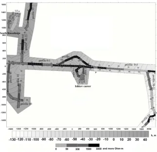
DOI: 10.4236/ojg.2019.97022 336 Open Journal of Geology In Figure 1 we can see the whole profiles that had been developed using the method of wide profiles that are presented as a part of a planshet system. We see also the place Ishkov career, where had been developed and used the area plan-shet system. The same system had been developed at the placer South Rassol-naya, for what the geoelectrical sections agreed with the drilling data. That result allows us to develop the whole work for mapping the areas of diamond deposits for instance in the Ishkov career.
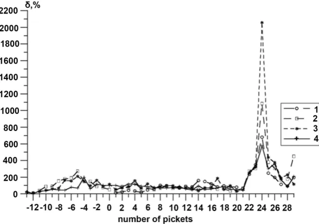
In Figure 2 we can see a fragment of the geoelectrical section of the profile 0 - 1. We see that the structure is very blocked and the resistivity of them differs from 20 - 5000 ohm∙m. We can see the part of the profile (pickets 26-28) is very conductive. Really from Figure 3 we see that for these pickets we observed very high parameter of heterogeneity that corresponds with the geological fault.
That work was performed jointly with the Institute of Mineralogy, Ural Branch of the Russian Academy of Sciences under the guidance of Correspond-ing Member of the Russian Academy of Sciences V.N. Anfilogov with the sup-port of the Russian Foundation for Basic Research, project 04-05-64136.
[image:10.595.212.536.371.684.2]In addition, we carried out parametric electromagnetic studies in the frame-work of the same technology in the kimberlites mines International and Aikhal in Eastern Siberia.
DOI: 10.4236/ojg.2019.97022 337 Open Journal of Geology Figure 2. The resistivity section along the part of the profile 1 (Figure 1).
Figure 3. The distribution of the parameter heterogeneity along the part of profile 1 (Figure 1). Legend: 1 - 20.3 kHz, 2 - 5.08 kHz, 3 - 1.27 kHz, 4 - 635 Hz.
[image:11.595.208.537.342.573.2]imple-DOI: 10.4236/ojg.2019.97022 338 Open Journal of Geology mentation are determined by the technical side: the power of the excitation source, the sensitivity of the receiving system. In the considered case, this me-thod contributed to the study of modified forms of kimberlites bodies, which arose during the evolution of the diamond-bearing province. The method un-derwent geological verification in various geological conditions. This allows us to offer a method for the development of innovative technology in the search for hydrocarbons in the complex geological structures of Yamal and adjacent terri-tories.
6. Conclusion
The new approach, which forms the basis of an integrated seismic and electromagnetic research method, has shown its viability and practical significance in the study of rock massifs of various material compositions. Seismic and electromagnetic information is mutually complementary in the mapping and prediction of the behavior of an array that is under technogenic influence. It relies on the use of active methods of geophysical monitoring using controlled concentrated sources of excitation, allowing spatial movement along a given observation system with overlapings. The complex technique has a high resolution that does not concede to tomographic studies, and the created software allows you to restore the volume geoelectric and seismic model of the array, which is used to calculate the volume distribution of the stress tensor in the array [23] [41] [42]. The implementation of the technique can, with a decrease in the excited and measured frequencies of an alternating magnetic field with a given detail, either directly map the structure of the hydrocarbon deposit, or use the detailed seismic information on these zones for setting indus-trial wells with a sharp reduction in additional preliminary drilling. Currently, such equipment is available in the IGF UB RAS. The developed planshet induc-tion technique using a controlled source of excitainduc-tion was included in the com-plex of electromagnetic methods used in the Arab Republic of Egypt for solving problems of shallow geophysics and archeology [43] [44].
Conflicts of Interest
The authors declare no conflicts of interest regarding the publication of this pa-per.
References
[1] Einstein, A. (1967) V1. Science, Moscow.
[2] Zhdanov, M.S. (2010) Electromagnetic Geophysics: Notes from the Past and the Road Ahead. Geophysics, 75, 75A49-75A66.https://doi.org/10.1190/1.3483901
[3] Bulashevitch, Y.P. (2014) The Founder of academic Geophysics in the Urals. RIO UB RAS, Ekaterinburg.
[4] Bursian, V.R. (1972) The Theory of Electromagnetic Fields Used in Electrical Pros-pecting. Nedra, Leningrad.
DOI: 10.4236/ojg.2019.97022 339 Open Journal of Geology
[6] Velikin, A.B. and Frantov, G.S. (1962) Electromagnetic Fields Used in Inductive Methods of Electrical Prospecting. Review of Foreign Literature. Gostoptekhizdat, Leningrad.
[7] Kormiltsev, V.V. and Mezentsev, A.N. (1989) Electro Prospecting in Polarizing Me-dia. Ural Branch of the Academy of Sciences of the USSR, Sverdlovsk.
[8] Svetov, B.S. (1973) Theory, Methods of Interpretation of Materials of Low-Frequency Inductive Electrical Prospecting. Nedra, Moscow.
[9] Sidorov, V.A. (1985) Impulse Inductive Electrical Prospecting. Nedra, Moscow. [10] Tabarovsky, L.A. (1975) Application of the Method of Integral Equations in
Prob-lems of Geoelectrics. Nauka, Novosibirsk.
[11] Aksenov, V.V. (2002) Electromagnetic Field of the Earth. SB RAS, Novosibirsk. [12] Nazarny, S.A. and Komarov, V.A. (2001) Caused Seism Electric Polarization. VIRG,
S.P. University, Saint Petersburg.
[13] Svetov, B.S. (2007) Foundations of Geoelectrics. TsGEMI RAN, Moscow.
[14] Berdichevsky, M.N. and Dmitriev, V.I. (2009) Models and Methods of Magnetotel-lurics. Scientific World, Springer,Berlin, Heidelberg.
https://doi.org/10.1007/978-3-540-77814-1
[15] Kaufman, A.A. (2000) Introduction to the Theory of Geophysical Methods. Elec-tromagnetic Fields. Nedra. Moscow.
[16] Astrakhantsev, G.V. (1988) Induction Sensing in the Study of Contrasting in Elec-trical Conductivity Environments. UB RAS, Sverdlovsk.
[17] Astrakhantsev, G.V., Babakov, Y.P., Bulashevitch, Y.P., et al. (1977) Induction Sounding of the Earth’s Crust in the Urals Using MHD Generator. DAN USSR, 237, 808-812.
[18] Astrakhantsev, G.V., Dyakonov, B.P., Bulashevitch, Y.P., et al. (1979) The Study of the Electrical Conductivity of the Earth’s Crust in the Urals. Izvestiya USSR Acad-emy of Sciences. Physics of the Earth, 1, 15-26.
[19] Velikhov, E.P. and Volkov, Y.M. (1982) Prospects for the Development of Pulsed MHD Energy and Its Application in Geology and Geophysics. In Deep Electromag-netic Sounding Using Pulsed MHD Generators, Academy of Sciences of the USSR. Apatity, 5-25.
[20] Gorbunov, G.I., Belkov, I.V., Pavlovsky, V.I., Zhamaletdinov, A.A., et al. (1979) Deep Electromagnetic Sounding with an MHD Generator on the Kola Peninsula.
DAN USSR, 247, 578-582.
[21] Hachay, O.A. (2002) Ideas Yu.P. Bulashevich in Modern Understanding of the Problem of Integration of Geophysical Methods. Ural Geophysical Bulletin, IGF,
Ural Branch of the Russian Academy of Sciences, 3, 42-46.
[22] Bulashevitch, Y.P., Dyakonov, B.P., et al. (1980) Methods and Results of Building a Complex Model of the Earth’s Crust and Upper Mantle of the Urals. In: Tektonos-phere of Ukraine and Other Regions of the USSR, Kiev, 181-195.
[23] Hachay, O.A. (2000) Complex Geophysical Studies (Theory and Practical Results)
Ural Geophysical Bulletin IGF UB RAS, 1, 107-110.
[24] Hachay, O.A. and Khachai, Y.V. (1993) On the Identification of the Physical Me-chanisms of Mantle Convection Based on the Inverse Problem Method. Geology and Geophysics, 6, 15-21.
DOI: 10.4236/ojg.2019.97022 340 Open Journal of Geology
[26] Samarsky, A.A. and Kurdyumov, S.P. (1989) Paradoxes of the Multivariant Non-Linear World-The World around Us. Hypotheses and Forecasts M.: Know-ledge, 8-29.
[27] Hachay, O.A. (1996) Three-Stage Method of Interpretation of Variable Electro-magnetic Fields and Its Practical Implementation. In: Electromagnetic Research with Controlled Sources. RAS, St. Petersburg, 30-31.
[28] Hachay, O.A. and Novgorodova, E.N. (1997) The Experience of Areal Induction Studies of Highly Inhomogeneous Geoelectric Media. Physics of the Earth, 5, 60-64. [29] Hachay, O.A. (1980) Unified Method for Solving the Inverse Problem of Electro-magnetic Soundings for a One-Dimensional Medium. Izvestiya USSR Academy of Sciences. Physics of the Earth, 5, 51-60.
[30] Hachay, O.A. (1991) On the Solution of the Inverse Problem for Three-Dimensional Variable Electromagnetic Fields. Izvestiya Academy of Sciences USSR. Physics of the Earth, 6, 50-57.
[31] Hachay, O.A., Novgorodova, E.N. and Bodin, V.V. (1999) On the Problems of Shallow Geoelectrics and Some Results of Their Solution. Physics of the Earth, 5, 47-53.
[32] Hachay, O.A and Druzhinin, V.S. (2000) Integrating Three-Dimensional Methods of Seismic and Electromagnetic Research to Solve Monitoring Problems. Explora-tion and ProtecExplora-tion of Mineral Resources, 2, 22-24.
[33] Hachay, O.A., Novgorodova, E.N. and Khachai, A.Y. (2000) Mapping of Three- Dimensional Conducting Zones Using Areal Observation Systems in the Frame-work of the 3-D Frequency-Geometric Technique. Geology and Geophysics, 41, 1331-1340.
[34] Hachay, O.A., Novgorodova, E.N. and Khachai, A.Y. (2003) Investigation of the Resolution of the Planshet Electromagnetic Method for Active Mapping and Moni-toring of Heterogeneous Geoelectric Media. Physics of the Earth, 1, 27-37.
[35] Megerya, V.M. (2009) Search and Exploration of Hydrocarbon Deposits Controlled by Geosoliton Degassing of the Earth. Locus Standy, Moscow.
[36] Anfilogov, V.N., Korablev, A.G. and Kabanova, L.Y. (2001) Features of the Geolog-ical Structure and Genesis of Krasnovishersk Diamond Deposits. In: Diamonds and Diamond Content of the Timan-Pechersk Region, Geoprint, Syktyvkar, 69-71. [37] Becker, Y.R., Bekasova, N.B. and Ishkov, A.D. (1970) Diamond Ferrous Placers in
the Devonian Sediments of the Northern Ural. Lithology and Minerals, 4, 65-75. [38] Sokolov, B.N. (1982) Formation of Placers of Diamonds. Science, Moscow.
[39] Shuysky, V.P. (2000) Paleontological characteristics of the Takata Formation of the Krasnovishersk District (Northern Ural). In Yearbook 1999: Information Collection by the Institute of Geology and Geochemistry, Yekaterinburg, 31-35.
[40] Hachay, O.A., Khachai, O.Y. and Kononov, A.V. (2008) The Use of New Geophysi-cal Technology in the Study of the Relationship of the Primary Source and Placer of Diamonds. Exploration and Protection of Mineral Resources, 2, 58-60.
[41] Hachay, O.A. (1997) The Three-Stage Concept of Common Interpretation for 3-D Electromagnetic and Seismic Fields and Some Results of Its Practical Realization.
Engineering and Environmental Geophysics for the 21st Century, China, Chengdu, 286-292.
DOI: 10.4236/ojg.2019.97022 341 Open Journal of Geology
[43] Atya, M.A., Hachay, O.A., Abdel Latif, A., et al. (2010) Geophysical Contribution to Evaluate the Hydrothermal Potentiality in Egypt: Case Study: Hammam Pharaoh and Abu Swiera, Sinai, Egypt. Earth Sciences Research Journal, 14, 44-62.
[44] Atya, M.A., Khachay, O.A., Soliman, M.M., et al. (2010) CSEM Imaging of the Near Surface Dynamics and Its Impact for Foundation Stability at Quarter 27,15th of May