Forestry & Natural-Resource Sciences Last Correction: Sep. 30, 2016
SPATIOTEMPORAL DATA MODELLING FOR CHINESE FOREST
GEO-ENTITY SUB-COMPARTMENT
Kai Xia
1,2Jun Peng
1 1School of Information Engineering; 2Zhejiang Provincial Key Laboratory of Forestry Intelligent Monitoring
and Information Technology Research.
Zhejiang Agriculture and Forestry University, Lin’an 311300, China
Abstract. Sub-compartment, the most significant type of forest geo-entity, is the basic unit of
forest management in China. Apart from having a certain shape, the sub-compartment has social attributes, such as ownership, as well as natural attributes, such as tree species, stand volume, and average diameter at breast height (DBH). The evolution of the sub-compartment is a spatiotemporal process that involves gradual and abrupt changes. A forest resource spatiotemporal data model is designed based on a spatiotemporal expression method named sequence states which could express the spatiotemporal evolution process that involves gradual and abrupt changes. The example shows that when the data from the entire region or from a few sub-compartments are updated, all of them can be stored and related well in the database constructed based on our model. Not only the history of a sub-compartment but also its ancestor sub-sub-compartments can be retrieved and displayed on the client window. The controls, space-time cube and history tree, are designed to visualize the evolution of sub-compartments.
Keywords: spatiotemporal data model; sequence states with no fixed frequency; forest resource; forest
management, history tree, space-time cube
1
Introduction
Spatiotemporal research has been applied in numer-ous fields, e.g., cadastral management and transportation. However, in forest resource management, the spatiotem-poral data model has not been studied extensively. The reason lies in the lack of suitable spatiotemporal evolu-tion expression method for forest resource spatiotemporal modelling.
Currently, the snapshots method and event method being used are the typical spatiotemporal evolution ex-pressing methods. The snapshots method introduced by Langran (1988) is used to represent spatiotemporal evolution by a sequence of snapshots. The method is simple and available but weak in data association. The event method introduced by Peuquet (1994) can be used to record and express abrupt change. Events can be counted as the driver of data updating and the unit of data organisation.
In the field of forest management, the two methods have been both used so far, e.g., the data products of for-est management surveys in China are organised as
snap-shots stored in the forest departments at all levels. The forest resource data model based on the event method, which can represent the abrupt change in the spatiotem-poral evolution, has been studied by Gao (2007 2008) and other Chinese researchers (Tang, Tang & Hu 2008; Zhao, Li & Wang 2012 ). However, these models did not consider the evolution of nature attributes, such as stand volume and average DBH. Thus, the model was imperfect. Rasinmaki (2003, 2007) proposed a conceptual spatio-temporal model in hierarchical structure to represent the evolution of the environmental spatial objects and applied it to manage multi scale of forest resource data. But these works are not based on the present situation of forest management in China. Other spatio-temporal modelling works related to environment are available in the papers (Mari & Benoˆıt 2013; Pinet, 2012; Gebbert & Pebesma 2014).
A forest resource spatiotemporal data model is de-signed in this paper based on a spatiotemporal express method named sequence states, which is the combination of the snapshots and event methods.
2
Spatiotemporal Process Analysis of
Forest Geo-Entity
Spatiotemporal process, the foundation of spatiotem-poral modelling, is a concept developed to represent the changes of geo-entity occurring in both space and time (National Administration of Surveying, Mapping and Geoinformation 2012). Geo-entity is a category of natural or artificial geographical features with common characteristics (Claramunt, Parent & Th´eriault 1997). Sub-compartment is the basic unit of forest resource survey, statistics and management.
The sub-compartment, as a category of geo-entity, has a shape of its own. The area of the shape is not the same in every province in China, e.g., in Zhejiang Province, the area is from 0.4 ha to 15 ha (Monitoring Center for Forest Resources in Zhejiang Province 2008), and in Heilongjiang Province, the area is from 0.4 ha to 20 ha (Liu et al. 2011). A large number of attributes, such as ID, ownership, right to use, terrain, cover degree, forest class, site level, community structure, land type, dominant tree species and forest stand factors (including average tree height, average DBH, stand volume and canopy) belong to the sub-compartment (Monitoring Centre for Forest Resources in Zhejiang Province 2004). The concept of the sub-compartment is different from stand because every piece of land in the Chinese forest map, including non-forest land, is considered to be a kind of sub-compartment.
In the following sections, this paper discusses the spatiotemporal process of the sub-compartment from three aspects: 1. spatial relationship feature; 2. temporal feature; and 3. spatiotemporal evolution feature.
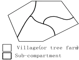
Village(or tree farm) Sub-compartment
Fig 1 Relation between GeoEntity Figure 1: Relation between GeoEntity.
1. Spatial Relation Feature: The sub-compartment
must belong to a village (or tree farm). Therefore, the shape of a village or a tree farm is divided into polygons which are the shapes of the sub-compartments. The shapes of sub-compartments do not overlap with one another, and no gap exists between them (as shown in Fig. 1).
2. Temporal Feature: The sub-compartment has a
life cycle characterised by creation, development, and extinction.
3. Spatiotemporal Evolution Feature: The
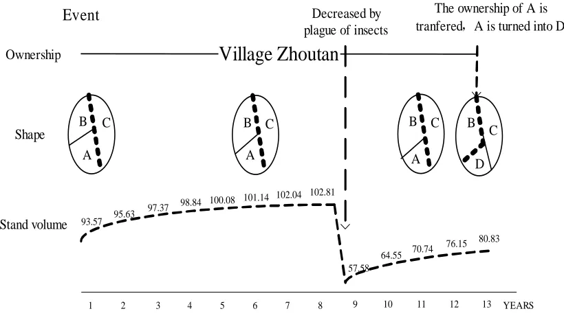
evo-lution of the sub-compartment can be described from four aspects: (1) several attributes, such as ID and ownership, are not changed in the life cycle of the sub-compartment. As shown in Figure 2, the change in the ownership of sub-compartment A, which has not been changed previously, leads to the extinction of the sub-compartment in its 13-th year. (2) The boundary divisions of 13-the shape are related to various factors such as ownership, right to use, land type, forest stand factors, and tree species. The boundary divided by the tree species does not match the actual situation over time. Under normal conditions, the boundary ad-justs every 5 or 10 years to keep the boundary of the sub-compartment in accordance with the natural boundary of the tree species. Figure 2 illustrates that the boundary between A and B is moved twice and that the course can be considered as a type of gradual change. By contrast, the shape is abruptly changed by an event such as fire or administrative boundary transfer. (3) Certain attributes, such as dominant tree species and community structure, change in a discrete step during the life cycle of the sub-compartment. (4) As shown in Figure 2, for-est stand factors, such as stand volume and DBH, continuously and gradually change under normal conditions. However, they can also change abruptly, e.g., in the ninth year, the stand volume decreases by a wide margin because of pests.
The evolution of the sub-compartment is a spatiotem-poral process that includes gradual change and abrupt change. Under normal conditions, the stand volume, DBH, and shape gradually change. However, at a specific time, the sub-compartment changes remarkably. After the abrupt change, the sub-compartment returns to the process of gradual change.
3
Spatiotemporal Evolution Expression
Method
In this section, a spatiotemporal evolution method named sequence states, which was proposed by Xia et al. (2013), is introduced to represent the spatiotemporal process of the forest geo-entity sub-compartment.
3.1 Snapshot Method and Event Method A large
Village Zhoutan
OwnershipEvent
Stand volume A
C B
Decreased by plague of insects
The ownership of A is tranfered,A is turned into D
Shape
A C
B B
C
D
1 2 3 4 5 6 7 8 9 10 11 12 13
A C B
93.57 95.63
97.37 98.84 100.08
101.14 102.04 102.81
57.58
64.55 70.74
76.15 80.83
YEARS
Fig 2 The Spatio-Temporal Evolution of Sub -Compartment
Figure 2: The Spatio-Temporal Evolution of Sub-Compartment.SnapsShot1
A) Shape in gradual changing
SnapsShot2 SnapsShot3
B) Attribute in gradual changing 28.1
28.5 28.3
28.6
28.9 28.6
29.1
29.3 29.1
Fig 3 Snapshots method and gradual change Figure 3: Snapshots method and gradual change.
and event method. These two methods have numerous similarities and differences, which are presented in Table 1(Xia et al. 2013).
As shown in Figure 3-A, three snapshots express the evolution of a region. However, no data are available to record the reason for the change, which should be analysed by the researcher. This method is used in re-mote sensing image management more frequently. Figure 3-B shows another form of snapshots in which the shape
of the geo-entity does not change but the attribute at-tached to the shape changes gradually. Sometimes this method is called “sequence data,” which is used in the meteorological, hydraulic and forest fields, to name a few.
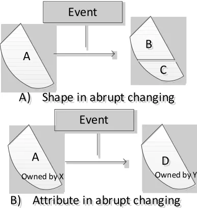
Figure 4-A shows mutational events in which geo-entity A is divided into two entities: geo-geo-entity B and geo-entity C. In addition to the states of geo-entities, the details of the change are recorded in the event object. This method is widely applied in cadastral and land use management. Sometimes, the shape is not changed but the attribute is changed, which is also recorded in the event object, as shown in Figure 4-B.
3.2 Sequence States Method Usually, the snapshot
method and the event method are used independently. As mentioned, the spatiotemporal process of forest geo-entity includes gradual change and abrupt change. A single method is insufficient to express the process.
Table 1: Difference between snapshot and event methods.
Snapshot Event
Frequency Fixed time Real-time update
Scope All geo-entity Geo-entity evolved in event
Application character Express gradual change, analyse abrupt change (Liu 2004) Express abrupt change
B
B
C
C
A
A) Shape in abrupt changing
A) Shape in abrupt changing
Event
A
D
D
Event
B) Attribute in abrupt changing
B) Attribute in abrupt changing
Owned by X Owned by Y
Figure 4: The method of Event and abrupt change.
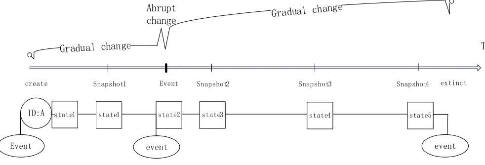
represented by an ID with a series of states. The ID represents the entity itself. Certain states are added at intervals to its life cycle, whereas others are inserted after a mutational event to record change. An event object, connected with the state, is created to record information on the event.
The spatiotemporal evolution expressing method, which can be used to express the process that includes gradual change and abrupt change, is called sequence states. The geo-entity is considered as a set of states, as shown in Expression (1).
Geo−Entity= {id,Xstatei} (1)
‘State’ comprises shape and all other attributes, as shown in Expression (2).
State= {Shape,XAttributei} (2)
‘State’ has time duration (Td), which lasts from ‘be-gin time’ (Tbe‘be-gin) to ‘end time’ (Tend), as shown in Expression (3).
StateT d=StateT begin−StateT end (3)
In the state sequence, the ‘end time’ of the state is equal to the ‘begin time’ of the next state.
Statei+ 1.tbegin=Statei.tend (4)
The main ideas behind the methods are as follows: (1) Geo-entity consists of the process of creation, develop-ment, and extinction. (2) The creation and extinction of the geo-entity, which characterise typical abrupt change, can be represented by an event. (3) The development of a geo-entity is represented by a series of states. A state depicts a geo-entity in a single moment. The time interval between states is not fixed.
4
Object-oriented Forest
Spatiotempo-ral Data Model Based on Sequence
States
In this section, an object-oriented forest spatiotempo-ral data model including its spatiotempospatiotempo-ral constraints was put forward.
4.1 Layering and Expressing of Spatiotemporal
Process of Sub-compartment As mentioned, the
evo-lution pattern and evoevo-lution speed of the different parts of the sub-compartment are not the same. Therefore, classifying the shape and attributes is necessary to form certain layers. The layering aims to construct differ-ent layers in differdiffer-ent intervals of sequence, reduce data redundancy, and make the expression reasonable.
7
*UDGXDOFKDQJH
*UDGXDOFKD
QJH
$EUXSW
FKDQJH
(YHQW 6QDSVKRW
6QDSVKRW 6QDSVKRW 6QDSVKRW
VWDWH
,'$ VWDWH VWDWH VWDWH VWDWH
HYHQW
VWDWH
HYHQW (YHQW
FUHDWH H[WLQFW
Figure 5: Sequence States: group of the snapshots methods and the events methods.
average DBH, and average tree height, exhibit consecu-tive and gradual change. Because the data between two years are clearly different, annual updating is conducted to represent evolution. The frequency of change is higher than the shape and discrete attributes..
The sub-compartment can be expressed as follows:
Sub-compartment={ID&Constant Attributes,
X
States} (5)
States= X{Shape&DCAttributes,
X
Stand F actors}
(6)
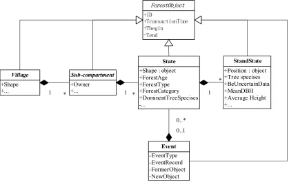
4.2 UML Graph Figure 6 presents a simple UML
(Unified Modelling Language) graph of the object-oriented forest spatiotemporal data model designed based on the sequence states that combines the features of the snapshot and event methods. The UML graph aims to describe the relationship between sub-compartment, state, stand state, and event object. We have observed the following conditions: (1) The ForestObject is the superclass of vil-lage, Sub-compartment, State and Standstate, and they all inherit the attributes and operations of ForestObject. (2) The object Sub-compartment, State, and Standstate
are combined through association relationship to form a diachronic geo-entity. (3) When an event occurs, the related sub-compartments are changed. New states even new sub-compartments are created, previous states are marked as a history States, all these information should be recorded in an event object. (4) The position object, which is under the standstate, is meant to fix the position when Standstate’s attributes are displayed.
4.3 temporal and spatial constraints Maintaining
spatiotemporal object time consistency is a basic
re-quirement of spatiotemporal data management. Expres-sions (7), (8), and (9) describe the time constraints be-tween each part of the sub-compartment (Xia, Liu, Liu & Zhang 2014).
The Td (time duration) of the state is equal to the union set of the Td of the stand state (SState), which belongs to the state.
State.T d=[
SState∈StateSState.T d (7)
The Td of the sub-compartment (indicated as SC in the equation) is equal to the sum of the Td of the state that belongs to the sub-compartment.
SC.T d=X
state∈SCState.T d (8)
The Td of the village is equal to the union set of the Td of the SC that belongs to the village.
V illage.T d=[
SC∈V illageSc.T d (9)
Regardless of how the shape of the sub-compartment changes, it obeys the following rules:
The shape of a sub-compartment should be within the shape of a village if the sub-compartment belongs to the village.
SC.State.Shape∈V illage.Shape (10)
At any time point Ti in the spatiotemporal process, no gap exists, and the Shape of village is covered by the shape of sub-compartments that belong to the village.
V illage.shapet=ti=
[
ti∈State.T dSC.State.Shape
+Owner +...
Sub-compartment +Position : object+Tree specises +BeUncertainData +MeanDBH +Average Height +...
StandState +Shape : object
+ForestAge +ForestType +ForestCategory +DominentTreeSpecises -...
State
-EventType -EventRecord -FormerObject -NewObject
Event
1 * 1
* ,'
7UDQVDFWLRQ7LPH 7EHJLQ
7HQG
)RUHVW2EMHFW
0..1 0..* +Shape
+... Village
1 *
Figure 6: Simple graph of object-oriented forestry spatiotemporal data model.
At any time point Ti in the spatiotemporal process, no overlap exists between sub-compartments which are in the life span.
\
ti∈state.T dSC.State.Shape=φ (12)
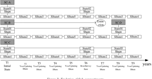
4.4 Evolution of Sub-compartment Objects
Fig-ure 7 shows sub-compartments evolved over time accord-ing to the forest resource spatiotemporal data model based on sequence states.
SC-A, SC-B and SC-C was three adjoining sub-compartments which were all created at T1 Timing. In the following year updating, each new stand state (sstate) was ap-pended as a snapshot to the stand state sequences except T6 timing, at which year new states from a reset survey were appended to the state sequences.
SC-D was created at T8 timing in a forestland occu-pation event (Fig.8) which also leaded to the extinction of SC-B and state changing of SC-A.
5
Data Storage, Data Query, and Data
Display
In this section, data storage structures, data query, and data display are discussed with an example of forest resource spatiotemporal database based on the forest resource spatiotemporal model designed in Section 4.
The experimental area was set in the town of Tai-huyuan in Linan County, Zhejiang Province, China. Class II survey data in 2005 and forest resources dynamic moni-toring data from 2008 to 2012 were used. The spatio tem-poral database is built based on arcsde10+ sqlserver2010, and the client program is developed using Visual Studio 2010 and ArcEngine 10.
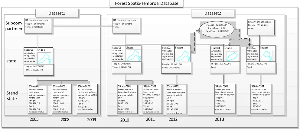
5.1 Geo-Entity Evolution The paper shows the
evo-lution of sub-compartment 018508002-001094 which has experienced an event and involves the following changes: (1) in 2005, the forest resource database was created based on a forest resource survey. (2) From 2008 to 2012, the forest stand factors were investigated each year. (3) In 2010, another forest resource survey was conducted. All information on all sub-compartments was investigated again. (Actually, the interval between two class II surveys in Zhejiang is 10 years, so another class II survey data set is lacking. This is a simulated data set to intensify the effect. The shape is from previous dataset with a few adjustments. ) (4) In 2013, the sub-compartment 018508002-001094 was divided into two parts, one part remained non-forest and another was afforested (became a new sub-compartment 018508002-001701).
5.2 Data Storage Figure 9 shows a forest resource
years
T1 Initial
State
T6
ResetSurvey State
T3
YearUpdating SState
T4
YearUpdating SState
T7
YearUpdating SState
Extin-ction
State01
SState1 Shape
T5
YearUpdating SState
T8
YearUpdating SState
T9
YearUpdating SState
SC-C
SState2 SState3 SState4 SState5
State02
SState1 Shape
SState2 SState3 SState4
T2 YearUpdating
SState
State01
SState1 Shape SC-B
SState2 SState3 SState4 SState5
State02
SState1 Shape
SState2 State01
SState1 Shape SC-A
SState2 SState3 SState4 SState5
State02
SState1 Shape
SState2 SState3 SState4
State01
SState1 Shape SC-D
SState2
State03 Shape
Figure 7: Evolution of Sub-compartments.
Before event
After event
A state2
B
state2 state3A state1D
Figure 8: Event of forestland occupation.
deleted from the picture. We have observed the following conditions: (1) in 2005, the database was created and all the sub-compartments were placed in storage. (2) Every year since 2008, a stand state table was added to record the forest stand state to represent the gradual change of the stand factors. (3) In 2010, Table State2010 was added after the forest resource survey to represent the gradual change of the shape and other attributes of the sub-compartment. The sub-compartment 018508002-001094 obtained a new state (Stat = 2). (4) In 2013, the sub-compartment 018508002-001094 was transferred to a new state (SID = 3) and a new sub-compartment 018508002-001701 was created for afforestation. The event information was recorded in the event table, and the event ID was recorded in the new state.
6
Data Display and Retrieval
Figure 10 presents an example of a client window. The control on the right side is named space-time cube. The space-time cube put forward by H¨agerstraand (1970) is the most famous method in 3D spatio-temporal data visualization and it is used to express the evolution of
forestlands in this study. The space-time cube has been delineated clearly and simply in many studies. Two of the cube axes represent space, and the third axis represents time, so the objects in the space-time cube have either a position coordinate or a time coordinate. In this study, the data in the database was all exported into the cube so that all the snapshots of the states and stand states could be observed as well as the events from the view. The stand state is represented by the tree symbols whose shapes and heights correspond to the species Composition and tree heights that are recorded in the stand state objects.
The state change of sub-compartment 018508002-001094 could be observed clearly in the space-time cube. The polygons in green was the shapes of three states of 018508002-001094 (there was no trees in the shapes of 018508002-001094 because the sub-compartment was a non-forest land), the shapes in blue is the new sub-compartments 001701 cut from 018508002-001094 for afforestation.
Dataset1
Forest Spatio-Temproal Database
Subcom-partment
state
Stand state
ID:0 18 5 09 0 0 90 0 19 0 4 Tbe g in˖20 0 5/1 0/1 7 Te nd˖20 09 /1 2/31
state01
Attributes: site g ra des, veg e tation community
SState0101
Attribute s: tree type, sta nd volume , a ve rag e heig ht, DBH T be g in˖
2 00 5/10 /1 7 T end˖
2 00 8/10 /3 1 me a sured value
2005 2008 2009 2010 2011
shape state01Attribute s:
site g rade s, ve g e ta tion community
shape
SState0102
Attribute s: tree type, sta nd volume , a ve rag e heig ht, DBH T be g in˖
2 00 8/1 1/0 1 T end˖
2 00 9/1 0/3 1 ca lculated value
SState0103
Attribute s: tree type , sta nd volume , a verag e he ig ht, DBH T be g in˖
2 00 9/1 1/0 1 T end˖
2 010 /1 0/3 1 ca lculated value
SState0101
Attribute s: tre e type, sta nd volume, a ve ra g e he ig ht, DBH T beg in˖
2 0 10/1 1/1 T e nd˖
2 0 11/1 0/3 1 me a sured va lue
SState0102
Attribute s: tre e type, stand volume , a ve ra g e he ig ht, DBH Tbe g in˖
20 1 1/1 1/0 1 Te nd˖
20 12 /1 0/3 1 ca lculate d va lue
Dataset2 ID:01 8 50 8 00 2 00 1 90 4
T be g in˖2 0 10/11/1 T end˖
ID:0 1 85 0 80 0 20 0 17 0 1 Tbe g in˖2 01 3/0 3/0 1 Te nd˖
state01
Attributes: site g ra des, veg e ta tion community
shape
SState0101
Attribute s: tre e type, sta nd volume, a ve rag e he ig ht, DBH T beg in˖
2 0 13/0 3/0 1 T e nd˖
2 0 13/1 2/3 1 me a sured value E ve ntID˖20 13 2 20 1 3
Eve ntT ype˖䙐᷇
E ve ntT ime˖2 0 1 3/0 3 /01
SState0301
Attributes: tree type , sta nd volume , ave ra g e he ig ht, DBH Tbe g in˖
20 1 3/03/07 Te nd˖
20 1 3/12/31 mea sure d va lue
state03
Attributes: site g ra des, veg e tation community
shape
2012
T beg in˖20 0 5/1 0/1 7 T e nd˖2 0 09 /12 /3 1
T be g in˖2 0 10/1 1/ 1 T end˖2 01 2/1 2 /31
T be g in˖2 0 13/0 3/0 1 T end˖
T be g in˖2 0 13/0 3 /0 1 T end˖
2013 state02
Attribute s: site g ra de s, ve g e ta tion community
shape
T be g in˖2 0 12/1 1/0 1 T end˖2 013 /0 3/0 1
SState0201
Attribute s: tre e type, sta nd volume, a ve rag e he ig ht, DBH T beg in˖
2 0 12/1 1/0 1 T e nd˖
2 0 13/0 3/0 1 me a sured value
Figure 9: The storage of Sub-compartment Spatiotemporal data.
Figure 10: Information on a sub-compartment.
cube. In Figure 7, the stand state layer is added with 3D tree symbols to represent stand information.
Table 2 shows the tree types and 3D symbols. Each tree type has a corresponding 3D symbol. The heights of the symbols are determined by Formula (2). Information
Table 2: Tree species and their 3D symbols
Species Symbol Species Symbol Species Symbol
Bamboo Fir Pine Massoniana
A tree control on the left side is used to display the classified and time information of spatiotemporal objects, e.g., the information on the sub-compartments (018508002-001701) is found in the control. The infor-mation is searched from different tables. The component of ArcEngine used to search is query filter, in which the search criteria is defined by the ‘where’ clause similar to the ‘where’ clause of the SQL sentence. The sub-compartment is to be searched first, where the ‘where’ clause is “SCID = ‘001701’ and vid = ‘018508002”’. The ‘Tbegin’ attribute in the searched row can be used to judge that State2010 is the table that includes the ini-tial state of the sub-compartment. We can also search State2010 with the condition “vid = ‘01851005’ and scid = ‘001701’ and state = ‘01”’. The stand state is searched from the table StandState2010 with the following con-dition: “vid = ‘01851005’ and SCID = ‘001701’ and State = ‘01’ and standstate = ’*2005”’. Every states and stand states that belongs to a sub-compartment can be searched in the same manner.
Historical retrospect and representing a particular his-torical moment are the proper and necessary functions of the temporal geographic information system. Histor-ical retrospect refers to the search for the ancestors of an entity assigned by the user. Representing a particu-lar historical moment refers to restoring the state to a particular historical moment(Teng, Liu, & Liu 2005).
Historical retrospect depends on the event informa-tion, which is described using the sub-compartment 018508002-001701 as an example. As shown in Fig-ure 8, the event information can be retrieved by the ID (201323001) recorded in the state 01, which is the current state of the sub-compartment 018510026-001701. According to the event list, the ID of the father sub-compartment (018508002-001904) and its state can be found and expanded.
7
Conclusions
The paper proposed an object-oriented forest spa-tiotemporal data model based on sequence states method
to express the sub-compartment evolution process. An ex-ample showed that all data can be stored and related well in the database constructed based on the data model. In the client window, not only the history of a sub-compartment but also its ancestor sub-sub-compartment can be retrieved and displayed. Using space time cube and history tree to visualize the evolution of forest land is a feature of this study.
Acknowledgements
This research was supported by Zhejiang Provincial Natural Science Foundation of China (Y5110145), Zhe-jiang Agriculture & Forestry University Research Devel-opment Foundation (2014FR086), and Research Centre for Smart Agriculture and Forestry (2013ZHNL01).
References
Claramunt, C., Parent, C., & Th´eriault, M. 1997. Design patterns for spatio-temporal processes. In Searching for Semantics :Data Mining, Reverse Engineering , S. Spaccapieta and F. Marganski (Eds), 415–428. DOI: 10.1007/978-0-387-35300-5 19.
Gao, J. P. 2007. Study on Updating and Managing Meth-ods of Basic Data of Forest Resource Basing on Tem-poral GIS (Doctoral dissertation: Beijing Forestry University).
Gao, J. P., & Lu, S. Y. 2008. Unified Spatio-temporial Data Model of Dynamic Updating and Management for Forest Resources Data. Journal of Northwest Forestry University, 23(5): 188–192.
Gebbert, S., & Pebesma, E. 2014. A temporal GIS for field based environmental modelling. Environ-mental Modelling & Software, 53(3), 1–12. DOI: 10.1016/j.envsoft.2013.11.001.
Langran, G., & Chrisman, N. R. 1988. A framework for temporal geographic information. Cartographica: The International Journal for Geographic Information and Geovisualization, 25(3), 1–14. DOI: 10.3138/ K877-7273-2238-5Q6V.
Liu, Q. L., Deng, M., Wang, J. Q., Peng, S., Mei, X. M., & Zhao, L. 2011. Spatio-temporal outliers detection within the space-time framework. Journal of Remote Sensing, 15(3), 457–464.
Liu, X. Y. 2004, Survey on the Rational Division of Small Classes of Forest Resources. Forest Investigation Design, 39(3):9–10.
Mari, J. F., & Benoˆıt, M. 2013. Time space stochastic modelling of agricultural landscapes for environmental issues. Environmental modelling & software, 46(8), 219–227. DOI:10.1016/j.envsoft.2013.03.014
Monitoring Center for Forest Resources in Zhejiang Province. 2004. Detailed technology rules and regu-lations of planning, designing and survey for forest resource of Zhejiang province. Hangzhou: Zhejiang Forestry Department.
Monitoring Center for Forest Resources in Zhejiang Province. 2008. Measures of Archives Management for forest resource in ZheJiang Province. Hangzhou: Zhejiang Forestry Department,.
National Administration of Surveying, Mapping and Geoinformation. 2012. Platform for geo-information common services Data specification for entity, geo-graphic name and address (Ch/z 9010–2011), Beijing: surveying and mapping press.
Peuquet, D., & Wentz, E. 1994. An approach for time-based analysis of spatiotemporal data. In T. C. Waugh, & R. G. Healey (Eds.), Advances in GIS research. Proc.
6th symposium, Edinburgh, 1994. Vol. 1. (pp. 489–504). Taylor & Francis, London.
Pinet, F. 2012. Entity-relationship and object-oriented formalisms for modeling spatial environmental data. Environmental Modelling & Software, 33, 80-91. DOI:10.1016/j.envsoft.2012.01.008
Rasinm¨aki, J. 2003. Modelling spatio-temporal environ-mental data. Environenviron-mental Modelling & Software, 18(10), 877–886. DOI: 10.1016/S1364-8152(03)00106-3.
Rasinm¨aki, J. 2007. Management of multi-scale forest resource data over time. Dis-sertationes Forestales, Available online at: http://www.metla.fi/dissertationes/df49.htm. Last accessed Oct. 08, 2016.
Tang J. K.,Tang D. S., HU J. 2008. Study on the Appli-cation of Temporal GIS and Version Management in the Updating of Forest Resources Data, Central South Forest Inventory and Planning. 27(1): 46–49.
Teng, L. M., Liu, R. Y., & Liu, N. 2005. A study on spatio-temporal data model based on feature and event. Journal of Remote Sensing, 9(6):634–639.
Xia, K., Liu, R.Y., Liu, N., Xie, J. & Zhang, F. 2013. Research of Forestry Spatio-temporal Data Model in Sequence States. Acta Geodaetica et Cartographica Sinica, 42(3):433–439.
Xia, K., Liu, R. Y., Liu, N., Zhang G. J. 2014. Updat-ing Framework for Multi-Sources of Sub-compartment Spatio- Temporal Data. Scientia Silvae Sinicae, 50(8):15–21.